The obvious visual evidence for assuming Mars once had catastrophic floods

The obvious visual evidence of past catastropic floods on Mars
Click for original image.

Since the first comprehensive orbital data of Mars was sent back in the early 1970s by Mariner 9, scientists have generally concluded that many of the features seen at the eastern end of the giant Valles Marineris canyon were caused by one or several catastrophic floods.

The picture to the right, rotated, cropped, and reduced to post here and taken on July 26, 2024 by the high resolution camera on Mars Reconnaissance Orbiter (MRO), provides a good example of why the scientists have come to that conclusion. It shows what the camera team labels a “streamline feature surrounding crater.” I have added the arrows to indicate the presumed direction of flow. The flow went around this 2.5-mile-wide unnamed crater because the impact had compacted it, making it resistent to erosion. The flow however was strong and large enough to wash away the plateau on which the crater sits, as well as cutting into the crater’s southwest rim. In addition, the rim on the southeast was also cut through at some point, this time from what might have been flow eddies as the flood pushed past.

Hence, the theory of catastrophic floods.

» Read more

1 comment

A galaxy squashed as it plows its way through the intergalactic medium

A galaxy squashed by a vacuum
Click for original image.

Time for another cool image on this relatively slow day in the space news business. The picture to the right, cropped, reduced, and sharpened to post here, was taken by the Hubble Space Telescope and released today by the European Space Agency’s press department. From the caption:

Appearances can be deceiving with objects so far from Earth — IC 3225 itself [the galaxy to the right] is about 100 million light-years away — but the galaxy’s location suggests some causes for this active scene, because IC 3225 is one of over 1300 members of the Virgo galaxy cluster. The density of galaxies in the Virgo cluster creates a rich field of hot gas between them, the so-called ‘intracluster medium’, while the cluster’s extreme mass has its galaxies careening around its centre in some very fast orbits. Ramming through the thick intracluster medium, especially close to the cluster’s centre, places an enormous ‘ram pressure’ on the moving galaxies that strips gas out of them as they go.

IC 3225 is not so close to the cluster core right now, but astronomers have deduced that it has undergone this ram pressure stripping in the past. The galaxy looks as though it’s been impacted by this: it is compressed on one side and there has been noticeably more star formation on this leading edge, while the opposite end is stretched out of shape. Being in such a crowded field, a close call with another galaxy could also have tugged on IC 3225 and created this shape. The sight of this distorted galaxy is a reminder of the incredible forces at work on astronomical scales, which can move and reshape even entire galaxies!

What makes the impact on this galaxy of that intercluster medium so astonishing is that medium is so relatively empty of material. The space between galaxies in the Virgo cluster is in all intents and purposes a vacuum far more empty than any that we can create in a chamber on Earth. And yet it was enough to distort this galaxy and cause star formation on the galaxy’s leading edge.

5 comments

Young lava on the Moon?

Young lava on the Moon?
Click for original image.

Cool image time! The photo to the right, cropped and reduced to post here, was taken on November 27, 2023 by Lunar Reconnaissance Orbiter (LRO) and was today featured by the science team. From their caption:

One of the early findings from the LRO mission was the discovery of volcanic features known as Irregular Mare Patches (IMPs) scattered across the nearside. These landforms are generally considered volcanic. However, their ages are hotly debated. They may be as young as 50 million years or as old as 3.5 billion years. The Aristarchus IMP (25.045°N, 313.233°E) is one of the smallest and most enigmatic IMP. The fact that this IMP is found within the Aristarchus crater ejecta suggests it formed after the crater, which is dated at 200 million years.

Alternatively, this IMP may have formed as part of ejecta emplacement from the Aristarchus crater forming impact. However, no other crater ejecta on the Moon exhibits a similar landform.

Astronomers for decades before and since Sputnick have reported what appears to be some activity in the Aristachus region, though none of those reports have ever been confirmed. In LRO’s long mission orbiting the Moon it has not yet detected any obvious changes there, suggesting that there is little or no present activity. These patches however appear to indicate activity in the relatively recent past.

The patches however also indicate activity that seems alien. Why would the lava form in this manner, as rough patch of knobs, sometimes aligned, sometimes not?

0 comments

A different kind of chaos on Mars

A different kind of chaos on Mars
Click for original image.

Cool image time! The picture to the right, rotated, cropped, reduced, and sharpened to post here, was taken on June 23, 2024 by the high resolution camera on Mars Reconnaissance Orbiter (MRO). I had originally chosen to feature a different picture of this spot, taken on August 1, 2024 in order to create a stereo pair, but this week the camera team featured this first photo, providing a caption.

This disrupted surface is characterized by a collection of rounded to flat-topped mounds of various sizes connected by narrow flat floors, typical of the aptly named “chaotic terrain” on Mars.

What could have caused this flat surface to break into pieces? You might imagine that a flat surface could be broken up if it was inflated or collapsed. One hypothesis is that large amounts of water were released from deep below the ground to cause the surface break up.

Normally on Mars, especially in the mid-latitudes, chaotic terrain is associated with glacial activity, suggesting that glaciers over time erode valleys along random criss-crossing fault lines to create the mesas and canyons. This patch of chaotic terrain however suggests a different formation process.
» Read more

2 comments

A water sprinkler in space

A sprinkler in space

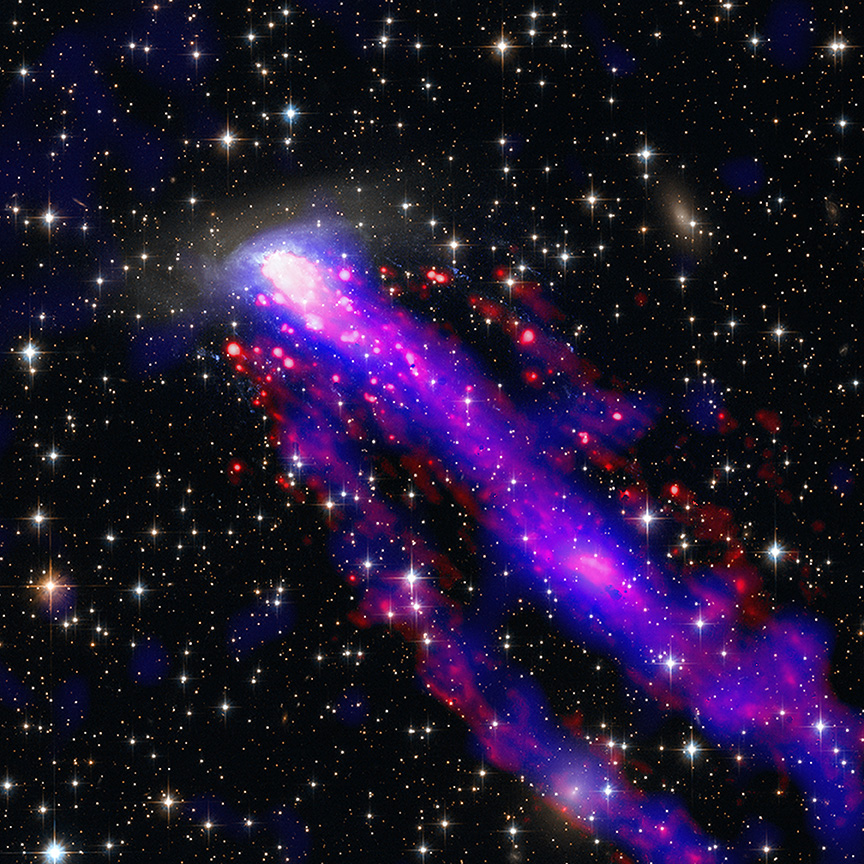
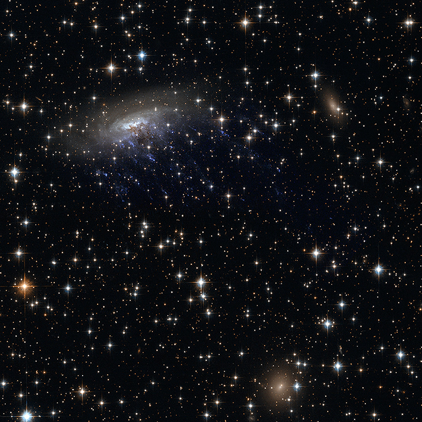
Cool image time! The picture to the right, cropped, reduced, and sharpened to post here, was taken by the Hubble Space Telescope as part of a long term program to monitor changes in the R Aquarii binary star system, located about 700 light years away.

R Aquarii belongs to a class of double stars called symbiotic stars. The primary star is an aging red giant and its companion is a compact burned-out star known as a white dwarf. The red giant primary star is classified as a Mira variable that is over 400 times larger than our Sun. The bloated monster star pulsates, changes temperature, and varies in brightness by a factor of 750 times over a roughly 390-day period. At its peak the star is blinding at nearly 5,000 times our Sun’s brightness.

When the white dwarf star swings closest to the red giant along its 44-year orbital period, it gravitationally siphons off hydrogen gas. This material accumulates on the dwarf star’s surface until it undergoes spontaneous nuclear fusion, making that surface explode like a gigantic hydrogen bomb. After the outburst, the fueling cycle begins again.

This outburst ejects geyser-like filaments shooting out from the core, forming weird loops and trails as the plasma emerges in streamers. The plasma is twisted by the force of the explosion and channeled upwards and outwards by strong magnetic fields. The outflow appears to bend back on itself into a spiral pattern. The plasma is shooting into space over 1 million miles per hour – fast enough to travel from Earth to the Moon in 15 minutes! The filaments are glowing in visible light because they are energized by blistering radiation from the stellar duo.

The press release likens these filaments to the spray thrown out by a water sprinkler, and I must say that’s an apt description.

Since 2014 scientists have taken regular pictures of R Aquarii, and found that the central structures have been changing in a perceptible manner, despite their gigantic size. Below is a movie created from five photos taken from 2014 to 2023.
» Read more

0 comments

Spring etch-a-sketch near the Martian south pole

Spring etch-a-sketch near the Martian south pole
Click for original image.

Cool image time! The picture to the right, cropped, reduced, and sharpened to post here, was taken on May 28, 2024 by the high resolution camera on Mars Reconnaissance Orbiter (MRO). Labeled merely as a “terrain sample,” it was likely snapped not as part of any specific research project but to fill a gap in the camera’s schedule so as to maintain its proper temperature.

The camera team tries to find interesting geology when they do this, and are frequently successful. In this case the image shows some truly alien Martian terrain at 77 degrees south latitude, about 475 miles from the south pole.

What are we looking at? I promise you it isn’t the iron filings found inside an Etch-A-Sketch drawing toy. My guess is that the base layer is the light areas, a mixture of ice and debris impregnated with dust and eroded into the unique Martian geological feature dubbed brain terrain. As for the dark lines and splotches, their explanation might lie in the time of year, the spring.
» Read more

1 comment

The pimpled floor of Isidis Basin on Mars

The pimpled floor of Isidis Basin on Mars
Click for original image.

Cool image time! The picture to the right, cropped, reduced, and sharpened to post here, was taken on May 21, 2024 by the high resolution camera on Mars Reconnaissance Orbiter (MRO). Labeled merely as a “terrain sample,” it was likely taken not as part of any specific research project but chosen by the camera team to fill a gap in the camera’s schedule in order to maintain its proper temperature.

When they do this they try to pick a target that is somewhat interesting, though it is not always possible. In this case it appears they succeeded in capturing a location filled with lots of puzzling stuff, including low 60-to-80-foot-high mesas with either flat- or hollow-tops, shallow craters that appear almost buried, and other craters that appear so deep and shadowed that it is even possible these are skylights into underground caves.

In between these features the flat landscape has a scattering of ripple dunes, all oriented in the same direction and thus implying that the prevailing winds are or were blowing from the northeast to the southwest.
» Read more

0 comments

Monitoring a changing spot on Mars

Monitoring a changing landscape on Mars
Click for original image.

Cool image time! The picture to the right, cropped, reduced, and sharpened to post here, was taken on July 18, 2024 by the high resolution camera on Mars Reconnaissance Orbiter (MRO). Based on its label, “Dark Filamentary Streak Year-Round Monitor Site in Promethei Terra,” it was apparently taken as part of a long-term project to monitor the changes that occur at this particular spot on Mars.

This monitoring began in 2008, not long after MRO began science operations. In that first image, taken in the Martian autumn, almost the entire terrain was covered with dust devil tracks, all running more-or-less parallel to each other in a northwest-to-southeast direction.

That unusual tiger-striped landscape prompted later monitoring. However, a follow-up photo in 2010, also in autumn, showed practically no dust tracks here at all. Another image, taken in 2011 during the Martian summer, showed new dust devil tracks, but instead of being aligned as in 2008, the tracks went in all directions, with only a hint of alignment to the southeast.
» Read more

1 comment

Curiosity’s upcoming travel route

Curiosity's upcoming route
Click for original image.

Overview map
Click for interactive map.

Cool image time! The panorama above, cropped and annotated to post here, was taken on October 6, 2024 by the right navigation camera on the Mars rover Curiosity. It looks south, down the slopes of Mount Sharp and across Gale Crater, the distant crater rim barely visible through the dusty air twenty to thirty miles away.

The overview map to the right provide the context. The blue dot marks Curiosity’s present position. The yellow lines the approximate area covered by the panorama. The red dotted line indicates the rover’s planned route, with the white dotted line the path it has recently traveled.

As you can see, the rover has moved up onto a higher terrace surrounding the Texoli butte, and will now travel downhill a bit to skirt around its northern nose. From there, the science team plans to send the rover westward, traversing along the contour lines on the side of Mount Sharp. Along the way it will lose more elevation, but eventually, after passing several parallel north-south trending canyons, it will finally turn south into one canyon to resume its climb up the mountain.

To review the rover’s journey, Curiosity during its dozen years on Mars has traveled just over 20 miles and climbed about 2,500 feet. The peak of Mount Sharp however is still about 26 miles away and about 16,000 feet higher. Getting there will probably take at least three more decades, which is possible since the rover uses a nuclear power source similar to that used by the two Voyager interplanetary probes, now functioning in space for almost a half century.

In fact, it would not surprise me if the first human Mars colonies are established while Curiosity is still working, and that in its later years it sends its data to that colony directly (via an orbiting relay satellite), rather than beaming it back to Earth.

3 comments

Frozen Martian eddies at the confluence of two glacier rivers

Frozen eddies at the confluence of two glacial rivers
Click for original image.

Cool image time! The picture to the right, rotated, cropped, reduced, and sharpened to post here, was taken on July 3, 2024 by the high resolution camera on Mars Reconnaissance Orbiter (MRO).

The science team labels the photo as capturing a “contact near Reull Vallis,” a 1,000-mile-long Martian canyon that flows down the eastern slopes of Hellas Basin, the death valley of Mars.

What I see isn’t a geological contact but a complex jumble of odd-shaped depressions and mesas, surrounded by an eroded surface that seems squashed and deformed by some process. If this is all we had to go on, I would simply label this as another “What the heck?” image on Mars and move on. However, the larger context of the overview map helps explain it all, at least as best as we can explain using orbital data.
» Read more

0 comments

The strange terrain of the Martian southern ice cap

The strange terrain of Mars' south pole
Click for original image.

Cool image time! The picture to the right, rotated, cropped, and sharpened to post here, was taken on July 29, 2024 by the high resolution camera on Mars Reconnaissance Orbiter (MRO). It shows a section at the Martian south pole at the very high latitude of 87 degrees south, only about 100 miles from the pole itself.

The label for this picture is “possible water ice and mesas,” suggesting we are looking at an ice cap of water that is partly sublimated away.

In truth, things are much more complicated. It was summer when this photo was taken. Note the drainage in the lower right and the dark spidery lines there. In the winter on Mars atmospheric carbon dioxide falls as snow and coats the poles to about 60 degrees latitude with a thin mantle of dry ice. In the spring this mantle sublimates away, but does so in an counter-intuitive manner. The sublimation first occurs at the mantle’s base, and the trapped gas flows up until it finds a weak spot in the mantle and cracks through, spewing out and deposting dark splotches of dust.

At the south pole this upward flow always follows the same paths, producing the dark spidery patterns we see here. In the case of the drainage in the lower right, this is a drainage of gas eastward until it pops out at the slope, causing that depression to become darkly stained.

This is only part of the story of this complex geology, however.
» Read more

0 comments

Perseverance looks uphill

Perseverance looks uphill
Click for full resolution. The original images can be found here and here.

Cool image time! The panorama above was created by me from two pictures taken today by the left navigation camera on the Mars rover Perseverance (found here and here). The haziness in the air is the left over from a local dust storm in Jezero Crater during the past month.

On the overview map below, the blue dot marks Perseverance’s present position, with the red dotted line indicating the approximate planned route of the rover uphill. The yellow lines are my guess as to the area covered by the panorama above. That guess could be wrong, as not all the features in the picture match the overview map. The view could be much closer, with the hill and ridgeline nothing more than the small outcrops close to the rover.

Nonetheless, these navigation pictures show us the kind of terrain the rover will be climbing as it works its way up the rim of Jezero Crater. The ground is relative smooth, though steep. My guess is that this is about a 25% grade, which on Earth would be a problem but on Mars it is a grade that NASA’s other rover, Curiosity, has routinely traversed. Perseverance has not yet traveled this kind of steepness, but there is no reason to expect it to have any difficulties doing so.

Overview map
Click for interactive map.

1 comment
1 36 37 38 39 40 89