China releases images of Tianwen-1 on way to Mars

Tianwen-1 on its way to Mars

China has released several images taken of its Tianwen-1 orbiter/lander/rover by a camera ejected by the spacecraft on its way to Mars.

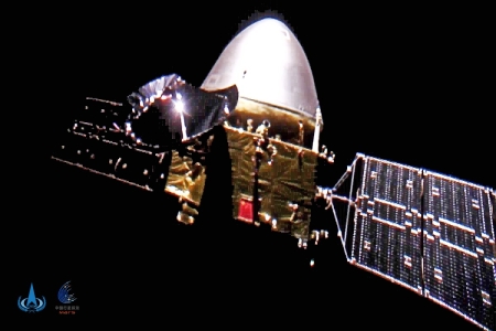
The images released by the China National Space Administration on Oct. 1 show the Tianwen 1 spacecraft traveling through the blackness of space. Tianwen deployed a small camera to take the self-portrait as it tumbled away from the mothership.

Two wide-angle lenses on the deployable camera were programmed to one image every second. The images were transmitted back to Tianwen via a wireless radio link, then downlinked back to ground teams in China.

In the images, Tianwen 1’s solar array wings and dish-shaped high-gain communications antenna are prominently visible. The white section of the spacecraft is the mission’s entry module and heat shield, which contains a Chinese rover designed to land on Mars and explore the surface.

The spacecraft is about halfway to Mars, and will arrive in Mars orbit in February. It will then spend several months surveying its candidate landing sites, of which there appear to be two, before releasing the lander/rover to the surface.

5 comments

Cliffs of Martian ice

southern hemisphere Martian ice scarp
Click for full image.

Today’s cool image to the right, cropped to post here, shows an ice scarp located in the high southern latitudes south of Hellas Basin. It was taken on August 15, 2020 by the high resolution camera on Mars Reconnaissance Orbiter (MRO), and was released today as a captioned image. From the caption:

Scientists have come to realize that, just below the surface, about one third of Mars is covered in ice. We study this ice to learn about Mars’ ancient climate and astronauts’ future water supplies.

Sometimes we see the buried ice because cliffs form like the one in this image. On the brownish, dusty cliff wall, the faint light-blue-colored ice shows through. [emphasis mine]

This ice scarp is one of about two dozen [pdf] that have so far been found within the latitude bands of approximately 45 to 65 degrees latitude in both the north and south hemispheres. The data so far obtained suggests that the scarp exists because of a pure water ice layer just below the surface. Over time this pole-facing cliff retreats away from the pole towards the equator, leaving behind it an extended pit. In the cliff wall scientists think they have detected evidence of that water ice layer.

Blue in MRO hi-res images can indicate both water as well as very rough surfaces. While much of the blue here could be ether, the blocky cracks suggest it is ice. As explained by Colin Dundas of the U.S. Geological Survey’s Astrogeology Science Center in Arizona and lead author of the pdf above,

The crack patterns are likely thermal contraction cracks, which form in shallowly buried ice due to seasonal temperature changes causing it to expand and contract. When that repeats over many years it creates regular patterns of cracks that organize themselves into polygons.

The overview image below gives the location of all known such scarps, as of March of 2020, taken from the pdf paper that I linked to above.
» Read more

0 comments

Criss-crossing Martian ridges hit by new impacts

Criss-crossing Martian ridges hit by new impacts
Click for full image.

The image to the right, cropped to post here, is a captioned photo from the high resolution camera on Mars Reconnaissance orbiter and released today. From the caption:

The black spots [recent impacts] form because the craters exposed cleaner materials in the subsurface beneath the bright, dusty surface.

Our image is also interesting because the surface has a criss-cross pattern formed by wind activity. Bright ripples that are oriented from the upper right to the lower left are perpendicular to the wind flow. In contrast, outcrops that have been eroded by the wind are oriented perpendicular to the ripples to produce the criss-cross pattern we now observe.

The overview map below might also help explain this criss-cross pattern.
» Read more

4 comments

A donut on the Moon

A donut crater on the Moon
Click for full image.

In this case the donut is a crater dubbed Bell E Crater, with a second concentric rim in its interior. The photo to the right, reduced to post here, was taken by Lunar Reconnaissance Orbiter (LRO) as part of its high resolution survey of the entire Moon. As noted at the first link:

Craters not only vary in shape but also in complexity. There are simple craters and complex craters with ring structures and mountains at the center. Somewhere in between is Bell E, a small crater located within the larger Bell crater. These donut-shaped formations are commonly known as concentric craters. Many questions remain on the origin of donut craters. While there have been several ideas about their origin, including double impacts, the currently favored hypotheses involve volcanic processes and compositional variations.

The article outlines four hypotheses for explaining this crater’s formation, a perfectly aligned double impact, ripples at impact into thick warm lava, layers of different densities, and later volcanic activity. None do a good job of explaining all of the concentric craters found on the Moon, and thus suggest that these craters might have formed from some combination of more than one theory.

0 comments

On the rim of Mars’ Grand Canyon

The rim of Valles Marineris
Click for full image.

Cool image time! Mars has many grand geological features that will surely attract tourists in the far future, when the planet has been successfully colonized and humans live there with the same ease that we today live in what was the New World wilderness several hundred years ago.

Of those features, none probably compare with Valles Marineris, the largest known canyon in the solar system. When compared to it, the Grand Canyon — at about a mile deep, about ten miles wide, and about 280 miles long — is a mere pothole, hardly noticeable. Valles Marineris averages a depth of five miles, a width of 370 miles, and a length of 1,900 miles. You could fit many Grand Canyons within it.

The photo to the right, cropped to post here, was taken on July 13, 2020 by the high resolution camera on Mars Reconnaissance Orbiter (MRO). It shows only a tiny section of this gigantic canyon’s rim. At this spot the depth from rim to floor is about 4.3 miles, or about 22,700 feet. In the image itself I estimate the cliff at the rim to be somewhere between 6,000 to 8,000 feet high, more than the depth of the entire Grand Canyon. And that’s only this top cliff.

The three overview maps below show the context of this location within Valles Marineris.
» Read more

3 comments

Big scallops in the Martian southern latitudes

Big scallops on Mars
Click for full image.

Cool image time! The photo to the right, rotated, cropped, and reduced to post here, shows an example of some large scalloped depressions in the high southern latitudes of Mars.

Taken by the high resolution camera on Mars Reconnaissance Orbiter (MRO) on June 27, 2020, these scallops resemble in many ways the ice scarps that scientists have previously found at this same latitude, both to the east and west of where these scallops are located. With those scarps, the data suggests that a very pure layer of ice is visible in the cliff face, and that over time the cliff retreats northward due to sublimation of that ice.

The scallops in the photo to the right suggest the same process, though the differences raise questions. As explained by Colin Dundas of the U.S. Geological Survey’s Astrogeology Science Center in Arizona,
» Read more

0 comments

New study confirms liquid water under Mars’ south pole

A new study has confirmed earlier work that suggested there were liquid lakes of water under the Martian south pole.

The data appears to indicate that the bodies are “hypersaline solutions” –a brine in which high concentrations of salt are dissolved in water – which is perhaps the reason they are able to stay liquid despite the very cold conditions of Mars’s south pole.

The fact that there is a whole set of lakes suggests that they have probably formed relatively easily, and that versions of them may therefore have been present throughout the history of the planet. [emphasis mine]

There is one problem with hypothesis indicated by the highlighted words. Mars’ rotational tilt (its obliquity) shifts significantly, from 0 to 60 degrees. Right now it is tilted about 25 degrees, similar to Earth. The south pole as we see it today will have been very different at different obliquities, which means there is no way to assume these posited underground lakes would have been there.

1 comment

Martian channels formed by water? by ice? by lava?

Meandering channels on Mars
Click for full image.

Many of the pictures from Mars show meandering channels, all of which suggest an erosion process related to some form of flow. For most of the last half century, since the first images of these channels were beamed back by Mariner 9 in 1972, scientists had believed that liquid water must have caused them. The accumulating recent photos from Mars now tentatively suggest that these channels might have instead been caused by glacial processes, creeping frozen water instead of liquid.

The image to the right, rotated, cropped, and reduced to post here, was taken on July 17, 2020 by the high resolution camera on Mars Reconnaissance Orbiter. The channels suggest some form of flow going downhill to the northwest, but was it caused by water or ice? There is no obvious visual evidence of glaciers in this image, nor is there any such evidence that I can spot in any of the nearby high resolution images of this same region, despite the fact that at 35 degrees north latitude it is in the mid-latitude band where scientists have identified many glacial features.

The region itself is called Mareotis Fossae, an area of southwest-to-northeast trending parallel fissures and ridges, as shown in the two overview maps below.
» Read more

1 comment

An ice-covered mountain on Mars?

Ice-covered mountain on Mars?
Click for full image.

Grinnell Crater in Glacier National Park in 2017

Today’s cool image, taken on July 1, 2020 by the high resolution camera on Mars Reconnaissance Orbiter, is of a mound-like mountain on Mars that to all intents and purposes appears covered by glacial ice, some eroded, some not.

The image to the right, rotated, cropped, and reduced to post here, shows this mound. Both the flow coming down from the mountain top down the north slope as well as the flow in the north that appears to begin in a small crater suggest glacial features.

Even more convincing are what appear to be patches of glacial ice on the southern slopes, resembling the kind of glacial patches you see everywhere in Glacial National Park. The second photo to the right, taken by me on our visit to Glacier National Park in 2017, shows similar patches hugging the mountainside at Grinnell Glacier.

This Martian mountain is located in the southern hemisphere inside Hellas Basin on its eastern interior rim. (See the overview map below, with the location of this photo the small white box south of Harmakhis Valles.) Thus, you would expect the north-facing slope to get more sunlight (and more heat) than the south-facing slopes. Yet, from this image there appears to be greater erosion on the south-facing slopes. A puzzle indeed.
» Read more

5 comments

OSIRIS-REx team confirms date for sample grab from Bennu

Nightingale landing site on Bennu
Click for full image.

The OSIRIS-REx science team has confirmed October 20, 2020 as the date the spacecraft will attempt a sample grab from the asteroid Bennu.

OSIRIS-REx is charged with collecting at least 2 oz. (60 grams) of Bennu’s rocky material to deliver back to Earth – the largest sample return from space since the Apollo program – and the mission developed two methods to verify that this sample collection occurred. On Oct. 22, OSIRIS-REx’s SamCam camera will capture images of the TAGSAM head to see whether it contains Bennu’s surface material. The spacecraft will also perform a spin maneuver on Oct. 24 to determine the mass of collected material. If these measures show successful collection, the decision will be made to place the sample in the Sample Return Capsule (SRC) for return to Earth. If sufficient sample has not been collected from [the primary landing site] Nightingale, the spacecraft has onboard nitrogen charges for two more attempts. A TAG attempt at the back-up Osprey site would be made no earlier than January 2021.

The press release at the link provides a lot of technical and interesting details about the sample-grab-and-go attempt, expected to put the spacecraft in contact with the asteroid’s surface for no more than sixteen seconds.

The maneuver itself is quite risky, as the available smooth landing area, as shown in the image above, is only half the size the equipment was designed for, and surrounded by large boulders.

0 comments

Corroding glacier in crater rim gully?

Gully in crater rim
Click for full image.

Today’s cool image to the right, rotated and cropped to post here, shows a gully flowing down the north facing rim of a 30-mile-wide crater in the southern cratered highlands. It was taken on June 30, 2020 by the high resolution camera on Mars Reconnaissance Orbiter (MRO).

To my eye the corroded ridges and pits running down the western side of this gully look like a corroded ice, as if we are looking at a glacier that the light of the Sun, which in the southern hemisphere hits this north-facing slope more directly and for longer periods of time, is causing it to sublimate away with time.

The wider shot below shows the entire rim, flowing downhill from the south to the north.
» Read more

0 comments

A patch of chaos in the Martian cratered southern highlands

A patch of chaos in the southern cratered highlands of Mars
Click for full image.

Today’s cool image, rotated, cropped, and reduced to post here, takes us to the cratered southern highlands of Mars. Taken by the context wide angle camera on Mars Reconnaissance Orbiter, this image shows us a strange isolated patch of what appears to be chaos terrain, which on Mars generally means an area of random knobs and mesas cut by canyons and channels.

The large bulk of chaos terrain on Mars is found near or in the transition zone between the lowland northern plains and the southern cratered highlands, and is thought to have been created by slow erosion, possibly by glaciers. This erosion process is aided by the gradient downhill from those highlands to the lowlands.

This location however is in the middle of the cratered highlands, and shows no obvious slope in any direction. And though the location is in the mid-southern latitudes, there is no obvious evidence of glaciers among these knobs and mesas. Furthermore, the mesas are not all the same height. Instead, a large portion appear to have been shaved off, as if some giant came in with a putty knife and scrapped away at them.

This can be clearly seen by the close-up below, taken by MRO’s high resolution camera on July 16, 2002 of the area indicated by the white box, which for scale is about 2 1/4 miles square.
» Read more

3 comments
1 105 106 107 108 109 157