InSight has buried its Mole

The Mole buried

Using the scoop on InSight’s robot arm, engineers have now successfully filled the large hole that had formed around the spacecraft’s mole, the drill that has been trying but failing to dig down about fifteen feet so that a heat sensor could measure the internal temperature of Mars.

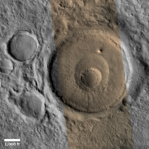
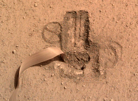
The image to the right shows the filled hole with the mole’s communications tether snaking away. Earlier this month they used InSight’s scoop to scrape surface material into the hole, as planned in June. According to the mole’s principle investigate, Tilman Spohn,

I had estimated that the first scrape of 12 centimetres swath length would raise the bottom of the pit but leave the Mole sticking out of the sand. By the way, this was the condition for some to agree to the quite controversial ‘scratch test’. As one can see in the image from Sol 600 shown below, that estimate was not quite right. The scraping was a complete success! The scrape was much more effective than expected and the sand filled the pit almost completely. The Mole is now covered, but there is only a thin layer of sand on the back cap.

Their next step will be to use the scoop to press down on the dirt of the filled hole, with the hope this added pressure will keep the dirt pressed against the mole as it hammers downward, thus holding it place with each downward stroke.

4 comments

Bright-tipped perplexing terrain on Mars

Perplexing terrain on Mars
Click for full image.

The photo to the right, rotated, cropped, and reduced to post here, was taken by the high resolution camera on Mars Reconnaissance Orbiter (MRO) on June 24, 2020, and shows a bit of inexplicable country in Arabia Terra, the widest and largest transition zone region on Mars between the northern lowland plains and southern cratered highlands.

The stuff visible in this image falls into what I call “What the heck?” geology. It is very clear we are looking at a collection of straight and curved ridges and mesas, all of which for some reason are bright at their tips and edges. Some of the curved ridges might be the rims of craters, but only some. Other ridge lines look more like leftovers following a strange erosion process. The problem is that to my uneducated eye I can find little rhyme or reason to these shapes. The mesas and canyon on the image’s right edge might be explained by the erosion processes that create chaos terrain on Mars, but that process does not do a good job of explaining anything else in the photo.

That this uncaptioned image is merely labeled “Arabia Terra” suggests that the scientists involved in getting this image were equally perplexed by it, and could not give it a better description.

The overview map below provides some location context, including how this geology relates to the landing site of Europe’s Rosalind Franklin rover, now scheduled for a 2022 launch.
» Read more

2 comments

The longest lava tube in the solar system?

A lava tube on Mars
Click for full image.

Before I delve into today’s cool image, I think it important to explain to my readers why I seem to post so many cool images from Mars. The simple explanation is that Mars right now is where almost all the cutting edge planetary research is taking place, and as a science journalist focused on space exploration I must go to that cutting edge. My dear readers know that I love variety (just consider the evening pauses on Behind the Black), but you can’t ignore the reporting of real discoveries simply to increase the diversity of one’s posts. This is too often what modern news outlets do, which is also why they often miss the real story.

Anyway, today’s cool image to the right, rotated, cropped, and reduced to post here, shows only a small section of what might be the longest lava tube in the entire solar system. Taken on May 5, 2020 by the high resolution camera on Mars Reconnaissance Orbiter (MRO), it shows a string of pits along a meandering depression coming down the northwest flank of the giant volcano Arsia Mons. The image was a follow-up to a July 2014 photo of the same location, and was taken to produce a stereo pair.

The feature strongly suggests a lava tube, with the pits being skylights into the meandering underground void. From top to bottom this section of the tube is a little over three miles long. Since there are lava tubes on Earth far longer, this one image hardly makes this the longest tube in the solar system.

The tube, however, extends off the image both at the bottom and at the top. Not many high resolution images have been taken in this area, so it is therefore hard to say how far the tube extends. Other nearby high resolution images in this area however have found similar lava tubes, which conceivably could be part of the same tube. The overview map below shows the relationship.
» Read more

3 comments

A collapsed Martian crater in a glacier?

Collapsed crater in glacier?
Click for full image.

Today’s cool image to the right, cropped and reduced to post here, is another example of evidence that the mid-latitudes of Mars are covered with glaciers and ice. The photo, taken on April 25, 2020 by the high resolution camera on Mars Reconnaissance Orbiter (MRO), shows many of the squashed and blobby features found in these mid-latitudes.

What makes the image even more interesting is the small crater in the center of the larger crater. The floor of that larger crater seems filled with glacial fill, and it appears that when that smaller impact occurred it caused the nearby surrounding fill to collapse downward, producing the oblong off-center depression. At least that’s my uneducated guess, which I admit could easily be wrong.

Even if my hypothesis is wrong, the visual evidence here supports the theory that this region, dubbed Deuteronilus Mensae, has lots of buried ice glaciers. Consider for example the distorted crater to the southwest of the big crater. It sure looks like at some point it was heated suddenly, maybe by the impact of the main crater, so that its rim was warped and reshaped, in the manner that ice would be warped and reshaped by sudden heat. Moreover, all the craters in full image appear to have glacial fill.

The overview map below adds weight to this conclusion.
» Read more

1 comment

Revisiting Mars’ glacier country

Glacial cracks or pits on Mars
Click for full image.

With today’s cool image we return to what I have labeled glacier country on Mars, though this time the image shows a Martian glacial feature that while resembling vaguely such features seen on Earth, has an alienness to it that requires some explanation.

The photo to the right, cropped to post here, was taken on March 24, 2020 by the high resolution camera on Mars Reconnaissance Orbiter (MRO). The section I have focused on is the floor of a depression with a number of parallel pits, more or less aligned with the packed north-south ridges that cover the entire floor.

Normally, the north-south ridges would suggest repeated glacial flows moving to either the west or to the east. Such movement could over time, cause the ridges to separate, creating the cracks or pits that we see here. The trouble is that the slope of this depression is very unclear. In fact, the wider view below shows that this depression appears mostly enclosed, or if not it does not seem to be flowing in any particular direction.
» Read more

0 comments

Cracks and scallops on the lowland plains of Mars

Utopia Basin cracks and scallops
Click for full image.

Cool image time! To the right is some of the strange terrain seen in the northern lowland plains of Mars. The photo, cropped to post here, was taken on May 4, 2020 by the high resolution camera of Mars Reconnaissance Orbiter (MRO) of an area in the northwest part of Utopia Planitia.

Next year China’s first attempt to soft land a rover on Mars will occur somewhere in Utopia Planitia. Utopia Planitia, also called Utopia Basin, is quite large, however, and in fact is the largest recognizable impact basin on Mars, with a diameter of more than 2,000 miles or about two thirds the width of the United States. If this strange spot was put near Seattle, Tianwen-1 is expected to touch down somewhere near Houston, Texas.

The MRO science team labeled the image “Scalloped terrain in Utopia Planitia.” The curved cliffs in the image illustrate those scallops, found frequently in Utopia. Their formation is believed related to the sublimation of underground ice, changing directly from ice to gas. The theories of this process however are somewhat uncertain at this time.

What stuck me about the image were the north-south oriented cracks. They extend through the full image, all oriented in the same direction. I haven’t the faintest idea what caused them, but they are intriguing, are they not?

This terrain is also different than most Utopia Planitia images I have previously posted. Most look squishy and blobby and distorted, suggesting the presence of soft slush and underground ice. This image instead suggests hard bedrock, even though it is farther north than the previous images and should thus be expected to have more ice underground. Quite mysterious.

I suspect the ice is here, but is simply not made obvious by any surface event. Then again, who knows? The geology of Mars is definitely not obvious, no matter how obvious it sometimes seems.

0 comments

More glaciers and eroding gullies on Mars

Crater with gullies and glacial fill
Click for full image.

Cool image time! The photo to the right, cropped and reduced to post here, shows the interior south-facing rim of a small crater in the southern cratered highlands of Mars. Taken on May 30, 2020 by the high resolution camera on Mars Reconnaissance Orbiter (MRO), the image release is merely labeled “Gullied Slope”. The photo was taken as part of regular monitoring of these gullies since 2011 to see if they change from season to season. The 2011 image was captioned by planetary scientist Alfred McEwen, who wrote the following about the gullies:

These are erosional features with depositional fans. Some of the gully fans have a bluish color: these are probably quite recent deposits, less than a few tens of years old.

Since they were considered so very young, it makes great sense to look at them frequently. In making a quick comparison between the 2011 and 2020 images however I could not spot any changes, but that might be because the versions I downloaded are not at the fullest resolution.

This crater, at 39 degrees south latitude, is also worthwhile because its floor appears covered with glacial material, what scientists have dubbed concentric crater fill. As McEwen noted in his 2011 caption,

On the floor of the crater (bottom of this image) are ridges that likely formed from the flow of ice, perhaps a few million years ago.

Those glaciers, generally protected by thin layers of dust and debris, are considered inactive at this time in Martian geological history. The many ridges however hint at the many many cycles in the Martian climate, fluctuating between periods when these mid-latitude glaciers were growing while the polar ice caps were shrinking, and periods when the mid-latitude glaciers were shrinking while the polar ice caps were growing.

0 comments

Wormlike glacier on Mars

Glacial flow in the mid-latitude southern cratered highlands
Click for full image.

Cool image time! The image to the right, cropped and reduced to post here, shows a very typical glacial-type feature found frequently in the mid-latitudes of Mars. Taken on May 23, 2020 by the high resolution camera on Mars Reconnaissance Orbiter (MRO), it is labeled a “Lobate Flow Feature within Channel in Nereidum Montes.” Nereidum Montes is a rough mountainous region along the northwestern margin of Argyre Basin, the second largest impact basin on Mars, after Hellas Basin.

Scientists using Europe’s Mars Express orbiter have already found a great deal of glacial evidence in these mountains. I have also posted images of other glacial features on the north edge of Argyre. This image just reinforces that data.

This particular glacier however resembles the kind of glaciers one sees on Earth more than most Martian glaciers. As it meanders down its valley, large cracks form near its edges as friction slows their passage and drags them apart. In fact, the glacier itself might have very well carved the canyon. According to Dan Berman, senior scientist at the Planetary Science Institute in Arizona, who had requested this image,

While I can’t say for sure, the canyon was likely formed by a glacier. Whether or not the ice that remains today is part of that glacier, or one that formed later, is impossible to say.

» Read more

3 comments

The colors of Mars

The different colors of Mars
Click for full image.

Actually today’s cool image tells us less about the real colors on Mars and much about the colors captured by the high resolution camera on Mars Reconnaissance Orbiter (MRO). The photo on the right was taken on May 2, 2020, and shows a relatively featureless area to the east of 80-mile wide Byrd Crater in the high southern latitude of Mars.

The only major features seen on this photo are a series of rounded ridges that in the larger context map at the image site look almost like drainage hollows coming down from the crater’s rim about twenty miles away.

The colors, though exaggerated and not entirely as the eye would see them, still tell us something very real about the surface. As explained here [pdf]:

In spite of the variable level of color enhancement for the Extras products, we can make some generalizations to better understand what the stretched color images are showing. Dust (or indurated dust) is generally the reddest material present and looks reddish in the RGB color. … Coarser-grained materials (sand and rocks) are generally bluer … but also relatively dark, except where coated by dust. Frost and ice are also relatively blue, but bright, and often concentrated at the poles or on pole-facing slopes. Some bedrock is also relatively bright and blue, but not as much as frost or ice, and it has distinctive morphologies.

Thus, this photo is telling us that the lower areas are covered with dust (the red), while the rounded ridgelines are covered with coarser and bigger rocks. The brightest blue, which is facing towards the south pole, might also indicate frost or ice.
» Read more

1 comment

Hubble photographs Comet NEOWISE

Comet NEOWISE, photographed by the Hubble Space Telescope
Click for full image.

Using the Hubble Space Telescope, astronomers have obtained close-up images of Comet NEOWISE after it had survived its closest approach to the Sun. The photo to the right, cropped and reduced to post here, is one of Hubble’s two images.

Comets often break apart due to thermal and gravitational stresses at such close encounters, but Hubble’s view suggests that NEOWISE’s solid nucleus stayed intact. This heart of the comet is too small to be seen directly by Hubble. The ball of ice may be no more than 4.8 kilometres across. But the Hubble image does captures a portion of the vast cloud of gas and dust enveloping the nucleus, which measures about 18 000 kilometres across in this image.

Hubble’s observation also resolves a pair of jets from the nucleus shooting out in opposite directions. They emerge from the comet’s core as cones of dust and gas, and then are curved into broader fan-like structures by the rotation of the nucleus. Jets are the result of ice sublimating beneath the surface with the resulting dust/gas being squeezed out at high velocity.

Below the fold is a six-second movie made of Hubble’s two images, showing how the jets changed over a three hour time period on August 8th.
» Read more

1 comment

Mars: On the floor of Valles Marineris

Strange flow (?) on floor of Valles Marineris
Click for full image.

Cool image time! The image to the right, rotated and cropped to post here, was taken by the high resolution camera on Mars Reconnaissance Orbiter (MRO) on May 14, 2020, and shows a very strange bright outcrop on the floor of Valles Marineris, the largest canyon on both Mars and in the entire solar system.

MRO has photographed this spot a few times since 2007. The first image was posted with a detailed caption by Colin Dundas of the U.S. Geological Survey’s Astrogeology Science Center in Arizona, who described the feature like so:

Most of the material is light and shows many small scarps or benches. In places these appear to indicate boundaries between layers, but they are often discontinuous. The light material is buried by a thin mantle of dark material in places; the dark material is from other rock layers—possibly those above the outcrop—and has fallen or been blown over the light rock.

Near the top of the outcrop, there is a distinctive layer that appears as a dark band at low resolution. At the full resolution of HiRISE, this appears to be a layer breaking up into angular boulders, indicating different rock properties than the underlying light rock. There does appear to be some light material above this layer, suggesting that the process that deposited the light material continued for some time.

Dundas also added that the lighter material is theorized to have “formed by a variety of processes. Proposed deposition mechanisms for light-toned sediments on Mars include those from rivers or lakes, volcanic ash or wind-blown sand or dust.”

Since this lighter colored outcrop has remained as bright as it has now for more than six Martian years, I doubt it is brighter because of the surface deposit of ash, sand, or dust (though it might be made of these materials which have now become hardened). My guess is that the brightness is inherent to the outcrop. Moreover, note the plateau to the southwest. Its rim is cut sharply, suggesting erosion revealed this outcrop, and that the outcrop is made of more resistant material.

The overview map provides some context that also might help explain the geology at this location.
» Read more

2 comments

Movie of OSIRIS-REx’s last rehearsal before sample grab

Closest point to Nighingale landing site during OSIRIS-REx's last rehearsal
Click image for full movie.

The OSIRIS-REx science team has released a movie made by the spacecraft’s navigation camera during its August 11th final rehearsal prior to the planned sample grab-and-go now set for October.

The image to the right is a capture of one image when the spacecraft was closest to the asteroid, about 131 feet above the surface. The target landing site, dubbed Nightingale, is the somewhat smooth area near the top half of the frame.

These images were captured over a three-hour period – the imaging sequence begins approximately one hour after the orbit departure maneuver and ends approximately two minutes after the back-away burn. In the middle of the sequence, the spacecraft slews, or rotates, so that NavCam 2 looks away from Bennu, toward space. Shortly after, it performs a final slew to point the camera (and the sampling arm) toward the surface again. Near the end of the sequence, site Nightingale comes into view at the top of the frame. The large, tall boulder situated on the crater’s rim (upper left) is 43 feet (13 meters) on its longest axis. The sequence was created using nearly 300 images taken by the spacecraft’s NavCam 2 camera.

Nightingale might be their best choice, but it remains about half the size they had originally wanted for their grab-and-go site, with far too many objects larger than planned. They designed the grab-and-go equipment to catch objects smaller than 0.8 inches. Little at this location, or on the entire surface of Bennu, is that small. The asteroid is truly a pile of gravel, with no dust.

4 comments
1 107 108 109 110 111 157