Martian channels within Martian channels

Channels within channels on Mars
Click for full image.

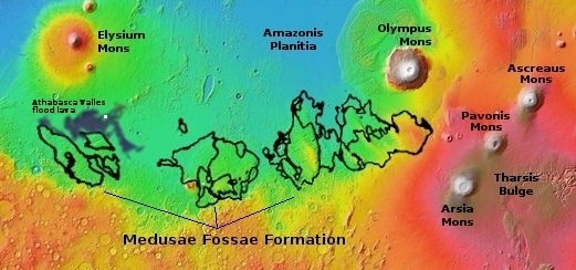
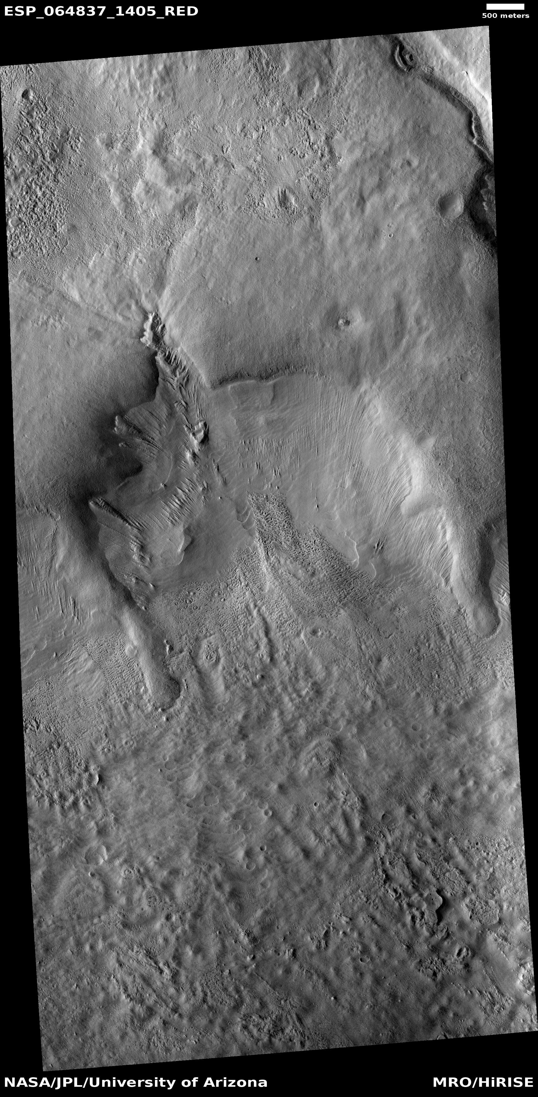
Whatever caused the meandering canyons on Mars, whether glaciers or liquid water, it was a process that was long-lived and multi-staged, as indicated by today’s cool image to the right, rotated, cropped, and reduced to post here. This photo, taken on June 28, 2020 by the high resolution camera on Mars Reconnaissance Orbiter (MRO), shows a large canyon cutting downward from a high ridgeline to the north. As that canyon begins to flow out out of the mountains and into the plains to the south, a secondary inner channel appears, meandering down the center of the larger canyon.

This canyon is located at 35 degrees south latitude, in the mid-latitude region where scientists have found evidence of a lot of glaciers. In fact, there are some hints of eroded glacial material in the small channels to the west of this main canyon. Also, there appear to be patches of corroding glacial ice on the south-facing slopes of the east and west hills that define the main channel. In the canyon itself however there appear to be few if any glacial-type features.

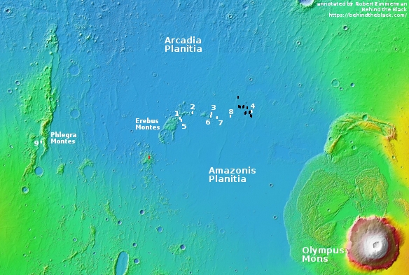
The overview map below gives the location context.
» Read more

0 comments

A hint of unexpected fresh ice on Enceladus

Two views of Enceladus
Click for full image.

Using data collected by Cassini while it orbited Saturn for thirteen years, scientists have found that there might be more relatively fresh ice on the surface of the moon Enceladus than previously believed.

Cassini scientists discovered in 2005 that Enceladus – which looks like a highly reflective, bright white snowball to the naked eye – shoots out enormous plumes of ice grains and vapor from an ocean that lies under the icy crust. The new spectral map shows that infrared signals clearly correlate with that geologic activity, which is easily seen at the south pole. That’s where the so-called “tiger stripe” gashes blast ice and vapor from the interior ocean.

But some of the same infrared features also appear in the northern hemisphere. That tells scientists not only that the northern area is covered with fresh ice but that the same kind of geologic activity – a resurfacing of the landscape – has occurred in both hemispheres. The resurfacing in the north may be due either to icy jets or to a more gradual movement of ice through fractures in the crust, from the subsurface ocean to the surface.

The image above, cropped, reduced, and rearranged to post here, shows two views of Enceladus. On the left we are looking at one hemisphere, with the south pole at the bottom. On the right we are looking straight down at the south pole. The red areas are where scientists think there is relatively fresh ice. While the new ice is very pronounced at the south pole, where the tiger-striped vents have been found, the northern ice is much less evident, though clearly there.

That northern fresh ice however might not come from the planet’s interior, as suggested by the press release. It might also be new ice deposited from space that came from those very active tiger stripes. At the present time the data doesn’t allow for any solid conclusions.

0 comments

Martian crater filled with lava

Lava filled Martian crater
Click for full image.

Cool image time! Unlike most of the recent images I’ve posted from Mars, today’s has nothing glacial about it. Instead, the photo to the right, cropped to post here, shows us a crater where lava broke through the southern rim to fill its interior.

The picture was taken on July 15, 2020 by the high resolution camera on Mars Reconnaissance Orbiter (MRO). The crater is located within what I call volcano country on Mars, just inside the Athabasca Valles lava field, what some scientists believe [pdf] is the youngest lava field on Mars, estimated have occurred less than 600 million years ago.

The overview map below provides context.

Overview map

The tiny white box south of Elysium Mons indicates the location of this crater. The dark blue areas indicate the extent of the Athabasca lava field. The Medusae Fossae Formation is the largest volcanic ash deposit on Mars.

The Athabasca lava field is about the size of Great Britain, and is thought to have been laid down in only a matter of a few weeks. When it spread it clearly reached this crater, the lava pushing through to fill it. If you look at the full image you can see that the north-trending lava flow even continued past the crater a considerable distance on both sides, the crater acting like a big rock in a stream, blocking the flow.

Since this happened more than half a billion years ago, a lot of erosion has occurred, mostly between the crater’s rim and the edge of the ponded but now solidified lava.

0 comments

Unexplored Mars

Strange crater on the edge of Argyre Basin
Click for full image.

The constant stream of images and data that our orbiters and landers are feeding down to us from Mars can sometimes give the impression that the red planet is being thoroughly explored. Today’s cool image illustrates how this impression is false, and instead shows a hint of what remains untouched on the fourth planet from the Sun, a planet with the same land area as on Earth.

The photo to the right, cropped and reduced to post here, was taken by the high resolution camera of Mars Reconnaissance Orbiter (MRO) on May 10, 2020, and shows a strange crater on the north interior edge of Argyre Basin, one of Mars’ largest basins located in the southern hemisphere. Not as deep or as large as Hellas Basin, what I call the basement of Mars, Argyre is still the second largest such basin on Mars, about 1,100 miles in diameter with its lowest elevation 17,000 feet below the surrounding southern cratered highlands. Like Hellas, it is thought to be the remains of major impact.

The point of this post is not to try to explain the geology of this crater. Located at 45 degrees south latitude, it might or might not be showing us glacial evidence. The nature of the terrain is inconclusive. To figure out the geology here would require a lot more data, and a focused interest in studying it.

Instead, this image shows us how little we know of Mars. For example, this photo was not requested by any scientist doing specific research. It was requested instead by the science team for MRO’s high resolution camera because they need to take images at regular intervals to maintain the camera’s temperature, and if no one has requested an image for a specific time period, they make their own choice, picking a spot that might be interesting without knowing sometimes what they might find. Often such “terrain sample” images are somewhat boring. Other times they reveal some surprisingly interesting geology.

The map below gives a sense of how little of the Argyre Basin has been explored by MRO’s high resolution camera.
» Read more

3 comments

The frozen and changing mid-latitudes of Mars

Glacial erosion on Mars
Click for full image.

Using “frozen” and “changing” to describe any single location might seem contradictory, but when it comes to the mid-latitudes of Mars, high resolution images keep telling us that both often apply, at the same time and at the same place.

The photo to the right, rotated, cropped, and reduced to post here, is a typical example. Taken on May 8, 2020 by the high resolution camera on Mars Reconnaissance Orbiter (MRO), it shows what the scientists label as “mesas and ridges.” Drainage is to the south, and it sure looks like some sort of glacial flow is working its way downward within the canyons between those mesas.

Overall the terrain has the appearance of a frozen ice sheet, or at least terrain that has a shallow ice table close to the surface. It also looks like chaos terrain in its infancy, the erosion process not yet cutting down enough to make the mesas stand out fully.

The location of these mesas and ridges is shown in the context map below, which also shows that this location is at the same latitude as SpaceX’s Starship prime Martian landing site, and only about 400 to 500 miles to the east.
» Read more

0 comments

The alien Red Planet and the scientific method

Spiders, dunes, and strange terrain in high latitude southern Martian crater
Click for full image.

As a child growing up in the 1950s and 1960s and an avid reader of science fiction, I was constantly presented with stories about Mars and what people imagined it was like. At the time no spacecraft had as yet gotten a close look at the planet, so the theories of a desert planet, with many canals built by an alien race attempting to stave off death as the planet’s water disappeared, were still considered possible. So were theories that the changing colors across its surface seen seasonally in ground-based telescopes suggested the possibility of some form of lichen-like life that came and went with the seasons.

None of those fantasies have turned out to be true. All attempted to create an alien planet in the model of Earth, and thus were guaranteed to get it wrong. After a half century of increasingly sophisticated research, we now know a bit more about what Mars is like, and have learned that it is much stranger than we had imagined, an icy world quite possibly shaped by slowly shifting glaciers and ice sheets, creating surface features in ways so alien from what we are familiar with on Earth that even now scientists struggle to figure those processes out.

The photo above and to the right, taken on May 25, 2020 by the high resolution camera on Mars Reconnaissance Orbiter (MRO), is a perfect example. At first glance it fits what I call a “what the heck?” image. Without knowing more, it is impossible to figure out what we see here.

The wider image below, taken by context camera on MRO, provides our first clue.
» Read more

4 comments

Sharp Martian ridges sticking up from the dust

Sharp ridges sticking up from Martian dust
Click for full image.

Today’s cool image brings us back to the region of Mars where the rover Opportunity journeyed. Taken on June 25, 2020 by the high resolution camera on Mars Reconnaissance orbiter (MRO), the photo to the right, cropped and reduced to post here, focuses on some sharp but low ridges that appear to stick up out of the Martian dust, hinting that they are the tops of some larger feature buried over the eons and only now revealed partly by recent erosion. I estimate that their height is roughly one to two hundred feet or so.

This image is in Arabia Terra, the widest and largest transitional zone region between the northern lowland plains and the southern cratered highlands. It is also only about 200 miles north of where Opportunity landed, and about 230 miles from where it died after almost fifteen years of operation, on the west rim of Endeavour Crater. The overview map below gives the context.
» Read more

2 comments

A Martian starburst spider

A Martian starburst spider
Click for full image.

Cool image time! The photo to the right, cropped to post here, illustrates an example of a wholly unique Martian phenomenon, that is not only unique to Mars but is also found only in its south polar regions. The image was taken on July 17, 2020 by the high resolution camera on Mars Reconnaissance Orbiter (MRO).

What we are looking at is a permanent spider formation etched into the layered deposits of ice and dirt that cover the widest area surrounding Mars’ south pole. The blue dot just north of Chasma Australe on the overview map below shows the location of these starbursts, on those layered deposits.

Each winter the poles of Mars are blanketed with a thin mantle of dry ice, generally less than six feet thick. When spring arrives and sunlight hits this mantle, it heats the ice and sand on which the mantle lies, and that warmth causes the mantle’s base to sublimate back into gas. Eventually gas pressure causes the mantle to crack at its weak points so the gas can escape. By the time summer arrives that mantle is entirely gone, all of it returning to the atmosphere as CO2 gas.

This sublimation process differs between the north and south pole, due to the different terrain found at each. In the north the mantle mostly lies on ice or sand dunes, neither of which is stable over repeated years. Thus, the mantle weak points do not occur at the exact same place each year, even though they occur at the same type of locations, such as the base and crests of dunes.
» Read more

8 comments

Bennu tosses particles from its surface routinely

Objects ejected from Bennu
Tracked particles after August 28, 2019 ejection event.

During OSIRIS-REx’s more than twenty months flying close to the Bennu, scientists have found that the asteroid routinely kicks particles from its surface into space, with these events linked to the asteroid’s day-night cycle.

Since arrival the scientists have seen and tracked more than 300 ejection events, with the almost seven hundred objects detected ranging from about an eighth to a half inch in size. Most moved about eight inches per second, comparable to “a beetle scurrying across the ground.”

The image to the right, cropped, reduced, and brightened to post here, comes from the introductory paper of a suite of papers on the subject, published today.

The timing of the events however reveals the most.

As Bennu completes one rotation every 4.3 hours, boulders on its surface are exposed to a constant thermo-cycling as they heat during the day and cool during the night. Over time, the rocks crack and break down, and eventually particles may be thrown from the surface. The fact that particle ejections were observed with greater frequency during late afternoon, when the rocks heat up, suggests thermal cracking is a major driver. The timing of the events is also consistent with the timing of meteoroid impacts, indicating that these small impacts could be throwing material from the surface. Either, or both, of these processes could be driving the particle ejections, and because of the asteroidโ€™s microgravity environment, it doesnโ€™t take much energy to launch an object from Bennuโ€™s surface.

The link includes a cool movie showing the ejections events and the tracked paths of the ejected particles.

4 comments

Another pit on Mars!

Isolated small pit on Mars
Click for full image.

It has been several months since my last Martian pit update, mostly caused by the lack of new pit images coming down from the high resolution camera on Mars Reconnaissance Orbiter (MRO). I think this lack is not because of a lack of additional pits or caves but instead signals the completion of a first high resolution survey of the known pits so far found on Mars. A full list of all past pit updates can be found at the bottom of this post.

Regardless, the image to the right, cropped to post here, is the only such image in months, taken on April 14, 2020, and shows a small isolated pit in the lava slopes between the giant volcanoes Arsia and Pavonis Mons. In the full photograph you can see how isolated is this pit. To the limits of the image there are no other such features, the terrain a relatively smooth plain with only some small ridges and and a scattering of what seem to be partly obscured or eroded small craters.

The overview below map shows this pit’s relationship to the volcanoes as well as to all other known nearby pits.
» Read more

1 comment

Strange glacial flow features on Mars?

Flow features in Reull Vallis
Click for full image.

Cool image time! The photo to the right, rotated, cropped, and reduced to post here, was taken by the high resolution camera on Mars Reconnaissance Orbiter (MRO) on May 26, 2020, and shows what the scientists dub “Flow features in Reull Vallis.”

These features are typical in the mid-latitudes, and once again suggest the presence of buried glacial ice. The two lobes on the left and right both evoke such flows, as does the material in the drainage channel near the top of the photo.

What is more intriguing however are the strange features in the box. Below is that section, at full resolution.
» Read more

0 comments

The icy Erebus Mountains near where Starship will land on Mars

Overview of all SpaceX images in Arcadia Planitia

Glacial filled crater in Erebus Montes
Click for full image.

It has been several months since I posted any new photos of the region on Mars which SpaceX considers its prime candidate landing site for its Starship spacecraft/rocket, now under development. The map to the right shows the location of all the images that SpaceX has obtained from the high resolution camera on Mars Reconnaissance Orbiter (MRO) of this landing region, located in the northern lowland plains at the border between Arcadia and Amazonis and to the east of the Erebus Mountains. (See my post on November 13, 2019 for an analysis of the reasoning for SpaceX to choose this region, along with links to each of the numbered images.)

Time to take another look, this time at the very center of the southern cluster of the Erebus mountains. The crater to the right, its location indicated by the tiny red rectangle on the map above, was taken by MRO on May 6, 2020, and shows the typical glacial features scientists find in mid-latitude Martian craters. The floor appears filled with glacial material, with the repeated cyclical flows repeatedly coming down off the north-facing interior rim. That rim would generally be colder and get less sunlight, so snowfall is more likely to pile up there and then flow downward like a glacier, only to sublimate away once it moves out of shadow.

What makes these mountains enticing, only about 400 miles from the Starship landing zone, is not simply what is inside this crater, but what surrounds it. Below is the wider view provided by MRO’s context camera.
» Read more

1 comment
1 106 107 108 109 110 157