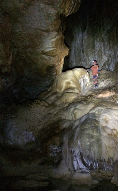
InSight resumes limited science operations

InSight on February 5th resumed science operations, reactivating its seismometer to record Martian quakes.

As I suspected in my previous InSight update, the lander’s life is still coming to an end.

The mission, though, has been grappling with a gradual decline in the spacecraft’s power because of dust accumulating on its solar arrays. Unlike the Spirit and Opportunity rovers, whose arrays were regularly cleaned by atmospheric activity, dust has continued to accumulate on InSight’s arrays. At a meeting of MEPAG in June 2021, Banerdt projected that power levels would drop below that needed to keep the spacecraft alive in the spring of 2022.

That date has been pushed out slightly, but he said the long-term outlook for the lander still does not look promising. “Our current projections indicate that the energy will drop below that required to operate the payload in the May/June time frame and probably below survivability some time near the end of the year,” he said.

They might still squeeze a month or two more from the lander, but unless they are very lucky and a dust devil blows across it, the end is coming.

1 comment

Alien and barren Mars

Curiosity's view looking to northeast, sol 3376 (February 4, 2022)
Click for full resolution. Click here, here, and here for original images.

Overview map
Click for interactive map.

Cool image time! The panorama above was created from three photos downloaded today from Curiosity’s right navigation camera. It looks to the northeast of the rover, out across Gale Crater. The crater floor is about 1,750 feet lower.

This is dust season on Mars, which explains the thick haze in the crater. About 25 miles away the crater rim can be faintly seen through the dust haze as a mountain chain. If you look at the full resolution panorama you can see several buttes on the crater floor barely visible through that haze.

The map to the right gives the context. Curiosity’s present location is indicated by the yellow dot, with the yellow lines indicating the area covered by the panorama. The red dotted line indicates the rover’s future planned route.

For the last few weeks Curiosity has been working nestled to the base of a small butte the science team has dubbed “The Prow”, studying its numerous thin layers. I featured the Prow in this January 11th post, though at the time I overestimated its size, which is only about ten feet high. The butte is especially fascinating in that its top layers overhang outward in an unbelievable manner.

The rover is now about to move on, though where must still be decided by the science team. Based on their most recent update it appears they are not ready to leave this barren rocky hollow surrounded with many-layered buttes, and will take the rover to another.

3 comments

Hot spot in northern Martian crater?

Hot spot in northern Martian crater?
Click for full image.

Cool image time! The photo to the right, rotated, cropped, and reduced to post here, was taken on September 22, 2021 by the high resolution camera on Mars Reconnaissance Orbiter (MRO). It shows an unnamed four-mile-wide crater in the high northern lowland plains of Mars, at 60 degrees north latitude.

At 60 degrees latitude, it is likely that the crater’s interior is filled with buried glacial ice. A close look at the crater’s interior rim shows that whatever material fills the crater does not quite reach the rim. Furthermore, there are areas in the interior where it appears some slight sublimation has occurred. These features suggest the interior material is buried ice, but do not prove it.

What makes this crater intriguing however is the irregular depression at its center. When craters have a feature at the center, it usually is a central peak, caused at impact. The impact makes the ground act like a pond of water when you drop a pebble into it, with circular ripples (the crater rim) spreading outward and an uplift in the center (the central peak). In the case of a crater, the pond quickly freezes, locking those ripples and uplift in place.

Why a central depression then?
» Read more

8 comments

When looking at Mars’ images you must never jump to conclusions

Hardened sand in a crater
Click for full image.

In the past four years I have posted hundreds of cool images taken by the orbiters circling Mars. From those images I have been able to slowly gather and pass on to my readers some of the solid knowledge that scientists are gaining now about the Red Planet.

The image to the right illustrates best why one must never make any quick assumptions about the features you see in these photos. Taken on November 28, 2021 by the high resolution camera on Mars Reconnaissance Orbiter (MRO), it shows a small crater that appears partly filled with material. On its walls can be seen many slope streaks, a still unexplained feature unique to Mars that is not caused by rock or debris avalanches.

As for the material inside the crater, based on the majority of Martian images showing similar craters, the first assumption one might make is that this material is some form of eroding glacial material.

That first assumption however would simply be wrong. Glacial material found in Martian craters is routinely found in the mid-latitude bands between 30 and 60 degrees. This crater is sits almost exactly on the equator of Mars, where scientists have found no evidence of any glacial material or near-surface ice. In the equatorial regions the surface of Mars is essentially dry.

So what is that patch of material? As always, location is all.
» Read more

2 comments

Glaciers in the Phlegra Mountains on Mars

Glaciers in the Phlegra mountains
Click for full image.

Cool image time! The photo to the right, cropped to post here, is just one of the many hundreds taken by the high resolution camera on Mars Reconnaissance Orbiter (MRO) as well as Europe’s Mars Express orbiter showing the thick icy glacial flows that surround practically every mountain or hill in the Phlegra mountains of Mars.

This picture was taken on November 3, 2021, and shows the eroding foot of an eroding glacial flow coming down from a small hill in a southeastern part of these mountains dubbed Phlegra Dorsa. The downward grade is to the north.

At 30 degrees north latitude it is not surprising these glacial flows are eroding, as they are at the southernmost limit of the mid-latitudes bands where such glaciers are found. Closer to the equator scientists have yet to find much evidence of ice.

The repeating arcs at the foot of this glacier suggest that it pushed downward in cycles, with each later cycle traveling a shorter distance. This supposition makes sense, considering scientists think the ebb and flow of these Martian glaciers has been determined by the cyclical changes in the planet’s rotational tilt.

The overview map below not only gives the context, it shows this location relative to the candidate landing sites for SpaceX’s Starship spacecraft.
» Read more

7 comments

Scientists: Liquid surface water might have existed on Mars as recently as 2.3 billion years ago

Map showing locations of salt deposits
Click for full image.

Using orbital data from Mars Reconnaissance Orbiter (MRO), scientists have found salt deposits on Mars where nearby crater counts suggest that the salt water that once held these deposits could have evaporated away as recently as 2.3 billion years ago.

Using [MRO’s] cameras to create digital elevation maps, Leask and Ehlmann found that many of the salts were in depressions – once home to shallow ponds – on gently sloping volcanic plains. The scientists also found winding, dry channels nearby – former streams that once fed surface runoff (from the occasional melting of ice or permafrost) into these ponds. Crater counting and evidence of salts on top of volcanic terrain allowed them to date the deposits.

Past data has suggested that if liquid surface water had existed on Mars, it was gone by three billion years ago.

You can read the scientists’ research paper here.. The maps to the right, figure two from the paper, shows the locations of discovered salt deposits, almost all of which are in the Martian southern cratered highlands of Mars.

Is there uncertainty in these results? My regular readers know that the answer is of course yes. The biggest problem for these Mars researchers is that, despite the surface evidence that liquid water should have once flowed on the surface of Mars, no scientist has yet come up with a satisfactory model of Mars’ past climate that would have made that possible. The planet was either too cold or had too thin an atmosphere, based on other data. And getting it warmer or with a thicker atmosphere involves inventing any number of scenarios that are all questionable, based on what is presently known.

There is also the increasing evidence that glaciers of ice, not water, might have carved those winding, dry channels. If so, many of the assumptions that liquid water existed might simply be wrong, or incomplete. The scientists who wrote this report recognize this importance of ice on Mars, and note in their abstract that

…we think that the water source came from surface runoff, rather than deep groundwater welling up to the surface. The small amounts of water required are most likely from occasional melting of ice.

As always, more data is needed, with the most useful data that will clarify these conclusions being that gathered by future colonists on the surface of Mars itself.

8 comments

Mars’ youngest lava flow

Mars' youngest lava flow
Click for full image.

Today’s cool image is in some ways another version of my last cool image yesterday. Both are in Mars’s volcano country. Both show what appears to be a lava flow.

Yesterday’s image showed the leftover evidence of a confined flow of lava running in a meandering pattern like a river, and was somewhat distant from the biggest nearby volcanoes. Today’s cool image, to the right and rotated, cropped, and reduced to post here, is instead located smack dab on the inside of what is thought to be Mars’ youngest major lava event, the Athabasca flood lava plain, and in fact is near its outlet, when about 600 million years ago it belched out enough lava in just a matter of a few weeks to cover an area about the size of Great Britain.

The overview map below illustrates this.

» Read more

0 comments

U-shaped meandering Martian ridge

Broad U-Shaped meandering ridge on Mars
Click for full image.

Cool image time! The photo to the right, rotated, cropped, and reduced to post here, was taken on December 3, 2021 by the high resolution camera on Mars Reconnaissance Orbiter (MRO). It shows what the scientists label a “Broad U-Shaped Ridge”. The two black squares are merely areas where no data was gathered.

Is this a fossilized river, of which scientists have identified more than 10,000 in the Arabia Terra transition region between the northern lowland plains and the southern cratered highlands? Arabia Terra however is literally on the other side of Mars, very far away.

The location, as shown in the overview map below, instead suggests that, if this U-shaped meander is a fossilized river, it isn’t one created by water or ice.
» Read more

1 comment

Another study says Mars does not have liquid water under its south pole

The uncertainty of science: A new study now claims that the presumed detection of lakes of liquid water under the Martian southern polar ice cap in 2018 was likely wrong, and that the detection was more likely volcanic rock.

The researchers think their conclusion — volcanic rock buried under ice — is a more plausible explanation for the 2018 discovery, which was already in question after scientists calculated the unlikely conditions needed to keep water in a liquid state at Mars’ cold, arid south pole.

“For water to be sustained this close to the surface, you need both a very salty environment and a strong, locally generated heat source, but that doesn’t match what we know of this region,” says the study’s lead author, Cyril Grima, a planetary scientist at The University of Texas at Austin Jackson School of Geosciences.

So my readers know how uncertain all of this is, note that the 2018 discovery of underwater liquid water was later confirmed by other scientists in 2020, then rejected by different researchers in 2021, who claimed it was clay instead.

In other words, the scientists have some inconclusive data that could mean many different things, either water, clay, volcanic rock, or maybe something else that someone hasn’t yet suggested. To really answer the question will require far more data, with some like required in situ on Mars itself.

2 comments

Confirmed: All debris cleared from Perseverance sample tube

Mosaic showing the clearing of debris
Click here and here for original images.

The Perseverance science team today announced in an update that their effort to clear the sample tube of bits of core sample has succeeded, as indicated partly by the two images above that I posted on January 19th.

According to the report, the two small pieces visible bottom center fell out after two small rotations of the carousal. Other pieces however remained, and these were removed as followed:

On Monday, Jan. 17, the team commanded another operation of the rotary percussive drill in an attempt to dislodge more material from the tube. With the tube’s open end still pointed towards the surface, we essentially shook the heck out of it for 208 seconds – by means of the percussive function on the drill. Mastcam-Z imagery taken after the event shows that multiple pieces of sample were dumped onto the surface. Is Tube 261 clear of rock sample? We have new Mastcam-Z images looking down the drill bit into the sample container that indicate little if any debris from the cored-rock sample remains. The sample tube has been cleared for reuse by the project.

The team is now discussing their next step, which could be drilling a new hole at this spot or moving on.

1 comment

Contact restored with InSight after dust storm

The InSight science team has regained communications with the lander on Mars following a dust storm that caused it to shut down all operations entirely.

Though the tweet from the science team says the space craft is out of safe mode, that really doesn’t appear to be the case. Safe mode is a condition where a robot ceases all science operations, hunkers down, and awaits further orders. All that has happened here is that the engineers have regained contact after communications were lost on January 7th. No science is being done.

The resumption of communications is excellent news, however. They must now access how much power the lander’s solar panels are generating to see if they can turn InSight’s main instrument, its seismometer, back on. Those panels might be badly covered with dust, preventing operations.

5 comments

Freaky badlands on Mars

Freaky badlands on Mars
Click for full image.

Cool image time! The photo to the right, rotated and cropped to post here, was taken on November 18, 2021 by the high resolution camera on Mars Reconnaissance Orbiter (MRO). Labeled merely as “Danielson Crater Outcrops,” it shows us a perfect example of the strangeness and sometimes very forbidding terrain of Mars.

We are looking at the outcrop tops of many tilted layers, worn into curves semicircles with the convex side all pointing to the southwest. In the hollowed concave-side, dust and sand have accumulated and been trapped, sometimes forming small ripple dunes when there is enough space for the wind to get inside, as seen in the picture’s lower right.

Danielson Crater is 41 miles in diameter. The overview map below provides the context.
» Read more

4 comments
1 80 81 82 83 84 157