Geological maps of Vesta published
The scientists who used Dawn to map Vesta have now published detailed geological maps of the large asteroid.
More here.
The scientists who used Dawn to map Vesta have now published detailed geological maps of the large asteroid.
More here.
An Italian appeals court on Monday overturned the manslaughter convictions of six Italian earthquake scientist for the deaths of over 300 people during the L’Aquila earthquake of 2009.
Only one of the seven experts originally found guilty was convicted today: Bernardo De Bernardinis, who in 2009 was deputy head of Italy’s Civil Protection Department and who will now serve 2 years in jail, pending any further appeals.
De Bernardinis had been the guy who had publicly said that the swarm of tremors prior to the quake had released energy and thus reduced the chance of an earthquake, a claim that geology scientists do not support.
Spectroscopy from Curiosity’s most recent drilling has been found to match and thus confirm the spectroscopy of the same spot taken years ago from orbit.
In observations reported in 2010, before selection of Curiosity’s landing site, a mineral-mapping instrument on NASA’s Mars Reconnaissance Orbiter provided evidence of hematite in the geological unit that includes the Pahrump Hills outcrop. The landing site is inside Gale Crater, an impact basin about 96 miles (154 kilometers) in diameter with the layered Mount Sharp rising about three miles (five kilometers) high in the center.
“We’ve reached the part of the crater where we have the mineralogical information that was important in selection of Gale Crater as the landing site,” said Ralph Milliken of Brown University, Providence, Rhode Island. He is a member of Curiosity’s science team and was lead author of that 2010 report in Geophysical Research Letters identifying minerals based on observations of lower Mount Sharp by the orbiter’s Compact Reconnaissance Imaging Spectrometer for Mars (CRISM). “We’re now on a path where the orbital data can help us predict what minerals we’ll find and make good choices about where to drill. Analyses like these will help us place rover-scale observations into the broader geologic history of Gale that we see from orbital data.”
This is a significant finding. Not only does this data now prove that the orbital data is correct, it demonstrates that scientists can now use that orbital data to direct Curiosity to even more interesting geological surface features. In fact, this ground-based data will help them calibrate all their orbital data more precisely, thus making our geological knowledge of Mars more accurate and reliable.
New data suggests that when a large impact hit Vesta’s Rheasilvia basin sometime in the past, the entire asteroid was shaken up, producing ripples that eventually surfaced as the giant grooves that circle the asteroid’s equator.
“Vesta got hammered,” said Peter Schultz, professor of earth, environmental, and planetary sciences at Brown and the paper’s senior author. “The whole interior was reverberating, and what we see on the surface is the manifestation of what happened in the interior.”
The research suggests that the Rheasilvia basin on Vesta’s south pole was created by an impactor that came in at an angle, rather than straight on. But that glancing blow still did an almost unimaginable amount of damage. The study shows that just seconds after the collision, rocks deep inside the asteroid began to crack and crumble under the stress. Within two minutes major faults reached near the surface, forming deep the canyons seen today near Vesta’s equator, far from the impact point.
Essentially, for a very very short period of time, immediately after the impact, the solid material of the asteroid acted more like a liquid, producing ripples that immediately settled down as the solid deep equatorial grooves we see today.
A new look at old data of Venus has added weight to the theory that the planet’s higher elevations are coated with a frost of heavy metals.
The research not only confirmed a radar brightening at higher altitudes, thus suggesting a frost coating of some kind, it also showed many dark spots whose cause remains completely unknown. As the article notes,
Years ago it was proposed that some sort of ferro-electric compound might be the cause of the brightening and the dark spots, but so far no specific compound has been identified which does the trick. Then again, with the surface of Venus being at almost 900 °F (500 °C) under more than 90 times the air pressure of Earth’s atmosphere at sea level, with occasional showers of acid, it’s not easy to test the properties of materials under Venusian conditions. “No one knows what explains the sudden darkness,” said Harrington, who will be presenting the work at the meeting of the Geological Society of America in Vancouver, B.C., on Monday, Oct. 20.
By reanalyzing the data that had recorded the fireball twenty years ago, a team of meteorite hunters in the Czech Republic have finally located the remains of a meteorite that landed in 1991 but could not be found.
What is most interesting scientifically about their find is that the pieces they found were from different types of meteorites.
[T]hese four meteorites are of three different mineralogical types. This means that the Benešov meteoroid was heterogeneous and contained at least three different types of material. After the Almahata Sitta fall, this is the second time that such a heterogeneous composition has been found. It raises the possibility that a significant fraction of all asteroids are heterogeneous and that they were strongly reprocessed by collisions with other asteroids in the main belt.
In other words, the meteorite had been a conglomerate of different geological types, which were created in different environments and were later smashed together to form this one rock.
New data from Lunar Reconnaissance Orbiter suggests that lunar volcanism petered out slowly and occurred more recently that previously believed.
NASA’s Lunar Reconnaissance Orbiter (LRO) has provided researchers strong evidence the moon’s volcanic activity slowed gradually instead of stopping abruptly a billion years ago. Scores of distinctive rock deposits observed by LRO are estimated to be less than 100 million years old. This time period corresponds to Earth’s Cretaceous period, the heyday of dinosaurs. Some areas may be less than 50 million years old. Details of the study are published online in Sunday’s edition of Nature Geoscience. “This finding is the kind of science that is literally going to make geologists rewrite the textbooks about the moon,” said John Keller, LRO project scientist at NASA’s Goddard Space Flight Center in Greenbelt, Maryland.
In a way, this new conclusion is an example of science discovering the obvious. It seems to me quite unlikely that volcanic activity on the Moon would have “stopped abruptly” under any conditions. That’s not how these things work.
New geological evidence suggests that glaciers once flowed in Mars’ largest canyon, Valles Marineris.
An evening pause: The detective story that solved the mystery of the moving rocks of Death Valley.
For a century, these eerie rocks and their long, graceful trails have stumped visitors and scientists. The boulders of black dolomite appear to move on their own, sliding uphill across the playa’s flat lakebed. The trails are the only evidence the rocks move. No one has ever seen them set sail.
Scientists have raised questions about the meteorite impact that was reported to have occurred in Nicaragua on Saturday.
More here. There are doubts about the impact crater, the theory that the meteorite was somehow related to the meteorite that flew past the Earth on Sunday, and the boom sound that local residents heard that same night.
A small meteorite hit the ground near Managua’s airport in Nicaragua on Saturday, creating a 39 foot wide crater.
By comparing data from the Voyager fly-bys of Saturn in the 1980s with new data collected by Cassini in the past decade scientists think they can now explain the changes that have occurred in Saturn’s outer F ring.
“The F ring is a narrow, lumpy feature made entirely of water ice that lies just outside the broad, luminous rings A, B, and C,” notes French. “It has bright spots. But it has fundamentally changed its appearance since the time of Voyager. Today, there are fewer of the very bright lumps.” The bright spots come and go over the course of hours or days, a mystery that the two SETI Institute astronomers think they have solved.
“We believe the most luminous knots occur when tiny moons, no bigger than a large mountain, collide with the densest part of the ring,” says French. “These moons are small enough to coalesce and then break apart in short order.”
The Rosetta science team has released their first geology map of Comet 67P/C-G, showing the nucleus’s surface divided into different kinds of terrain.
Scientists have found evidence that Jupiter’s moon Europa undergoes the same kind of plate tectonics seen on Earth.
American scientists have confirmed that water samples from the buried Antarctic Lake Whillans, first obtained in January 2013, contained almost 4,000 different species of life.
Samples from the lake show that life has survived there without energy from the Sun for the past 120,000 years, and possibly for as long as 1 million years. And they offer the first look at what may be the largest unexplored ecosystem on Earth — making up 9% of the world’s land area. “There’s a thriving ecosystem down there,” says David Pearce, a microbiologist at Northumbria University, UK, who was part of a team that tried, unsuccessfully, to drill into a different subglacial body, Lake Ellsworth, in 2013.
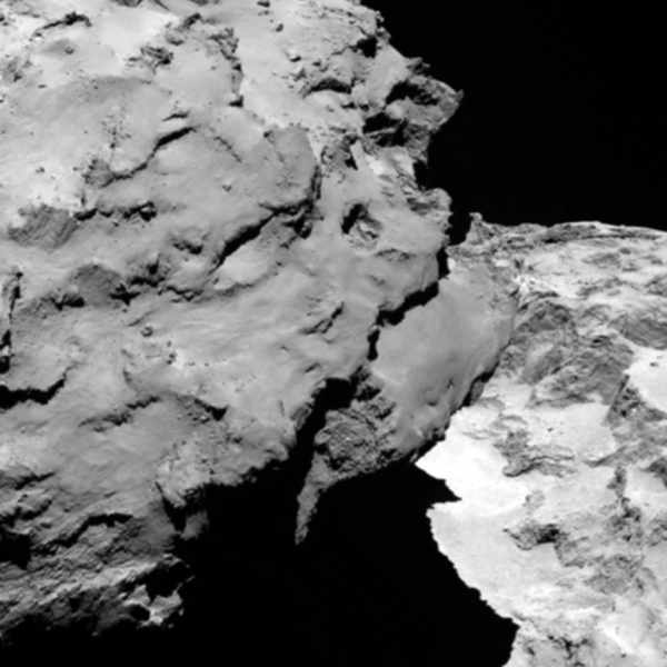
Rosetta has successfully achieved orbit around Comet 67P/C-G and has transmitted its first close up images. More information here and here about the rendezvous and what science the mission scientists plan to do as they orbit the comet.
The image below is looking down and past the comet’s smaller component as it casts a shadow on the neck and the larger component beyond. As with the earlier images, the comet’s pitted and corroded surface, lacking any obvious craters, is reminiscent to me of a pile of dirty snow that has been dissolving away. In fact, when I lived in New York I would see this kind of look every winter. When the city would get a big snowfall snowplows would push it into large mounds on the side of the road. As time passed these piles would get dirty from the city’s soot and grime, and also slowly melt away. After several weeks it would look almost exactly like the surface of Comet 67P/C-G.
The images and data that will come down from Rosetta over the next year and half as it orbits the comet in its journey around the Sun will be most fascinating. Stay tuned!
In 2013 the ground-based Gemini telescope imaged a gigantic volcanic eruption on Jupiter’s moon Io.
More here, including information on two other eruptions that occurred about the same time.
The uncertainty of science: A second look at cores drilled in the Pacific northwest has raised doubts about the previous conclusions that the region faces the threat of megaquakes every few centuries.
The bottom line is that though geologists are very confident the northwest faces the threat of future quakes, they can’t yet predict with any confidence their rate or intensity.
Using computer models based on the Moon’s crater record, scientists have developed a simulation of the great early bombardment of the Earth around 4 billion years ago.
The model suggests that the biggest asteroids to hit Earth would have been as large as 3,000 kilometres across. Between one and four would have been 1,000 kilometres wide or larger, it predicts, with a total of three to seven exceeding 500 kilometres in width. The most recent of these would have hit around 4.2–4.3 billion years ago.
In comparison with Earth’s mass, the amount of rock hitting the planet would have been tiny. But it would have had an enormous effect on Earth’s surface, says Marchi. A 10-kilometre-wide asteroid was enough to kill the dinosaurs, and studies4 show that one 500 kilometres across would vaporize all of the planet’s oceans. “At 1,000 kilometres, the effects would be so wide the planet would probably be completely resurfaced with material from the mantle,” he says.
More here, including animated gifs showing this bombardment unfold.
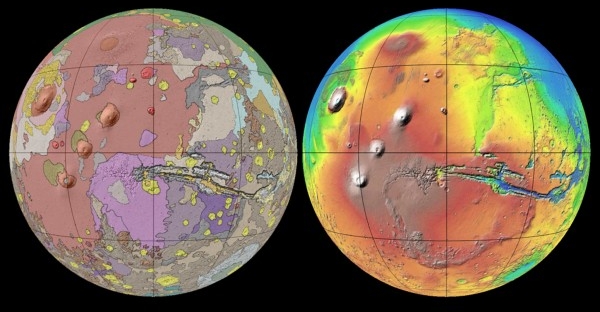
Scientists have released a new geological map of Mars based on data accumulated over the last sixteen years by four orbiters and four rovers.
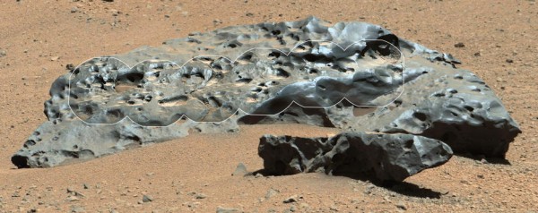
In related news, Curiosity has stumbled upon a six foot wide meteorite sitting on the surface of Mars.