Tag: geology
More caves on Mars
And damn, do I want to rappel into them!
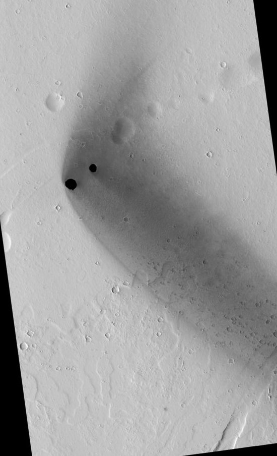
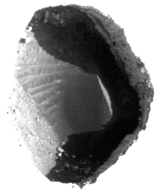
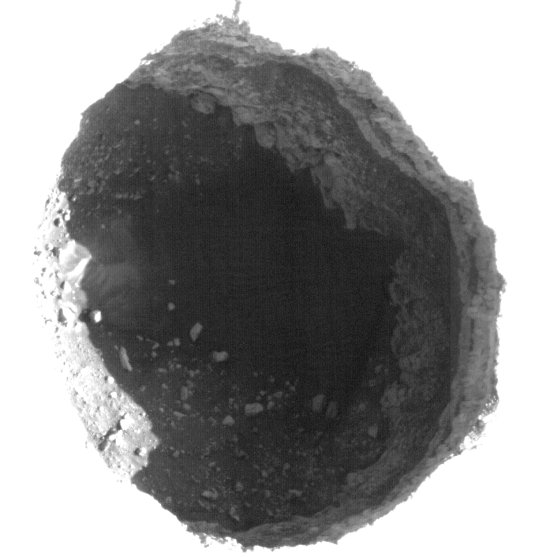
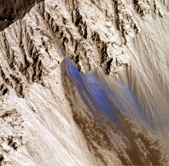
This week’s release of images from the HiRISE camera on Mars Reconnaissance Orbiter included these spectacular photos of two deep pits, approximately 180 and 310 meters in diameter and located aligned with a series of depressions that suggest additional passages at their base.
The first image shows the pits in the context of the surrounding terrain. From the caption:
These pits are aligned with what appears to be larger, degraded depressions. The wispy deposit may consist of dark material that has been either blown out of the pits or from some other source and scattered about by the local winds.
The next two images are heavily processed close-ups of each pit in order to bring out the detail within. From the caption:
The eastern most and smaller of the two pits contains boulders and sediment along its walls and brighter aeolian dune sediments on its floor. The larger, western most pit contains sediment and boulders with faint dune-like patterns visible on the deepest part of the floor. Both pits have steep eastern walls and more gently sloped western walls that transition gradually into the pit floor. Steep resistant ledges containing boulders that overhang and obscure the pit floors form the eastern walls.
Flash flood
An evening pause: Flash flood in the desert.
Indonesian eruption volcano continues
The eruption of Mount Merapi continues to build, with the death toll now over 150 and over 200,000 people displaced from their homes. Heavens, it might even cause President Obama to cancel his visit to Indonesia.
Update on Mount Merapi eruption
More on the continuing eruption of Mount Merapi in Indonesia. Key quote:
The Volcano Mitigation and Geological Disaster Agency warned of worse in store as magma pushed towards the surface from depths of 6-8km, compared with a maximum 2km deep when the mountain previously erupted in 2006. “This is the scenario I dislike the most, because the deepest magma is pushing up now,” said the agency’s chief, Surono. “The eruptions haven’t stopped, the tremors are getting stronger and one big explosion could be the result. I’ve never seen it act like this. We don’t know what to expect.”
Volcano eruption in Indonesia
The worst volcanic eruption of Mount Merapi in Indonesia in a century has gotten worse.
Thor’s well
Another Iceland volcano eruption pending?
Another Iceland volcano eruption pending? Iceland’s largest glacier, which sits atop the island’s largest volcano, Grimsvotn, began releasing large amounts of melt water on Thursday, October 25, indicating the volcano underneath might be heating up.
Evidence of subsurface water found by Mars rover Spirit
Evidence of subsurface water has been found by the Mars rover Spirit at the location where the rover remains stuck.
Tsunami and volcano hit Indonesia
Bad news from Indonesia: A tsunami killed 108 at the same time a volcano eruption has forced thousands to flee.
Evidence of active volcanoes on Venus
Scientists have detected Venusian lava flows possibly only decades old.
Two German radar mapping satellites to produce three-dimensional imagery of Earth
Two German radar mapping satellites, flying in orbital formation, are now about to produce the first three-dimensional radar imagery of Earth. Key quote:
The combined mission’s data will produce gridded maps with a spatial resolution of 12 meters, or 39 feet. The maps will show elevation with a precision of less than 2 meters, or 6 feet.
Eyjafjallajökull volcano, Iceland
An evening pause: Time lapse of the eruption of Eyjafjallajökull volcano, Iceland, April 19, 2010.
Recent landslide on Mars
Mars Reconnaissance Orbiter has taken this image of what appears to be a recent landslide on Mars, located on the southeast wall of Zunil crater. When the landslide took place is not known, though the color suggests that it happened so recently that the debris has not yet been covered by wind-blown dust.
Most Incredible Volcano Footage Ever
A evening pause: More volcanoes!
Mars’ geology suggests it once had rich carbon dioxide atmosphere
The discovery by scientists of carbonate rock deep below the Martian surface suggests the planet once had a rich carbon dioxide atmosphere. It also suggests that conditions might be more habitable for life deep underground.
It’s only a seltzer moon Plumes from Saturn’s Enceladus may be carbonated
The plumes that come out of the tiger stripe cracks on Saturn’s moon Enceladus may be carbonated!
Pluto’s ice: 97% nitrogen, 3% methane
More results from the press conference going on right now at the 42nd meeting of the AAS Division for Planetary Sciences:
Pluto’s surface ice is made up of 97% nitrogen, 3% methane, while the surface of the Kuiper Belt object Eris (which is larger than Pluto) is even more rich in methane, with a make up of 90% nitrogen and 10% methane. Both measurements go down to a depth of about 10 inches. To see the abstract for this result, go here.
No active volcanoes on Mars
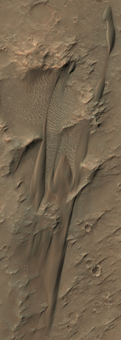
The wind-blown dunes of Mars
The HiRise Camera on Mars Reconnaissance Orbiter has released some wonderful new pictures, showing what are called barchan dunes on Mars.
Barchans are crescent-shaped, with the horns of the crescents pointing downwind. One barchan is visible in the upper part of the image, with the Southeast (lower right) horns longer than the other. This trend, along with the position of the steep face of the dune on the South side, indicates that the predominant winds which formed the dunes came from the North.
There are a lot more great images on the websites above.