Tag: geology
Tallest Known Cliff in the Solar System
Defiant Japanese boat captain rode out tsunami
Another hero: Defiant Japanese boat captain who rode out tsunami.
Neighbouring volcanoes on Mars
a giant potato in space
A statistical study says big quakes don’t trigger others far away
A new statistical study has concluded that big quakes don’t trigger others large quakes far away.
Nuclear Meltdown at Quake-Damaged Japanese Plant
This ain’t good: A nuclear meltdown appears to have occurred at the quake-damaged Japanese power plant.
Quake moved Japan coast 8 feet; shifted Earth’s axis
The earthquake moved Japan’s coast eight feet while shifting the Earth’s axis about four inches.
Panic buying as Hawaii and Pacific islands braced for killer waves to strike across thousands of miles of ocean
Hawaii and Pacific islands brace for killer tsunami waves to strike across thousands of miles of ocean.
More here about the situation in Japan.
Video:
Hawaii’s Kilauea volcano erupts with greater fury
Hawaii’s Kilauea volcano erupts.
Enceladus’s hotspot is far hotter than predicted
The tiger stripe fissures on Saturn’s moon Enceladus have turned out to be far hotter than predicted.
Drillers will stop injections for fear of earthquakes in Arkansas
Two drill companies will temporarily cease work in Arkansas to see if this action will cause the recent swarms of earthquakes there to ease.
Some unusual commercial caves
A look at some truly different commercial caves.
NASA’s chief technologist admits it will be a decade before Orion flies
This is why I call it pork and a waste of money: NASA’s chief technologist admits it will be a decade before Orion and the heavy-lift rocket mandated by Congress flies.
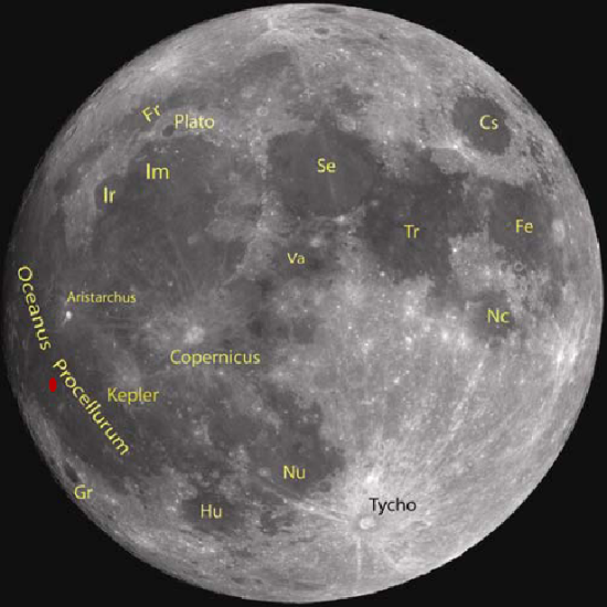
The caves of Copernicus
and the Ocean of Storms
The discovery of new caves on the Moon keep coming. Today I have two new stories. The first is a discovery by professional scientists of a giant lava tube cave in the Oceanus Procellarum or Ocean of Storms. The second is the detection of a plethora of caves and sinks on the floor of the crater Copernicus, found by a NASA engineer who likes to explore the gobs of data being accumulated by Lunar Reconnaissance Orbiter and made available to all on the web.
The image below of the Moon’s near side, taken by India’s Cartosat-2A satellite and taken from the science paper, shows the location of lava tube in Oceanus Procellarum (indicated by the red dot) and the crater Copernicus.
First the professional discovery. Yesterday, the Times of India reported the discovery of lava tube more than a mile long on the Moon. I did not post a link to the article because I didn’t think the news story provided enough information to make it worth passing along. Today however, fellow caver Mark Minton emailed me the link where the actual research paper could be downloaded [pdf]. This I find definitely worth describing.
» Read more
More on New Zealand quake
More on the New Zealand earthquake: Curfew imposed as death toll climbs to 75.
Thousands flee as Philippine volcano erupts
Thousands flee as Philippine volcano erupts.
The Earth’s shifting magnetic pole
More quakes in Arkansas, including a 4.3
The mysterious swarm of earthquakes in Arkansas keep coming, including a 4.3 quake today.
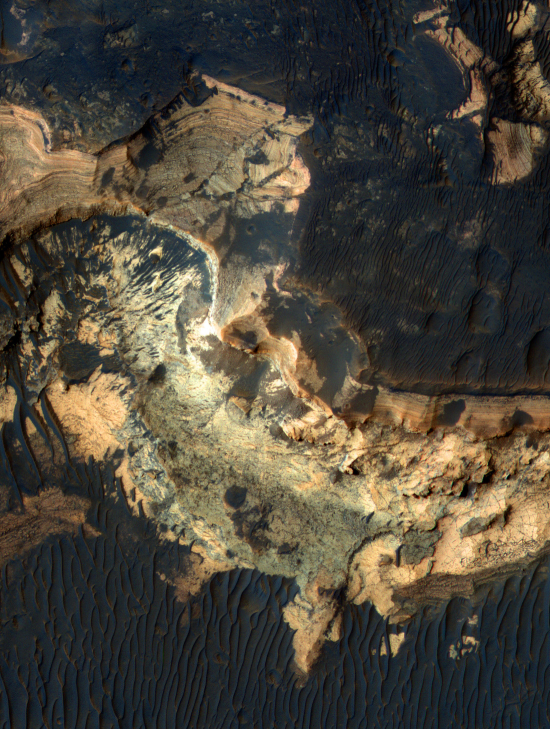
A potential landing site for next Mars rover
This week’s release of cool images from Mars Reconnaissance Orbiter included the color image below of a region on the floor of Holden Crater, one of the four possible landing sites for Curiosity, the Mars Science Laboratory planned for launch later this year. (If you want to see the entire image at higher resolution, you can download it here.)
Two things that immediately stand out about this image (other than this looks like an incredibly spectacular place to visit):