Plato Crater on the Moon

Plato Crater's west rim

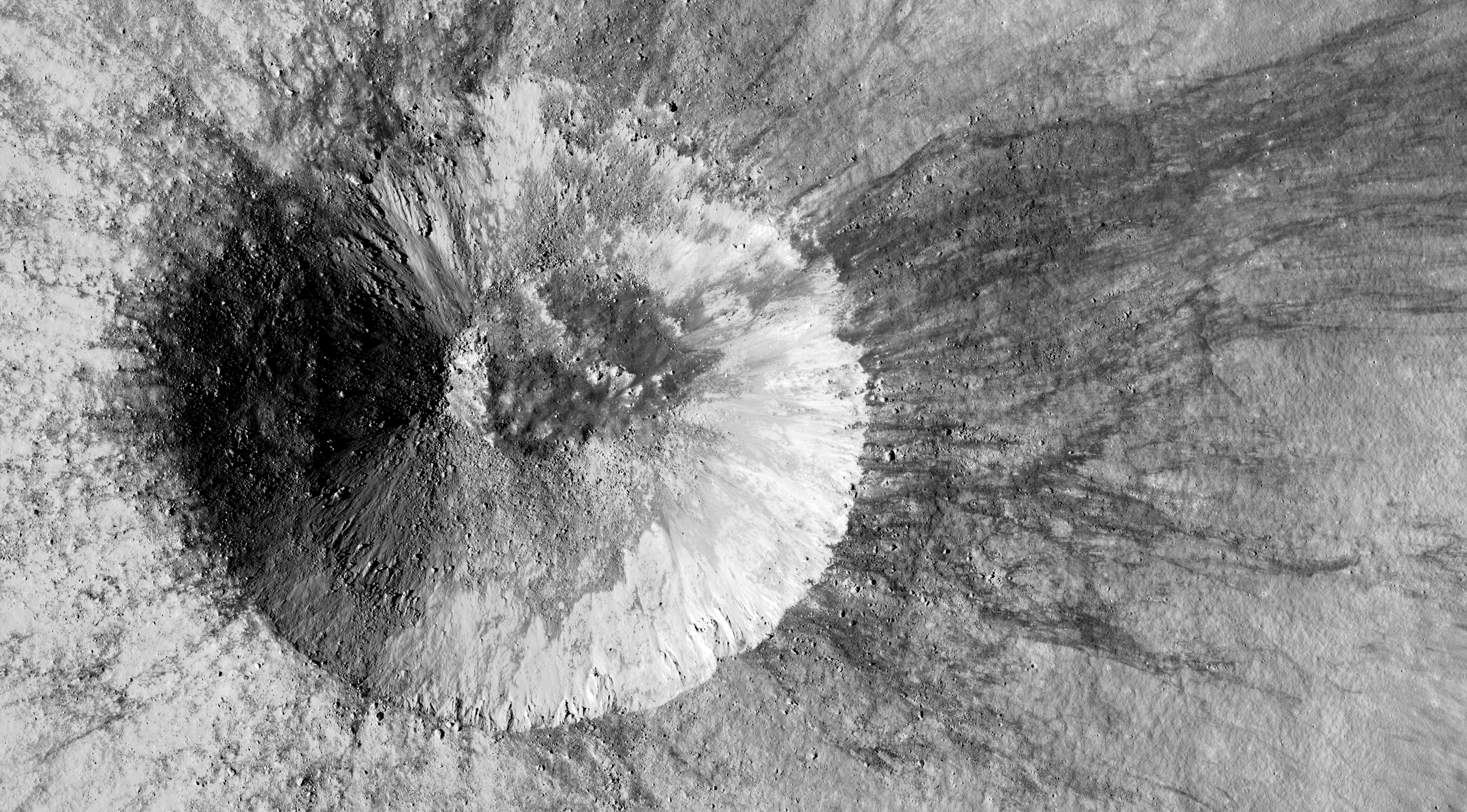
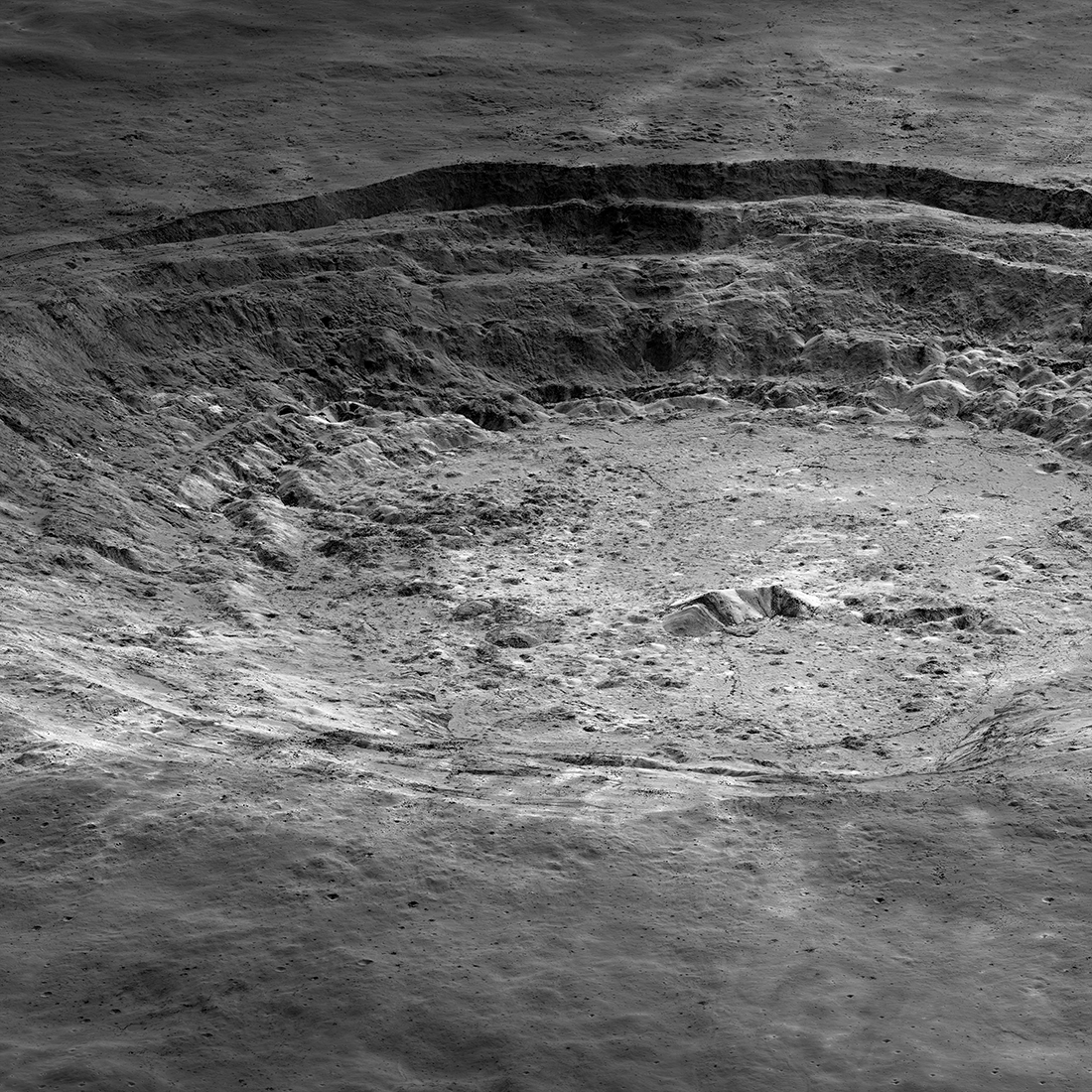
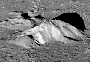
Cool image time! The Lunar Reconnaissance Orbiter (LRO) science team this week released a new high resolution image of the western rim of 63-mile-wide Plato Crater, located near the visible edge of the Moon’s near side. On the right is a slightly reduced version cropped to show the area of most interest.

Plato crater is prominent, yet from our vantage point on Earth we never truly see it as it is. That’s because it is located far enough north of the lunar equator (center latitude 51.62°N, center longitude 350.62°E) on the curving surface of the spherical Moon that it appears foreshortened. Plato is round like most other impact craters, but from Earth we see it as an oval aligned east to west.

A dark floor makes 101-kilometer-wide Plato crater stand out against a light-colored lunar highlands background. Plato crater is also prominent by association; the crater is located just north of 1145-kilometer-wide Mare Imbrium. A small part of this mare is visible at lower left in our Featured Image. Mare Imbrium is made up of many basalt layers laid down by violent volcanic episodes over a span of about 1.5 billion years. The basalts fill the Imbrium Basin, which a large asteroid or comet impact excavated about 3.85 billion years ago. When we look at a bright full Moon, round dark Mare Imbrium captures our gaze, then we see Plato crater, which is estimated to be about a hundred million years younger than the Imbrium Basin.

The western rim of Plato crater — visible on the east (right) side of our Featured Image — includes a 23.4-kilometer-wide slump block. The roughly triangular piece of rim broke free when an asteroid impact excavated Plato crater. Its eastern edge stands up to 1.4 kilometers above the crater’s dark floor. Part of the floor is visible in the image just above right center, east of the long shadow of the rim. [emphasis mine]

That block is thus 14.5 miles wide, and almost a mile high. I am trying to imagine what it was like when it broke off the rim and fell eastward into the crater floor. I am having trouble doing so.

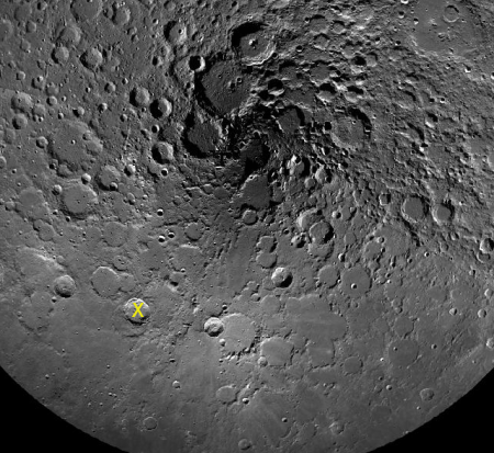
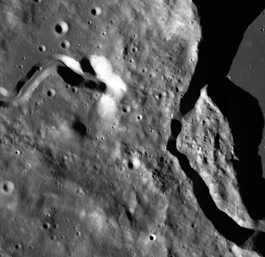
Below is a image of the entire crater, with the area of the image above indicated by a white box. It shows clearly how this crater splashed into the basalt lava plain of Mare Imbrium.
» Read more

LRO pinpoints Chang’e-4 landing site

LRO pinpointing Chang'e-4's location on Moon

By referencing the footage released by China of Chang’e-4’s descent onto the Moon, the Lunar Reconnaissance Orbiter (LRO) team has been able to pinpoint exactly where the lander touched down. The image on the right has been reduced slightly. Click on it to see it in full resolution.

The largest nearby crater to the lander is estimated to be about 80 feet across.

Because the images were in December 2018 before the lander’s arrival, they do not show it. However, the LRO team now knows exactly where to look when they take new pictures in the next few weeks. Moreover, this will allow them to monitor Yutu-2’s travels as it roves the surface over the coming months.

Using LRO to find Chang’e-4

LRO image of Chang'e-4 landing area

The Lunar Reconnaissance Orbiter (LRO) science team has released a high resolution image from 2010 pinpointing the area on the floor of Von Kármán crater where Chang’e-4 landed. On the right is a reduced and partly annotated version.

They have not actually found the lander/rover, since this image was taken long ago before Chang’e-4 arrived. However, this image, combined with the Chang’e-4 landing approach image, tells us where the lander approximately landed. It also pinpoints where to look for it when LRO is next able to image this region, around the end of January.

By then, Yutu-2 will hopefully have traveled some distance from Chang’e-4, and LRO will be able to spot both on the surface.

A young lunar impact crater

Lunar crater

Cool image time! The science team from Lunar Reconnaissance Orbiter (LRO) today released a new image, taken on November 3, 2018, of a relatively young small crater not easily seen from Earth.

The unnamed crater, just 1.8 kilometers across, is too small to see from Earth with unaided eyes. It is in the Moon’s wild west, just past Oceanus Procellarum and close to the line dividing the nearside from the farside, so it would be hard to glimpse in any case. If you stood on the crater rim, you would see the Earth forever slowly bobbing up, down, and sideways close to the eastern horizon.

The image above is a cropped and reduced-in-resolution section of the released image. If you click on it you can see this section at full resolution.

What I find fascinating about this crater are the black streaks that appear to only run down the outside slopes of the eastern rim, but nowhere else. At first glance it looks like prevailing winds, blowing from the west, caused this, but of course that’s wrong because the Moon has no atmosphere. The website explains:
» Read more

The fractured floor of Komarov Crater

Fractured floor of Komarov Crater

Cool image time! The Lunar Reconnaissance Orbiter (LRO) oblique image on the right, reduced significantly from the original to post here, shows the deeply fractured floor of Komarov Crater on the Moon’s far side. As noted at the image link,

The spectacular fractures that cut across the floor of Komarov crater [about 85 kilometers or 50 miles diameter] were formed when magma rose from the mantle, uplifting and fracturing the crater in the process. In this case the magma did not erupt to the surface, thus the fractures remain visible.

The Komarov fractures are quite large, the major left-to-right fracture that cuts across the center of the scene is over 500 meters deep [1,600 feet] and 2500 meters wide [1.5 miles]. When did they form? The large number of craters superimposed on the floor and fractures testifies to their ancient ages. Likely they are of the same vintage (>2.6 billion years) as the Mare Moscoviense lava plains just to the north

An overview of Komarov Crater as well as other LRO images of it can be found here.

The question that comes to my mind is the relative rarity of craters with such large fractures on their floors. I have noted this for Mars as well. It is expected that there is melt on the floor of all large impact craters. Why do a few produce such pronounced fractures, while most do not? This website posits one explanation, but its complexity leaves me unsatisfied. It also doesn’t explain why it happens only rarely.

The central peaks of Copernicus crater

Central peaks of Copernicus Crater

Cool image time! Lunar Reconnaissance Orbiter science team has released a new image of the central peaks of Copernicus Crater, shown on the right cropped and reduced in resolution.

Copernicus (9.62°N, 339.92°E), which is easily seen with a moderately powerful backyard telescope, is one of the best-known craters on the Moon. Despite its age (around 860 million years), it is well preserved with over 4000 meters of relief from floor to rim, and the tallest of its central peaks rises approximately 1300 meters above the crater floor. This image, centered on the central peaks, was captured just after dawn (86° incidence angle) as the Lunar Reconnaissance Orbiter slewed west to a 67°angle.

The image is similar to one taken back in 2012, but has a higher resolution because it was shot from 50 miles elevation instead of 75.

This crater was also the subject of one of the first breath-taking images ever taken of the Moon from lunar orbit, by Lunar Orbiter in November 1966.

The wider view taken by LRO gives some context for the image above. The peaks shown in closeup here are part of the lower right grouping. If you go to the first link above you can zoom in and explore all parts of the full image, and see some quite amazing details, including the large boulders scatter throughout the hollows between the peaks.

Copernicus Crater

Mountains on the Moon

Mountains on the Moon

Cool image time! The image on the right, reduced slightly to post here, shows several high mountains on the far side of the Moon. If you click on the image you can see it at full resolution.

The summit of the unnamed peak in the foreground (50.2° S, 236.6° E) has an elevation of 6710 meters, about 7000 meters (about 23,000 feet) of relief relative to the low point at the bottom of the image. The two peaks on the horizon, 200 kilometers in the distance (about 125 miles), have summit elevations of 4320 meters (14,200 feet) and 4680 meters (15,350), respectively and both rise more than 6000 meters (almost 20,000 feet) above their surroundings.

In the Lunar Reconnaissance Orbiter (LRO) science team release in June, they noted that the high peak here is actually taller than Denali (Mount McKinley), the highest peak within the U.S. And it has no name. They also note that the peak is likely 4 billion years old, and has experienced extensive erosion in that time, meaning that it is also likely shorter than it once was.

I don’t have anything to add, other than this would be an amazing place to put up a resort, with trails taking you to the top of the mountains. In the lighter gravity, the hike would actually be somewhat easy, even wearing a spacesuit. And you wouldn’t have to worry about a thinning atmosphere as you climbed higher, as you do on Earth. You’d be carrying it with you.

Oblique view of lunar crater

Wallach Crater

Cool image time! The Lunar Reconnaissance Orbiter (LRO) science team this week released an image showing Wallach Crater as seen from the side. The image on the right is a section of that image and has been reduced to show here. The full image of 3.5-mile-wide crater and its surrounding terrain can be explored at the link. From the link:

Wallach crater (4.89°N, 32.27°E) formed within a thin layer of black basaltic lava flows that overlie much brighter anorthositic material. Think of a white cake with chocolate icing. When the asteroid (or comet) impacted this “iced cake”, ejecta from deeper portions (white cake, or rather brighter anorthosite) was thrown out onto the icing (darker basalt) resulting in intermediate tones where the two materials mixed.

The dark streaks seen inside the crater are blocks of the icing (basalt) breaking off and creeping down slope. The fact that the deepest material lands on top of the shallowest material (known as inverted stratigraphy) was first described by Gene Shoemaker from his pioneering observations at Meteor Crater, Arizona. This effect simplifies sampling the local geology in three dimensions. As an astronaut traverses towards the rim of a crater, the rocks underfoot come from deeper and deeper within the crater. The rocks at the rim are from the deepest portions of the crater!

It is especially interesting to use the viewer at the link to see the surrounding terrain, which includes two other craters that are far less distinct.

Aristarchus Crater on the Moon

Aristarchus Crater

Cool image time! The image on the right, reduced in resolution to post here, shows Aristarchus Crater, one of the more geological intriguing locations on the Moon. This oblique image was taken by Lunar Reconnaissance Orbiter (LRO), still operating in lunar orbit. If you click on the image you can see the full resolution image.

Aristarchus crater is 40 kilometers (25 miles) in diameter and 2700 meters (1.7 miles) deep, with a central peak that rises 300 meters (almost a thousand feet) above the crater floor. When LRO pointed back towards the Sun, LROC was able to capture this magnificent view highlighting subtle differences in albedo (brightness). Some of the albedo contrast is due to maturity (young material is generally brighter than older material) and some reveal true differences in rock type. The central peak shows the complexity of what lies beneath the now hardened impact melt sea that filled the bottom of the crater.

The best part however is the close-up they provided of the crater’s central peaks, posted below.
» Read more

A lava tube entrance near the Moon’s north pole?

Philolaus Crater near lunar north pole

In reviewing Lunar Reconnaissance Orbiter data scientists think they have discovered several skylight entrances into a lava tube that is located near the Moon’s north pole.

The new pits were identified on the northeastern floor of Philolaus Crater, a large, 43 mile (70 km)-diameter impact crater located at 72.1oN, 32.4oW, about 340 miles (550 km) from the North Pole of the Moon, on the lunar near side. The pits appear as small rimless depressions, typically 50 to 100 feet across (15 to 30 meters), with completely shadowed interiors. The pits are located along sections of winding channels, known on the Moon as “sinuous rilles,” that crisscross the floor of Philolaus Crater. Lunar sinuous rilles are generally thought to be collapsed, or partially collapsed, lava tubes, underground tunnels that were once streams of flowing lava.

“The highest resolution images available for Philolaus Crater do not allow the pits to be identified as lava tube skylights with 100 percent certainty, but we are looking at good candidates considering simultaneously their size, shape, lighting conditions and geologic setting” says Pascal Lee, planetary scientist at the SETI Institute and the Mars Institute who made the new finding at NASA’s Ames Research Center in Silicon Valley.

…Prior to this discovery, over 200 pits had been found on the Moon by other researchers, with many identified as likely skylights leading to underground lava tubes associated with similar sinuous rilles. However, today’s announcement represents the first published report of possible lava tube skylights in the Moon’s polar regions.

The floor of the crater as a lot of rilles, and a close look at that crater floor reveals to me a lot of possible sky light entrances, more than indicated by the images at the llink. (Go here, click on projections and pick “Orthographic (North Pole).” Then zoom in on the crater indicated by the yellow X in my image on the right above.)

The key here is that caves or lava tubes provide a good place to cheaply and quickly establish a lunar colony. While it is suspected that water might survive in permanently shadowed regions near the poles, up until now no one had found any good underground locations there. If this suspected skylight entrances prove true, this crater then becomes prime real estate on the Moon.

Scientists finally image SMART-1 lunar impact site

SMART-1 impact site

Eleven years after the European SMART-1 probe was sent crashing onto the Moon’s surface, scientists have finally identified in a Lunar Reconnaissance Orbiter image that crash site.

The image is shown on the right, reduced and cropped to post here.

The images show a linear gouge in the surface, about four metres wide and 20 metres long, cutting across a small pre-existing crater. At the far end, a faint fan of ejecta sprays out to the south. Foing said: “The high resolution LRO images show white ejecta, about seven metres across, from the first contact. A north-south channel has then been carved out by the SMART-1 spacecraft body, before its bouncing ricochet. We can make out three faint but distinct ejecta streams from the impact, about 40 metres long and separated by 20-degree angles.”

Stooke said: “Orbit tracking and the impact flash gave a good estimate of the impact location, and very close to that point was a very unusual small feature. It now seems that impacts of orbiting spacecraft, seen here from SMART-1, and also in the cases from GRAIL and LADEE, will form elongated craters, most of whose rather faint ejecta extends downrange”.

Frost on the Moon?

A new analysis of Lunar Reconnaissance Orbiter data suggests that the coldest spots at the Moon’s south pole are also its brightest, even though they are generally in shadow, suggesting that the surface there might have a thin layer of water frost.

These are also the areas where hydrogen has been detected, which strengthens the theory that this is water.

However, the result is not a positive one for future colonists as it suggests that the amount of water on the Moon is far less than hoped. First, there is this:

The icy deposits appear to be patchy and thin, and it’s possible that they are mixed in with the surface layer of soil, dust and small rocks called the regolith. The researchers say they are not seeing expanses of ice similar to a frozen pond or skating rink. Instead, they are seeing signs of surface frost.

Second, they have not detected this same pattern at the north pole, which strongly suggests that the permanently shadowed areas there do not even have frost.

Overall, this result suggests that the Moon might have water on its surface, but not in great quantities.

LRO hit by meteoriod in 2014

LRO as it was hit by a meteor

While taking an image in October 2014, Lunar Reconnaissance Orbiter had apparently been hit by some small object, causing it to vibrate and create the zig-zag distortions seen on the image, a cropped section of which is shown on the right.

Clearly there was a brief violent movement of the left NAC [Narrow Angle Camera]. The only logical explanation is that the NAC was hit by a meteoroid! How big was the meteoroid, and where did it hit? The physical properties and vibration modes of the NAC are very well known – during development a detailed computer model was made to ensure the NAC would not fail during the vibrations caused by the launch, which are severe. The computer model was tested before launch by attaching the NAC to a vibration table that simulates launch. The model was solid, both NACs survived the test, and launch.

Most of each NAC is sequestered inside the spacecraft structure, so only the leading edge of the baffle and the radiator are exposed to space, and thus are potential targets for impactors. From the detailed computer model, the LROC team ran simulations to see if we could reproduce the distortions seen the image. Assuming an impact velocity of 7 kilometers per second and a density 2.7 g/cm3, an impacting particle would have been 0.8 mm in diameter (~half the size of a pinhead). If the velocity was faster, then the particle would have been smaller, and if slower then larger.

For comparison, the muzzle velocity of a bullet fired from a rifle is typically 0.5 to 1.0 kilometers per second. So the meteoroid was traveling much faster than a speeding bullet. In this case LROC did not dodge a speeding bullet, but rather survived a speeding bullet!

The image is fascinating because you can see the vibrations slowly disappear as the zig-zags shrink and fade.

LRO finds lunar impact site for Apollo rocket stage

Lunar Reconnaissance Orbiter has located the impact site for the Apollo 16 rocket booster that, like four other boosters, had been deliberately crashed on the surface so the Apollo seismometers could use the vibrations to study the Moon’s interior.

The other impact sites had been found already, but Apollo 16 was harder to pin down because contact with the booster had ended prematurely so its location was less well known.

200 new lunar impact craters discovered

In a paper [pdf] presented this week at a lunar science conference, scientists announced the identification of more than 200 new impact craters on the Moon from Lunar Reconnaissance Orbiter (LRO).

As of 1 May 2015, we have scanned and classified changes in 14,182 NAC temporal pairs using our automated change detection tool leading to the discovery over 200 impact craters ranging in size from 1.5 to 43 m. In addition, we also identified thousands of other surface changes, including about 44,000 low reflectance splotches, 3,500 high reflectance splotches, 850 mixed reflectance splotches, [and] 1 Chinese lander/rover.

They think the splotches are created from impacts too small to see with LRO.

Hat tip James Fincannon.

LADEE impact site located

Lunar Reconnaissance Orbiter has spotted the impact crater formed when engineers sent the probe LADEE crashing into the lunar surface in April 2014.

Compared with asteroid and meteoroid impacts on the moon, LADEE was actually traveling pretty slow, ‘only’ 3,800 miles per hour (1,700 meters per second). That combined with the relatively low mass and density of the spacecraft, a fairly neat crater of only 10 feet (3 meters) across was created. The crater barely registered in LROC’s image resolution, making it a very difficult task to identify the fresh man-made divot.

Recent volcanism on the Moon

New data from Lunar Reconnaissance Orbiter suggests that lunar volcanism petered out slowly and occurred more recently that previously believed.

NASA’s Lunar Reconnaissance Orbiter (LRO) has provided researchers strong evidence the moon’s volcanic activity slowed gradually instead of stopping abruptly a billion years ago. Scores of distinctive rock deposits observed by LRO are estimated to be less than 100 million years old. This time period corresponds to Earth’s Cretaceous period, the heyday of dinosaurs. Some areas may be less than 50 million years old. Details of the study are published online in Sunday’s edition of Nature Geoscience. “This finding is the kind of science that is literally going to make geologists rewrite the textbooks about the moon,” said John Keller, LRO project scientist at NASA’s Goddard Space Flight Center in Greenbelt, Maryland.

In a way, this new conclusion is an example of science discovering the obvious. It seems to me quite unlikely that volcanic activity on the Moon would have “stopped abruptly” under any conditions. That’s not how these things work.

Budget issues continue to threaten a number of successfully functioning science spacecraft, including Opportunity on Mars and Lunar Reconnaissance Orbiter circling the Moon.

Penny wise, pound foolish: Budget issues continue to threaten a number of successfully functioning science spacecraft, including Opportunity on Mars and Lunar Reconnaissance Orbiter circling the Moon.

Don’t be surprised if NASA announces soon that they are shutting down these spacecraft so they can save some money. Or as the article notes, “Money not spent on these extended missions will probably slide into [the Science Mission Directorate’s] Black Hole of Funding (the James Webb Space Telescope) or be dissipated on new paperwork, committee meetings and concept studies.”

New geological research suggests that the hydrogen levels that have detected on the moon — which are used to predict the presence of water — might be a false positive and not exist at the levels predicted.

The uncertainty of science: New geological research suggests that the hydrogen levels that have been detected on the moon — which are used to predict the presence of water — might be a false positive and not exist at the levels predicted.

Instead, what scientists thought was hydrogen in water molecules might be calcium as part of a mineral called apatite. If so, this would mean that the Moon has a lot less water than hoped. This data might also explain the lack of water seen in the Apollo samples as compared to what is suggested should be there from more recent orbital data. This also might explain the conflicting results from instruments on Lunar Reconnaissance Orbiter.

Some spectacular oblique images from Lunar Reconnaissance Orbiter have been released.

Some spectacular oblique images from Lunar Reconnaissance Orbiter (LRO) have been released.

The top three images are all oblique. Make sure you click through to the full caption of each image to get more information.

The Lunar Alps image is especially interesting to those who have ever explored the Moon with a telescope from Earth. The rill shown is well known to amateurs, as are the Montes Alpes, or Alps Mountains, adjacent to it. From Earth that rill definitely looks like a meandering river canyon. This LRO image resolves it into a canyon made up of a series of crater-like depressions, a geological feature quite different from the river canyons of Earth.

Data from an experiment on Lunar Reconnaissance Orbiter has confirmed that light plastics can provide sufficient protection for humans against radiation.

Data from an experiment on Lunar Reconnaissance Orbiter has confirmed that light plastics can provide sufficient protection for humans against radiation.

This is very good news indeed. Combined with the data from Curiosity, which indicated that the radiation levels in interplanetary space were less intense that expected, it appears that radiation will not be a serious obstacle to interplanetary travel.

Now we just have to get the bone loss and vision problems solved.

The impact of a 100 pound meteorite on the Moon in March produced the brightest flash ever recorded.

The impact of a 100 pound meteorite on the Moon in March produced the brightest flash ever recorded.

Anyone looking at the Moon at the moment of impact could have seen the explosion–no telescope required. For about one second, the impact site was glowing like a 4th magnitude star.

Ron Suggs, an analyst at the Marshall Space Flight Center, was the first to notice the impact in a digital video recorded by one of the monitoring program’s 14-inch telescopes. “It jumped right out at me, it was so bright,” he recalls.

The 40 kg meteoroid measuring 0.3 to 0.4 meters wide hit the Moon traveling 56,000 mph. The resulting explosion1 packed as much punch as 5 tons of TNT.

It will be really interesting to see the Lunar Reconnaissance Orbiter images of the impact site, which can’t be taken until the spacecraft passes over the site and can photograph it.

Water Ice in Shackleton Crater?

Ice in Shackleton?

New results from the radar instrument on Lunar Reconnaissance Orbiter (LRO) has found evidence of water-ice on the slopes of Shackleton Crater, located at the Moon’s south pole. The paper, published on Saturday in Geophysical Research Letters – Planets, suggested that about 5 to 10 percent of the weight of the material on the slopes of the crater is comprised of water ice, to depths of 6 to 10 feet.

The box on the upper left in the image to the right shows the data from a radar sweep of the crater taken on April 18, 2010, and compares that to five computer models. As you can see, the data here most closely matches the 5% ice model. Two other sweeps showed similar results.

The water-ice, if there, is not in slabs of ice, as sometimes portrayed in the press, but would be mixed into the Moon’s regolith, or “topsoil”, and would have to be processed out like ore to be useful. Or to quote the paper’s conclusion:

The fundamental conclusions made with high resolution, ground based radar of Shackleton remain unaltered — that no large-scale, meters thick ice deposits are evident within the crater. Rather, Mini-RF data are consistent with roughness effects or with a small percentage of water-ice deposits admixed into the uppermost 1-2 meters of silicate regolith within Shackleton, possibly accounting for the observations made by the Clementine bistatic experiment.

Several points:
» Read more

Water on the Moon? The battle continues

LEND data of lunar south pole

A little over a month ago I reported here on Behind the Black some recent results from the LEND instrument on Lunar Reconnaissance Orbiter (LRO) that had found significantly less water in the permanently shadowed craters at the lunar poles than previously thought. To quote again from that paper’s abstract, which I will henceforth refer to as Sanin, et al:

This means that all [permanently shadowed regions], except those in Shoemaker, Cabeus and Rozhdestvensky U craters, do not contain any significant amount of hydrogen in comparison with sunlit areas around them at the same latitude.

And from the paper’s conclusion:

[E]ven now the data is enough for definite conclusion that [permanently shadowed regions] at both poles are not reservoirs of large deposits of water ice.

Paul Spudis of the Lunar and Planetary Institute in Houston, Texas and one of the world’s top lunar scientists then commented as follows:

You neglect to mention yet another possibility — that this paper and its conclusions are seriously flawed in almost every respect. The veracity of the LRO collimated neutron data [produced by the LEND instrument] have been questioned on serious scientific grounds. Other data sets (spectral, radar) suggest significant amounts of water at both poles, billions of metric tons in total.

Spudis also discussed this scientific dispute at length on his own blog.

When I read Dr. Spudis’s comment I immediately emailed William Boynton of the Lunar and Planetary Laboratory at the University of Arizona, one of the authors of the Sanin et al paper, to get his reaction. Today he sent me the following detailed explanation, describing the basis of the controversy and why he believes the LEND data is valid.
» Read more

Lunar Reconnaissance Orbiter has published another spectacular oblique image of Tycho crater.

Tycho Oblique image thumbnail

Lunar Reconnaissance Orbiter has published another spectacular oblique image of Tycho crater.

If you look closely at the slope of the mountain, you can see an avalanche trail at its center and the debris piled up at the mountain’s base.

See the first oblique image, released in June 2011, here. The two images look at the crater from opposite directions.

1 2 3 4