New study says recurring dark streaks on Mars are from flowing sand, not water

The uncertainty of science: A new study has concluded that the recurring dark streaks on Martian slopes are caused not from flowing seeps of water but from small sand avalanches.

Continuing examination of these still-perplexing seasonal dark streaks with a powerful camera on NASA’s Mars Reconnaissance Orbiter (MRO) shows they exist only on slopes steep enough for dry grains to descend the way they do on faces of active dunes.

The findings published today in Nature Geoscience argue against the presence of enough liquid water for microbial life to thrive at these sites. However, exactly how these numerous flows begin and gradually grow has not yet been explained. Authors of the report propose possibilities that include involvement of small amounts of water, indicated by detection of hydrated salts observed at some of the flow sites.

The results do not exclude the possibility that water plays a part, but do suggest it plays a much smaller part, or none at all.

7 comments

Mars rover update: November 16, 2017

Summary: Curiosity does drill tests, crosses Vera Rubin Ridge. Opportunity finds evidence of either ice or wind scouring on rocks in Perseverance Valley.

Curiosity

For the overall context of Curiosity’s travels, see Pinpointing Curiosityโ€™s location in Gale Crater.

Curiosity looks up Vera Rubin Ridge, Sol 1850

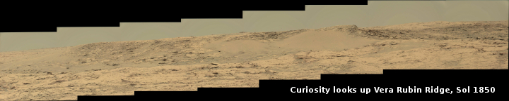
Since my last update on September 6, Curiosity has continued its travels up and across Vera Rubin Ridge, a geological bedding plain dubbed the Hematite Unit. The panorama above, created by reader Phil Veerkamp, shows the view looking up the ridge slope. If you click on it you can see the full resolution image, with lots of interesting geological details.

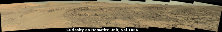
The panorama below, also created by Veerkamp, shows the view on Sol 1866, two weeks later, as the slope begins to flatten out and the distant foothills of Mount Sharp become visible. (If you click on the image you can see a very slightly reduced version of the full resolution panorama.) This image also shows the next change in geology. From orbit the Hematite Unit darkens suddenly at its higher altitudes, and Curiosity at this point was approaching that transition. The rover is now, on Sol 1876, sitting on that boundary, where they will spend a few days making observations before moving on.

Curiosity on the Hematite Unit, Sol 1866

null

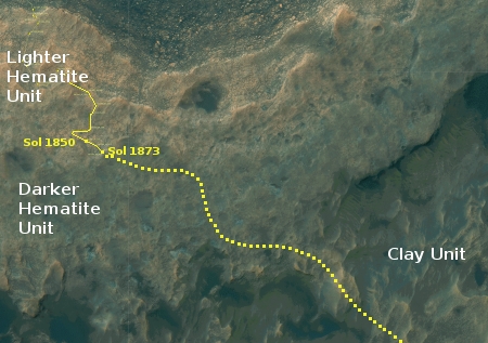
The image on the right shows Curiosity’s approximate position, about halfway across the Hematite Unit and with the rover’s approximate future route indicated, as shown in this October 3, 2016 press release.

In the two months since my last rover update the Curiosity engineering team has spent a lot of time imaging and studying the Hematite Unit. They have also spent a considerable amount of time doing new tests on the rover’s drill in an effort to get around its stuck feed mechanism in order to drill again. Only yesterday they took another series of close-up images of the drill in this continuing effort.

As indicated by the October 3 2016 press release, the rover still has a good way to go before it begins entering the distant canyons and large foothills. While they should leave the Hematite Unit and enter the Clay Unit beyond in only a few more months, I expect it will be at least a year before they pass through the Clay Unit and reach the much more spectacular Sulfate Unit, where the rover will explore at least one deep canyon as well as a recurring dark feature on a slope that scientists think might be a water seep.

Opportunity

For the context of Opportunity’s recent travels along the rim of Endeavour Crater, see my May 15, 2017 rover update.
» Read more

0 comments

NASA completes first high altitude supersonic test of Mars 2020 rover parachute

NASA successfully completed its first high altitude supersonic test of the parachute that the Mars 2020 rover will use as part of its landing operation.

The rocket carried the payload as high as about 32 miles (51 kilometers). Forty-two seconds later, at an altitude of 26 miles (42 kilometers) and a velocity of 1.8 times the speed of sound, the test conditions were met and the Mars parachute successfully deployed. Thirty-five minutes after launch, ASPIRE splashed down in the Atlantic Ocean about 34 miles (54 kilometers) southeast of Wallops Island. “Everything went according to plan or better than planned,” said Clark. “We not only proved that we could get our payload to the correct altitude and velocity conditions to best mimic a parachute deployment in the Martian atmosphere, but as an added bonus, we got to see our parachute in action as well.”

The parachute tested during this first flight was almost an exact copy of the parachute used to land NASA’s Mars Science Laboratory successfully on the Red Planet in 2012. Future tests will evaluate the performance of a strengthened parachute that could also be used in future Mars missions. The Mars 2020 team will use data from these tests to finalize the design for its mission.

There is a nice video of this test flight at the link.

At first glance one wonders why they need to do these tests, since the parachute system is going to be almost identical to the one used by Curiosity in 2012, and that worked perfectly. However, they really aren’t testing the parachute but the system to fly and test future parachutes at the high altitudes that mimic Martian conditions. With this test technology working and available, it will make it possible to test all kinds of parachute designs for use on Mars, even Rogollo hang-glider chutes.

14 comments

Exploring one of Mars’ giant volcanoes

Master index

For the past two weeks JPL’s image site has been releasing a string of images taken by Mars Odyssey of the smallest of Mars’ four giant volcanoes.

Pavonis Mons is one of the three aligned Tharsis Volcanoes. The four Tharsis volcanoes are Ascreaus Mons, Pavonis Mons, Arsia Mons, and Olympus Mars. All four are shield type volcanoes. Shield volcanoes are formed by lava flows originating near or at the summit, building up layers upon layers of lava. The Hawaiian islands on Earth are shield volcanoes. The three aligned volcanoes are located along a topographic rise in the Tharsis region. Along this trend there are increased tectonic features and additional lava flows. Pavonis Mons is the smallest of the four volcanoes, rising 14km above the mean Mars surface level with a width of 375km. It has a complex summit caldera, with the smallest caldera deeper than the larger caldera. Like most shield volcanoes the surface has a low profile. In the case of Pavonis Mons the average slope is only 4 degrees.

The image on the right is the context image, annotated by me to show where all these images were taken. The images can accessed individually below.

Each of these images has some interesting geological features, such as collapses, lava tubes, faults, and flow features. Meanwhile, the central calderas are remarkable smooth, with only a few craters indicating their relatively young age.

The most fascinating geological fact gleaned from these images is that they reveal a larger geological trend that runs through all of the three aligned giant volcanoes to the east of Olympus Mons.

The linear and sinuous features mark the locations of lava tubes and graben that occur on both sides of the volcano along a regional trend that passes thru Pavonis Mons, Ascreaus Mons (to the north), and Arsia Mons (to the south).

This trend probably also indicates the fundamental geology that caused all three volcanoes to align as they have.

Arsia Mons is of particular interest in that water clouds form periodically above its western slope, where there is also evidence of past glaciation. Scientists strongly suspect that there is a lot of water ice trapped underground here, possibly inside the many lava tubes that meander down its slopes. These facts also suggest that this might be one of the first places humans go to live, when they finally go to live on Mars.

27 comments

MIT redwood forest design wins 2017 Mars City Design competition

A MIT design for an early Martian colony based on underground habitats topped by geodesic domes filled with redwood forests has won the 2017 Mars City Design competition.

At first glance, the MIT habitats don’t look very tree-like. They look more like giant glass balls sitting on the Martian plains, each housing 50 people. But, like real trees, much of the habitat is below the surface in the form of intricate tunnels that connect the spheres and provide protection from cold, radiation, micrometeorites, and other surface hazards. “On Mars, our city will physically and functionally mimic a forest, using local Martian resources such as ice and water, regolith or soil, and sun to support life,” says Sumini. “Designing a forest also symbolizes the potential for outward growth as nature spreads across the Martian landscape. Each tree habitat incorporates a branching structural system and an inflated membrane enclosure, anchored by tunneling roots. The design of a habitat can be generated using a computational form-finding and structural optimization workflow developed by the team. The design workflow is parametric, which means that each habitat is unique and contributes to a diverse forest of urban spaces.”

The habitats rely heavily on water, but not just for drinking, agriculture, or public fountains. It’s a key ingredient in making the domes habitable. “Every tree habitat in Redwood Forest will collect energy from the sun and use it to process and transport the water throughout the tree, and every tree is designed as a water-rich environment,” says Department of Aeronautics and Astronautics doctoral student George Lordos. “Water fills the soft cells inside the dome providing protection from radiation, helps manage heat loads, and supplies hydroponic farms for growing fish and greens. Solar panels produce energy to split the stored water for the production of rocket fuel, oxygen, and for charging hydrogen fuel cells, which are necessary to power long-range vehicles as well as provide backup energy storage in case of dust storms.”

This is a very nice concept, and an excellent approach. While they appear to assume the underground habitats will be artificially dug, there is no reason the tree domes can’t be placed over a Martian pit entrance to a cave.

26 comments

Squiggles on Mars

Squiggles on Mars

Cool image time! The image on the right, reduced and cropped to post here, shows a sand dune slope with numerous squiggly troughs that end either in a small pit or slowly fade away. At first glance one things the troughs were caused by a boulder rolling downhill, but there are no boulders at the base of the slope, and a rolling boulder wouldn’t create so many similar squiggles like this.

The explanation is that the boulders are made of carbon dioxide ice.

Just like on Earth, high-latitude regions on Mars are covered with frost in the winter. However, the winter frost on Mars is made of carbon dioxide ice (dry ice) instead of water ice. We believe linear gullies are the result of this dry ice breaking apart into blocks, which then slide or roll down warmer sandy slopes, sublimating and carving as they go.

The linear gullies exhibit exceptional sinuosity (the squiggle pattern) and we believe this to be the result of repeated movement of dry ice blocks in the same path, possibly in combination with different hardness or flow resistance of the sand within the dune slopes.

For a really entertaining explanation of this process, take a look at the embedded video below the fold.
» Read more

0 comments

Engineers develop new technique to resume drill use on Curiosity

Engineers have successfully tested a new drill procedure on a duplicate rover on Earth that bypasses the problem in Curiosity’s drill.

The problem with the drill has been its feed mechanism, which pushes the drill bit downward as it drills its hole. The tests with the duplicate rover on Earth have instead had the drill bit fully extended and used the robot arm itself to push downward. It worked, but the problem on Mars is holding the drill bit perfectly straight and not slipping sideways. They are now doing a test with Curiosity to address this.

Curiosity touched its drill to the ground Oct. 17 for the first time in 10 months. It pressed the drill bit downward, and then applied smaller sideways forces while taking measurements with a force sensor. “This is the first time we’ve ever placed the drill bit directly on a Martian rock without stabilizers,” said JPL’s Douglas Klein, chief engineer for the mission’s return-to-drilling development. “The test is to gain better understanding of how the force/torque sensor on the arm provides information about side forces.”

This sensor gives the arm a sense of touch about how hard it is pressing down or sideways. Avoiding too much side force in drilling into a rock and extracting the bit from the rock is crucial to avoid having the bit get stuck in the rock.

Stay tuned for a Mars rover update, coming shortly!

0 comments

Producing oxygen and fuel from Martian CO2

New research suggests that the conditions on Mars are ideal for using its carbon dioxide to produce both oxygen and fuel for future manned missions.

Mars has excellent conditions for In-Situ Resource Utilisation (ISRU) by plasma. As well as its CO2 atmosphere, the cold surrounding atmosphere (on average about 210 Kelvin) may induce a stronger vibrational effect than that achievable on Earth. The low atmospheric temperature also works to slow the reaction, giving additional time for the separation of molecules.

Dr Guerra said: โ€œThe low temperature plasma decomposition method offers a twofold solution for a manned mission to Mars. Not only would it provide a stable, reliable supply of oxygen, but as source of fuel as well, as carbon monoxide has been proposed as to be used as a propellant mixture in rocket vehicles.

While achieving this kind of in-situ resource use is not trivial, it is essential if humans are going to settle colonies on Mars. This research seems to be a good start.

24 comments

Europe’s Trace Gas Orbiter detects clouds over Martian volcano

Europe’s Trace Gas Orbiter (TGO) has detected clouds over the western slopes of the giant Martian volcano Arsia Mons.

This is not a new discovery, merely a confirmation of many past observations, all of which suggest that water-ice glaciers once flowed down those western slopes, and that some of that ice remains trapped in underground caves and lava tubes there. Undeniably this region appears at present to be the most valuable real estate on Mars. It has caves where the first colonies can be more easily built. Those caves likely have water in them. And the location is near the equator, which is easier to reach and also makes the environment somewhat less hostile.

TGO is presently slowly aerobraking itself down to its planned science orbit, which it is expected to reach in 2018.

7 comments

The mysterious dark splotches of Mars

The dark splotches of Mars

Cool image time! The image on the right, cropped and reduced in resolution to post here, shows one particular dark splotch in a region with several similar dark areas.

Geologists arenโ€™t quite sure what to make of the dark splotch in the middle of this image, one of several similar dark splotches that extend east and west for over 100 kilometers. From measurements made in infrared, this and other dark splotches have what we call โ€œhigh thermal inertia,โ€ meaning that it heats up and cools down slowly. Scientists use thermal inertia to assess how rocky, sandy, or dusty a place is. A higher thermal inertia than the surrounding area means itโ€™s less dusty.

The image below the fold shows at full resolution the area indicated by the white box. It provides me no clue as to the cause for the darker color. I think we can speculate all we want, but the truth is that we simply don’t have enough information. We need a closer look, including boots on the ground, to figure this out.
» Read more

4 comments

Mars Odyssey makes its first observations of Phobos

Sixteen years after entering Mars orbit Mars Odyssey finally made its first observations of the Martian moon Phobos last week.

Since Odyssey began orbiting the Red Planet in 2001, THEMIS has provided compositional and thermal-properties information from all over Mars, but never before imaged either Martian moon. The Sept. 29 observation was completed to validate that the spacecraft could safely do so, as the start of a possible series of observations of Phobos and Deimos in coming months.

In normal operating mode, Odyssey keeps the THEMIS camera pointed straight down as the spacecraft orbits Mars. In 2014, the spacecraft team at Lockheed Martin Space Systems, Denver; and NASA’s Jet Propulsion Laboratory, Pasadena, California; and the THEMIS team at Arizona State University, Tempe, developed procedures to rotate the spacecraft for upward-looking imaging of a comet passing near Mars. The teams have adapted those procedures for imaging the Martian moons.

The data from this particular observation is less significant than the fact that the spacecraft can now do it. Expect some new results about the Martian moons in the coming months.

0 comments

Solar storm activates global aurora on Mars

The strong solar flare that occurred earlier this month was strong enough to activate a global aurora on Mars.

The solar event on Sept. 11, 2017 sparked a global aurora at Mars more than 25 times brighter than any previously seen by the MAVEN orbiter, which has been studying the Martian atmosphere’s interaction with the solar wind since 2014. It produced radiation levels on the surface more than double any previously measured by the Curiosity rover’s Radiation Assessment Detector, or RAD, since that mission’s landing in 2012. The high readings lasted more than two days.

Strangely, it occurred in conjunction with a spate of solar activity during what is usually a quiet period in the Sun’s 11-year sunspot and storm-activity cycle. This event was big enough to be detected at Earth too, even though Earth was on the opposite side of the Sun from Mars.

1 comment
1 158 159 160 161 162 212