Curiosity attempts to drill with improvised technique

The Curiosity engineering team has made the first attempt to drill in more than a year, using an improvised technique that has the rover arm push the bit into the ground rather than its presently non-function feed mechanism.

This early test produced a hole about a half-inch (1-centimeter) deep at a target called Lake Orcadie — not enough for a full scientific sample, but enough to validate that the new method works mechanically. This was just the first in what will be a series of tests to determine how well the new drill method can collect samples. If this drill had achieved sufficient depth to collect a sample, the team would have begun testing a new sample delivery process, ultimately delivering to instruments inside the rover.

According to the mission update page, for some reason the drill was unable to penetrate the ground very deeply.

They plan to do more tests, with the goal of eventually getting a hole deep enough to provide good samples.

0 comments

Microbes found that survive in the driest desert on Earth

Scientists have found that certain microbes can remain dormant for years in the Atacama Desert and then come to life during the rare times water is available.

The Atacama Desert stretches inland 1000 kilometers from the Pacific coast of Chile, and rainfall can be as low as 8 millimeters per year. There’s so little precipitation that there’s very little weathering, so over time the surface has built up a crusty layer of salts, further discouraging life there. “You can drive for 100 kilometers and not see anything like a blade of grass,” Neilson says. Although she and others have found some bacteria there, many biologists have argued that those microbes are not full-time residents, but were blown in, where they die a slow death.

But that didn’t deter Dirk Schulze-Makuch, an astrobiologist at the Technical University of Berlin. “I like to go to places where people say nothing is alive,” he says. “We decided to take a shotgun approach and throw all the new [analytical] approaches at everything—fungi, bacteria, viruses”—that might be there. He and his team collected samples from eight places in the Atacama—from the coast eastward to the driest places—over 3 years. They first gathered material a month after a record-setting rain in 2015, and then followed up with yearly collections in some of the same places in 2016 and 2017. They sequenced all the copies of a gene known to distinguish microbial species to determine what was in those samples and even recovered some full genomes. The researchers also did a test to determine the proportion of DNA that came from intact, living cells. Finally, they assessed the amount of cellular activity; of adenosine triphosphate (ATP), a molecule the fuels this activity; and of byproducts—including fatty acids and protein building blocks—that resulted from that activity to look for additional evidence of life.

The coastal samples contained the most number and diversity of microbes, but in 2015, there were signs of life even in the driest spots, Schulze-Makuch and his colleagues report today in the Proceedings of the National Academy of Sciences. “Following a rainfall event, there is a flush of activity and [cells] are replicating,” Neilson says.

The researchers, as well as the article, push the idea that this result makes life on Mars more possible, but I think that is pushing things quite a bit. The Earth is so filled with life that to find a spot that doesn’t have life on it is almost impossible. The odds work in the favor of hardy life in difficult places. Mars however appears generally lifeless, which makes the odds of there being life more unlikely. Moreover, while the Atacama has many similarities to Mars, the differences are quite profound. To extrapolate any possibilities to Mars from this research is a big overstatement.

0 comments

Curiosity science team to attempt first drilling in a year

After a year of tests and engineering rethinking, the Curiosity science team has decided to attempt drilling its first hole in more than a year.

From yesterday’s Curiosity mission update:

Because there is only so much data volume and rover power to go around, performing drill activities must temporarily come at the expense of scientific investigations (although you’d be pressed to find a disappointed science team member this week, as the drilling campaign will bring loads of new scientific data!). As a result, with the exception of some environmental observations by the Rover Environmental Monitoring Station (REMS) instrument, today’s plan does not have any targeted scientific observations within it. Today will instead be dedicated to drill preload activities and imaging for engineering and rover planning purposes in preparation for a full test of the revised drilling operations.

The problem with the drill has been its feed mechanism, the equipment that moves the drill downward into the hole. As designed the robot arm would get planted on the surface to provide stability for the drill, which as it drilled would be pushed downward that that feed mechanism. Last year they found something had clogged that mechanism so that it would not retract properly.

From what I understand, what they have tested and have decided to try instead is to place the drill against the surface in an extended position, and use the arm itself to push the bit downward. The concern is whether the arm can hold the drill steady. They have done some tests and think it can. We shall soon find out.

1 comment

Mars Reconnaissance Orbiter in safe mode

After detecting low battery voltage, Mars Reconnaissance Orbiter (MRO) went into safe mode on February 15.

The orbiter is solar-powered but relies on a pair of nickel-hydrogen batteries during periods when it is in the shadow of Mars for a portion of each orbit. The two are used together, maintaining almost identical charge during normal operations.

The spacecraft remains in communication with Earth and has been maintaining safe, stable temperatures and power, but has suspended its science observations and its service as a communications relay for Mars rovers. Normal voltage has been restored, and the spacecraft is being monitored continuously until the troubleshooting is complete.

It appears that all is under control. If MRO goes down, however it will a big loss for Mars research, as the spacecraft not only produces the highest resolution images of the ground, it also acts as one of several communications satellites between the Earth and the rovers on Mars. With two rovers there now, and at least two more planned for arrival in 2020, the loss of this communications link would be crippling.

2 comments

Aligned erosion lines of Perseverance Valley

The uncertainty of science: Last week, while I was flying to Israel, the Opportunity science team announced the discovery of strange aligned erosion lines, what they are calling stone stripes, in Perseverance Valley.

The ground texture seen in recent images from the rover resembles a smudged version of very distinctive stone stripes on some mountain slopes on Earth that result from repeated cycles of freezing and thawing of wet soil. But it might also be due to wind, downhill transport, other processes or a combination.

…On some slopes within the valley, the soil and gravel particles appear to have become organized into narrow rows or corrugations, parallel to the slope, alternating between rows with more gravel and rows with less.

The origin of the whole valley is uncertain. Rover-team scientists are analyzing various clues that suggest actions of water, wind or ice. They are also considering a range of possible explanations for the stripes, and remain uncertain about whether this texture results from processes of relatively modern Mars or a much older Mars.

For those who are regular readers of Behind the Black, you already knew about a variation of this discovery back in November 2017, from my regular rover updates. Then, they discovered aligned groves in the gravel that looked to me like slickensides, erosion patterns produced by glacial activity. The science team told me, however, that they were favoring wind, not ice, as a primary cause, though that conclusion was far from certain.

In the press release last week, they focused more on the aligned erosion patterns in the fine gravel that appear to align perpendicular to the slope. Though they think they have found a comparable Earth-based phenomenon that might explain these patterns, it appears that the science team remains just as unsure of their cause as they are for the rocks.

0 comments

Massive flow on Mars

Massive flow on Mars

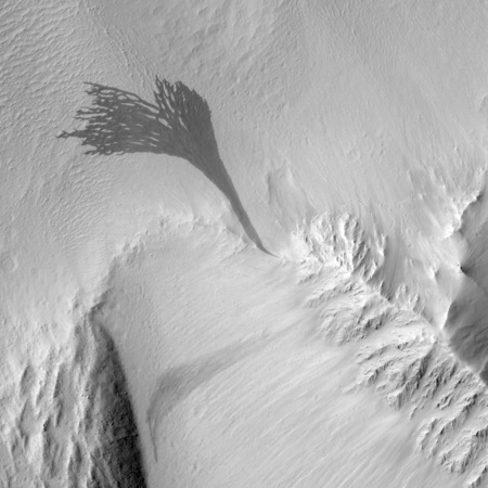
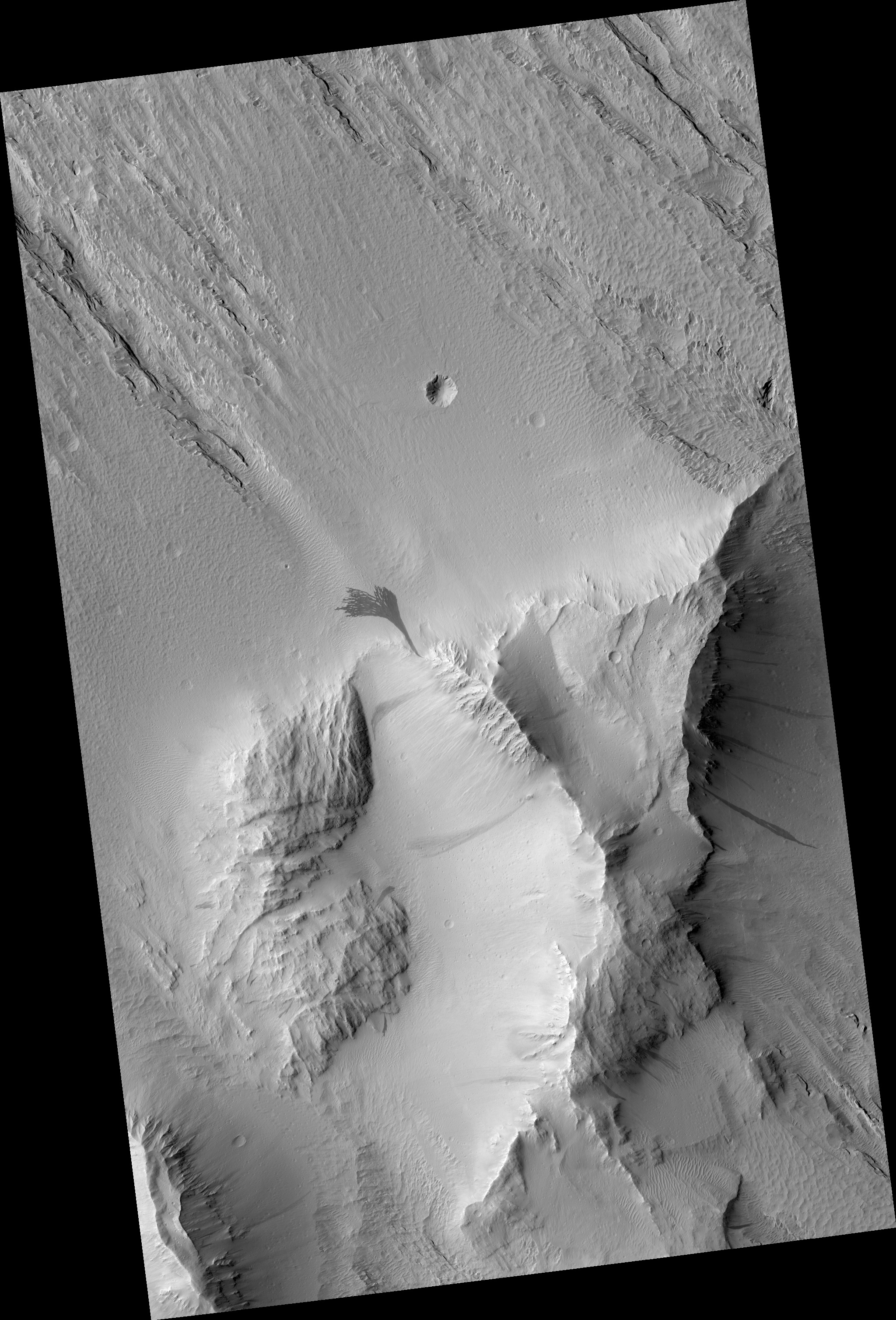
Cool image time! The image on the right, cropped to post here, comes from a Mars Reconnaissance Orbiter image that shows a massive relatively recent and dark slope streak that emanates out from a single point on the surface. (Note that the release at this link rotates the image so that north points down. I have rotated back so that north points up.)

Streaks form on slopes when dust cascades downhill. The dark streak is an area of less dust compared to the brighter and reddish surroundings. What triggers these avalanches is not known, but might be related to sudden warming of the surface.

These streaks are often diverted by the terrain they flow down. This one has split into many smaller streaks where it encountered minor obstacles. These streaks fade away over decades as more dust slowly settles out of the Martian sky.

Point of origin for flow

Location of flow, west of Olympus Mons

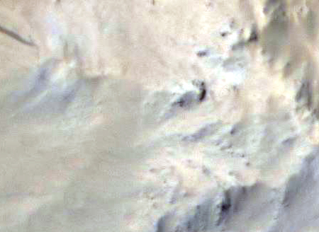
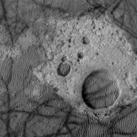
The MRO release focuses on the fingerlike breakup of the flow as it descends into sand-dune filled plain. What is more interesting to me is the terrain where this flow originated. A close-up of that area from the full image, shown on the right, reveals a feature that could be a wash running in line with the flow’s origin, and leading uphill to a dark feature that is a likely a cliff face. (The light in this image is coming from the southeast.)

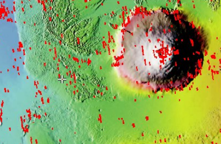
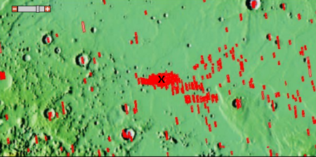
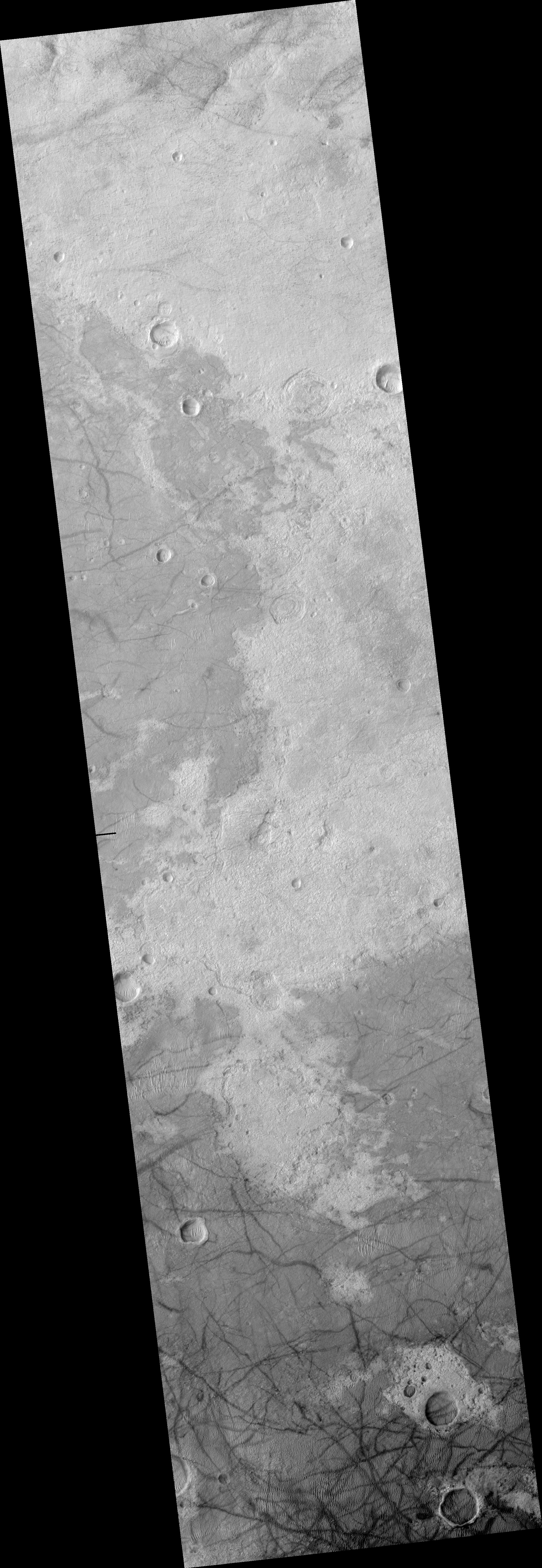
This location, at 15.2N latitude, 214.9E longitude and shown by the small cross in the image on the right and captured from this page, is west of Olympus Mons, the largest volcano on Mars. This suggests to me that the originating feature might be an outlet from a lava tube, from which water suddenly seeped out to produce this massive slope streak. A look at the mesa from which this flow came, cropped from the full image and posted below the fold, shows numerous similar slope streaks of varying ages flowing out of this mesa, with some very faint because they occurred farther in the past. Some are even within the bowl at the top of the mesa.

Whether these come from lava tubes is definitely unclear, and I suspect I will be told by geologists not likely. The seeps however do suggest strongly that this mesa might be a very good location for future colonists to look for underground water ice. Since clouds form on the western slopes of Arsia Mons, the southernmost of the three giant volcanoes to the east of Olympus Mons, and that past glacial activity has been documented there, I wonder if some of these same conditions might also exist here, on the nearby terrain west of Olympus Mons.
» Read more

4 comments

A good health check for Mars Reconnaissance Orbiter

Link here. The article outlines in good detail the spacecraft’s present condition, which is excellent despite being in space since 2005, as well as outlining the measures being taken to keep it operational into the 2020s.

This item is probably the biggest cause for concern:

For example, some HiRISE images taken in 2017 and early 2018 show slight blurring not seen earlier in the mission. The cause is under investigation. The percentage of full-resolution images with blurring peaked at 70 percent last October, at about the time when Mars was at the point in its orbit farthest from the Sun. The percentage has since declined to less than 20 percent. Even before the first blurred images were seen, observations with HiRISE commonly used a technique that covers more ground area at half the resolution. This still provides higher resolution than any other camera orbiting Mars — about 2 feet (60 centimeters) per pixel — and little blurring has appeared in the resulting images.

HiRISE is the spacecraft’s primary instrument, and its most valuable. If it goes, we will lose our best tool right now for looking in detail at the Martian surface.

0 comments

Mars rover update: February 8, 2018

Summary: Curiosity remains on Vera Rubin Ridge, though it has begun moving toward the point where it will move down off the ridge. Opportunity remains in Perseverance Valley, though it has finally taken the north fork down.

Before providing today’s update, I have decided it is time to provide links to all previous updates, in chronological order. This will allow my new readers to catch up and have a better understanding of where each rover is, where each is heading, and what fascinating things they have seen in the past year and a half.

These updates began when I decided to figure out the overall context of Curiosity’s travels, which resulted in my March 2016 post, Pinpointing Curiosity’s location in Gale Crater. Then, when Curiosity started to travel through the fascinating and rough Murray Buttes terrain in the summer of 2016, I stated to post regular updates. To understand the press releases from NASA on the rover’s discoveries it is really necessary to understand the larger picture, which is what these updates provide. Soon, I added Opportunity to the updates, with the larger context of its recent travels along the rim of Endeavour Crater explained in my May 15, 2017 rover update.

Now to talk about the most recent news from both rovers!
» Read more

1 comment

Curiosity takes a panorama that shows its entire journey so far

Cool image time! The Curiosity science team has released a panorama taken in October 2017 that looks north across the floor of Gale Crater and shows the rover’s entire journey since it landed in 2012.

Rather than post the image here, I have posted below the fold a video produced by the science team that pans across the entire panorama, and then shows where Curiosity has traveled in that panorama. Look close, and you will realize how truly little of Mars we have so far explored.
» Read more

1 comment

The landing site of NASA’s next Mars lander

InSight's landing site on Mars

InSight, NASA’s next Mars lander scheduled to launch later this year (two years late), is aiming for a landing site in a region called Elysium Planitia, a flat plain north of the equator.

InSight’s scientific success and safe landing depends on landing in a relatively flat area, with an elevation low enough to have sufficient atmosphere above the site for a safe landing. It also depends on landing in an area where rocks are few in number. Elysium Planitia has just the right surface for the instruments to be able to probe the deep interior, and its proximity to the equator ensures that the solar-powered lander is exposed to plenty of sunlight.

The target area is centered at 4.5 N latitude and 135.9 East longitude. If you zoom in on that latitude and longitude at the archive of Mars Reconnaissance Orbiter (MRO) high resolution images, you get the red blob on the right, which shows how many images they have taken of this area in preparation for InSight’s mission. The X indicates the location of lat/long above.

Below the fold is a reduced version of the MRO image for the center of this target area. The black spots near the center are thought to be a recent crater impact site. In general, this image shows an area with more features than the region around it. Most of the landing area of Elysium Planitia is a featureless flat plain with scattered small craters. Since InSight is not a rover, where it lands will be where it does its research, so there was no reason to pick a site with lots of interesting surface features. Moreover, since InSight is focused not on studying the surface but the interior geology of Mars, it matters little what the surface looks like anyway. One instrument will be a seismograph, while another will insert a thermometer about sixteen feet into the ground to measure the interior temperature.
» Read more

1 comment

Weird Martian geology: Kaiser Crater

Kaiser Crater bedrock

Cool image time! This week JPL’s image site highlighted a picture taken by Mars Odyssey of the floor and dunes inside Kaiser Crater, located to the west of Helles basin in an area dubbed the Noachis Region.

To my eye, the Mars Odyssey picture was interesting, but not worth a post here on Behind the Black. However, I decided to take a look at what HiRise, the high resolution camera of Mars Reconnaissance Orbiter (MRO), had taken of the same area, just out of curiosity. A search at the master HiRise image site at the same latitude and longitude (-45 latitude, 180 longitude) showed that HiRise had imaged a part of the same area, but at much higher resolution.

When I zoomed in on this hi resolution image I came across some interesting and weird geology, cropped to show here on the right. Now this, I thought, is worth posting. Notice how the dark tracks, caused by dust devils, leave no tracks as they cut across the brighter areas. Obviously, these bright areas have no dust or sand, and are likely solid bedrock of some kind. The depressions might be craters, but they also might not. The raised area around the depressions might have been caused by the impact, or it might have been caused by some internal geological process that caused the depression while also raising the surrounding bulge. Since then the wind has been steadily depositing sand in the depressions, causing it to get trapped there.

7 comments
1 156 157 158 159 160 212