
It’s Cold and Wet at the Moon’s South Pole
New results from the LCROSS impact on the Moon’s south pole: It’s cold and wet at the Moon’s south pole.
Update: Other elements detected in the impact plume included silver and mercury.
New results from the LCROSS impact on the Moon’s south pole: It’s cold and wet at the Moon’s south pole.
Update: Other elements detected in the impact plume included silver and mercury.
The Moon stinks of gunpowder.
The possibilities for China’s Chang’e 2 lunar probe include travel far beyond the Moon.
The various partners running the ISS are considering using it as a platform to launch an orbital manned mission to the Moon.
China’s new lunar orbiter, Chang’e 2, has arrived in lunar orbit.
Digitally remastered footage of the original television recordings from the Apollo 11 mission have been unveiled in Australia.
The Lunar X Prize award for putting the first privately funded robot on the Moon by 2012 is now set at $30 million.
The second Chinese probe to the Moon did more than take off on Friday. It also rained pieces of metal down on a Chinese villages in Suichuan County, Jiangxi, China.
China has launched its second unmanned lunar probe, designed to photograph the Moon from an orbit altitude of 9 miles.
The launch of China’s next lunar probe, Chang’e 2, could occur as soon as this Friday.
Lost video footage of Neil Armstrong’s first step on the Moon found in Australia.
Too much water on the Moon?
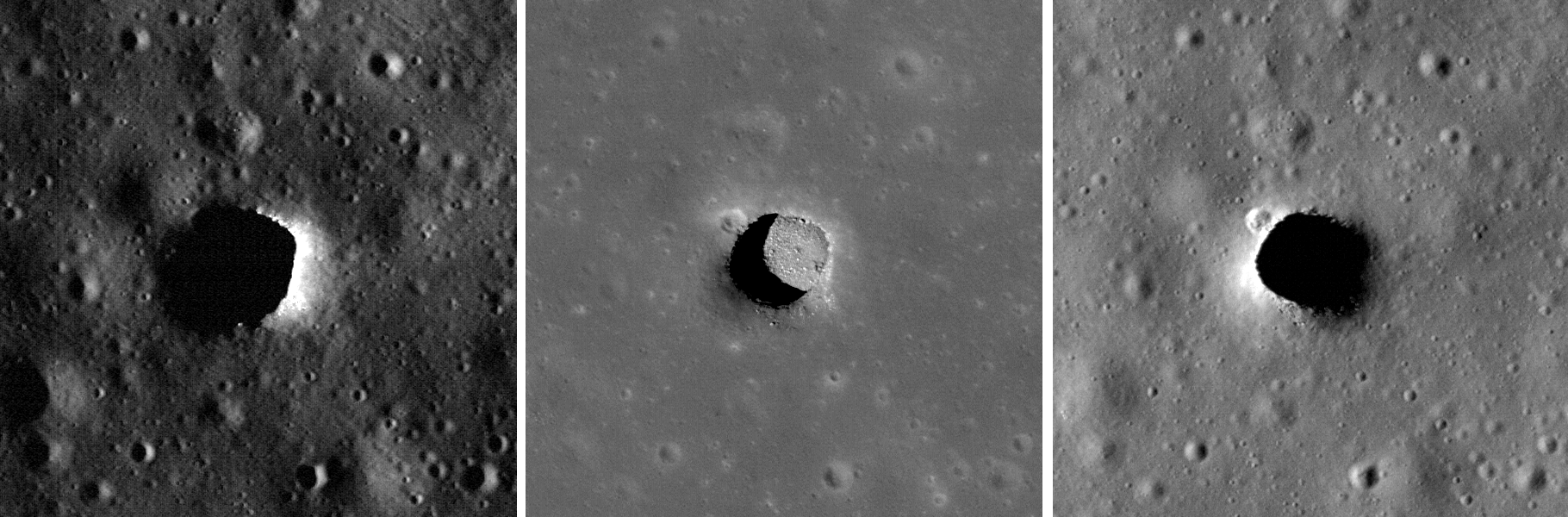
Check out these newly posted images of lunar cave pits, taken by Lunar Reconnaissance Orbiter. The depth estimates range from 100 to 300 plus feet.
[Ed. I should note that some of these images have already been posted on behindtheblack. For example, the center image found here) was first discovered by reader James Fincannon and posted by me on July 15 and July 26, when I discussed the challenges of accessing the bottom of these pits. I also posted an image of the Mare Ingenii pit on July 13.]
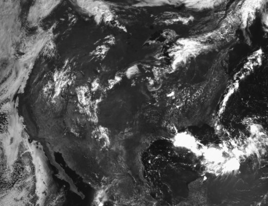
On August 9, 2010 the camera on Lunar Reconnaissance Orbiter took some routine calibration images and captured the Earth from lunar orbit, showing the western hemisphere with relatively little cloud cover. The picture below is a tiny piece from that global image, cropped to show the United States. The details are pretty remarkable, considering the distance. You can explore the full global image in detail here.
New results from Lunar Reconnaissance Orbiter, including a new global topographic map.
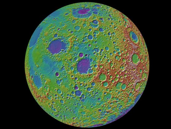
From the caption: A lunar topographic map showing the Moon from the vantage point of the eastern limb. On the left side of the Moon seen in this view is part of the familiar part of the Moon observed from Earth (the eastern part of the nearside). In the middle left-most part of the globe is Mare Tranquillitatis (light blue) the site of the Apollo 11 landing, and above this an oval-appearing region (Mare Serenitatis; dark blue) the site of the Apollo 17 landing. Most of the dark blue areas are lunar maria, low lying regions composed of volcanic lava flows that formed after the heavily cratered lunar highlands (and are thus much less cratered).
University of Arizona scientists have built a hydroponic lunar vegetable garden on Earth. More information here. Key quote:
The membrane-covered module can be collapsed to a four-foot-wide disk for interplanetary travel. It contains water-cooled sodium vapor lamps and long envelopes that would be loaded with seeds, ready to sprout hydroponically.
Paul Spudis at Air and Space magazine has some more thoughts about the origins of that natural bridge on the Moon that Lunar Reconnaissance Orbiter photographed recently.
Set to launch before year’s end, construction of China’s next lunar probe, Chang’e 2, appears to be on schedule, at least according to Chinese news sources.