A new map of the water ice on Mars

Annotated water ice map of Mars
Click for full resolution image.

In a new science paper planetary scientists have produced a new global map of the water ice of Mars, based on data from Mars Reconnaissance Orbiter (MRO) and Mars Odyssey.

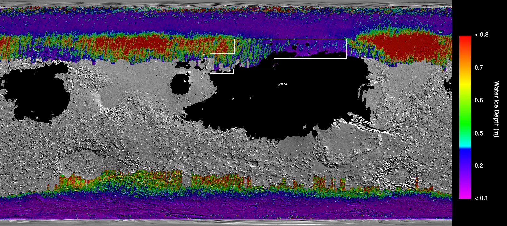
The image above is a lower resolution version of that map, annotated by me. The black areas are regions covered with a thicker layer of dust, so no good data was obtained. As you go from red to green to blue to purple the ice is thought to be closer to the surface, with the depth as small as an inch in the dark purple areas. The white rectangular represents the region best for human settlement, as it has ice near the surface and is at lower latitudes.

The red box indicates the location in Arcadia Planitia that is SpaceX’s candidate landing zone for Starship. Based on this new water ice map it appears that SpaceX has chosen very well. And the scientists who wrote this paper agree, as noted in the press release: “A large portion of a region called Arcadia Planitia is the most tempting target in the northern hemisphere.”

The map also confirms the existence of the 30 to 60 degree latitude bands where scientists believe a lot of buried glaciers exist. Both bands are both very evident in this new map.

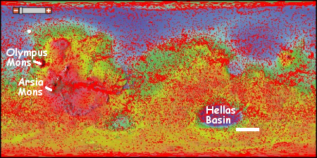
To provide some further context, below is a global map of Mars labeled to show its major geographic features as well as the locations of all previous and upcoming landers/rovers, rearranged to match the water ice map above.
» Read more

The known ice cliffs on Mars

Last week there was a big NASA story about the discovery of eight locations on Mars where the evidence strongly suggests that these spots have cliff faces with exposed layers of water ice.

The press release however did not provide an overview about where those eight locations were. Only two locations were given, one for a scarp in Milankovič Crater in the northern hemisphere, and one in an area called Promethei Terra, located in the remote cratered highlands in the southern high-mid-latitudes.

The location of known ice scarps on Mars

After much digging (and some assistance from John Batchelor) I was finally able to obtain the latitudes and longitudes of all 8 locations. All but the scarp in Milankovič Crater crater (shown by the white dot north of Olympus Mons) are located in the white rectangular box shown to the south and east of Hellas Basin, the area with Mars’ lowest elevation. This part of Mars is not well imaged with the high resolution camera on Mars Reconnaissance Orbiter (indicated by the fewer number of red squares in the image), mostly because it appears relatively boring from a distance. Nothing appears to be there for hundreds and hundreds of miles except craters, sand, and sand dunes..

The discovery of these scarps in this area however changes the picture. It suggests that cratered highlands that surround Hellas Basin, including those close to the planet’s equator, could contain similar buried layers of ice. More research is necessary to pin down more locations, especially those closer to the equator where conditions might be more hospitable for a colony.

Moreover, educated readers of Behind the Black have previously noted that because of Hellas Basin’s low elevation the air pressure there is thicker, and therefore the location has some advantages as a potential colony location. These ice scarps raise the value of Hellas Basin considerably, as they suggest that such layers could easily be exposed as you descend into Hellas Basin. If such layers are exposed on the northern flanks of the basin, they would be at latitudes of around 25 to 30 degrees south, a much more friendly latitude for settlement.

Exposed mid-latitude ice deposits found on Mars

Scientists have discovered eight locations on Mars where underground ice appears to be exposed on cliff faces

The scarps directly expose bright glimpses into vast underground ice previously detected with spectrometers on NASA’s Mars Odyssey orbiter, with ground-penetrating radar instruments on MRO and on the European Space Agency’s Mars Express orbiter, and with observations of fresh impact craters that uncover subsurface ice. NASA sent the Phoenix lander to Mars in response to the Odyssey findings; in 2008, the Phoenix mission confirmed and analyzed the buried water ice at 68 degrees north latitude, about one-third of the way to the pole from the northernmost of the eight scarp sites.

The important thing about this discovery is that, though we have known for several years that water ice exists underground in the Martian mid-latitudes, this is the first time we have identified specific places there it is exposed and accessible.

Unfortunately, the press release does not provide the specific eight locations, except for the one image, which is located in the southern hemisphere in a region called Promethei Terra, far from areas that have been studied much more extensively. I will do some digging to see if I can identify the other seven locations.

Ice and volcanoes on ancient Mars?

New data of past volcanic activity on Mars suggest that the red planet was once covered by at least one extensive ice sheet.

There is a great deal of uncertainty in this conclusion, however. They have found one example with the right geology to suggest past ice sheets under which volcanoes erupted. Translating this into an extensive ice sheet requires many assumptions that might not prove true with further research.

Did the Moon’s axis shift 3.5 billion years ago?

The uncertainty of science: Because the concentrations of ice on the moon are thought to be located on opposite sides of the planet, both locations 5.5 degrees away from the poles, a team of scientists has proposed that these locations were once the Moon’s poles and that the axis got shifted 3.5 billion years ago when a gigantic volcanic hotspot on the surface erupted.

He and his colleagues assumed that when the ice was deposited, it was centered on the poles. But what kind of event could have moved the poles by 5.5°? Known asteroid impacts were too small or in the wrong location to do the job. Instead, the team hypothesizes that a 3.5-billion-year-old hot spot could have nudged the poles to their present-day position. Pouring out enormous amounts of lava, that hot spot created Oceanus Procellarum, the vast dark spot on the near side of the moon. The Procellarum region is known to have high concentrations of radioactive elements that would have been hot in ancient times. The research team theorizes that this heat would have created a less dense lens in the moon’s mantle that would have caused the axis to wobble into today’s position.

This theory requires that the Moon’s ice is at least this old, which is quite a stretch. Also, if the Procellarum eruption caused a pole shift, I wonder why the other large lunar eruptions, which created the Moon’s other mare, did not shift the poles further and in other directions.

Water Ice in Shackleton Crater?

Ice in Shackleton?

New results from the radar instrument on Lunar Reconnaissance Orbiter (LRO) has found evidence of water-ice on the slopes of Shackleton Crater, located at the Moon’s south pole. The paper, published on Saturday in Geophysical Research Letters – Planets, suggested that about 5 to 10 percent of the weight of the material on the slopes of the crater is comprised of water ice, to depths of 6 to 10 feet.

The box on the upper left in the image to the right shows the data from a radar sweep of the crater taken on April 18, 2010, and compares that to five computer models. As you can see, the data here most closely matches the 5% ice model. Two other sweeps showed similar results.

The water-ice, if there, is not in slabs of ice, as sometimes portrayed in the press, but would be mixed into the Moon’s regolith, or “topsoil”, and would have to be processed out like ore to be useful. Or to quote the paper’s conclusion:

The fundamental conclusions made with high resolution, ground based radar of Shackleton remain unaltered — that no large-scale, meters thick ice deposits are evident within the crater. Rather, Mini-RF data are consistent with roughness effects or with a small percentage of water-ice deposits admixed into the uppermost 1-2 meters of silicate regolith within Shackleton, possibly accounting for the observations made by the Clementine bistatic experiment.

Several points:
» Read more

Water on the Moon? The battle continues

LEND data of lunar south pole

A little over a month ago I reported here on Behind the Black some recent results from the LEND instrument on Lunar Reconnaissance Orbiter (LRO) that had found significantly less water in the permanently shadowed craters at the lunar poles than previously thought. To quote again from that paper’s abstract, which I will henceforth refer to as Sanin, et al:

This means that all [permanently shadowed regions], except those in Shoemaker, Cabeus and Rozhdestvensky U craters, do not contain any significant amount of hydrogen in comparison with sunlit areas around them at the same latitude.

And from the paper’s conclusion:

[E]ven now the data is enough for definite conclusion that [permanently shadowed regions] at both poles are not reservoirs of large deposits of water ice.

Paul Spudis of the Lunar and Planetary Institute in Houston, Texas and one of the world’s top lunar scientists then commented as follows:

You neglect to mention yet another possibility — that this paper and its conclusions are seriously flawed in almost every respect. The veracity of the LRO collimated neutron data [produced by the LEND instrument] have been questioned on serious scientific grounds. Other data sets (spectral, radar) suggest significant amounts of water at both poles, billions of metric tons in total.

Spudis also discussed this scientific dispute at length on his own blog.

When I read Dr. Spudis’s comment I immediately emailed William Boynton of the Lunar and Planetary Laboratory at the University of Arizona, one of the authors of the Sanin et al paper, to get his reaction. Today he sent me the following detailed explanation, describing the basis of the controversy and why he believes the LEND data is valid.
» Read more

If there is water ice on the Moon, scientists have found that the bombardment from interstellar cosmic rays has likely caused chemical reactions that “can create complex carbon chains similar to those that help form the foundations of biological structures.”

Life stranger than science fiction: If there is water ice on the Moon, scientists have found that the bombardment from interstellar cosmic rays has likely caused chemical reactions that “can create complex carbon chains similar to those that help form the foundations of biological structures.”

Studying the Moon by starlight

The Moon's south pole by starlight

In a paper published today in the Journal for Geophysical Research, Planets, the science team for Lunar Reconnaissance Orbiter describe how they have used starlight to peer into the permanently shadowed craters of the Moon’s north and south poles. Looking only during the lunar night, they measured the dim albedo of the Moon from reflected starlight. From this very weak signal they were able to cull two interesting facts about these very cold and very dark places.

  • The ground at the bottom of these craters is more porous than the surrounding unshadowed terrain.
  • There is evidence in the spectroscopy of 1 to 2% water frost in these craters.

» Read more

Prime real estate

The south pole of the moon

Since the 1990s, scientists have suspected that water-ice might be hidden in the forever-dark floors of the polar craters on the Moon. If so, these locations become valuable real estate, as they not only would provide future settlers water for drinking, the water itself can be processed to provide oxygen and fuel.

Moreover, the high points near these craters, including the crater rims, are hoped to be high enough so that the sun would never set or be blocked by other mountains as it made its circuit low along the horizon each day. If such a place existed, solar panels could be mounted there to generate electricity continuously, even during the long 14-day lunar night.

Below the fold is a six minute video, produced from images taken by Lunar Reconnaissance Orbiter (LRO) from February 6, 2010 to February 6, 2011, in an effort to find out if such a place actually exists. It shows how the sunlight hits the south pole across an entire year.
» Read more