More Webb images released
Click for full image.
As planned, NASA this morning released four new science images from the James Webb Space Telescope, in addition to the deep field image released yesterday.
All are spectacular, with each producing new information not previously observed. To see the Stephen’s Quintet image go here. For the exoplanet data, showing the presence of water in its atmosphere, go here. For the Carina nebula image, go here.
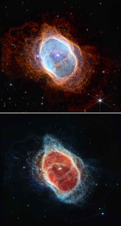
The image to the right, reduced to post here, shows the Southern Ring Nebula as taken by two Webb cameras in different infrared wavelengths. From the press release:
Two stars, which are locked in a tight orbit, shape the local landscape. Webb’s infrared images feature new details in this complex system. The stars – and their layers of light – are prominent in the image from Webb’s Near-Infrared Camera (NIRCam) [at the top], while the image from Webb’s Mid-Infrared Instrument (MIRI) on the [bottom] shows for the first time that the second star is surrounded by dust. The brighter star is in an earlier stage of its stellar evolution and will probably eject its own planetary nebula in the future.
In the meantime, the brighter star influences the nebula’s appearance. As the pair continues to orbit one another, they “stir the pot” of gas and dust, causing asymmetrical patterns.
Because this is an infrared image, the colors are not natural, but were assigned based on the slightly different infrared wavelengths produced by the object’s different features. From the image’s webpage:
Several filters were used to sample narrow and broad wavelength ranges. The color results from assigning different hues (colors) to each monochromatic (grayscale) image associated with an individual filter.
Eventually astronomers will use Webb to look at many astronomical objects that Hubble has been observing for the past thirty years, adding a high resolution infrared view that will add to Hubble’s views.

Click for full image.
As planned, NASA this morning released four new science images from the James Webb Space Telescope, in addition to the deep field image released yesterday.
All are spectacular, with each producing new information not previously observed. To see the Stephen’s Quintet image go here. For the exoplanet data, showing the presence of water in its atmosphere, go here. For the Carina nebula image, go here.
The image to the right, reduced to post here, shows the Southern Ring Nebula as taken by two Webb cameras in different infrared wavelengths. From the press release:
Two stars, which are locked in a tight orbit, shape the local landscape. Webb’s infrared images feature new details in this complex system. The stars – and their layers of light – are prominent in the image from Webb’s Near-Infrared Camera (NIRCam) [at the top], while the image from Webb’s Mid-Infrared Instrument (MIRI) on the [bottom] shows for the first time that the second star is surrounded by dust. The brighter star is in an earlier stage of its stellar evolution and will probably eject its own planetary nebula in the future.
In the meantime, the brighter star influences the nebula’s appearance. As the pair continues to orbit one another, they “stir the pot” of gas and dust, causing asymmetrical patterns.
Because this is an infrared image, the colors are not natural, but were assigned based on the slightly different infrared wavelengths produced by the object’s different features. From the image’s webpage:
Several filters were used to sample narrow and broad wavelength ranges. The color results from assigning different hues (colors) to each monochromatic (grayscale) image associated with an individual filter.
Eventually astronomers will use Webb to look at many astronomical objects that Hubble has been observing for the past thirty years, adding a high resolution infrared view that will add to Hubble’s views.