
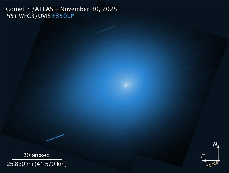
Terran Orbital wins contract to build cubesat to go to Apophis with ESA’s Ramses probe
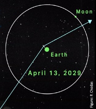
A cartoon (not to scale) showing Apophis’s
path in 2029.
The satellite company Terran Orbital, owned by Lockheed Martin, has won a contract from the European Space Agency (ESA) to build a cubesat to fly with its Ramses probe that will launch in 2028 and rendezvous with the potentially dangerous asteroid Apophis when it makes its very close fly-by of the Earth on April 13, 2029.
The CubeSat is named after Italian scientist Paolo Farinella and is backed by the Italian Space Agency. After successfully completing the Critical Design Review in January 2026, Tyvak International [a subsidiary of Terran Orbital] will begin the implementation phase, with launch currently planned for 2028.
…Operating aboard the RAMSES spacecraft, developed by OHB Italia, the Farinella CubeSat will be one of two spacecraft deployed to explore the asteroid’s subsurface using low-frequency radar. The satellite will also carry Horus, an optical instrument that acts as both a science imager and navigation camera, and Vista, a dust detector previously flown on the Milani CubeSat from ESA’s Hera mission.
Apophis is estimated to be about 1,200 feet across. When it does its fly-by in ’29 it will get within 20,000 miles of the Earth, dipping within the orbits used by geosynchronous satellites. It will then pass within 60,000 miles of the Moon. At its closest it will for a short time be visible to the naked eye.
Apophis’ orbit means that it has the potential in the next century or so to impact the Earth. This particular fly-by is significant because the Earth/Moon’s gravity will change the asteroid’s path in an unpredictable manner that could either increase or decrease that impact possibility on future fly-bys. And we won’t know until after the fly-by is complete.


