Martian crater overwhelmed by glacier?

Martian crater overwhelmed by glacier?
Click for full image.

Cool image time! The photo to the right, rotated, cropped, and reduced to post here, was taken on January 28, 2022 by the high resolution camera on Mars Reconnaissance Orbiter. It shows what the science team labels a “modified crater.”

What I see is an old crater almost completely covered by glacial material. That material however is also very old, as there are numerous small craters on its surface, enough that it must have been here for a long time. Its cracked surface also suggests this glacier is very old.

Thus, while we might have ice here, buried by a thin layer of dust and debris to prevent it from sublimating away, it must be very old ice. The many climate cycles caused by the extreme swings in Mars’ rotational tilt, from 11 to 60 degrees, have apparently not caused this ice to ebb and flow very much.

Might it therefore not be ice, but hardened lava?

The location, as shown by the overview map below, provides some context, but only makes this mystery more puzzling.
» Read more

Scientists: Yutu-2 spots tiny glass globules similar to those found by Apollo astronauts

According to a paper just published Chinese scientists running the Yutu-2 rover on the far side of the Moon have spotted several tiny glass globules similar to those found by Apollo astronauts.

Xiao and his team believe the small spheres, which are between 0.59 and 0.79 inches (1.5 to 2.5 centimeters) across, were probably formed by relatively recent meteor impacts. Specifically, the researchers believe that the globules formed from anorthosite, a volcanically-formed rock rich in the mineral feldspar, after a high-energy impact melted the rock and reformed into spheres.

In appearance these Yutu-2 globules appear translucent, unlike the Apollo globules which were either dark or opaque. Since the rover did not do spectroscopy on these objects before moving on, however, their actual make-up is unknown, with the speculations by the researchers above merely that, speculations, though reasonable.

Scientists: Martian topography in one region suggests the past existence of lakes and river networks, but not a large single ocean

Based on a just published paper, scientists using orbital topography data and imagery have concluded that more than three billion years ago on Mars ancient rivers in the transition zone between the southern cratered highlands and the northern lowland plains fed into numerous lakes in the lowlands, not a single large ocean as some scientists posit.

From their abstract:

The northern third of Mars contains an extensive topographic basin, but there is conflicting evidence to whether it was once occupied by an ocean-sized body of water billions of years ago. At the margins of this basin are the remnants of deltas, which formed into water, but the size and nature of this water body (or water bodies) is unclear, and detailed investigations of different regions of the basin margins are necessary.

In this study, we use high-resolution image and topographic datasets from satellites orbiting Mars to investigate a series of water-formed landforms in the Memnonia Sulci region, set along the boundary of Mars’s northern basin. These landforms likely formed billions of years ago, providing evidence for ancient rivers and lakes in this region. The geologic evolution of these rivers and lakes was complicated, likely influenced by water-level fluctuations, changes in sediment availability, and impact cratering. Our topographic analysis of these rivers and lakes suggests that they terminated in a series of ancient lake basins at the boundary of Mars’s northern basin, rather than supplying a larger, ocean-sized body of water. [emphasis mine]

Overview map

The Memnonia Sulci region is in the cratered highlands just south of the Medusae Fossae Formation, the largest volcanic ash deposit on Mars. The region of study in it is marked by the blue dot in the overview map to the right.

The study does not preclude the possible existence of a northern ocean on Mars, but it says that at least in this region at the equator, it did not exist. Instead, the various river valleys drained into separate smaller and relatively short-lived lakes.

Curiosity images the Martian version of a cave formation

An helictite on Mars?
Click for full image.

Cool image time! The photo to the right, cropped and reduced to post here, was taken today by Curiosity’s Mars Hand Lens Imager (MAHLI), a camera designed to get close high resolution images of very small features on the surface.

The Curiosity image site does not provide a scale, but MAHLI, located at the end of the rover’s robot arm, is capable of resolutions as small as 14 microns per pixel. Since a micron is one thousandth of a millimeter, and the original image was 1584 by 1184 pixels in size, that means the entire image is likely only slightly larger than 18 to 25 millimeters across, or slightly less than an inch.

This feature, which closely resembles a cave helictite, is thus about a quarter inch in size. Helictites, which in caves often resemble wildly growing roots, are nonetheless made of calcite, not organic material. They grow wildly because the water is being pushed out from their center is under pressure, so that as it drips away from the formation it leaves its calcite deposits randomly, causing the formation to grow randomly.

MAHLI also took what looks to be an infrared or heat image of the formation, which appears to show that the tips of the branches are at a different temperature, I think cooler, than the rest of the formation.

While seeping water causes helictites on Earth, what formed this thing on Mars is beyond my guess. It sure looks cool however.

Dry barren ground in Martian northern lowlands?

Dry barren ground in the Martian northern lowlands?
Click for full image.

Today’s cool image is intriguing because of what appears to not be there, rather than what is there. The photo to the right, cropped and reduced to post here, was taken on November 3, 2021 by the high resolution camera on Mars Reconnaissance Orbiter (MRO).

At first glance it appears to show a very dry, barren surface. At its base are many parallel grooves running from the southwest to the northeast. On top of these grooves are several more recent crater impacts, as well as several patches of higher bedrock that appears to have been hard enough to resist whatever erosion process caused the groves.

Yet, based on the overview map below, the location of this photo should not be dry and barren, but instead home to a near-surface ice sheet covering everything.
» Read more

Curiosity’s coming travels across the rocky Greenheugh Pediment

Curiosity's view west on February 21, 2022 (Sol 3393)
Click for full resolution panorama. Original images can be found here, here, and here.

Overview map
Click for interactive map.

Curiosity, having successfully climbed up and out of Gordon Notch, was able to aim its navigation cameras forward yesterday and get its first views from this position across the very rocky Greenheugh Pediment to its next major goal, Gediz Vallis Ridge. The panorama above, taken by the rover’s right navigation camera, shows this view. The ridge is about 1,500 feet away, at its closest point. The rim of Gale Crater, barely visible in the haze, is about 20-30 miles away.

The overview map to the right indicates the area covered in this panorama by the yellow lines. The red dotted line indicates Curiosity’s planned future route.

Curiosity’s first view of the pediment was made in March 2020, from a point on its northern border, just beyond the top edge of the map. The panorama taken then showed what appeared to be a very treacherous and rough surface, possibly too rough for Curiosity to traverse.

According to the science team’s most recent update from before the holiday weekend, the plan had been to spend February 19-20 studying the ground, then drive a short distance yesterday to get a better view ahead.

This will give us a good vantage point to look into the valley ahead and try to scope out our future route. … We chose to drive about 10m total, in order to get the rover oriented at a good heading and parked in a good spot. We expect a similarly beautiful view from our post-drive imaging.

That view is the panorama above. Though still very rough, the ground ahead appears far more traversable than the surface seen in 2020.

Deformed Martian craters

Deformed Martian craters
Click for full image.

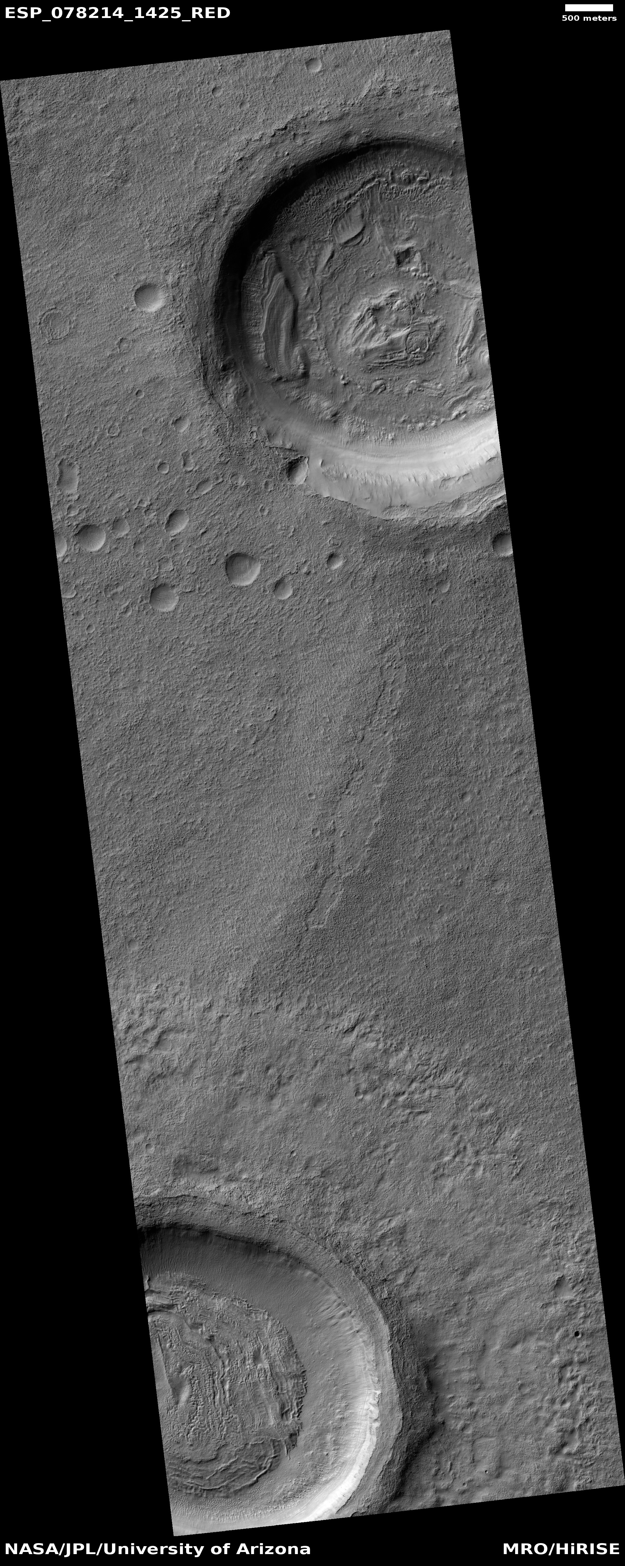
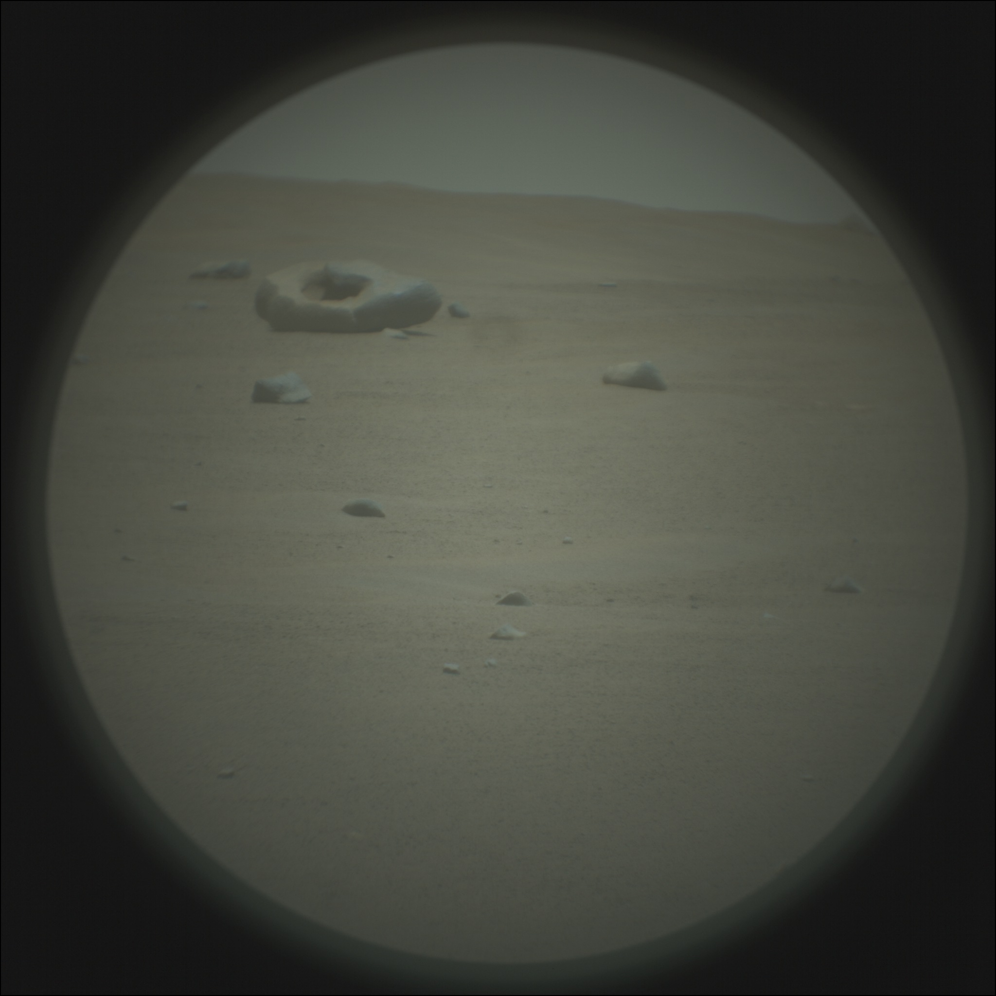
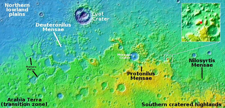
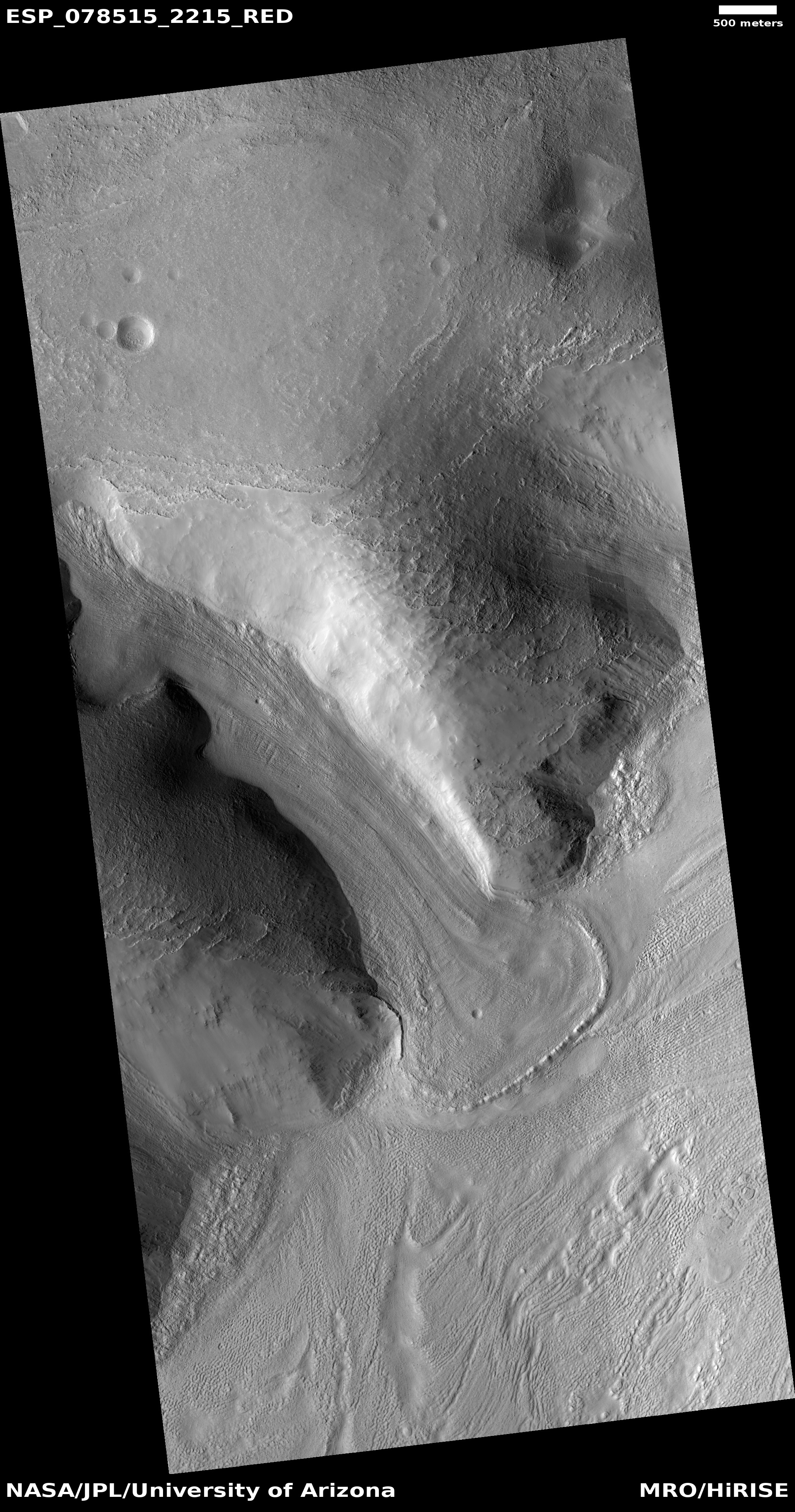
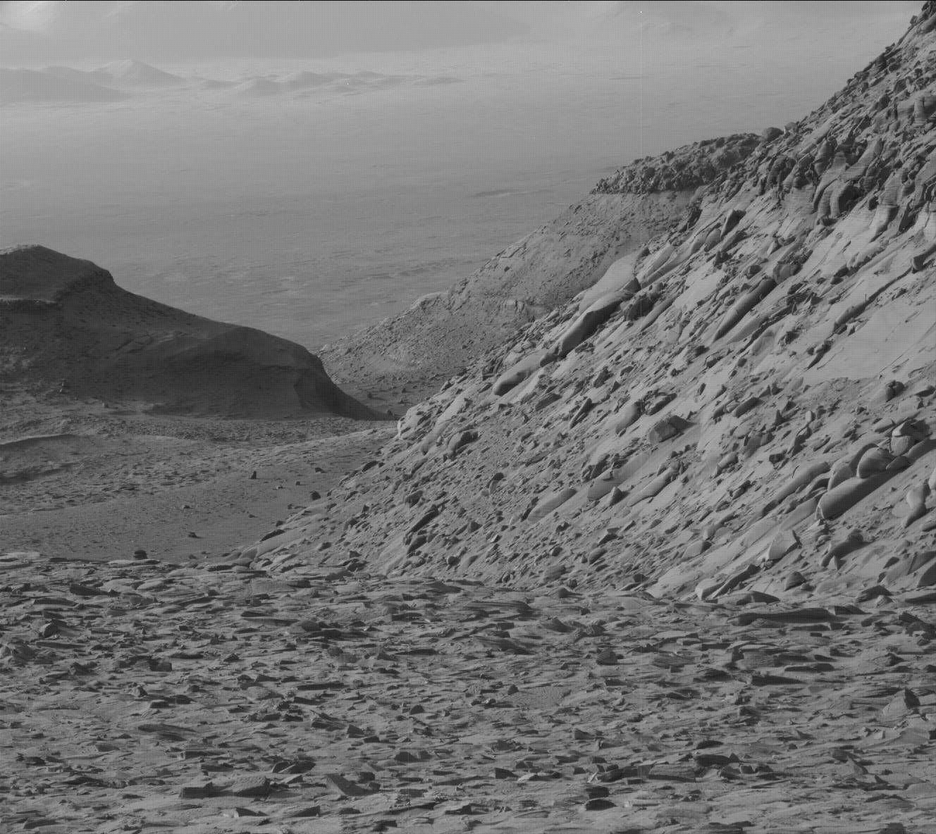
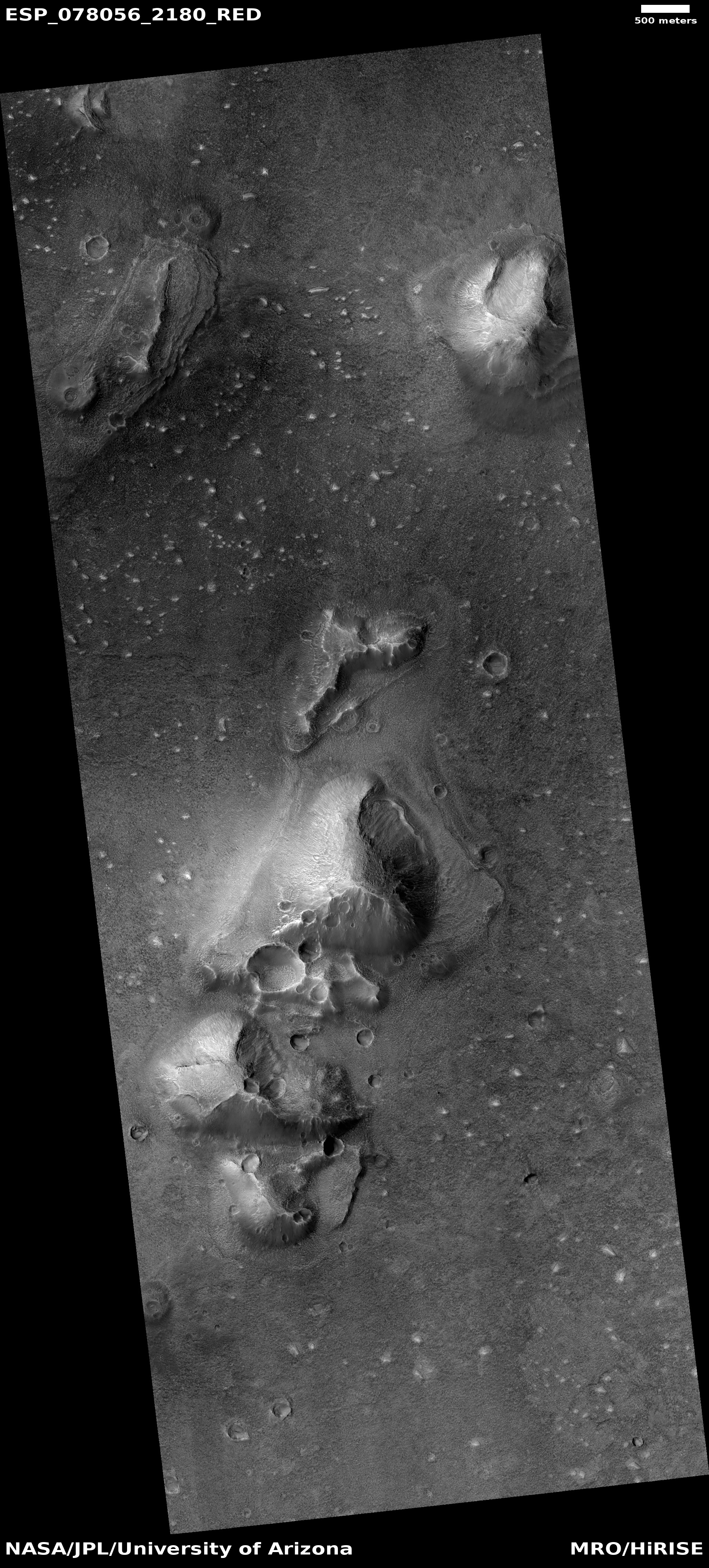
Cool image time! The picture to the right, rotated, cropped, and reduced to post here, was taken on September 3, 2021 by the high resolution camera on Mars Reconnaissance Orbiter (MRO). The focus of the image for the MRO science team were the wedding cake layers inside the largest crater. These layers suggest glacial ice, with the layers suggesting multiple cycles of glacial ebb and flow. Since the crater is at 43 degrees north latitude, and sits in the chaos region dubbed Protonilus Mensae, smack dab in the center of what I call Mars’ glacier country, this conclusion makes perfect sense.

To my eye, however, the most interesting feature of this photo are the many distorted craters. The overview map below shows the picture’s location, as well as several nearby very large impact craters which might have caused many secondary impacts, including the many craters at this location.
» Read more

Cracking ice on Mars?

Cracking ice on Mars?
Click for full image.

Cool image time! The photo to the right, cropped and reduced to post here, was taken on December 7, 2021 by the high resolution camera on Mars Reconnaissance Orbiter (MRO). It shows what the MRO science team dubs “erosion of scalloped terrain” in the northern lowland plains of Mars.

The cracks invoke the polygon cracks one sees in mud as it dries. The circular feature suggests a buried crater whose shape is merely suggested because the cracks are conforming to the underground topography.

Are we looking at dried mud? Maybe, but more likely we are seeing a sheet of ice now sublimating away and cracking as it does so. If you look at the full photo you will see the cracked material also appears to drape itself over several nearby low ridges, something that seems more likely from ice than mud.

The overview map below also suggests this is a buried layer of ice.
» Read more

Curiosity looks out across the mountains

Curiosity panorama, Sol 3387, February 15, 2022
Click for high resolution. Original images found here and here.

Overview map
Click for interactive map.

Cool image time! The mosaic above, created from two photos taken by Curiosity’s left navigation camera and downloaded from the rover today, looks to the southeast across the small rocky valley the rover has been traversing for the past two months towards Mount Sharp.

The rover had entered this valley through the nearest gap on the left, then traveled uphill from the left to the right until it had passed behind the nearest dark ridge on the right. It then retreated and turned left, starting uphill through Gordon Notch, as shown in the overview map to the right.

On the overview, the white line marks Curiosity’s past travels, with red dotted line indicating its planned future route. The yellow lines indicate the approximate view in the panorama above.

For scale, Navarro Mountain is about 450 feet tall. The actual peak of Mount Sharp is blocked by the white front range to the left. The rover is presently still 12,600 feet below that peak, which sits to the southeast about 35 miles away.

A floating Martian rock

Mosiac of top of butte
For original images, click here and here.

A floating Martian rock
Click for original photo.

Cool image time! As Curiosity begins the slow and careful journey up through the rocky Gordon Notch onto the even rockier Greenheugh Pedimont layer above, the science team is using its cameras to take pictures of the buttes that form the northern and southern walls of that notch.

The mosiac above and the photo to the right, both cropped and reduced to post here, is one beautiful example. Taken by Curiosity’s high resolution camera on February 11th, both images show the consequences on geology of Mars’ low gravity, one third that of Earth’s. The top image shows the entire top of the butte, with the picture to the right focusing on one boulder that almost seems to be floating in the air. Look close and you can see daylight under the rock’s entire left half.

I think this butte is the north wall of Gordon Notch, but am not sure. Either way, the photos once again demonstrate that it is very dangerous to assign our Earth-based assumptions to Martian geology. There may be similarities, but the differences must not be ignored, or else our conclusions about what we see will be wrong.

Global image of Mars from UAE’s Al-Amal orbiter

Mars as seen by Al-Amal in January 2022
Click for original image.

Cool image time! The United Arab Emirates (UAE) today released several new images taken by its Al-Amal Mars orbiter, showing the changing atmospheric conditions on Mars between September ’21 and January ’22.

The photo to the right, cropped and annotated by me, is the January image, showing the dust storm conditions that presently exist in the equatorial regions of Mars. The lighter puffy cloud-like features in the center of the image are a 1,500 mile wide dust storm centered on the equator. The white dot indicates the approximate spot where Perseverance sits in Jezero Crater, within that storm.

The previous Al-Amal image from September (available at the link) shows the whole Martian hemisphere with generally clear skies.

Below is a recent photo taken by Perseverance illustrating these dusty conditions.
» Read more

Parker images the surface of Venus

Parker image compared to radar maps of Venus
For original images go here and here.

During its flybys of Venus in July 2020 and February 2021 the Parker Solar Probe used its wide field camera to take images of the night side of Venus in red optical and near infrared wavelengths, essentially measuring the heat (in the range of 863 degrees Fahrenheit) being emitted by the planet’s surface.

The resulting images, the first orbital photos of Venus’ surface in the optical, showed continent-sized surface details that matched previously made radar maps, and confirmed as expected that the higher altitudes are cooler than the lower.

The paper outlining these results can be read here.

The two pictures to the right compare previous radar maps (on the right) with the new Parker image (on the left). The central dark and cooler area is a region called Aphrodite Terra, which like Earth’s continents sits higher than the surrounding terrain.

Note that though cooler, the surface at these dark areas is still hellishly hot, more than 800 degrees Fahrenheit. Exploring the surface of Venus is going to be a far far far more challenging task that going to Mars.

Mars: Glaciers on top of glaciers on top of glaciers

Overview map
Mars’ glacier country.

glaciers on top of glaciers on top of glaciers
Click for full image.

Cool image time! The photo to the right, rotated, cropped, and reduced to post here, was taken on December 12, 2021 by the high resolution camera on Mars Reconnaissance Orbiter (MRO). It shows a small patch of layered glacial features flowing in all directions. The overview map above marks its location by the red dot, at 40 degrees north latitude in the region dubbed Deuteronilus Mensae, on the western end of the 2,000 long strip from 30 to 60 degrees north latitude that I dub Mars’s glacier country because practically every image in this region shows glacial features.

What makes the glacial features in this picture so remarkable is their number, their somewhat chaotic nature, and the evidence of many layers, suggesting a cyclical process of ebb and flow over the eons.

Below I zoom into one section of this photo, showing that section at full resolution.
» Read more

Ingenuity completes 19th flight

Perserverance and Ingenuity as of February 8, 2022
Click for interactive map.

The Mars helicopter Ingenuity yesterday successfully completed its 19th flight on the Martian surface, traveling for 99 seconds about 200 feet to the northeast, landing close to the landing site of its 8th flight back in June 2021.

The map to the right shows the helicopter’s overall travels in tan, with the 19th flight path in green. The white line marks Perseverance’s travels, with the red dot indicating its present location. The dashed yellow line indicates the rover’s planned route. To achieve that the rover team is retracing its steps along the path it had previously traveled, with Ingenuity flying in front, along that path.

The flight had been delayed more than a month while waiting for a dust storm to settle as well as making sure Perseverance was in a good position to maintain communications throughout the flight. With Perseverance finally on the move to the east and the dust storm subsiding, the Ingenuity flight was finally possible.

Random Martian ridges on a lava plain

Random ridges on Martian lava plain
Click for full image.

Cool image time! The photo to the right, cropped and reduced to post here, was taken on December 30, 2021 by the high resolution camera on Mars Reconnaissance Orbiter (MRO). This was a terrain sample image, taken not as part of any specific research project but to fill a gap in the camera’s schedule and thus keep its temperature maintained properly. When the MRO team needs to take such pictures, they try to pick locations that might be interesting and previously unphotographed, but often the location is neither.

In this case this terrain sample captured a flat lava plain interspersed with sinuous ridges going in all directions. On top of this is a scattering of smaller impact craters, which obviously occurred after the lava had flowed and solidified.

What caused the ridges?
» Read more

InSight resumes limited science operations

InSight on February 5th resumed science operations, reactivating its seismometer to record Martian quakes.

As I suspected in my previous InSight update, the lander’s life is still coming to an end.

The mission, though, has been grappling with a gradual decline in the spacecraft’s power because of dust accumulating on its solar arrays. Unlike the Spirit and Opportunity rovers, whose arrays were regularly cleaned by atmospheric activity, dust has continued to accumulate on InSight’s arrays. At a meeting of MEPAG in June 2021, Banerdt projected that power levels would drop below that needed to keep the spacecraft alive in the spring of 2022.

That date has been pushed out slightly, but he said the long-term outlook for the lander still does not look promising. “Our current projections indicate that the energy will drop below that required to operate the payload in the May/June time frame and probably below survivability some time near the end of the year,” he said.

They might still squeeze a month or two more from the lander, but unless they are very lucky and a dust devil blows across it, the end is coming.

Alien and barren Mars

Curiosity's view looking to northeast, sol 3376 (February 4, 2022)
Click for full resolution. Click here, here, and here for original images.

Overview map
Click for interactive map.

Cool image time! The panorama above was created from three photos downloaded today from Curiosity’s right navigation camera. It looks to the northeast of the rover, out across Gale Crater. The crater floor is about 1,750 feet lower.

This is dust season on Mars, which explains the thick haze in the crater. About 25 miles away the crater rim can be faintly seen through the dust haze as a mountain chain. If you look at the full resolution panorama you can see several buttes on the crater floor barely visible through that haze.

The map to the right gives the context. Curiosity’s present location is indicated by the yellow dot, with the yellow lines indicating the area covered by the panorama. The red dotted line indicates the rover’s future planned route.

For the last few weeks Curiosity has been working nestled to the base of a small butte the science team has dubbed “The Prow”, studying its numerous thin layers. I featured the Prow in this January 11th post, though at the time I overestimated its size, which is only about ten feet high. The butte is especially fascinating in that its top layers overhang outward in an unbelievable manner.

The rover is now about to move on, though where must still be decided by the science team. Based on their most recent update it appears they are not ready to leave this barren rocky hollow surrounded with many-layered buttes, and will take the rover to another.

Hot spot in northern Martian crater?

Hot spot in northern Martian crater?
Click for full image.

Cool image time! The photo to the right, rotated, cropped, and reduced to post here, was taken on September 22, 2021 by the high resolution camera on Mars Reconnaissance Orbiter (MRO). It shows an unnamed four-mile-wide crater in the high northern lowland plains of Mars, at 60 degrees north latitude.

At 60 degrees latitude, it is likely that the crater’s interior is filled with buried glacial ice. A close look at the crater’s interior rim shows that whatever material fills the crater does not quite reach the rim. Furthermore, there are areas in the interior where it appears some slight sublimation has occurred. These features suggest the interior material is buried ice, but do not prove it.

What makes this crater intriguing however is the irregular depression at its center. When craters have a feature at the center, it usually is a central peak, caused at impact. The impact makes the ground act like a pond of water when you drop a pebble into it, with circular ripples (the crater rim) spreading outward and an uplift in the center (the central peak). In the case of a crater, the pond quickly freezes, locking those ripples and uplift in place.

Why a central depression then?
» Read more

When looking at Mars’ images you must never jump to conclusions

Hardened sand in a crater
Click for full image.

In the past four years I have posted hundreds of cool images taken by the orbiters circling Mars. From those images I have been able to slowly gather and pass on to my readers some of the solid knowledge that scientists are gaining now about the Red Planet.

The image to the right illustrates best why one must never make any quick assumptions about the features you see in these photos. Taken on November 28, 2021 by the high resolution camera on Mars Reconnaissance Orbiter (MRO), it shows a small crater that appears partly filled with material. On its walls can be seen many slope streaks, a still unexplained feature unique to Mars that is not caused by rock or debris avalanches.

As for the material inside the crater, based on the majority of Martian images showing similar craters, the first assumption one might make is that this material is some form of eroding glacial material.

That first assumption however would simply be wrong. Glacial material found in Martian craters is routinely found in the mid-latitude bands between 30 and 60 degrees. This crater is sits almost exactly on the equator of Mars, where scientists have found no evidence of any glacial material or near-surface ice. In the equatorial regions the surface of Mars is essentially dry.

So what is that patch of material? As always, location is all.
» Read more

Glaciers in the Phlegra Mountains on Mars

Glaciers in the Phlegra mountains
Click for full image.

Cool image time! The photo to the right, cropped to post here, is just one of the many hundreds taken by the high resolution camera on Mars Reconnaissance Orbiter (MRO) as well as Europe’s Mars Express orbiter showing the thick icy glacial flows that surround practically every mountain or hill in the Phlegra mountains of Mars.

This picture was taken on November 3, 2021, and shows the eroding foot of an eroding glacial flow coming down from a small hill in a southeastern part of these mountains dubbed Phlegra Dorsa. The downward grade is to the north.

At 30 degrees north latitude it is not surprising these glacial flows are eroding, as they are at the southernmost limit of the mid-latitudes bands where such glaciers are found. Closer to the equator scientists have yet to find much evidence of ice.

The repeating arcs at the foot of this glacier suggest that it pushed downward in cycles, with each later cycle traveling a shorter distance. This supposition makes sense, considering scientists think the ebb and flow of these Martian glaciers has been determined by the cyclical changes in the planet’s rotational tilt.

The overview map below not only gives the context, it shows this location relative to the candidate landing sites for SpaceX’s Starship spacecraft.
» Read more

Scientists: Liquid surface water might have existed on Mars as recently as 2.3 billion years ago

Map showing locations of salt deposits
Click for full image.

Using orbital data from Mars Reconnaissance Orbiter (MRO), scientists have found salt deposits on Mars where nearby crater counts suggest that the salt water that once held these deposits could have evaporated away as recently as 2.3 billion years ago.

Using [MRO’s] cameras to create digital elevation maps, Leask and Ehlmann found that many of the salts were in depressions – once home to shallow ponds – on gently sloping volcanic plains. The scientists also found winding, dry channels nearby – former streams that once fed surface runoff (from the occasional melting of ice or permafrost) into these ponds. Crater counting and evidence of salts on top of volcanic terrain allowed them to date the deposits.

Past data has suggested that if liquid surface water had existed on Mars, it was gone by three billion years ago.

You can read the scientists’ research paper here.. The maps to the right, figure two from the paper, shows the locations of discovered salt deposits, almost all of which are in the Martian southern cratered highlands of Mars.

Is there uncertainty in these results? My regular readers know that the answer is of course yes. The biggest problem for these Mars researchers is that, despite the surface evidence that liquid water should have once flowed on the surface of Mars, no scientist has yet come up with a satisfactory model of Mars’ past climate that would have made that possible. The planet was either too cold or had too thin an atmosphere, based on other data. And getting it warmer or with a thicker atmosphere involves inventing any number of scenarios that are all questionable, based on what is presently known.

There is also the increasing evidence that glaciers of ice, not water, might have carved those winding, dry channels. If so, many of the assumptions that liquid water existed might simply be wrong, or incomplete. The scientists who wrote this report recognize this importance of ice on Mars, and note in their abstract that

…we think that the water source came from surface runoff, rather than deep groundwater welling up to the surface. The small amounts of water required are most likely from occasional melting of ice.

As always, more data is needed, with the most useful data that will clarify these conclusions being that gathered by future colonists on the surface of Mars itself.

Mars’ youngest lava flow

Mars' youngest lava flow
Click for full image.

Today’s cool image is in some ways another version of my last cool image yesterday. Both are in Mars’s volcano country. Both show what appears to be a lava flow.

Yesterday’s image showed the leftover evidence of a confined flow of lava running in a meandering pattern like a river, and was somewhat distant from the biggest nearby volcanoes. Today’s cool image, to the right and rotated, cropped, and reduced to post here, is instead located smack dab on the inside of what is thought to be Mars’ youngest major lava event, the Athabasca flood lava plain, and in fact is near its outlet, when about 600 million years ago it belched out enough lava in just a matter of a few weeks to cover an area about the size of Great Britain.

The overview map below illustrates this.

» Read more

U-shaped meandering Martian ridge

Broad U-Shaped meandering ridge on Mars
Click for full image.

Cool image time! The photo to the right, rotated, cropped, and reduced to post here, was taken on December 3, 2021 by the high resolution camera on Mars Reconnaissance Orbiter (MRO). It shows what the scientists label a “Broad U-Shaped Ridge”. The two black squares are merely areas where no data was gathered.

Is this a fossilized river, of which scientists have identified more than 10,000 in the Arabia Terra transition region between the northern lowland plains and the southern cratered highlands? Arabia Terra however is literally on the other side of Mars, very far away.

The location, as shown in the overview map below, instead suggests that, if this U-shaped meander is a fossilized river, it isn’t one created by water or ice.
» Read more

Another study says Mars does not have liquid water under its south pole

The uncertainty of science: A new study now claims that the presumed detection of lakes of liquid water under the Martian southern polar ice cap in 2018 was likely wrong, and that the detection was more likely volcanic rock.

The researchers think their conclusion — volcanic rock buried under ice — is a more plausible explanation for the 2018 discovery, which was already in question after scientists calculated the unlikely conditions needed to keep water in a liquid state at Mars’ cold, arid south pole.

“For water to be sustained this close to the surface, you need both a very salty environment and a strong, locally generated heat source, but that doesn’t match what we know of this region,” says the study’s lead author, Cyril Grima, a planetary scientist at The University of Texas at Austin Jackson School of Geosciences.

So my readers know how uncertain all of this is, note that the 2018 discovery of underwater liquid water was later confirmed by other scientists in 2020, then rejected by different researchers in 2021, who claimed it was clay instead.

In other words, the scientists have some inconclusive data that could mean many different things, either water, clay, volcanic rock, or maybe something else that someone hasn’t yet suggested. To really answer the question will require far more data, with some like required in situ on Mars itself.

Confirmed: All debris cleared from Perseverance sample tube

Mosaic showing the clearing of debris
Click here and here for original images.

The Perseverance science team today announced in an update that their effort to clear the sample tube of bits of core sample has succeeded, as indicated partly by the two images above that I posted on January 19th.

According to the report, the two small pieces visible bottom center fell out after two small rotations of the carousal. Other pieces however remained, and these were removed as followed:

On Monday, Jan. 17, the team commanded another operation of the rotary percussive drill in an attempt to dislodge more material from the tube. With the tube’s open end still pointed towards the surface, we essentially shook the heck out of it for 208 seconds – by means of the percussive function on the drill. Mastcam-Z imagery taken after the event shows that multiple pieces of sample were dumped onto the surface. Is Tube 261 clear of rock sample? We have new Mastcam-Z images looking down the drill bit into the sample container that indicate little if any debris from the cored-rock sample remains. The sample tube has been cleared for reuse by the project.

The team is now discussing their next step, which could be drilling a new hole at this spot or moving on.

Contact restored with InSight after dust storm

The InSight science team has regained communications with the lander on Mars following a dust storm that caused it to shut down all operations entirely.

Though the tweet from the science team says the space craft is out of safe mode, that really doesn’t appear to be the case. Safe mode is a condition where a robot ceases all science operations, hunkers down, and awaits further orders. All that has happened here is that the engineers have regained contact after communications were lost on January 7th. No science is being done.

The resumption of communications is excellent news, however. They must now access how much power the lander’s solar panels are generating to see if they can turn InSight’s main instrument, its seismometer, back on. Those panels might be badly covered with dust, preventing operations.

Freaky badlands on Mars

Freaky badlands on Mars
Click for full image.

Cool image time! The photo to the right, rotated and cropped to post here, was taken on November 18, 2021 by the high resolution camera on Mars Reconnaissance Orbiter (MRO). Labeled merely as “Danielson Crater Outcrops,” it shows us a perfect example of the strangeness and sometimes very forbidding terrain of Mars.

We are looking at the outcrop tops of many tilted layers, worn into curves semicircles with the convex side all pointing to the southwest. In the hollowed concave-side, dust and sand have accumulated and been trapped, sometimes forming small ripple dunes when there is enough space for the wind to get inside, as seen in the picture’s lower right.

Danielson Crater is 41 miles in diameter. The overview map below provides the context.
» Read more

Ingenuity’s 19th flight delayed due to Martian weather

Because of the early arrival of the fall dust storm season, the Ingenuity engineering team decided to delay the helicopter’s 19th flight on January 5th, rescheduling it to no earlier than January 23rd.

In the days following the flight delay, the dust storm moved over Jezero crater, and we were able to clearly see its effects in both MEDA data and from orbit (Figure 1). Most notable was a sharp drop in air density – about a 7% deviation below what was observed pre-dust storm. This observed decrease would have put density below the lower threshold of safe flight and would have imparted undue risk to the spacecraft. We also observed the effect of dust in the amount of sunlight absorbed by Ingenuity’s solar array, which fell well below normal “clear sky” levels, a drop of about 18%.

Apparently the storm has now dissipated, allowing the new flight date.

Though this flight postponement occurred two weeks ago, today’s update appears to be the first public announcement, which has been typical of the Ingenuity team. They generally announce planned flights just before take-off, but then provide no detailed update on what happened, sometimes for weeks.

Carbon isotope signature detected in Curiosity data suggests possible ancient life, or not

The uncertainty of science: In reviewing data from Curiosity, scientists have detected a faint enrichment on ridge tops in Gale Crater of the carbon isotope carbon-12, normally associated with life on Earth because it is easier for life to process than the heavier carbon-13 isotope.

In order to explain this enrichment, the scientists have concocted several complicated explanations, all of which seem unlikely because of their complexity. The explanations that include life require a series several precise steps to get the enrichment limited to only high ridges. Another that doesn’t involve life requires the solar system to pass through an interstellar cloud.

One proposed explanation is simpler however, and does not require ancient microbes or interstellar clouds.

More prosaically, a few studies suggest UV rays can generate the signal without help from biology at all. UV can react with carbon dioxide—which makes up 96% of the martian atmosphere—to produce carbon monoxide that is enriched in carbon-12. Yuichiro Ueno, a planetary scientist at the Tokyo Institute of Technology, says he has recently confirmed the process can occur in unpublished lab results. “The reported carbon isotope ratios are exactly what I have expected,” he says.

Though this explanation must explain why they have seen the enrichment only at high points, it is straight forward and fits all the present data we presently have of Mars

All in all, the data is tantalizing but hardly a indicator that Mars once had life. There is too much uncertainty. We do not yet know enough about Mars’ geological and climate history to come to any consensus on an explanation.

A cracking and collapsing glacier on Mars

Fractured ice sink hole on Mars?
Click for full image.

Cool image time! The photo to the right, rotated, cropped, and reduced to post here, was taken on November 4, 2021 by the high resolution camera on Mars Reconnaissance Orbiter (MRO). It shows a small portion of the floor of a very ancient and eroded unnamed 40-mile-wide crater on Mars.

MRO’s science team labeled this picture simply as a “Fractured Feature.” The section I have focused on in the cropped image is clearly the fractures the scientists were interested in. What is heck caused this?

The location is at 39 degrees north latitude and is located at the very western end and in the center of the 2,000-mile-long mid-latitude strip I call glacier country because practically every photo exhibits evidence of glaciers. Thus, this fractured terrain is almost certainly evidence of ice that partly buried and thus protected from sublimating away.

The collapse feature indicates more, however. The circular shape of the fractures suggests that the center of this feature is sinking, with the ice on all sides slipping downward and breaking as it does so. The location however is not in the center of this crater, but near its southern interior rim. Moreover, in a wider image from MRO’s context camera this feature appears to be within what looks like a thick patch of ice filling most of the southeast quadrant of the crater. On it are other similar collapse features.

The data suggests that this ice patch is eroding, but doing so influenced by the rough terrain on which it sits. The sinks suggest the glacial ice is sublimating first over low spots, but this is hardly certain.

1 27 28 29 30 31 59