Endeavour Crater at last!
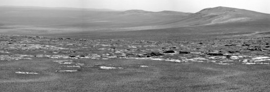
The science team for the rover Opportunity have released their first image taken from the rim of Endeavour Crater.
Since this picture looks south from Spirit Point less than a football field’s distance from the rim, it appears to look into the crater, the mountains on the right being the crater’s rim. What looks like a debris field running across the center of the image looks to me to be a combination of exposed patches of bedrock and boulders on the plateau above the rim. For the scientists, those boulders will be the prime research targets, as they are possibly ejecta produced at crater impact and could therefore be material thrown out from deep within the Martian crust.