Posting will be light today, as I am joining University of Arizona PhD student Sarah Trube and several other Arizona cavers on a cave trip to collect water samples in a southern Arizona cave. This is in connection with research Sarah is doing to analyze the chemistry of cave dripwater and how it leads to the formation of cave speleothems. Moreover, she is tracking water flow and attempting to link it to climate and weather variations over time.
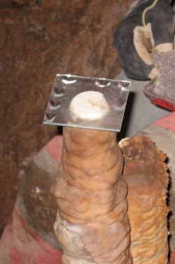
I noticed Sarah’s water collection equipment on my first Tucson-area cave trip back last January. In one case she had attached a tube to the bottom of a stalactite which fed the dripwater into a bottle. In another case she placed glass plates on top of stalagmites to allow the dripwater to drip onto the plate and then evaporate. Last month I joined her on one of her collection trips, where she gathered glass plates for later analysis in the lab. Though the plates had not been in cave more than a few months, you could easily see a thin layer of calcite deposit on their surface.
Below the fold is an image of Sarah gathering dripwater during an earlier trip.
» Read more

