
July 15, 2016 Zimmerman/Batchelor podcast
Embedded below the fold. Spent a lot of time talking about Curiosity’s future route up Mt. Sharp, including the possibility of getting a closer look at the balanced rock seen earlier.
» Read more
Embedded below the fold. Spent a lot of time talking about Curiosity’s future route up Mt. Sharp, including the possibility of getting a closer look at the balanced rock seen earlier.
» Read more
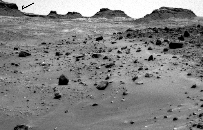
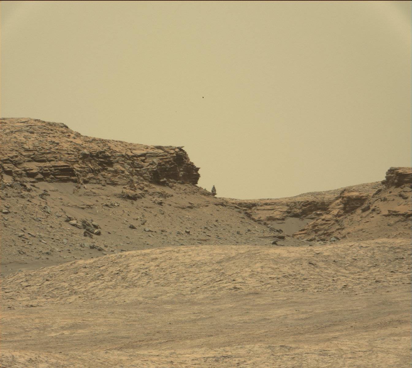
The image above is a panorama I have created from the raw images taken by Curiosity’s left navigation camera today, using this image for the left half and this image for the right half. They show the terrain in front of the rover, including the balanced rock on the horizon, indicated by the arrow.
I have no idea what route the science team plans, but looking at all of the images, as well as their desire to get a closer look at the rock, I suspect they will head up to the left on the smoother ground, aiming almost directly at the balanced rock. I also suspect that they will eventually veer right before getting to the rock, since the rover can’t go over the rough terrain in that area. Stay tuned to find out.
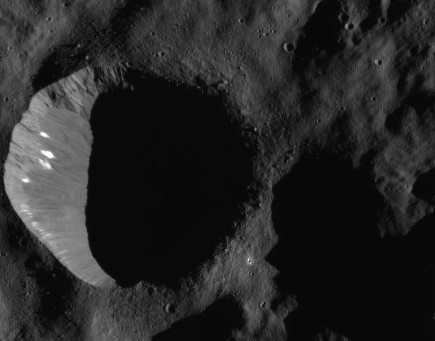
Cool image time! The most recently released Dawn image of Ceres, cropped on the right, included these bright streaks running down the side of an unnamed crater. They are especially intriguing because they so much resemble the seepage lines scientists have found on slopes on Mars. On Mars the lines appear to come and go on a seasonal basis, while on Ceres they appear to have been caused by a one-time event, after which not much has changed. In both cases, however, they appear to be caused by some liquid seepage that came from below the surface.
A little more than a week after it went into safe mode Curiosity today resumed full operations.
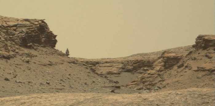
Cool image time! Prior to going into safe mode Curiosity’s mast camera took a series of images of its surroundings, as is routine as the rover travels. Among those images was the image above, though I have cropped it and reduced its resolution to show here. It reveals a balanced rock on the horizon. It also shows, as do the other survey images, how increasingly rough the terrain is becoming that Curiosity is traveling through.
The Curiosity science team has no intention of getting too close to this rough terrain, but they do hope to get better views of this rock as they continue the rover’s journey uphill.
For the first time in three years, Curiosity has entered safe mode.
On July 2, Mars rover Curiosity ceased science operations on the slopes of Mount Sharp after a fail safe was tripped, forcing the nuclear-powered robot into a low-power “safe mode.” According to a NASA Jet Propulsion Laboratory report, preliminary information communicated by Curiosity suggests an “unexpected mismatch between camera software and data-processing software in the main computer” may have been the culprit and the rover’s automated systems took over, preventing any permanent damage from being caused.
They are in communications with the rover, and expect a full recovery.
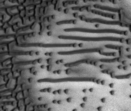
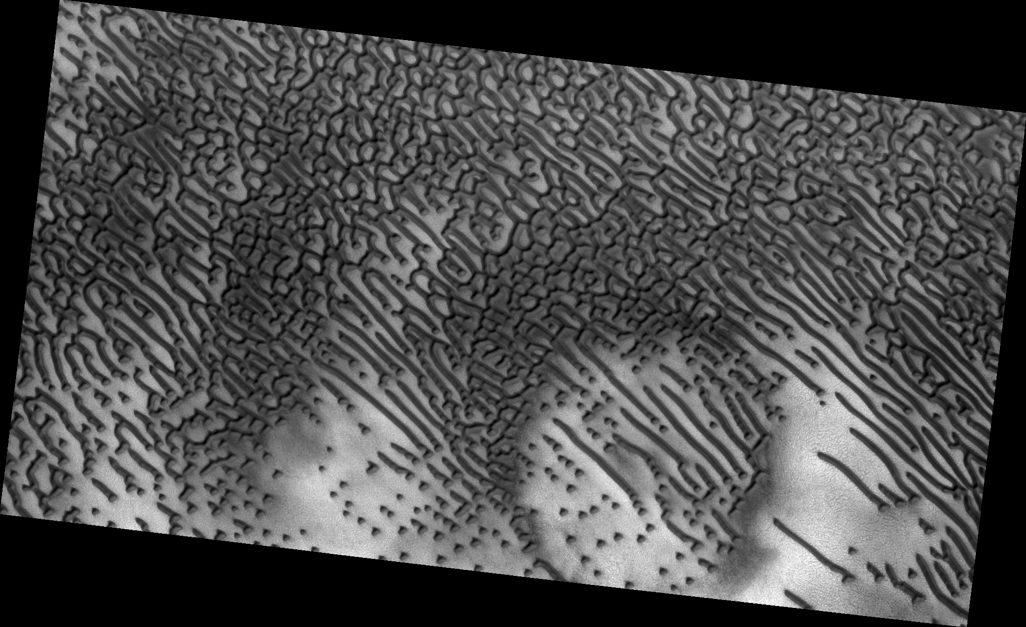
Cool image time! The image on the right, cropped and reduced in resolution to fit here, shows an area of inexplicable dark dunes located in Mars’ high northern latitudes. Located in a circular depression (whose outline can be seen across the top and left side of the image), geologists only partly understand the processes producing these dunes. As the noted on the release webpage:
However, a circular depression (probably an old and infilled impact crater) has limited the amount of sand available for dune formation and influenced local winds. As a result, the dunes here form distinct dots and dashes. The “dashes” are linear dunes formed by bi-directional winds, which are not traveling parallel to the dune. Instead, the combined effect of winds from two directions at right angles to the dunes, funnels material into a linear shape. The smaller “dots” (called “barchanoid dunes”) occur where there is some interruption to the process forming those linear dunes. This process is not well understood at present and is one motivation for HiRISE to image this area.
Be sure to look at the full image, as it covers a wider area and shows dunes that travel in all directions, forming mazelike patterns that no theory presently explains.
The uncertainty of science: Annual Reviews periodically publishes papers providing a detailed scientific review of the present state of knowledge in a variety of fields. They do this by collecting the papers in volumes focused on general areas of research, such as Astronomy and Astrophysics, Plant Biology, and even Sociology.
Today I received the announcement of the publication of the 44th volume of the Annual Review of Earth and Planetary Sciences, listing the volume’s table of contents. While there were many interesting papers on a variety of planetary subjects that interested me (“The climate of Titan,” “Impacts of Climate Change on the Collapse of Lowland Maya Civilization,” and “The Lakes and Seas of Titan”), one paper in particular, entitled “The climate of early Mars”, intrigued me enough after reading the abstract to download it and read it in its entirely. (As a science journalist I have free access to the full text of these papers. While the abstract is free to all, if you wish to read the full text you need to either buy it, or visit a university library that subscribes to each particular series.)
As a review I found the paper quite fascinating. It provided an excellent overview of our present understanding of Mars’s climate history, information that is especially useful to me in reporting on the results from the various Martian orbiters and rovers, as it gives me a wider context and allows me to better understand and analyze each press announcement. This in turn allows me to distinguish between a real discovery of some importance and a garbage press release that is really nothing more than a sales pitch for more funding.
The bottom line of this paper however is this: We know without doubt, based on a lot of geological evidence, that approximately 3 to 4 billion years ago liquid water existed on the Martian surface, leaving behind complex valley drainage networks similar to those created by flowing water on Earth. In addition, the data from the rovers has also found evidence, clays and other minerals, that could only have formed if water once flowed on the surface. What we don’t know is how that liquid water could have existed. The data so far does not provide any clear mechanism for warming the climate enough as well as producing a thick enough atmosphere to allow liquid water to flow. To quote the paper:
In summary, no single mechanism is currently accepted as the cause of anomalous warming events on early Mars.
The data also suggests that an ocean on Mars was unlikely, though not impossible. Instead, it appears that if any warming events occurred to produce liquid water, they were temporary and short-lived. What caused those warming events, however, remains a scientific mystery.
The paper also made clear once again the complexity of climate science, and how difficult it is to develop climate models that explain the geological evidence, not just on Mars, but on Earth as well. As the paper also noted, “Just like the climate of Earth today, the ancient climate of Mars was probably complex, with multiple factors contributing to the mean surface temperature.” And like the climate of Earth, many of those multiple factors remain uncertain and poorly understood. It will be many years before we really understand how Mars got to be the way it is.
Likely, to figure it out we will have to go there ourselves and poke around with our own hands.
In preparation for its October arrival in Mars orbit, the European ExoMars probe has successfully sent back its first images of the red planet.
The image is very fuzzy with a very low resolution, but that is expected considering the distance. What the image demonstrates is that ExoMars’ camera is working as expected.
After almost a year exploring Marathon Valley, an east-west cut through the western rim of Endeavour Crater, the Mars rover Opportunity is about to head out and south, following the outside of the crater’s rim.
For a rover that was only supposed to last 90 days, Opportunity has now traveled more than 26.5 miles in its 12 years of operation on the Martian surface.
After four years of southwest travel to skirt a large dune field at the base of Mount Sharp, Curiosity has finally turned due south to aim directly up the mountain.
“Now that we’ve skirted our way around the dunes and crossed the plateau, we’ve turned south to climb the mountain head-on,” said Curiosity Project Scientist Ashwin Vasavada, of NASA’s Jet Propulsion Laboratory, Pasadena, California. “Since landing, we’ve been aiming for this gap in the terrain and this left turn. It’s a great moment for the mission.”
The competition heats up: In an interview with the Washington Post this week, Elon Musk gave some more hints at his company’s future plans to send its Dragon capsules to Mars.
“Essentially what we’re saying is we’re establishing a cargo route to Mars,” [Musk] said. “It’s a regular cargo route. You can count on it. It’s going happen every 26 months. Like a train leaving the station. And if scientists around the world know that they can count on that, and it’s going to be inexpensive, relatively speaking compared to anything in the past, then they will plan accordingly and come up with a lot of great experiments.”
The key to Musk’s effort is that he plans on doing it. He isn’t sitting around waiting for others, or trying to convince others to join him in a partnership before proceeding. He is simply doing it, and is welcoming others to take advantage of the opportunity he is offering.
Data from the many Martian orbiters since 1997 have allowed scientists to roughly outline a seasonal pattern of dust storms on Mars.
Most Martian dust storms are localized, smaller than about 1,200 miles (about 2,000 kilometers) across and dissipating within a few days. Some become regional, affecting up to a third of the planet and persisting up to three weeks. A few encircle Mars, covering the southern hemisphere but not the whole planet. Twice since 1997, global dust storms have fully enshrouded Mars. The behavior of large regional dust storms in Martian years that include global dust storms is currently unclear, and years with a global storm were not included in the new analysis.
They have also found three types of regional dust storms, all of which appear to occur each Martian year.
New research using data from a variety of Mars orbiters suggests that large tsunamis previously smashed against the shores of the red planet, shaping the geography.
The group zeroed in on a region on Mars where the highlands known as Arabia Terra bump up against the lowlands of Chryse Planitia — a place where the waters of an ancient ocean might have lapped at the shoreline. Using imagery from several Mars-orbiting spacecraft, Rodriguez’s group identified two particular geological formations that they say formed during two different tsunamis. The first, older formation looks as if an enormous wave had rushed up onto the edge of the highlands, dropping boulders as big as 10 metres across. The water then drained back down into the ocean, leaving channels cut through the freshly deposited debris.
Then, millions of years passed. Temperatures dropped and glaciers crept across the landscape, scouring deep valleys. Finally, a second impact-generated tsunami came rushing again towards the shore. “But this time it is different,” Rodriguez says. Because the climate was so much colder, the tsunami moved over the landscape like an icy slurry. It froze before it had a chance to wash back into the ocean, leaving dense lobes of frozen debris on the ground.
They propose the waves were caused by large meteorite impacts. They also admit that there are large uncertainties in their theory and conclusions.
Two stories this week illustrate the difference between lobbying the government to get anything accomplished, and doing it yourself with the goal of making money from it from private customers.
In the first case SpaceX is planning to fly a Dragon capsule to Mars, using its Falcon Heavy rocket, and do it by 2018. It would not be manned, but would do the initial engineering testing for later manned missions, using larger interplanetary spacecraft. SpaceX is not asking the government to help pay for it. They are only making sure they have dotted all the legal “I”s required. The goal is to build spacecraft that can take anyone to Mars who is willing to pay for the flight.
In the second case Lockheed Martin is proposing a big government program to put six astronauts in orbit around Mars, in 2028. They haven’t really built anything yet to do this, they merely are lobbying the federal government to pay for it.
Which do you think is more likely to happen? Anyone who reads Behind the Black knows that I choose SpaceX. For 40 years I have seen many different variations of Lockheed Martin’s proposal, all of which came to nothing. They are powerpoint proposals, not real engineering, designed to wow Congress and NASA and get funding for the company. Nothing will ever be built, since the actual construction is so far into the future and so untested that it is impossible to predict what will really happen.
SpaceX however is planning a real mission, which is being designed to lay the groundwork for later more complex attempts. Rather than propose something big for far in the future, they are building something reasonable and doable now. Moreover, they aren’t lobbying the government, they are advertising their skills to the entire world, with the goal of convincing everyone to buy their very real product.
UPDATE: I should add a link here to Orbital ATK’s proposal in Congressional hearings on Monday to use their Cygnus capsule to build a cislunar space station by 2020. Like Lockheed Martin, they are lobbying Congress to build a mostly powerpoint concept. Why don’t they instead make an investment of their own money, like SpaceX, to send some Cygnus capsules to lunar space and demonstrate the concept, while also learning what needs to be done? I would have greater faith in the reality of their concept if they did that.
The Curiosity science team has released the weather data they have gathered during the rover’s two Martian years spent in Gale Crater.
The temperatures have ranged from a high just below freezing to lows around minus 120 degrees Fahrenheit.
New data of past volcanic activity on Mars suggest that the red planet was once covered by at least one extensive ice sheet.
There is a great deal of uncertainty in this conclusion, however. They have found one example with the right geology to suggest past ice sheets under which volcanoes erupted. Translating this into an extensive ice sheet requires many assumptions that might not prove true with further research.
After looking at their schedules the Russians and Europeans have agreed that they cannot meet the schedule to launch the second ExoMars mission by the next launch window in 2018, and have agreed to delay the mission until 2020.
This really isn’t a surprise, since Russia was a late replacement of the U.S. when the Obama administration backed out of the project suddenly. They need time to prepare.
Scientists now think that the dark streaks they see seasonally develop on Martian slopes are caused when frozen underground water brine is exposed to the atmosphere so that the water boils off, leaving the salt.
More here, including videos of their Earthbound experiments. On Earth, the boiling water caused avalanches and streaks, but because of the higher gravity they were not as long.
Good news: The Curiosity engineering team has found that the rough and fractured rocky terrain the rover has been recently traveling across on Naukluft Plateau has not significantly increased the wear & tear on the rover’s wheels.
The rover team closely monitors wear and tear on Curiosity’s six wheels. “We carefully inspect and trend the condition of the wheels,” said Steve Lee, Curiosity’s deputy project manager at NASA’s Jet Propulsion Laboratory, Pasadena, California. “Cracks and punctures have been gradually accumulating at the pace we anticipated, based on testing we performed at JPL. Given our longevity projections, I am confident these wheels will get us to the destinations on Mount Sharp that have been in our plans since before landing.”
Inspection of the wheels after crossing most of the Naukluft Plateau has indicated that, while the terrain presented challenges for navigation, driving across it did not accelerate damage to the wheels.