Sinkholes on Mars

Caver alert! Releases this week from both the Mars Express orbiter and the Mars Reconnaissance Orbiter show a variety of sinkholes and collapse features on Mars, which in turn suggest the possibility of underground passages.

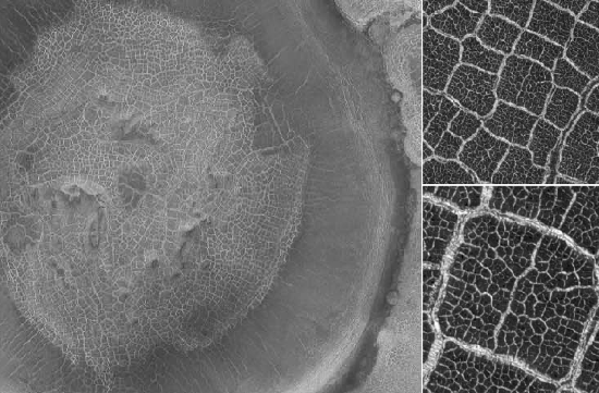
First, there is this picture from Mars Express, showing the area called Phoenicis Lacus (Latin for Phoenix Lake).

Phoenicis Lacus

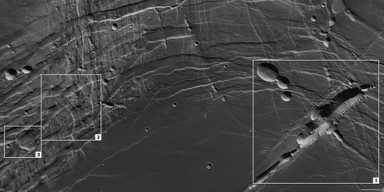
The large and long canyon in box 1 is actually a collapse feature, almost two miles deep and formed as this region was stretched, warped, and cracked by the powerful volcanic activity of the nearby giant volcanoes of the Tharsis plateau, including Olympus Mons, the solar system’s largest volcano. You can also see how this activity causes several sinkholes and craters in all three boxes to become elongated and distorted.

In places where the surface is deformed in this way on Earth, you often find tectonic caves, underground cracks produced as the ground is pulled apart. The large collapse feature suggests the possibility that there are voids below it.

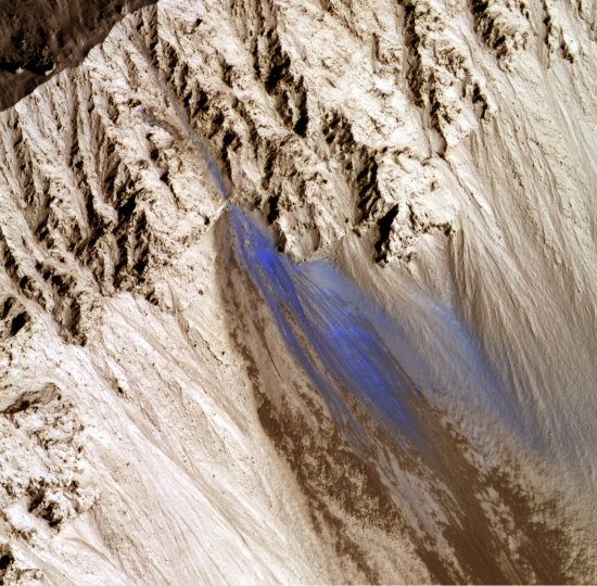
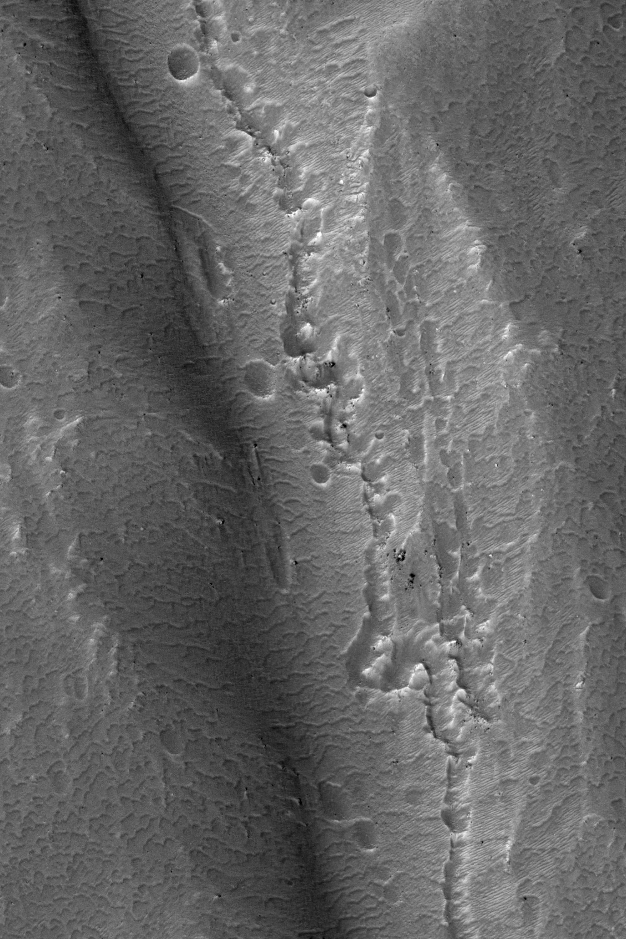
Then there is this subimage from this release of Mars Reconnaissance Orbiter, showing the central peak and southern slope of an old crater in the Terra Sirenum region of the Martian southern hemisphere.

central crater peak

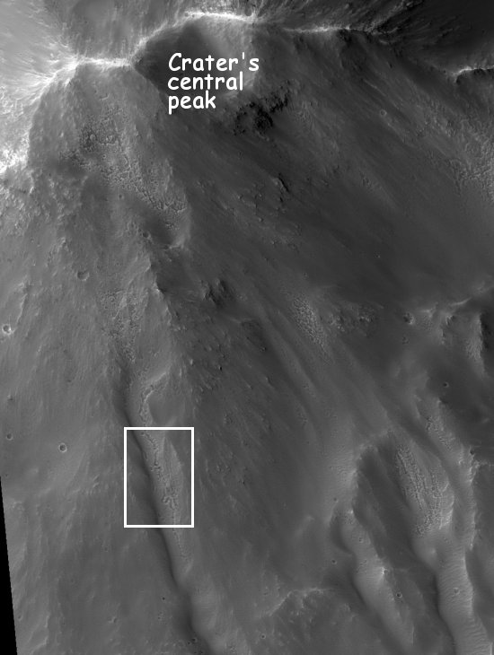
Down that south slope can be seen what look like fluvial-like flows. In the center of these flows as well as near the top of the peak are what appear to be a string of collapse features. Below is the close-up as indicated by the box above:

inset closeup of sinkholes

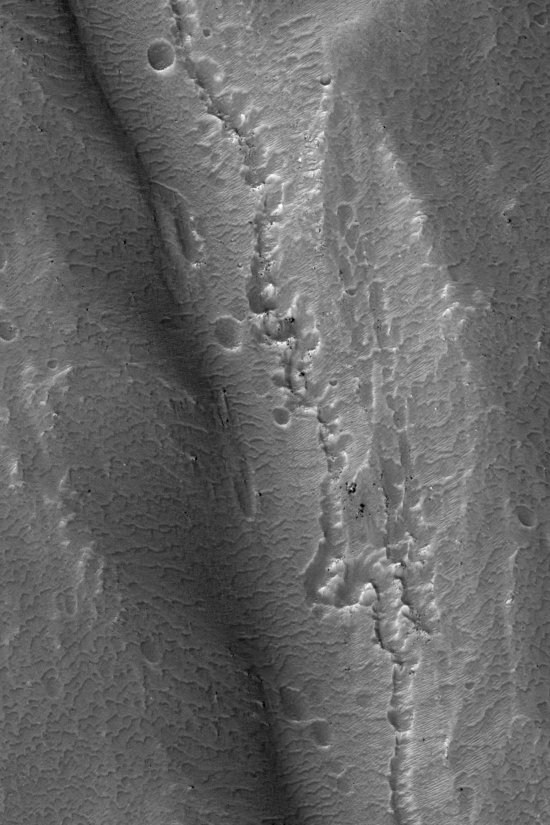
From the caption: “It is possible that these pits are evidence of subsurface piping or hydrothermal activity. Piping occurs when subsurface water flows through soil, takes some soil with it, and causes the overlying ground to collapse. These fluvial-like features and the connected pits may have formed during a late stage of crater formation when temperatures were suitable for liquid water.”

On Earth, this is one of the geological processes that forms sinkholes on the surface as well as caves underground. When cavers go out to look or dig for new caves, we often head for just this kind of string of sinkholes, as they are excellent evidence that an unentered cave lies hidden below, ripe for exploration.

2 comments

Dried up lake beds on Mars?

A paper published on Saturday in the Journal of Geophysical Research – Planets of the American Geophysical Union, scientists suggest that the polygonal shaped cracks seen in the crater floors on many Martian craters could be evidence of ancient lakes. The evidence also suggests that the lakes were formed by the impact that created the crater. The energy of the impact melted underground ice to form a temporary lake inside the crater, which eventually dries out, leaving behind the polygons. From the abstract:

We propose desiccation to be a dominant mechanism for the formation of Crater Floor Polygons without ruling out thermal contraction as a possible contributor in some cases. This implies that lakes or water-rich sediments occupied the craters in the past. Many such aqueous environments have no apparent external source of water, and thus, hydrothermal processes occurring shortly after the impact event may be viable explanations for the observed evidence.

Crater floor polygons on Mars

0 comments

Recent landslide on Mars

Mars Reconnaissance Orbiter has taken this image of what appears to be a recent landslide on Mars, located on the southeast wall of Zunil crater. When the landslide took place is not known, though the color suggests that it happened so recently that the debris has not yet been covered by wind-blown dust.

landslide on Mars

1 comment

A wish list of spectacular future planetary missions

Steve Squyres of Cornell University and the project scientist of the Mars rovers Spirit and Opportunity spoke today at an astrobiology symposium in Arlington, Virginia. He described several spectacular planetary missions that might be flown in the coming decade. All are being considered. None have yet been chosen or funded.

  • A mission to grab a sample from a comet and return it to Earth.

  • A mission to put a rover or lander on one of the poles of Mars to study the frozen layers of water under the icecap.

  • Mars sample return mission. This mission is so difficult and expensive that it probably would be broken down into three parts:
    • Two rovers on the surface to gather and cache sample material.

    • A lander/rover mission to grab the samples and bring them up to Mars orbit. “Putting into orbit a precious cargo the size of a coconut,” Squyres said.

    • A mission to grab the sample cargo in Martian orbit and return it to Earth.

  • An orbiter to study both Jupiter and its moon Europa.

  • An orbiter to Enceladus, the moon of Saturn, to study the water and organic chemistry in its mysterious plumes.

  • An orbiter to Titan, with balloon to probe the atmosphere as well as a “lake lander, a boat” to study Titan’s lakes.

  • A variety of landers and rovers to go to Venus. One of the more astonishing mission concepts would land, then take off again to visit different places on the surface.

Squyres is the co-chair of a committee of the National Science Foundation that is right now putting together a decadal survey for outlining unmanned planetary research for the next decade. This survey is expected to be released in March, which is when we will find out which of the above missions the planetary science community prefers.

1 comment

The wind-blown dunes of Mars

The HiRise Camera on Mars Reconnaissance Orbiter has released some wonderful new pictures, showing what are called barchan dunes on Mars.

Barchans are crescent-shaped, with the horns of the crescents pointing downwind. One barchan is visible in the upper part of the image, with the Southeast (lower right) horns longer than the other. This trend, along with the position of the steep face of the dune on the South side, indicates that the predominant winds which formed the dunes came from the North.

There are a lot more great images on the websites above.

Wind-blown dunes

0 comments
1 208 209 210 211 212