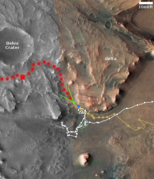
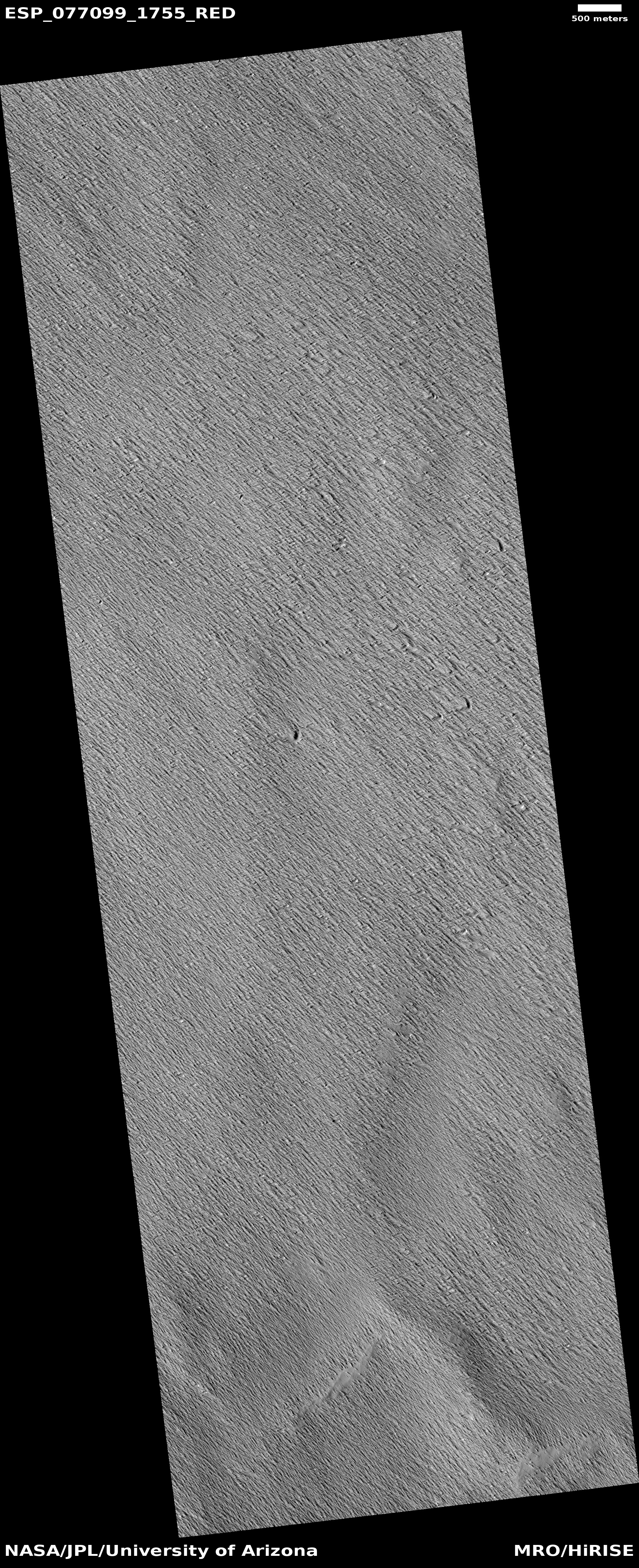
InSight’s power levels rise very slightly

InSight's power level through October 8, 2022

In a status report issued today, the science team for the InSight lander on Mars noted a slight increase in the amount of power produced daily by its solar panels. The graph to the right indicates that increase.

On October 8, 2022, InSight was generating an average of 300 watt-hours of energy per Martian day, or sol – an increase after a sharp decline last week from 430 watt-hours per sol to a low of 275 watt-hours per sol.

It appears that the atmosphere has begun to clear from the very large dust storm that occurred more than two thousand miles away. Despite that distance, the storm apparently reduced the available light above InSight significantly, and could take months to clear.

Icebergs of Martian lava

Icebergs of Martian lava
Click for full image.

Cool image time! The photo to the right, cropped, reduced, and enhanced to post here, was taken on July 24, 2022 by the high resolution camera on Mars Reconnaissance Orbiter (MRO). The scientists label this “platy-ridged lava” but to my eye this more resembles lava ice bergs trapped within a now frozen lava stream flowing I think from the northeast to the southwest.

My guess that the flow follows that direction is based on two bits of data. First, the shape of the lava ice flows suggests vaguely a flow to the southwest. The wiggling black ridges inside the streams suggest that these flows occurred in two parts, a stronger wide flow that narrowed as the lava on the edges hardened. When the edges solidified the interior flow scraped against it, forming the wiggling ridges.

Second, the location of this image, as shown on the overview map below, strongly suggests the lava streams flowed to the southwest.
» Read more

InSight shut down temporarily because of lack of power

InSight's power levels over recent time

Because a dust storm has caused a further decline in the power being generated by InSight’s solar panels, the science team has decided to put the lander into safe mode for the next two weeks in the hope that the air will then clear, allowing its power levels to rise.

The graph to the right shows that drop. From the press release:

By Monday, Oct. 3, the storm had grown large enough and was lofting so much dust that the thickness of the dusty haze in the Martian atmosphere had increased by nearly 40% around InSight. With less sunlight reaching the lander’s panels, its energy fell from 425 watt-hours per Martian day, or sol, to just 275 watt-hours per sol.

InSight’s seismometer has been operating for about 24 hours every other Martian day. But the drop in solar power does not leave enough energy to completely charge the batteries every sol. At the current rate of discharge, the lander would be able to operate only for several weeks. So to conserve energy, the mission will turn off InSight’s seismometer for the next two weeks.

The real problem however is the dust covering the solar panels. If that dust gets thicker due to this storm, the lander will not recover when they power it up in two weeks. It will still generate electricity at this low number, making future operations likely impossible.

Thick flow exiting dramatic canyon on Mars

Thick flow into Mamers Valles on Mars
Click for full image.

Cool image time! The photo to the right, cropped and reduced to post here, was taken on July 24, 2022 by the high resolution camera on Mars Reconnaissance Orbiter (MRO). It shows what the scientists label as a “viscous flow” that has apparently carved the wide curving canyon as it slowly flows into open country to the south.

I would estimate the height of that canyon wall to be around 3,000 feet, though this is a very rough guess. I also image a trail switchbacking up the nose of that canyon wall would make for a truly stupendous hiking experience.

The flow filling the canyon floor appears very glacial, which is not surprising as this canyon is at 37 degrees north latitude, in the mid-latitude band where many glacial features are found. The overview map below provides some more detailed context.
» Read more

Martian crater and mesa sculpted by ancient flow

Martian crater and mesa sculpted by ancient flow
Click for full image.

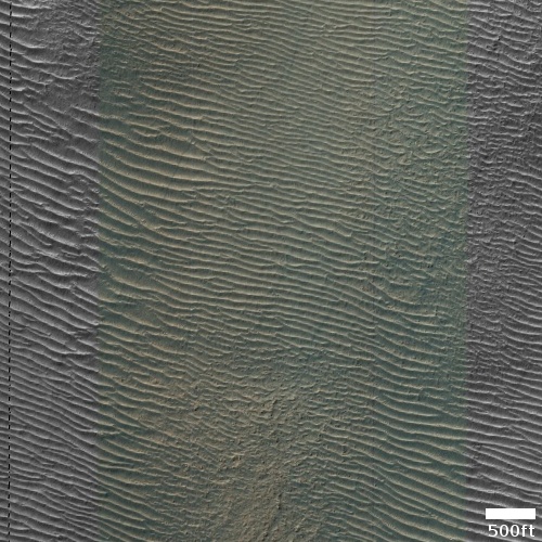
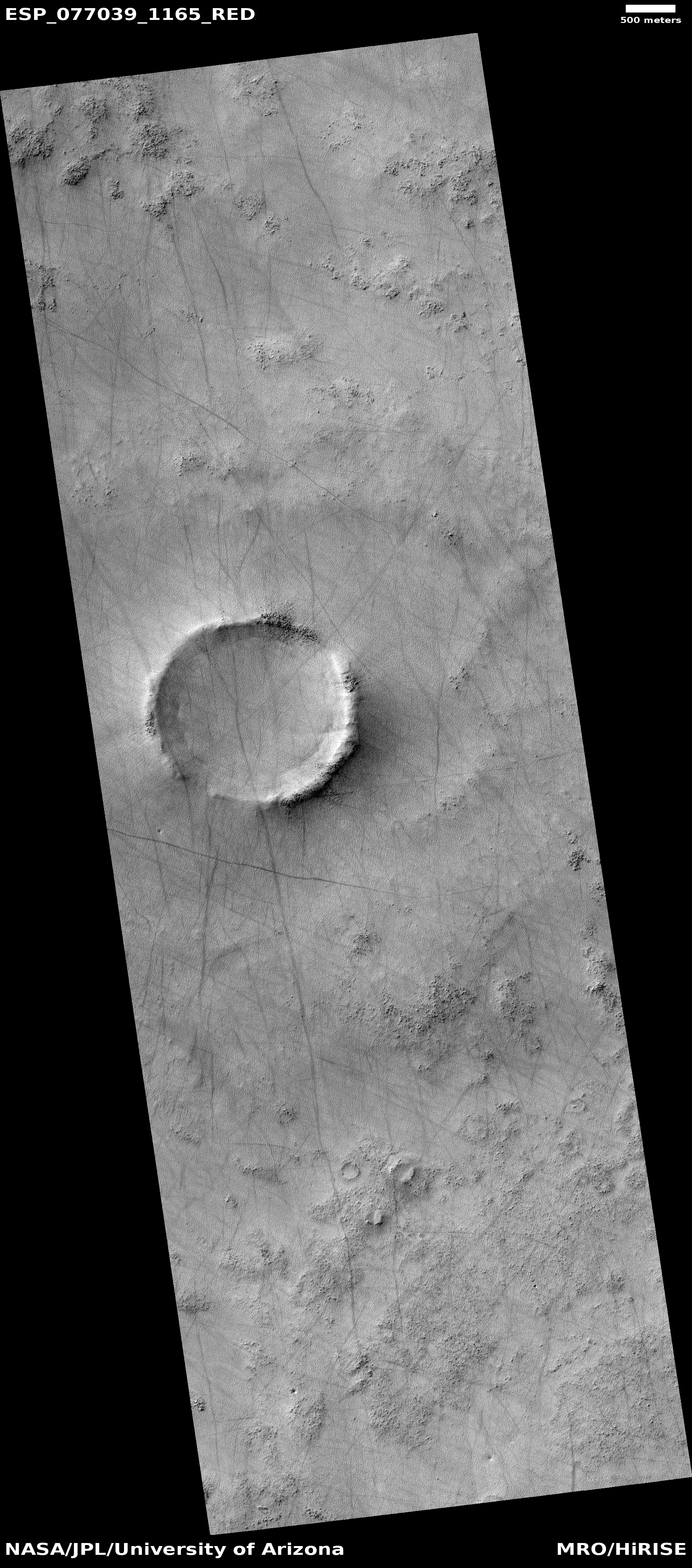
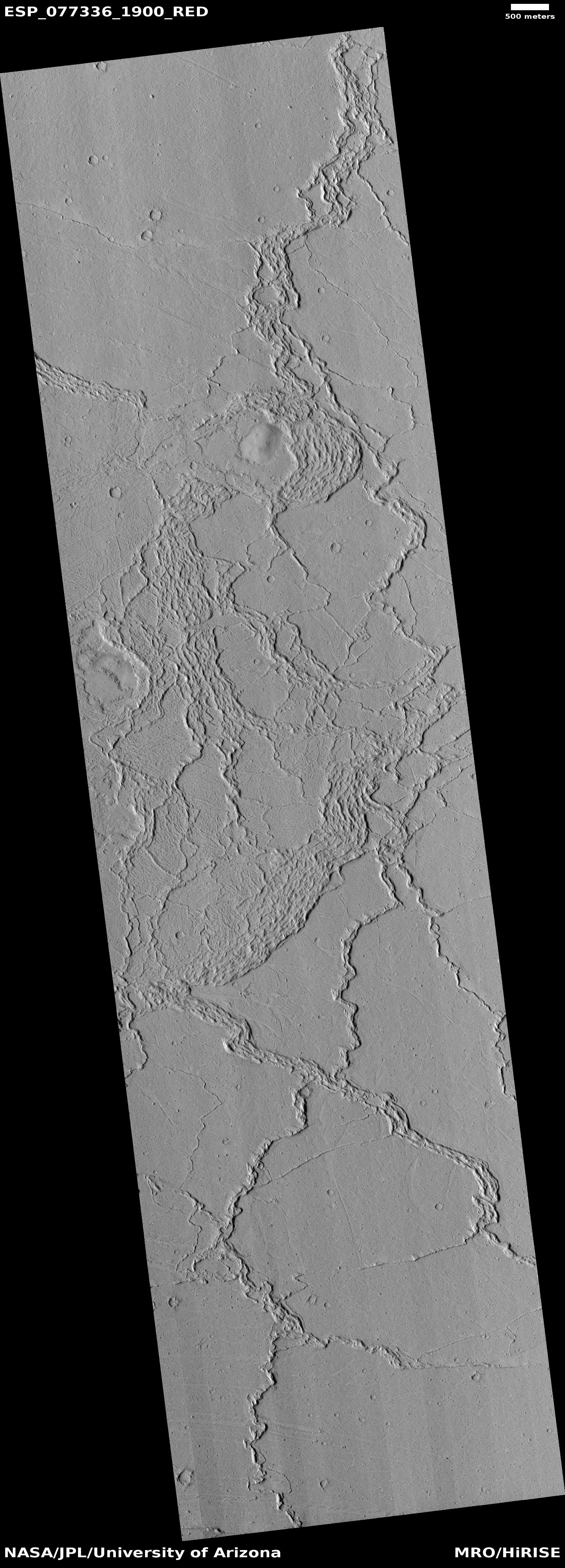
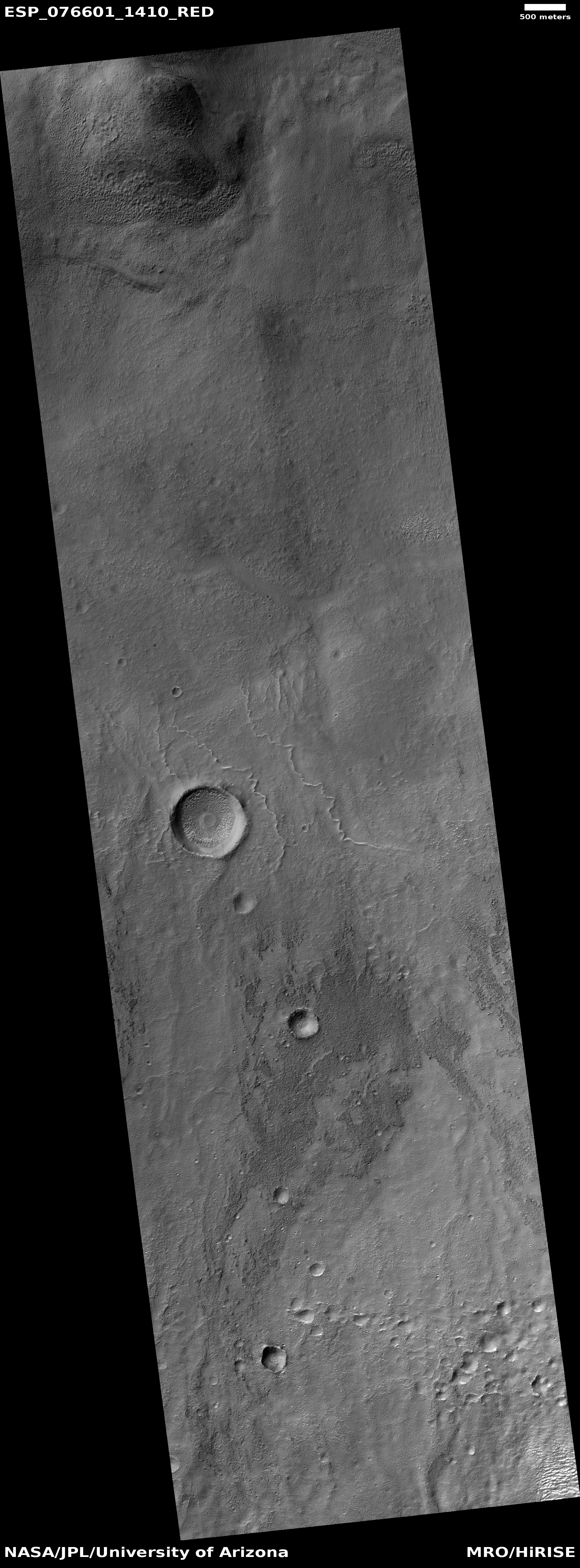
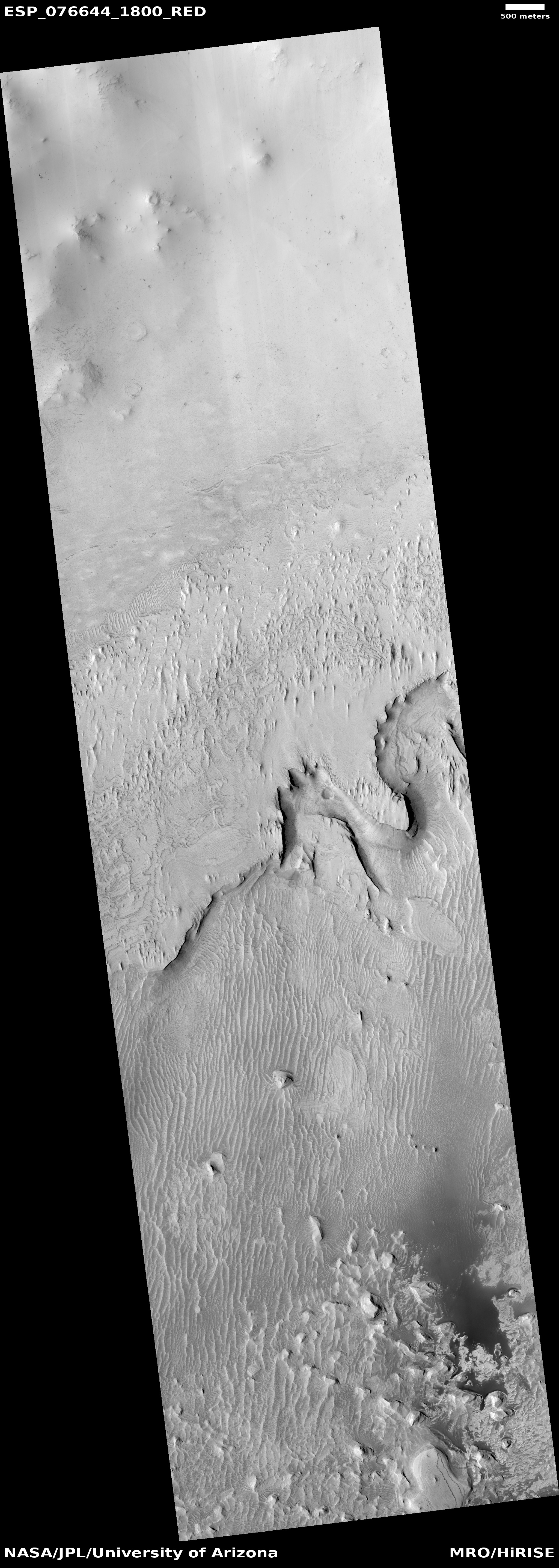
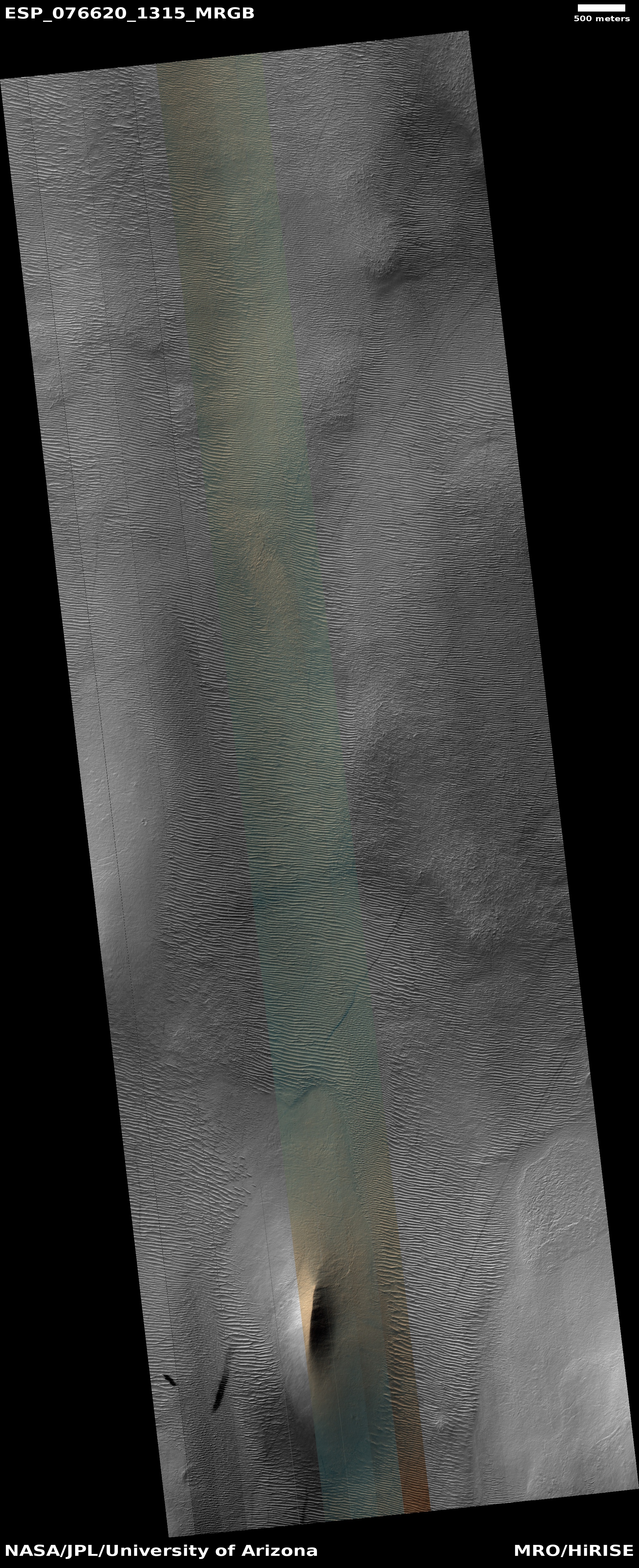
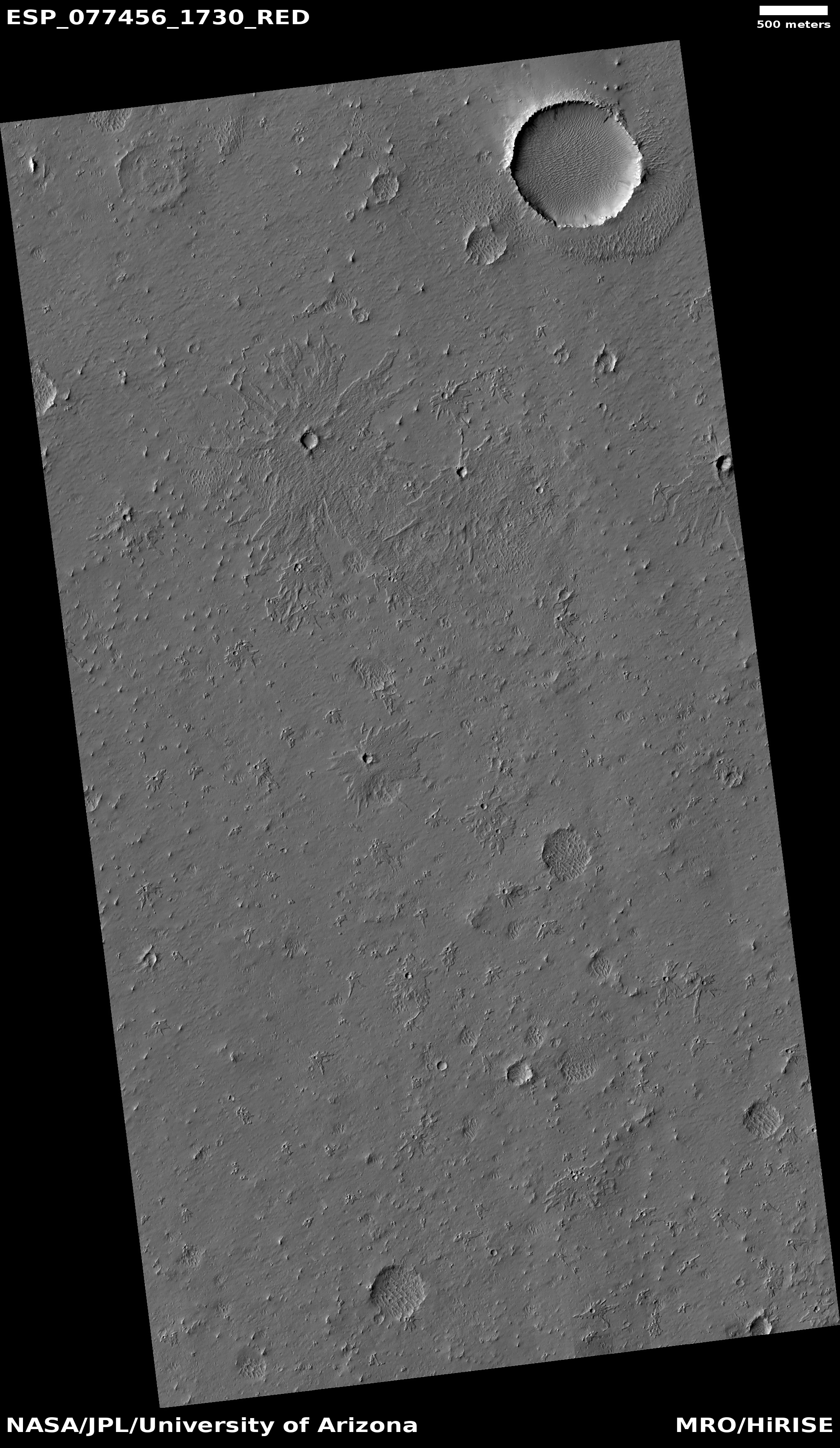
Cool image time! The picture to the right, rotated, cropped, and reduced to post here, was taken on June 15, 2022 by the high resolution camera on Mars Reconnaissance Orbiter (MRO). It shows a crater whose ejecta has been sculpted to the east into a teardrop-shaped mesa by some ancient flow, coming from the west.

The crater itself is located in one of several outflow canyons draining out from the volcanic Tharsis Bulge into the northern lowland plain of Chryse Planitia, the biggest of which is Valles Marineris. This particular canyon is one of the smaller and is dubbed Ravi Vallis.

The overview map below illustrates why many scientists think the flow that shaped this mesa came from a catastrophic flood of liquid water, billions of years ago.
» Read more

Another “What the heck?” formation on Mars

Another
Click for full image.

Cool image time! The photo to the right, cropped, reduced, and enhanced to post here, was taken on May 28, 2022 by the high resolution camera on Mars Reconnaissance Orbiter (MRO), and shows what the scientists label “unique terrain.”

I have increased the contrast to bring out the details. It appears that we have a flat plain of criss-crossing ridges that in large areas have somehow gotten flattened across their top. Imagine someone laying plaster on a wall and using a scraper tool to smooth the surface, but only partially. In this case on Mars, our imaginary worker only smoothed the surface a little, and only in some areas. To try to come up with a geological process however to explain this seems daunting.

And what created the criss-crossing ridges? The overview map provides only a little help in answering these questions.
» Read more

Tiny cobbles on Mars

Tiny cobbles on Mars

Our second cool image takes us from grand galaxies, one of the universe’s largest coherent objects, to tiny cobbles on Mars. The picture to the right, taken by one of Perseverance’s close-up cameras on September 29, 2022, covers an area less than an inch across, making the largest rounded pebbles in this image only a few millimeters in size.

The rover presently sits on the floor of Jezero Crater, at the base of the delta that flowed into that crater eons ago. The data suggests that delta was created by flowing water entering a lake that filled the crater.

Did flowing water create these cobbles? These pebbles all have the look of the rounded cobble one finds either in river beds, or in glacial moraines. In both cases, the flow of the water or ice rolls the rocks along until they become rounded.

India’s Mars orbiter mission ends after eight years

After eight years in orbit around Mars, India’s Mars orbiter mission, Mangalyaan, has run out of fuel for controlling its orientation, ending its mission.

The Rs 450 crore Mars Orbiter Mission was launched onboard PSLV-C25 on November five, 2013, and the MOM spacecraft was successfully inserted into Martian orbit on September 24, 2014 in its first attempt. “Right now, there is no fuel left. The satellite battery has drained,” sources in the Indian Space Research Organisation (ISRO) told PTI. “The link has been lost”.

There was, however, no official word from the country’s national space agency, headquartered here.

During its mission it produced more than a thousand images, though the mission’s primary objective was technological, proving that India itself could design, build, launch, and manage a planetary mission to another world. For India, Mangalyaan was thus an unqualified success.

Fabric debris spotted on Ingenuity during 33rd flight

Tattered fabric debris on Ingenuity's leg during flight
Click to see full movie of flight.

In reviewing the images from Ingenuity’s 33rd flight on September 24, 2022, engineers have spotted what looks like a tattered piece of fabric fluttering on the end of one of the helicopter’s legs, and then disappearing.

The image to the right, cropped, enhanced, and labeled to post here, comes from an animation created from all images taken during the flight.

A small piece of foreign object debris (FOD) was seen in footage from the Mars helicopter’s navigation camera (Navcam) for a portion of its 33rd flight. This FOD was not visible in Navcam footage from the previous flight (32). The FOD is seen in Flight 33 Navcam imagery from the earliest frames to approximately halfway through the video, when it fell from the leg and drifted back to the Mars surface.

The engineers do not yet know what this was, but it apparently caused no harm to the helicopter. It also is likely not from either Ingenuity or Perseverance, as both are functioning perfectly. Most likely it is a piece of the parachute used during landing and then ejected.

Ingenuity completed 33rd flight this past weekend

This notice is a bit late, but then, there really isn’t much to report. According to the Ingenuity flight log, engineers successfully completed the helicopter’s 33rd flight on September 24, 2022, flying about 364 feet for 55 seconds.

The plan had been to fly 365 feet for 55.6 seconds, so that matched their plan almost exactly. According to the interactive map that tracks the movement of both the rover Perseverance and the helicopter, this flight continued the helicopter’s movement almost due west, bringing it closer to the rover so as to facilitate communications.

The primary goal of Ingenuity’s engineering team at this time is to refine the accuracy of their software in order to better understand how to fly robots on Mars. This will help prepare the next helicopters for future missions.

More glaciers in Mars’ glacier country

Overview map

glacial layering in Clasia Vallis
Click for full image.

Cool image time! The photo to the right, rotated, cropped, and reduced to post here, was taken on June 18, 2022 by the high resolution camera on Mars Reconnaissance Orbiter (MRO). It shows what appear to be layered glacial features on the floor of what at first glance appears to be a crater.

It is not a crater however. The depression in the lower right of this image is the rim and floor of a 77-mile-long meandering canyon on Mars dubbed Clasia Vallis. The red cross in the overview map above marks its location, at 34 degrees north latitude. This channel drains downward from the southern cratered highlands into the 2,000-mile-long mid-latitude strip of mensae terrain that I dub glacier country because almost every hi-res image from this region shows glacial features.

Below is a wider view of Clasia Vallis, taken by the context camera on MRO on March 19, 2014.
» Read more

Radar data from Zhurong finds no ice to a depth of 260 feet

Zhurong's ground-penetrating radar data

Overview map

Chinese scientists today finally published their results from the ground-penetrating radar instrument on their Mars rover Zhurong, revealing that to a depth of 260 feet (80 meters), it detected no clear signal of water ice.

Figure 2 of their paper, posted above, summarizes their results. It shows the radar profile to 328 feet (100 meters) depth along Zhurong’s route, as shown in the map to the right, with the last bit of its recent travels ending somewhere in the blue circle. From the paper:

Our low-frequency radar imaging profile shows radar signals within the depth range of 0–80 m (Fig. 2a), precluding the existence of a water-rich layer within this depth range as the existence of water would strongly attenuate the radar signals and diminish the visibility of deeper reflections. The estimated low (less than 9) dielectric permittivity (Fig. 2c) further supports the absence of a water-rich layer as water-bearing materials typically have high (greater than 15) dielectric permittivity.

We further tested this assessment with thermal considerations by conducting a heat conduction simulation based on available thermal parameters estimated from previous studies (Methods). Our thermal simulation results … show that the Zhurong landing area has an annual average temperature of around 220K in the RoPeR detection depth range, which is much lower than the freezing point of pure water (273K), and also lower than the eutectic temperatures of typical sulfate and carbonate brines, but slightly above those of perchlorate brine systems. This observation suggests that the shallow subsurface of the Zhurong landing area could not stably contain liquid water nor sulfate or carbonate brines, consistent with the radar imaging result.

The data suggests that below the surface topsoil layer, the regolith, there are two distinct layers of material that the scientists interpret as possible evidence of past catastrophic floods. That conclusion however is very very uncertain. The main take-away is that in the northern lowland plains of Utopia Planitia at 25 degrees north latitude, where Zhurong landed, Mars is definitely a dry desert, with no water close to the surface.

This data also suggests that if you establish a colony anywhere in Mars’ dry equatorial regions within 30 degrees latitude of the equator, you will likely have to travel north or south a considerable distance to get to easily accessible ice. The global map of Mars below shows the regions where ice is most evident, north and south of 30 degrees latitude.
» Read more

Zig-zag ridges on Mars

Zig-zag ridges on Mars
Click for full image.

Cool image time! The photo to the right, cropped and reduced to post here, was taken on April 9, 2022v by the high resolution camera on Mars Reconnaissance Orbiter (MRO). It shows a series of parallel zig-zag ridges in a flat, knobby terrain.

I don’t presume to explain this at all. According to one research paper,

This interplana region consists of extensive networks of ridges—the eponymous Aeolis Dorsa—and is interpreted as having formed by topographic inversion of fluvial and alluvial deposits.

Why these ridges zig-zag however does not seem to fit into either a fluvial or alluvial explanation, both of which involve the flow of water. The quote implies these could be inverted stream channels (where the compacted streambed becomes a ridge when the surrounding terrain erodes away), but once again, the distinct zig-zag pattern seems wrong. Rivers meander, but they don’t generally turn right and left so sharply. And why should we see parallel zig-zags? This doesn’t seem to fit with a river channel origin.

The particular location, as shown on the overview map below, is close to the dry Martian equator, on the edge of Medusae Fossae Formation, the largest field of volcanic ash dust on Mars.
» Read more

Above ground and underground Martian drainages

Overview map

Cool image time! Today we are going to zoom into our cool image. The overview map to the right provides us the context. Our target is the small white rectangle inside the small box just below the north rim of 185-mile-wide Newton Crater, located 200 to 800 miles from the southwest edge of the lava plains dubbed Daedalia Planum that flowed down from Mars’s biggest volcanoes.

Newton Crater has a number of interesting features. Only two weeks ago I featured 4-mile-wide Avire Crater in Newton’s western quadrant, long known to have many gullies on its interior slopes as well as glacier features on its floor. Scientists have been monitoring those gullies now for more than a decade to see if they change seasonally, in a attempt to figure out their cause.

Today’s cool image looks at the very intriguing meandering canyons that appear to flow south from Newton’s north rim.
» Read more

Martian layers everywhere!

Layers in Argyre Basin
Click for full image.

Cool image time! The photo to the left, rotated, cropped, and reduced to post here, was taken on June 1, 2022 by the high resolution camera on Mars Reconnaissance Orbiter (MRO). It shows the rim edge to a fifteen-mile-wide canyon, with many apparent layers exposed on the high plateau.

The layers are intriguing in that they suggest several things. First, they give us a glimpse into the top and youngest layers that make up the interior canyon wall. Second, they tell us that erosion has removed much of those top and youngest layers, resulting in the mesas on that plateau.

Finally, the gullies flowing down into the canyon indicate further erosion processes, eating away at the canyon wall over time.

The location of this canyon is also intriguing.
» Read more

Another model attempts to show how liquid water could have once existed on Mars

The uncertainty of science: Scientists today published a new model that attempts to show how it was possible in the distant past for liquid water to have existed on the surface of Mars.

New research published in Earth and Planetary Science Letters suggests that Mars was born wet, with a dense atmosphere allowing warm-to-hot oceans for millions of years. To reach this conclusion, researchers developed the first model of the evolution of the Martian atmosphere that links the high temperatures associated with Mars’s formation in a molten state through to the formation of the first oceans and atmosphere. This model shows that — as on the modern Earth — water vapor in the Martian atmosphere was concentrated in the lower atmosphere and that the upper atmosphere of Mars was “dry” because the water vapor would condense out as clouds at lower levels in the atmosphere. Molecular hydrogen (H2), by contrast, did not condense and was transported to the upper atmosphere of Mars, where it was lost to space. This conclusion – that water vapor condensed and was retained on early Mars whereas molecular hydrogen did not condense and escaped – allows the model to be linked directly to measurements made by spacecraft, specifically, the Mars Science Laboratory rover Curiosity.

As a model, this theory proves nothing, though it is very intriguing. The scientists propose that the heat from the planet’s interior replaces the known lack of energy that came from the Sun in Mars’ far past. While this could work, what makes it very uncertain is that its surface data is based on a single measurement from Curiosity, hardly a deep and convincing baseline.

Ingenuity completes 32nd flight

According to a tweet from JPL, Ingenuity successfully completed its 32nd flight on Mars on September 18, 2022.

The 55.3-second flight covered 93.74m at a max speed of 4.75 meters per second.

That is about 308 feet distance, comparable to the helicopter’s previous flight. Though it probably continued to the west, as with that last flight, JPL’s tweet did not provide any directional information.

This second short hop in a row however suggests that the team’s focus has definitely shifted from scouting for Perseverance to practicing precision landings, thus gathering data to help build the future Martian helicopter that will be used to pick up Perseverance’s core samples some time in the future.

Want to do a virtual hike in Jezero Crater on Mars? You can!

Using data from Mars orbiters, Perseverance, and Ingenuity, scientists have now created a virtual hiking map of Jezero Crater, allowing anyone to explore in detail the same places that the rover and helicopter have visited.

You can view the map here. From the press release:

The map allows virtual hikers to zoom in and out, and pan rapidly across scenes, so that they can explore the landscape from large scales down to centimetre-detail. Some of the 360° panoramas integrated with the waypoints have been synthetically rendered from orbital image data. Others are real panoramas stitched together from a multitude of single images taken by the Mastcam-Z camera instrument onboard the Mars 2020 Rover Perseverance, which have been provided by the University of Arizona. The sounds have been recorded by the SuperCam instrument on that same rover mission.

I’ve played with the map only a little, but find it quite amazing and useful, especially because it seems to work well on my relatively ordinary desktop Linux computer.

InSight’s power level holding steady

InSight's on-going power levels

The Energizer bunny of Mars, the InSight lander, continues to hold on. The engineering team tonight issued another status report, as shown in the graph to the right. For the past week the lander continued to produce 420 watt-hours per day, even though the tau level of dust in the atmosphere increased from 0.8 to 0.85.

The tau level of dust outside of the winter dust season is normally between 0.6 and 0.7. Even though Mars is moving out of winter, that level has increased slightly above InSight. And yet, even with a higher dust content and thus less sunlight, the lander’s dust-covered solar panels are generating power, at a very slightly higher level.

The InSight team had expected the lander to die in early September, at the latest. Instead, it keeps running, thus allowing it to detect on September 5th an impact created by a cluster of three asteroids, the first time scientists have ever pinpointed exactly when such a new impact occurred on Mars.

For the lander to survive for even longer, all it needs is one gust of wind across the solar panels to clean them off. The science team had expected this to happen periodically, based on past experience with the Spirit and Opportunity rovers. Unfortunately for InSight, it has not yet happened even once since it arrived on Mars in 2018. Nonetheless, it only has to happen once to save the lander.

Stay tuned. All is not yet lost.

The strange scattered rocks of Gediz Vallis on Mars

The strange rocks of Gediz Vallis
Click for full image.

Cool image time! The photo to the right, reduced to post here, was taken on August 20, 2022 by Curiosity’s high resolution camera. It shows some of the scattered and very delicate rocks that it is finding on the floor of Gediz Vallis, the valley the rover had been striving for since landing more than a decade ago and finally entered in mid-August.

Because of Mars weak gravity, about 39% of Earth’s, and very thin atmosphere, about 1% of Earth’s, it is possible for surface rocks to erode into such delicate shapes. The shapes appear to be further encouraged by the many layers that exist in Mars, with each layer having different characteristics. In the case of the hanging flakes to the right, these layers were more resistant to erosion and thus remains intact while material above and below was slowly blown away.

InSight’s seismometer detects its first new impact on Mars

Martian impact discovered by InSight
Click for full image.

Using data from InSight’s seismometer that suggested a new impact had occurred at a specific location on September 5, 2022 on Mars, scientists used the high resolution camera on Mars Reconnaissance Orbiter (MRO) to search and find that impact.

The photo to the right, reduced to post here, is that MRO photo.

The initial impact itself created a small marsquake that was detected by InSight’s seismometer. The instrument recorded seismological data that showed the moment the meteoroid entered Mars’ atmosphere, its explosion into pieces in the atmosphere, and finally, the impact that created a series of at least three craters in the surface.

MRO then flew over the approximate site where the impact was “felt” to look for darkened patches of ground using its Context Camera. After finding this location, HiRISE captured the scene in color. The ground is not actually blue; this enhanced-color image highlights certain hues in the scene to make details more visible to the human eye – in this case, dust and soil disturbed by the impact.

This was thus the first new Martian impact detected based on its actual occurrence, rather than simply finding a change between two photos taken at different times. The latter only tells you a time period when the impact occurred. InSight’s detection here marks the impact’s exact moment.

Nor is this the only such discovery. It appears that InSight detected at least two other impacts (here and here), that only subsequently were linked to MRO impacts. In those cases, the new impact had already been found by MRO, and only afterward were scientists able to identify its seismic vibration in InSight data, thus pinpointing the exact date it took place.

Webb takes its first infrared image of Mars

Webb's first infrared image of Mars
Click for full image.

Astronomers have now released the the James Webb Space Telescope’s first infrared image of Mars, taken on September 5, 2022.

The image to the right, cropped and reduced to post here, shows some of the data obtained. Because Mars is so close, it is actually too bright for Webb’s instruments. To get any data, the exposures were very very short, and still the brightest areas — as indicated by large areas of yellow — are overexposed. The cause of the different brightness of Hellas Basin, however, is not simply because the basin — the deepest point on Mars — is cooler.

As light emitted by the planet passes through Mars’ atmosphere, some gets absorbed by carbon dioxide (CO2) molecules. The Hellas Basin – which is the largest well-preserved impact structure on Mars, spanning more than 1,200 miles (2,000 kilometers) – appears darker than the surroundings because of this effect. “This is actually not a thermal effect at Hellas,” explained the principal investigator, Geronimo Villanueva of NASA’s Goddard Space Flight Center, who designed these Webb observations. “The Hellas Basin is a lower altitude, and thus experiences higher air pressure. That higher pressure leads to a suppression of the thermal emission at this particular wavelength range [4.1-4.4 microns] due to an effect called pressure broadening. It will be very interesting to tease apart these competing effects in these data.”

The NASA press release says the scientists are preparing a paper analyzing the spectral data and what it revealed about “dust, icy clouds, what kind of rocks are on the planet’s surface, and the composition of the atmosphere,” I suspect however that Webb’s capabilities for studying Mars are much more limited than implied, and that it will over time take much fewer images of the red planet, compared to Hubble.

Deep inside the youngest flood lava event on Mars

Deep inside the youngest flood lava event on Mars
Click for full image.

Cool image time! Today we return to the Athabasca Valles flood lava event, believed to be the youngest major lava event on Mars that I highlighted in a cool image last week.

Then, I showed two meandering lava flows near the edge of this Great Britain-sized flood lava plain, produced 600 million years ago in only a matter of weeks. Today, we take a look deep within the lava plain. The photo to the right, rotated, cropped, and reduced to post here, was taken on May 6, 2022 by the high resolution camera on Mars Reconnaissance Orbiter (MRO). It shows what the scientists label “a lava-crater interaction.”

In plain English, we are looking at a crater that has been inundated by the flood lava, filling it.
» Read more

September 15, 2022 Quick space links

Courtesy of BtB’s stringer Jay, who trolls Twitter so I don’t have to.

The shattered cliffs of Mount Sharp

A broken cliff on Mars

Cool image time! The picture above was taken on August 11, 2022 by the left navigation camera on the Mars rover Curiosity. It shows a great example of the strange manner in which the bedrock in the layered cliffs on Mount Sharp appear to break apart.

I am not certain exactly where this feature is, or its exact scale, but based on the date and where Curiosity was located when the photo was taken, it likely is a small section from one of two hills, Deepdale and Bolivar, that Curiosity passed between in mid-August. It is likely somewhere in the panorama included in my August 11th post, but I have not yet been able to locate it.

Nonetheless, the breakage here is typical of these cliff faces. The structural strength of these layered hills is not very high, so at some point one section can break away from another as the hill sags downward to the left. What makes the cracks here more intriguing is that something caused the higher sections surrounding the main block to widen. On Earth we would assume that this widening was caused by rainwater pouring in from the top. On Mars, that explanation doesn’t hold water.

Wind? Seasonal thermal changes? Neither explains the change in the width of the cracks along their length. Maybe the wider cracks indicate an increased sagging of the hill to the left. The layers below this broken block have simply not slid to the left as much.

InSight’s power levels rise again

InSight's power levels through September 10th

Based on another status update issued today by the InSight science team, the electricity generated by the Mars lander’s dust-covered solar panels increased again slightly in the past week, going from 410 watt-hours per day to 420 watt-hours per day.

The graph to the right shows the trends since May. The science team had expected the power levels to steadily drop throughout the summer so that by early September the lander would die.

Instead, the power levels remained steady throughout the summer, and have in the past two weeks actually risen slightly, thus extending InSight’s life.

If at any moment a strong gust of wind or dust devil sweeps over InSight, the panels could be blown clear and it would gain a rebirth. The longer it manages to survive, the greater the chance that this might happen.

InSight’s power level goes up!

InSight's power levels as of September 5, 2022

The most recent status update on the Mars lander InSight, released today, shows a slight rise in the amount of power generated by its dust-covered solar panels.

As shown on the graph to the right, on August 27, 2022 the power level was 400 watt-hours generated per Martian day. On September, 5, 2022, the power level was 410 watt-hours per Martian day, the first power increase since late July. At the same time, the dust in the atmosphere continued to clear, going from a tau level of .88 to 0.8. Outside of the winter dust season tau is usually between 0.6 and 0.7.

The slight power increase continues to suggest that the lander’s death might be delayed. At 400 watt-hours per day, it has been able to run its seismometer since the beginning of July. With this slight increase, the chance increases that InSight will finally get that one gust of wind or dust devil that will blow the dust off its solar panels and allow it to recover some power and operate for longer.

Crazy badlands in the equatorial region of Mars

Badlands in the equatorial regions of Mars
Click for full image.

Cool image time! The photo to the right, rotated and cropped to post here, was taken on June 17, 2022 by the high resolution camera on Mars Reconnaissance Orbiter (MRO). The section highlighted is at full resolution, in order to make clear the absolutely crazy and complex terrain seen in the full image.

This terrain is not glacial, as the location is only about 1 degree south of the Martian equator. There might have been surface or near surface ice here once in the past, but there is none now.

Could we be looking at some form of lava flow? This is possible, because a close look at the context map at the image link suggests this region has been partly covered by some material, obscuring some craters to the east and west. However, there is no visible evidence anywhere in this region of a volcanic vent or caldera. If this covering material was volcanic it is very unclear where it came from.

The overview map below does not really provide any answers, but at least gives the context.
» Read more

A “what the heck?!” mesa in the southern polar regions of Mars

A
Click for full image.

Cool image time! The photo to the right, rotated, cropped, and reduced to post here, was taken on July 28, 2022 by the high resolution camera on Mars Reconnaissance Orbiter (MRO). It shows what the scientists label a “Circular and Banded Landform.”

I put this mesa into a geological category I dub “What the heck?!” We are clearly looking at a mesa, probably no more than 200 feet high, if that. What makes it baffling are the parallel bands that not only cut across the mesa but extend in the same direction for many miles in all directions. Though at first glance these bands appear to be dunes, their rocky eroded look along the mesa’s northwest rim suggests instead the bands are the top edge of many vertically oriented parallel layers, which at this mesa’s flanks are eroding alternatively at different rates.

The overview map below shows us where this mesa is located, relative to the south pole.
» Read more

Ingenuity completes 31st flight

Perseverance's location on September 2, 2022
Click for interactive map

Though no details have yet been released, the engineering team for the Mars helicopter Ingenuity has posted the numbers for the helicopter’s 31st flight, which took place yesterday.

Ingenuity flew 318 feet to a height of 33 feet for 56 seconds. The maximum ground speed was 10.6 mph. The white dot on the map to the right indicates the approximate landing spot. The blue dot Perseverance’s location as of September 3rd.

The flight plan had been to fly 319 feet, so Ingenuity landed one foot short of that plan.

That difference does not indicate any problems. However, one of the present goals of the engineering team is to improve their landing accuracy in order to provide data for the future sample return helicopter that is now in development to come and get Perseverance’s sample cores. That future helicopter will need to be able to land very precisely, and they are using Ingenuity to refine the Martian flight software.

1 20 21 22 23 24 80