
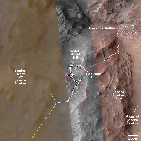
Computer model: A thin ice cap can preserve liquid water on Mars
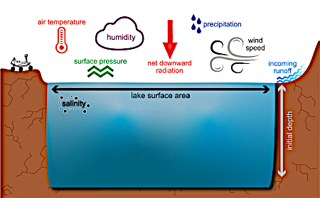
Figure 1 of the paper, showing the parameters
used in the computer model
Using a computer model, scientists have found that a thin cap of ice can act to allow liquid water to exist in lakes on Mars, for extended periods of time.
You can read their paper here. From the abstract:
Working at a localized scale, we combine climate input from the Mars Weather Research & Forecasting general circulation model with geologic constraints from Curiosity rover observations to identify potential climatic conditions required to maintain a seasonally ice-free lake. Our results show that an initially small lake system (10 m deep) with ∼50 mm monthly water input and seasonal ice cover would retain seasonal liquid water for over 100 years, demonstrating conditions close to long-term lake survivability.
From the press release:
In some simulations, the lakes completely froze during colder seasons, whereas in others, the lakes remained liquid and were covered by a thin layer of ice instead of freezing solid. This thin ice acted as an insulating lid, significantly reducing water loss while still allowing sunlight to warm the lake ice during warmer months. As a result of this seasonal cycling, some simulated lakes barely changed in depth over decades, suggesting that they could be stable for longer durations even with average air temperatures below freezing for much of the time.
Because this research is based on computer modeling, it carries great uncertainties. At the same time, it seems to explain the puzzling nature of Martian geology, which has repeatedly suggested the existence of liquid water in the past on a planet that has always been too cold with too thin an atmosphere for liquid water to exist. Data has also suggested that pockets of liquid water might have existed at the base of glaciers. This research aligns with that data.


