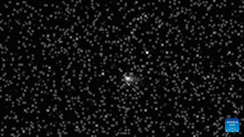
Scour pits of volcanic Martian ash

Scour pits in volcanic ash
Click for original image.

Cool image time! The picture to the right, cropped, reduced, and sharpened to post here, was taken on June 16, 2023 by the high resolution camera on Mars Reconnaissance Orbiter (MRO). The science team describes this as “clusters of scour pits,” which means the pits here were formed by the prevailing winds, which according to a global analysis of dunes on Mars, is probably blowing from the west to the east at this location.

This image only covers a small section of these scour pits. The full field extends about 20 by 18 miles across, and appears to be the southeastern flank of a mile-high dome. The scour marks could therefore also be evidence of some sagging of this material downhill along that flank.

It is also possible that the flow of the prevailing winds across this southeastern downhill slope is causing the pit formation. Unlike this flank, the rest of this dome is relatively smooth.
» Read more

Ingenuity completes 64th flight on Mars

Overview map
Click for interactive map.

Ingenuity's view just before landing
Click for original image.

In a pattern that is beginning to be almost routine, on October 27, 2023 the Mars helicopter Ingenuity completed its 64th flight on Mars, flying 1,348 feet at a speed of 13 mph for 139 seconds at an altitude of 39 feet.

As with most of its recent flights, the distance and time was slightly longer than the flight plan, likely because the helicopter took extra time finding a good landing spot.

On the overview map above, the green line marks the flight path, and the green dot the helicopter’s present position. The blue dot marks Perseverance’s present position. The yellow lines indicate the area covered by the color image to the right, cropped, reduced, and enhanced to post here. This image was taken by Ingenuity just a few seconds before landing, and looks across the floor of Neretva Vallis, where Perseverance will soon be traveling.

A new global map of the near-surface ice on Mars

Global map of near-surface ice on Mars
Click for interactive map.

A project begun in 2019 to use all the presently available orbital data to compile a global map of the near-surface ice on Mars has now been released that global map, shown by the graphic above, taken from Figure 16.7 from the project’s science paper.

The various areas in blue show the evidence of ice down to about 5 meters, or about 15 feet, with darker blue areas indicated ice at greater depth. The study focused on latitudes below 60 degrees latitude, while also blocking out areas above one kilometer in elevation (as indicated in black on the map above). As the paper noted,
» Read more

The icy terrain near one of Starship’s prime candidate landing spots on Mars

The icy terrain near Starship's prime landing spot on Mars
Click for original image.

Cool image time! The picture to the right, cropped to post here, was taken on August 22, 2023 by the high resolution camera on Mars Reconnaissance Orbiter (MRO). The camera team labeled the picture a “terrain sample,” which generally means it was not taken as part of any scientist’s specific research request, but to fill a gap in the schedule so as to maintain the camera’s proper temperature. When the team needs to do this, they try to pick a location in the gap that might have some interesting features. Sometimes such pictures show relatively boring features. Sometimes the results are fascinating.

In this case the location chosen was in the northern lowland plains of Mars, in a region called Amazonis Planitia. At 38 degrees north latitude it is not surprising that the photo shows ice features. All the depressions here appear to have an eroding glacier, while the surrounding plateau resembles an untouched snow field in the very early spring, the snow beginning to sublimate away to leave the top rough and stuccoed. Note too that these depressions are likely not impact craters (they have no upraised rims and many are distorted in shape), but were likely formed by that same sublimation process.
» Read more

Perseverance looks ahead, beyond Jezero Crater

Perseverance looks ahead, beyond Jezero Crater
Click for original image.

Overview map
Click for interactive map.

Cool image time! The panorama above, enhanced and annotated to post here, was taken on October 21, 2023 by one of the navigation cameras on the Mars rover Perseverance. As shown on the overview map to the right, it looks to the west, at the gap in the rim of Jezero crater, dubbed Neretva Vallis, through which the delta in the crater had once poured.

The blue dot marks the location of Perseverance. The green dot marks the location of Ingenuity, which suggests it is visible within the panorama. I have indicated two features on the panorama that could be the helicopter, but the resolution of this navigation camera image is not good enough to determine with certainty if either is the helicopter or simply a rock.

Beyond the gap can be seen several small mountains, a hint at the generally rough terrain that sits to the west of Jezero that Perseverance will eventually enter and explore. This region is also an area where orbital images suggest a wide variety of minerals, making it a potentially valuable mining location for future Martian settlers.

A low mid-latitude crater on Mars apparently filled to overflowing with ice

ice filling a Martian crater to overflowing
Click for original image.

Cool image time! The picture to the right, rotated, cropped, reduced, and sharpened to post here, was taken on June 18, 2023 by the high resolution camera on Mars Reconnaissance Orbiter (MRO). It shows a steep 1,000-foot-high cliff with what appears to be extensive glacial material at its base.

The many layers all suggest past climate cycles, where snow was deposited and the glacier grew, followed by a period when no snow fell and the glacier either shrank or remained unchanged. The terraced nature of the layers near the base of the cliff suggest that with each active cycle less snow was deposited and the glacier grew less.

The latitude is 33 degrees south, which puts it just outside the dry equatorial regions of Mars and inside the mid-latitude region where many such glacial features are found. Its closeness to the tropics however is significant, because by this point we should be seeing a diminishment of such features. Instead, the wider view shows us that the near surface ice in this region is extensive and in fact appears to cover everything.
» Read more

Ingenuity completes 63rd flight on Mars

Overview map
Click for interactive map.

On October 19, 2023 the Mars helicopter Ingenuity successfully completed its 63rd flight on Mars, traveling 1,901 feet (its third longest flight) for 142.6 seconds.

On the overview map above the two dots and the green line mark the flight path, to the southwest and landing about 2,000 feet to the west of where the rover Perseverance presently sits (indicated by the blue dot).

Both the flight time and distance were slightly longer than the flight plan, likely caused by the helicopter making sure it had a safe landing spot before lowering itself to the ground.

Ingenuity is no longer simply an engineering test of whether flight is possible on Mars. It is now serving wholly as a scout for Perseverance, either moving ahead of its planned route (the red dotted line) in order to provide pictures of the ground so that the rover’s science team can better plan their future travels, or going into territory that the rover is not intended to travel in order to gather data that would previously been unavailable.

The fractured floor of the south Utopia Basin

The fracture floor of South Utopia Basin

Cool image time! The picture to the right, rotated, cropped, reduced, and enhanced to post here, was taken on August 5, 2023 by the high resolution camera on Mars Reconnaissance Orbiter (MRO). The central darker strip however comes from a September 27, 2008 image by MRO’s lower resolution context camera, inserted to fill in the blank section where one component on the high resolution camera has failed.

The picture focuses on what the scientists call a “pit interacting with a mound.” The 100-foot-deep pit is one of a very long meandering string of such pits, all of which suggest the existence of an buried river canyon into which debris is sinking. Altogether this particular string runs from several dozen miles, and its interaction with the triangular 300-foot-high mound suggests at first glance that the river that created the canyon did a turn to the left to avoid a large underground mountain, now mostly buried but revealed by its still exposed peak.

As is usual in planetary research, the first glance is often wrong. The overview map below provides a different answer, which says the formation of the aligned pits is related to the formation of the mound itself.
» Read more

Erosion revealing ridges on Mars?

Erosion revealing lava dikes on Mars?
Click for original image.

Cool image time! The picture to the right, rotated, cropped, reduced, and sharpened to post here, was taken on June 30, 2023 by the high resolution camera on Mars Reconnaissance Orbiter (MRO). The science team calls the features here “narrow ridges”, but what makes these criss-crossing ridges interesting is their location within the picture.

They appear only inside the hollows and depressions, as if erosion had stripped out a top layer of softer material to reveal these ridges, made of a harder material. The almost random but straight orientations of the ridges also suggest they formed along faults or cracks, which also suggests we are seeing dikes where lava was pushed up from below.

Whether the eroded softer material is lava or volcanic ash is unclear, though it certainly resembles the ash layers seen in the giant Medusa Fossae Formation ash field on the opposite side of Mars.

As always, a wider look helps clarify things.
» Read more

Location of mud volcanoes in Martian chaos terrain suggest past existence of mud lake

Mud volcanoes in the inland sea

Scientists mapping the location of mud volcanoes in chaos terrain in the dry equatorial regions of Mars have found numerous mud volcanoes, adding weight to the theory that an intermittent shallow lake once existed there.

The inset on the overview map to the right indicates the location of those mud volcanoes (of two types) in white and orange dots. What is significant is that none of the volcanoes are found on the mesas within this chaos terrain, only in the low flats below. From the caption:

Both feature types result from sedimentary volcanism – instead of magma upwells and eruptions, wet sediments, and salts reach and breach the surface, forming mounds and flows. Interestingly, these mounds only occur over the chaotic terrain floor materials and not on the mesas (red-shaded areas) they embay. This suggests a material composition link rather than a genesis by regional extensional forces generated by magmatic rises.

The blue areas are where this same science team think an intermittent inland sea once existed. This new data reinforces that hypothesis.

Features that look like mud volcanoes are common in the icy northern lowland plains. Finding them in the dry equatorial regions strengthens the theory that water was once common there. For this reason the scientists are proposing a mission to this location, especially because the possibility of water might increase the chances of discovering past life.

Review of orbital images confirms source of largest Mars quake was not an impact

Location of May quake
The white patches mark the locations on Mars of the largest quakes
detected by InSight. The green dotted patch marks this particular 4.7 quake.

Scientists reviewing images from several different orbiters have confirmed that the source of the largest Mars quake detected by InSight, 4.7 magnitude, was not caused by a meteorite impact and thus proves that movement in the interior of Mars is still occurring.

The quake, which had a magnitude of 4.7 and caused vibrations to reverberate through the planet for at least six hours, was recorded by NASA’s InSight lander on Wednesday 4 May 2022. Because its seismic signal was similar to previous quakes known to be caused by meteoroid impacts, the team believed that this event (dubbed ‘S1222a’) might have been caused by an impact as well, and launched an international search for a fresh crater.

…During its time on Mars, InSight (which was co-designed by the University of Oxford) recorded at least 8 marsquake events caused by meteoroid impacts. The largest two of these formed craters around 150m in diameter. If the S1222a event was formed by an impact, the crater would be expected to be at least 300m in diameter. Each group examined data from their satellites orbiting Mars to look for a new crater, or any other tell-tale signature of an impact (e.g. a dust cloud appearing in the hours after the quake).

After several months of searching, the team announced today that no fresh crater was found.

You can read their paper here. To do the survey, the team used data from the American orbiters Mars Reconnaissance Orbiter and Mars Odyssey, and also enlisted help from scientists controlling the data from Europe’s Mars Express, China’s Tianwen-1, India’s Mangalyaan, and the United Arab Emirates’ Al-Mal.

The results suggest the quake occurred at “a dip-slip fault in the mid-crust, consistent with an origin between 18 and 28 km depth,” as stated in the conclusion of their paper. More analysis is necessary, but this result proves that the Martian interior still active enough to produce relatively large quakes..

Ingenuity completes 62nd flight on Mars

Overview map
Click for interactive map.

On October 12, 2023 the Mars helicopter Ingeniuty successfully completed its 62nd flight on Mars, flying a total of 880 feet for just over two minutes while setting a new ground speed record of 22.4 miles per hour.

The flight was a scouting trip to the northeast about 440 feet, then returning to land back at about its take-off point. The green line on the overview map above shows the route of that flight, with the green dot marking Ingenuity’s landing spot. The blue dot marks Perseverance’s present location.

The distance and time of the flight, as well as the speed record, were almost identical to the flight plan released prior to the flight.

More Martian inverted rivers?

More Martian inverted rivers?
Click for original image.

Cool image time! The picture to the right, rotated, cropped, reduced, and sharpened to post here, was taken on June 23, 2023 by the high resolution camera on Mars Reconnaissance Orbiter (MRO). It shows what the scientists label “branching deposits,” two wiggling ridgelines with other ridges branching off from them.

What caused this? On Mars there are many such meandering ridges, all of which look like rivers that have positive relief, the opposite of what you would expect. The theory is that these weaving ridges were once canyons where either water or ice once flowed, compacting the streambed so that it was more dense than the surrounding terrain. When that terrain eroded away it left that streambed behind, as a raised meandering ridge.

That answer however might not apply here.
» Read more

Ancient flood lava on the upper slopes of the solar system’s largest volcano

Ancient flood lava
Click for original image.

Cool image time! The picture to the right, cropped, reduced, and sharpened to post here, was taken on July 13, 2023 by the high resolution camera on Mars Reconnaissance Orbiter (MRO).

In this one picture can be seen a glimpse of the entire history of the numerous lava eruptions that once dominated Mars when its giant volcanoes were active one to three billion years ago. The three aligned craterlike depressions likely signal the existence of a large lava tube below ground, placed there during an early large eruption, when the volcano was spewing out so much flood lava that such large tubes could form. The smaller meandering surface rills signal later eruptions that carried less flood lava and thus produced a smaller drainage features.

And finally, the rough and cracked appearance of the surface indicates the ancient age of those last eruptions, probably laid down about a billion years ago. Since then, the volcano has been dormant, and the frozen lava here has had time to erode, become roughened, and show signs of slowly wearing away.
» Read more

Martian pseudo-frost terrain

Martian pseudo-frost terrain
Click for original image.

Cool image time! It is always dangerous to come to any quick conclusions about what you see from pictures from another planet. The photograph to the right, rotated, cropped, reduced, and sharpened to post here, was taken on August 19, 2023 by the high resolution camera on Mars Reconnaissance Orbiter (MRO), and shows what at first glance looks like a surface similar to frosting seen on window panes on Earth in the winter, where water condensation freezes to form crystalline patterns.

Your first glance would be wrong. This terrain is about 120 miles north of the Martian equator, placing inside the dry equatorial regions where no near-surface ice is known to exist. If this geological feature is formed by the same condensation processes that create ice frost, then it must involve the deposition of some other type of material.

The explanation would also have to account for the change in the terrain, from finely patterned on the right to more crystalline on the left.
» Read more

Massive landslide in Martian canyon

Massive landslide in Martian canyon
Click for original image.

Cool image time! The picture to the right, cropped, reduced, enhanced, and annotated to post here, was taken on September 5, 2023 by the high resolution camera on Mars Reconnaissance Orbiter (MRO).

The image shows a gigantic landslide collapse on the southern interior wall of a long meandering canyon on Mars dubbed Bahram Vallis. The collapse was what scientists call a mass wasting event, in which the entire section of cliff wall breaks off and moves downward as a large unit. In this case the falling section, a half mile wide and long, got squeezed near the bottom, piling up rather than flowing out into the canyon floor.

At this particular location the canyon is 2.4 miles wide, with cliff walls about 1,700 feet high. Imagine when this piece broke off: In one instance a giant section of mountain about a half mile long fell about a thousand feet. Even in Mars’ thin atmosphere the sound must have been thunderous.
» Read more

Gale Crater as seen by Curiosity from the heights of Mount Sharp

Gale Crater as seen by Curiosity from the heights of Mount Sharp
Click for original image.

Overview map
Click for interactive map.

Though Curiosity still lies more than 13,000 feet below the peak of Mount Sharp, in its ten years on Mars it has climbed a considerable distance uphill since leaving the floor of 97-mile-wide Gale Crater, about 2,400 feet. The panorama above, taken today by one of Curiosity’s navigation cameras and rotated and cropped to post here, gives us a good sense of the elevation the rover has gained in that time.

The overview map to the right provides some perspective. Curiosity’s present location is indicated by the blue dot, with the yellow lines indicating the direction of this panorama. Though Curiosity climbed up from that valley on the lower left, none of its route is visible in this picture, as the weaved up from the left and the steepness of the ground hides the lower sections.

The mountain chain in the distance, about 20 to 25 miles away, is the north rim of Gale Crater. Beyond it can faintly be seen other mountains, which form the rim of another smaller crater to the north. The peak of Mount Sharp, about 23 miles to the south and in the opposite direction, forms the wide central peak of Gale Crater, unusual in that it fills much of the crater and rises higher than the crater’s rim, factors which were part of the reason this location was chosen as Curiosity’s landing site.

This picture also allows scientists to get a sense of the dust levels in the Martian atmosphere, which change seasonally depending on dust storm activity. Since it is now summer on Mars, when dust activity is low, the air is relatively clear.

Distorted Martian craters

Overview map

Distorted Martian craters
Click for original image.

Cool image time! The picture to the right, rotated, cropped, reduced, and sharpened to post here, was taken on March 15, 2023 by the high resolution camera on Mars Reconnaissance Orbiter (MRO).

The white dot on the overview map above marks the location, on the west end of the 2,000-mile-long northern mid-latitude strip I label glacier country because almost every image suggests the presence of ice and glaciers.

Where this crater is located the terrain is shifting from mesas and criss-crossing canyons to the northern lowland plains. Thus, the features that suggest the presence of ice shift from glacial in nature (flowing down hollows and cliffsides or within canyons) to that of a near-surface ice sheet, which acts to distort impact craters and leave large splash aprons around them.

The straight depression cutting into the crater near the center top that is also aligned with craters to the southwest suggests that these craters are either sinkholes into a void created by a fault line, or the impacts all occurred at the same time, as the asteroid broke up while cutting through the Martian atmosphere.

Either could be true. The data is insufficient to determine which.

Enigmatic terrain amid camera problems on Mars Reconnaissance Orbiter

Enigmatic terrain amid MRO camera problems
Click for original image.

Today’s cool image not only shows us some puzzling lava terrain on Mars, it highlights the continuing camera problems on Mars Reconnaissance Orbiter (MRO) that began last month and now appear to be permanent.

The picture to the right, cropped, reduced, and sharpened to post here, was taken on July 29, 2023 by the high resolution camera on MRO. The black strip through the middle of the picture highlights MRO’s ongoing problem, as described by the science team in its monthly download of new MRO high resolution pictures:

The electronics unit for CCD RED4 started to fail in August 2023 and we have not been acquiring images [data] in this central swath of the images. The processing pipelines will be updated to fill this gap with the IR10 data for some products. The 3-color coverage is now reduced in width.

The picture shows the failure of this electronics unit. The color strip is now only about half as wide as normal, with the other half the black strip with no data. As the problem first appeared in July, and remains unresolved, it probably is permanent. Though MRO’s high resolution camera can still produce images, they will be less useful, their center strip blank.

This failure should not be a surprise. In fact, it is remarkable that so little has gone wrong with MRO considering its age. The spacecraft was launched in 2005, entered Mars orbit in 2006, and has been working non-stop now for about seventeen years. Moreover, it was built in the early 2000s, making it almost a quarter century old at this point. How much longer it can survive is an open question, but a lifespan of twenty years is usually the limit for most spacecraft. The Hubble Space Telescope however gives us hope MRO can last longer, as Hubble has now been in orbit for 33 years, and continues to operate.

Despite this data loss, the picture still shows some intriguing and puzzling geology
» Read more

Layered ice sheets on Mars?

Overview map

Layered ices sheets on Mars?

Cool image time! The picture to the right, cropped, reduced, and sharpened to post here, was taken on June 22, 2023 by the high resolution camera on Mars Reconnaissance Orbiter (MRO). The white spot near the center of the overview map above marks its location, deep inside the 2,000-mile-long region in the northern mid-latitudes I call glacier country, as everything there seems covered with glacial features of some kind. All the features in this picture are smaller than 50 feet high, based on the resolution of the topographical data obtained by Mars Global Surveyor in the 1990s.

What makes this picture interesting are the layers, made most obvious in the terraced mesa in the upper left. Surrounding this mesa for dozens of miles in all directions are similar layered features, all suggesting that the glacial ice sheets that appear to coat this region have either have been sublimating away over time, or when growing grew less with each subsequent growth cycle.

Though both have or are likely happening, the latter most likely explains the terraces, as there is a lot of evidence on the surface of Mars showing that each subsequent growth cycle produced smaller glaciers and ice layers.

From the perspective of future colonists, this picture once again shows that water will readily accessible on Mars, as long as you travel north or south of the equator at least 30 degrees of latitude. This location is at 42 degrees north, and is very typical of this whole region.

Is this the source of the sand for the giant dune sea that surrounds the Martian North Pole?

Overview map

Circling the north pole of Mars is a gigantic dune field dubbed Olympia Undae, with its densest regions (marked in red on the overview map to the right) estimated to be 700 miles long and covering 120 degrees of longitude.

Where does all the sand come from that created this dune ocean? We now have a rough idea. The arrows on the map to the right indicate the direction of the prevailing winds, as recently determined by scientists studying the orientation of dunes. From this it appears that much of the dust comes from the north polar icecap itself, from its lower layers where dust and ice are cemented together. The prevailing winds, especially in the canyons that cut into the icecap, drive that dust out from the lower layers, where it over eons has piled up in that circular ocean of sand.

The white cross marks the location of today’s cool image, an attempt by scientists to photograph at high resolution one of the sources of this sand, on the edge of the icecap.
» Read more

A gully in Mars’ glacier country

Overview map

A gully in Mars' glacier country
Click for original image.

Cool image time! The picture to the right, cropped, reduced, sharpened, and brightened to post here, was taken on July 8, 2023 by the high resolution camera on Mars Reconnaisance Orbiter (MRO).

The white dot in the southwest corner of 146-mile-wide Lyot Crater on the overview map above marks the location, smack dab in the middle of the 2,000-mile-long northern mid-latitude strip I dub glacier country, since practically every high resolution picture shows some glacial features. This picture is no different. The material in the upper right of the picture appears to be ice that fills the crater and laps up against its interior slope. The gully appears to suggest a drainage down into that ice that partly covered it.

The elevation change from the high to low points is about 4,500 feet. What drained down this slope to carve this gully however remains an unsolved mystery, though most scientists presently favor some form of water or brine flow in the past and no longer active.

The global wind patterns on Mars, determined by the orientation of dunes

Mars global wind patterns

Wind patterns at the Martina North Pole

Scientists have now roughly determined the global wind patterns on Mars, based on the orientation of one type of crescent-shaped dune called barchan dunes.

The global map above and the north pole map to the right come from figure 2 of the paper. The colored letters indicate the location of additional close-up images. On the polar map Olympia Undae is Mars’ largest dune field. From the abstract:

Crescent-shaped sand dunes are prevalent across the deserts of Mars. Here, we use the physical relationship between the shape of these dunes and the winds that form them to infer the directions of surface winds on Mars on a global scale. We find that dunes typically adhere to the global circulation patterns of Mars’ atmosphere, and that local topographic winds are mostly important in areas with high topographic roughness such as inside deep impact craters. Our global wind map can serve to calibrate numerical climate models, which in turn can help us learn about the recent and modern-day climate of Mars.

The arrows on both maps indicate the direction of the prevailing winds. This data will also help clarify the orientation of many surface features seen by Mars Reconnaissance Orbiter’s high resolution camera. This data also helps explain why the lander InSight never got a burst of wind to clear the dust from its solar panels, while the rovers Spirit and Opportunity did. The rovers were located in regions with clear prevailing winds. InSight was not.

The base of the long and deep south rim of Valles Marineris

Overview map

The base of southern slope of Valles Marineris
Click for original image.

Cool image time! The picture to the right, rotated, cropped, reduced, and sharpened to post here, was taken on July 14, 2023 by the high resolution camera on Mars Reconnaissance Orbiter (MRO), showing the very bottom section of the long and endlessly deep south slopes of Valles Marineris, the largest known canyon in the solar system.

The many layers here are likely evidence of repeated volcanic flood lava events, over several billion years, after which the canyon formed.

On the overview map above the black dot in the southeast section of the area of the canyon dubbed Melas marks this location. The picture’s northeast corner is essentially the floor of Valles Marineris. From this point the elevation gain to the southwest corner of the picture 3.5 miles away is about 3,300 feet.

The rim itself however is far far higher, about fifty miles farther to the southwest and climbing about 22,000 feet more. Along those fifty miles you’d have to also climb over two intervening mountain ranges, one about 4,000 feet high and the second about 6,000 feet high.

Valles Marineris is big, so big it is hard to imagine a canyon this size. It makes many moutain ranges on Earth seem small.

Ingenuity completes 60th flight, sets new speed record

Overview map
Click for interactive map.

On September 25, 2023 the Mars Helicopter Ingenuity completed its 60th flight on Mars, traveling 1,116 feet in 133 seconds at an altitude of 53 feet.

In doing so, the helicopter set a new speed record, approximately 17.9 miles per hour. As has become somewhat routine, it flew for slightly farther and longer then its original flight plan, probably because it needed a bit of extra time to find a safe landing spot.

The overview map above shows in green the flight’s approximate distance and route, with the red dotted line indicating the future planned route of the rover Perseveranc. Since the Perseverance science team has not yet updated its rover/helicopter location map to indicate the exact landing spot, I have roughly marked it based on the distance traveled and its intended direction, to the northwest.

The blue dot marks Perseverance’s present location, where it is presently drilling to obtain anotther core sample.

A mountain buried by lava on Mars

A mountain buried by lava on Mars
Click for original image.

Cool image time! The picture to the right, rotated, cropped, reduced, and sharpened to post here, was taken on July 6, 2023 by the high resolution camera on Mars Reconnaissance Orbiter (MRO).

This 500-to-600-foot-high hill represents what is likely the top of a much larger mountain, now buried by the flood lava that surrounds it. The edge of that flood lava can be seen best along the base of the hill’s northern slope, where this now hardened lava had washed up against that slope.

That this Martian mountain is very old can be discerned from two features. One, it had to have been there when the lava flowed, and scientists estimate these lava flows are at least one billion years old. Second, peak’s rounded shape and eroded edges (showing terraced layers) suggest it has been here for far longer, allowing Mars’ thin atmosphere and climate to weather it down.
» Read more

Almost all of Mars’ geological mysteries in one spot

Almost all of Mars' geological history in one spot

Cool image time! The picture to the right, rotated, cropped, reduced, and sharpened to post here, was taken on June 30, 2023 by the high resolution camera on Mars Reconnaissance Orbiter (MRO). The scientists label it “Mesas in shallow trough,” but that is only describes a small part of what can be seen here, as I interpret it.

The picture itself shows a small portion of the floor of an unnamed 32-mile-wide crater, with the crater’s southeast interior rim beginning its rise in the lower right. First, note the meandering hollow in the upper left, suggesting some past flow. Second, note the pattern of small ridges on the flat crater floor, suggesting some past drying process that left cracks that later filled with material that formed the ridges at a later time. Third, the mesas themselves suggest chaos terrain, often formed on Mars in connection with glacial flows. Fourth, note that the trough which holds the mesas is on the edge of the crater floor, suggesting the trough and mesas mark the erosion that once occurred at the edge of some material, possibly ice, that once filled that floor.

The trough and small meander also signify something far larger that can only be seen when we zoom out.
» Read more

Strange wormlike tube features on slopes of Martian shield volcano

Strange tubes on Mars
Click for original image.

Cool image time! The picture to the right, cropped to post here, was taken on June 21, 2023 by the high resolution camera on Mars Reconnaissance Orbiter (MRO).

The scientists label the strange tubelike features that are scattered throughout this picture as “landforms,” which is correctly vague because their origin is utterly inexplicable. The ground here is on the eastern slope of a small 20-mile-wide very flat shield volcano located about 150 miles northwest of the giant volcano Ascraeus Mons. The dark wind streaks point down that grade to the east, away from the shield volcano’s peak about 1,000 feet away. (If you look at the full image this indistinct peak is at dead center, with a linear depression (the volcano’s vent) beginning there and heading to the northeast for about four miles.)

Why these many tubes are all oriented in a northwest-southwest direction, at right angles to the slope, is baffling, especially because they hold to that same orientation all across the shield volcano, no matter the downward direction of the slope.
» Read more

Independent review: NASA’s Mars sample return mission is in big trouble

Perseverance's first set of core samples, placed on the floor of Jezero Crater
Perseverance’s first set of core samples,
placed on the floor of Jezero Crater

An independent review of NASA’s Mars sample return mission (MSR) to pick up the core samples being collected by the rover Perseverance has concluded that the project has serious fundamental problems that will likely cause it to be years late and billions over-budget, assuming it ever flies at all.

You can read the report here [pdf]. After thirteen pages touting the wonders and importance of the mission to get those samples back to Earth, the report finally gets to its main point:

However, MSR was established with unrealistic budget and schedule expectations from the beginning. MSR was also organized under an unwieldy structure. As a result, there is currently no credible, congruent technical, nor properly margined schedule, cost, and technical baseline that can be accomplished with the likely available funding.

Technical issues, risks, and performance-to-date indicate a near zero probability of [the European Mars orbiter intended to bring the sample back to Earth] or [the Earth sample facility] or [the Mars ascent vehicle] meeting the 2027/2028 Launch Readiness Dates (LRDs). Potential LRDs exist in 2030, given adequate funding and timely resolution of issues.

• The projected overall budget for MSR in the FY24 President’s Budget Request is not adequate to accomplish the current program of record.

• A 2030 LRD for both [the sample return lander] and [the Mars orbiter] is estimated to require ~$8.0-9.6B, with funding in excess of $1B per year to be required for three or more years starting in 2025.

Based on this report, a mission launch in 2030 is only “potentially” possible, but only wild-eyed dreamers would believe that. It also indicates that the budget for each component listed above requires several billion dollars, suggesting the total amount needed to achieve this mission could easily exceed in the $30 to $40 billion, far more than the initial proposed total budget for the U.S. of $3 billion.

None of this is really a surprise. Since 2022 I have been reporting the confused, haphazard, and ever changing design of the mission as well as its ballooning budgets. This report underlines the problems, and also suggests, if one reads between the lines, that the mission won’t happen, at least as presently designed.

The report does suggest NASA consider “alternate architectures in combination with later [launch readiness dates].” Can you guess what might be an alternate architecture? I can, and its called Starship. Unlike the proposed helicopters and ascent rocket and Mars Orbiter, all of which are only in their initial design phases, Starship is already doing flight tests (or would be if the government would get out of the way). It is designed with Mars in mind, and can be adapted relatively quickly for getting those Perservance core samples back.

Otherwise, expect nothing to happen for years, even decades. In February 2022 I predicted this mission would be delayed from five to ten years from its then proposed ’26 launch date. A more realistic prediction, based on this new report, is ten to twenty years, unless NASA takes drastic action, and the Biden administration stops blocking Starship testing.

A close-up of the giant crack that almost splits Mars

A close-up of the crack that splits Mars
Click for original image.

Cool image time! The picture to the right, rotated, cropped, reduced, and sharpened to post here, was taken on June 28, 2023 by the high resolution camera on Mars Reconnaissance Orbiter (MRO). The intended science focus of the image is likely the floor of this canyon on the lower right, showing what appears to be a patch of uprised topography surrounded by what looks like glacial debris, which at this latitude of 39 degrees north is expected on Mars.

The grade at this location is downhill to the southwest, so if this is a glacier it is flowing in that direction.

The cliff is about 3,000 feet high, dropping that distance in about a mile and a half. Thus, this is only slightly less steep than the very steep cliff wall of the caldera of Olympus Mons, highlighted as a cool image two days ago.

What makes this canyon interesting — besides its spectacular scenery — is its larger context, recognized when one looks at this location from afar and thus sees how it shaped a vast portion of the global surface of Mars.
» Read more

1 3 4 5 6 7 74