A Martian river of ice

A Martian river of ice
Click for original image.

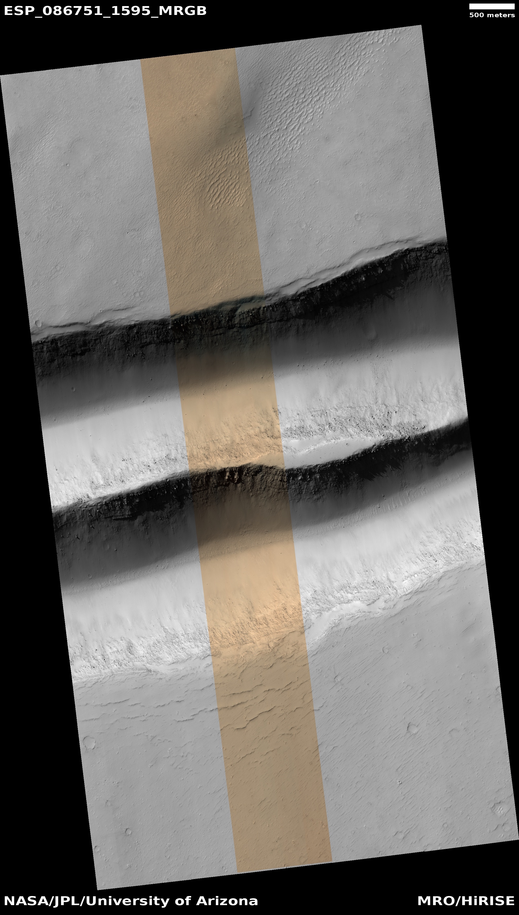
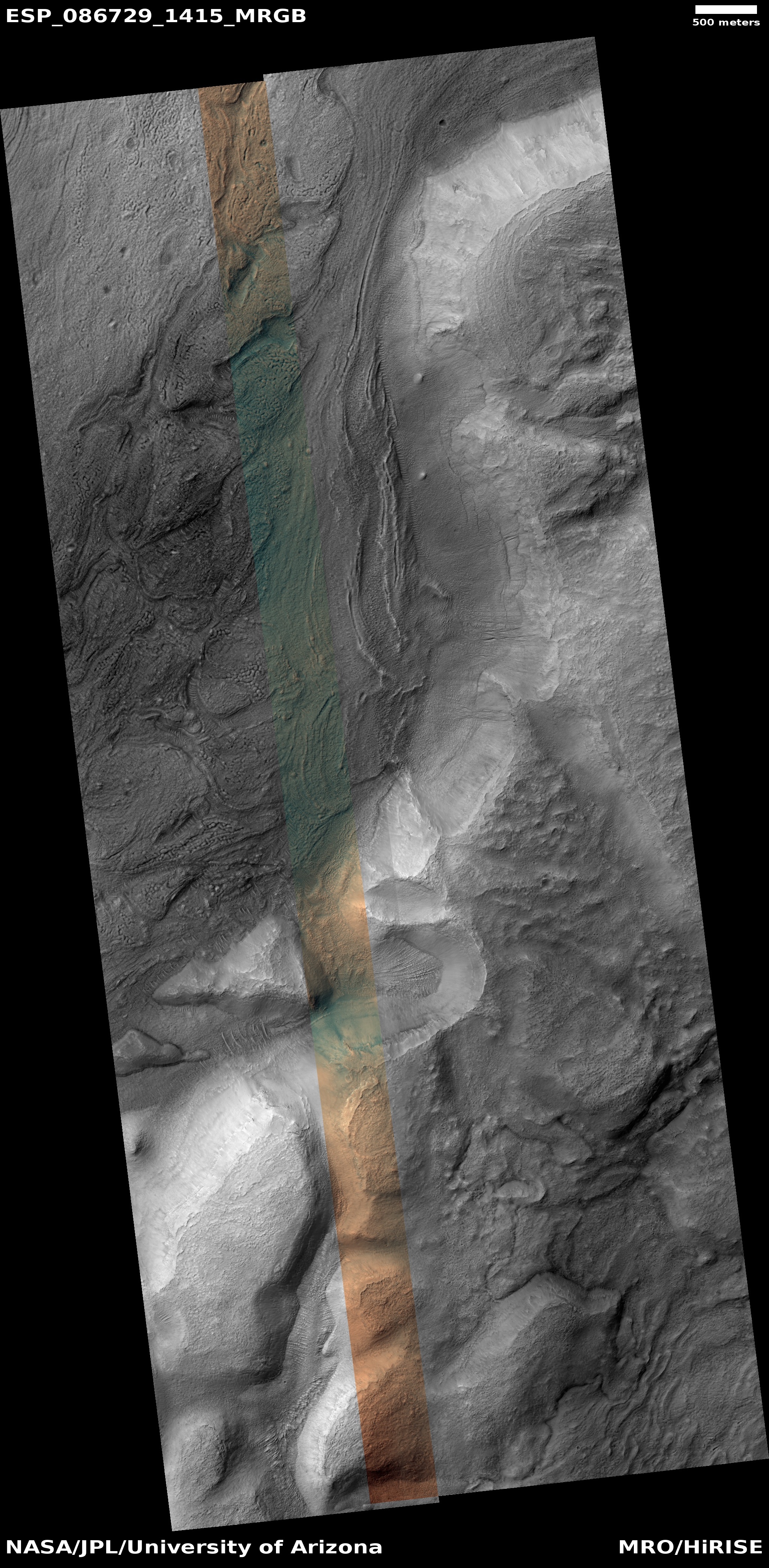
Cool image time! The picture to the right, cropped, reduced, and sharpened to post here, was taken on January 26, 2025 by the high resolution camera on Mars Reconnaissance Orbiter (MRO). The science team labeled it “Looking for Gullies” because the researchers were likely searching for such geological features on the cliff wall that runs down the right side of the picture.

What is more significant however about this picture is the glacier features in the canyon below that cliff. The downhill grade is to the southwest, and it is very evident that the canyon is filled with glacial-type debris, flowing down that grade. Along the base of the cliff the flow seems focused but squeezed, the larger blocks to the west moving slower and thus acting like a wall themselves. In between the flow moves like rapids in a narrow part of a river, albeit in slow motion.
» Read more

0 comments

Curiosity’s recent travels as seen from orbit

The view of Curiosity from orbit
Click for original image.

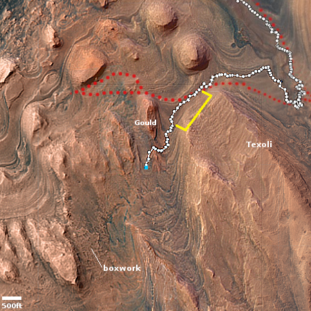
Oveview map
Click for interactive map.

Cool image time! Using Mars Reconnaissance Orbiter (MRO), scientists have captured a very cool image of Curiosity in its recent travels on Mars. That picture is above, reduced and sharpened to post here.

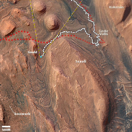
Taken by the HiRISE (High-Resolution Imaging Science Experiment) camera aboard NASAโ€™s Mars Reconnaissance Orbiter, the image shows Curiosity as a dark speck at the front of a long trail of rover tracks. Likely to last for months before being erased by wind, the tracks span about 1,050 feet (320 meters). They represent roughly 11 drives starting on Feb. 2 as Curiosity trucked along at a top speed of 0.1 mph (0.16 kph) from Gediz Vallis channel on the journey to its next science stop: a region with potential boxwork formations, possibly made by groundwater billions of years ago.

The overview map to the right provides some context. Curiosity’s present position is indicated by the blue dot. The yellow lines indicate the approximate section of its past travels photographed by the picture above.

According to the press release at the link, the science team is now estimating the rover will arrive at the boxwork geology in about a month.

0 comments

China accelerates its schedule for its upcoming Moon/Mars missions while admitting its lunar base will take longer

Phase I of China/Russian Lunar base roadmap
The original phase I plan of Chinese-Russian lunar
base plan, from June 2021.

The new colonial movement: In several different reports today in China’s state-run press — timed to coincide with the launch of three astronauts to Tiangong-3 — Chinese officials confirmed that it has moved up the planned launch dates for both its first lunar rover as well as its Mars sample return mission, and it is also expanding its offers to the international community to partner on those missions.

At the same time it let slip the fact that it will not be establishing its lunar base on the Moon in 2030, as previously claimed. Moreover, note how this so-called accelerated schedule of lunar missions is actually behind the announced timetable outlined by China and Russia in 2021, as shown on the right. None will fly by this year, as promised.

As for the news today, first China announced that its Tianwen-3 Mars sample return mission will launch in 2028.
» Read more

6 comments

Eroding lava layers in Mars’ volcano country

Eroding lava in Mars' volcano country
Click for original image.

Cool image time! The picture to the right, cropped, reduced, and sharpened to post here, was taken on February 28, 2025 by the high resolution camera on Mars Reconnaissance Orbiter (MRO).

The scientists label this picture “enigmatic terrain.” And there are certainly mysteries here. For example, why are there scattered tiny knobs across the surface in the low areas, but not on the higher areas? Also, what caused that top layer to get stripped in places? Was it erosion from wind? Or did some other process cause that layer to vanish in these spots?

Note too that this landscape has few craters. Whatever happened here occurred recently enough that it was able to cover over the impact history from the early solar system that peppered the planets with craters as the planets formed. Though impacts continue even to this day, the impact rate is far less, which allows younger terrain like this to remain largely crater free.

The location provides us some answers, but it still leaves much of this geology a puzzlement.
» Read more

0 comments

More wheel damage detected on Curiosity

Increased wheel damage on Curiosity
Click for the Sol 4518 original image.

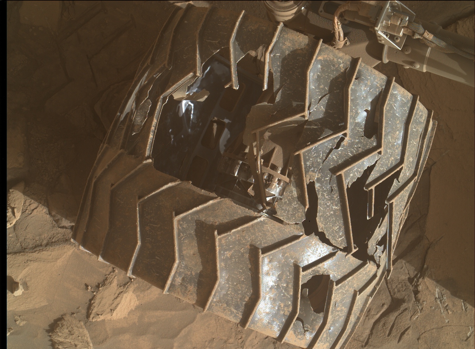
In a set of new pictures taken of Curiosity’s wheels yesterday it appears that the damage to those wheels has increased significantly in the past year, with the most damaged wheel (which based on contradictory science team reports is either the middle left or middle right wheel), having more had more sections broken to the point where this wheel might even fail in the near future.

The pictures to the right show these changes. The treads, called grousers, have been numbered to make the comparisons easier. The bottom two pictures were taken in September 2024, and look at this wheel with the damage on the side to show how a whole section of the wheel had at that time collapsed to form a depression.

The top two pictures show the increase in the damage in this section between February 2024 and yesterday. Note especially the changes in growlers 4, 5, and 6. Not only have large sections broken off in the wheel’s central section, it appears that the wheel’s outside section is beginning to separate from that central section.

The increased damage in the past year illustrated starkly the roughness of the terrain that the rover is traversing. Moreover, there is no sign that roughness is going to ease anytime in the near future. This increased damage thus explains partly why the science team changed the rover’s route to get to the nearby boxwork geology as fast as possible. That unique geology is likely to provide some important scientific information unobtainable elsewhere, and it seems worthwhile to get to it before this particular wheel fails.

There is one silver lining to this cloud. This particular wheel is a middle wheel, which means it is less critical to maintaining the rover’s stability as it travels as well as sits. The photographs of the other wheels taken today do not show as much change. Even if this wheel fails, the rover will still have five working wheels, including the most essential four corner wheels.

13 comments

Martian ridges that imitate rivers

Martian ridges that imitate rivers
Click for original image.

Cool image time! The picture to the right, cropped, reduced, and sharpened to post here, was taken on February 26, 2025 by the high resolution camera on Mars Reconnaissance Orbiter (MRO).

The scientists describe these features as “dendritic relief features,” an apt description of the thousands of miles of river-like meandering ridges that orbital images have discovered in the past decade scattered across Mars, as noted in 2016:

The inverted channels are similar to those found elsewhere on Mars and Earth. They are made of sand and gravel deposited by a river and when the river becomes dry, the channels are left upstanding as the surrounding material erodes. On Earth, inverted channels often occur in dry, desert environments like Oman, Egypt, or Utah, where erosion rates are low โ€“ in most other environments, the channels are worn away before they can become inverted.

The most dramatic example of these Martian ridge rivers are the fernlike ridges in Antoniadi Crater. The ridges to the right however are almost as striking.
» Read more

2 comments

Curiosity drill cores suggest there are more carbon-based minerals on Mars than previously believed

The uncertainty of science: Scientists studying four different core samples drilled by the Mars rover Curiosity have detected abundant amounts of the iron carbonate mineral siderite, suggesting that there is more carbon within Mars’ crust than previously believed.

If that quantity of carbon is confirmed, there might also have been a carbon cycle between Mars’s atmosphere and the liquid water theorized to have once been on the surface. This cycle could also have made the atmosphere both thicker and warmer, conditions necessary for that liquid water to exist on the surface. From the research paper:

[D]ecomposition of siderite occurred in multiple locations and released CO2 into the atmosphere, recycling CO2 that was originally sequestered during siderite formation. Diagenetic carbonate destruction observed elsewhere on Mars, in martian meteorites, and in sandstones on Earth yields nearly identical reaction products to those we found in Gale crater and are observed globally in orbital data. We therefore conclude that in situ, orbital, and terrestrial analog evidence all indicate that postdepositional alteration of siderite closed the loop in Marsโ€™ carbon cycle, by returning CO2 to the atmosphere.

The uncertainties here are gigantic. For these conclusions to be right, the scientists extrapolate without evidence the same amount of CO2 found in these four cores as existing across the entire surface of Mars. That is a very big extrapolation that no one should take very seriously.

Furthermore, this research assumes the geological features we see on Mars were formed from liquid water. More recent orbital data suggests glacial and ice processes might have played a part instead, with one study concluding that Gale Crater was never warm enough for long-standing liquid water, and that ice and glacial processes must have played the larger part in forming what we find there.

The data from these core samples however is intriguing for sure, though it mostly raises more questions about Mars’ past geological history than it answers.

0 comments

Curiosity marches on

Curiosity looks down hill
Click for original image.

The science team for the Mars rover Curiosity has been moving the rover as fast as it can in order to get to the intriguing boxwork geology about a half mile to the west and slightly higher on Mount Sharp.

The image to the right, cropped, reduced, and sharpened to post here, was taken today by the rover’s left navigation camera, and looks downhill to the north from within the parallel canyon Curiosity entered earlier this week. Because the Martian atmosphere was especially clear at the time, the mountains that form the rim of Gale Crater are quite distinct, 20 to 30 miles away. The view down the canyon also provides a vista of the crater’s floor, more than 3,000 feet below.

In the past two Martian days the science team has had the rover climb uphill a total of 364 feet, a remarkably fast pace considering the rocky nature of the terrain. It appears the engineers have done a spectacular job refining the rover’s software so that it is possible for it to pick its way autonomously through this minefield of rocks, and do so without subjecting its already damaged wheels to more damage.
» Read more

3 comments

Myriad flows on mountainous inner crater wall on Mars

Myriad flows in a crater rim
Click for original image.

Cool image time! The picture to the right, rotated, cropped, reduced, and sharpened to post here, was taken on February 27, 2025 by the high resolution camera on Mars Reconnaissance Orbiter (MRO).

That the science team labels this “Monitoring Slopes for Changes on Eastern Terraces of Mojave Crater” is quite understandable. The number of apparent dentritic channels suggests strongly the possibility of change over time, which is why MRO has been used repeatedly to monitor this location, beginning in 2006, when the science team noted this in a caption:

Aptly-named Mojave Crater in the Xanthe Terra region has alluvial fans that look remarkably similar to landforms in the Mojave Desert of southeastern California and portions of Nevada and Arizona.

Alluvial fans are fan-shaped deposits of water-transported material (alluvium). They typically form at the base of hills or mountains where there is a marked break, or flattening of slope. They typically deposit big rocks near their mouths (close to the mountains) and smaller rocks at greater distances. Alluvial fans form as a result of heavy desert downpours, typically thundershowers. Because deserts are poorly vegetated, heavy and short-lived downpours create a great deal of erosion and nearby deposition.

There are fans inside and around the outsides of Mojave crater on Mars that perfectly match the morphology of alluvial fans on Earth, with the exception of a few small impact craters dotting this Martian landscape.

» Read more

1 comment

The mighty scale of Mars’ geology

The mighty scale of Mars
Click for original image.

Today’s cool image is just one more example out of hundreds I have posted in the past decade of the difficult-to-imagine gigantic scale of the Martian landscape.

The picture to the right, rotated, cropped, reduced, and sharpened to post here, was taken on March 1, 2025 by the high resolution camera on Mars Reconnaissance Orbiter (MRO). The image title is simple, “Steep Slopes of Olympus Mons Caldera,” and tells us that this cliff face, about 1,300 feet high, is part of the caldera that resides on top of Mars’ largest volcano, Olympus Mons.

The parallel cracks on the plateau above the cliff tell us that the cliff face is slowly separating outward from that plateau, and that at some point in the future the entire wall will collapse downward.

Sounds impressive and big, eh? What the picture doesn’t make clear however is how truly tiny this cliff is in the context of the entire mountain.
» Read more

3 comments

Another “What the heck?!” image on Mars

Another
Click for original image.

Cool image time! The picture to the right, cropped, reduced, and sharpened to post here, was taken on March 2, 2025 by the high resolution camera on Mars Reconnaissance Orbiter (MRO).

The scientists label this “Monitoring Irregular Terrains in Western Arabia Terra.” I label it more bluntly as another one of MRO’s “What the heck?!” images. For all I know, this is nothing more than a discarded Vincent Van Gogh painting, thrown out because even he couldn’t figure out what he was painting.

The best guess I can make, just from the picture alone, is that some of the dark spots are vents from which the white stuff vented at some point, either as small lava or mud volcanoes. As the location is close to the equator, near surface ice is almost certainly not a factor in what we see.

In any case there is no way to reasonably decipher this picture, just by looking at the picture. It is necessary to take a wider view.
» Read more

1 comment

Terraces within one of Mars’ giant enclosed chasms

Overview map

Terraces within Hebes Chasma

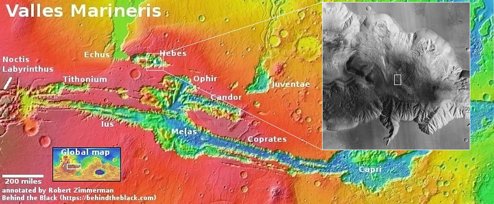
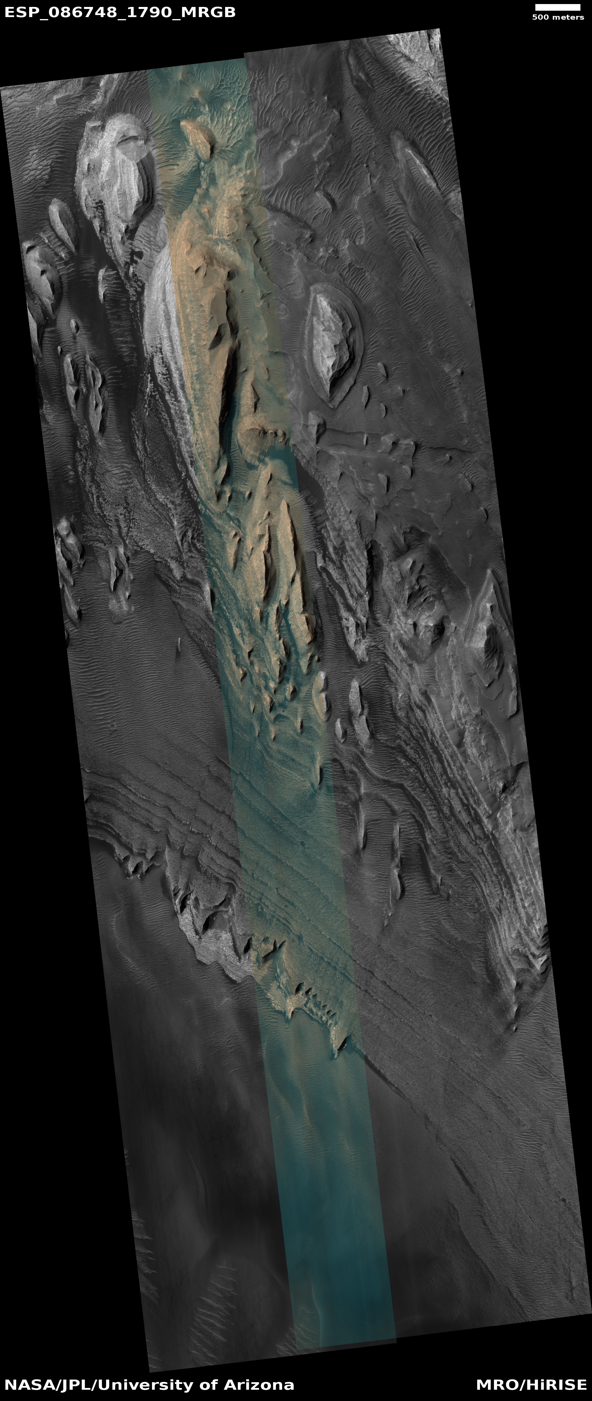
Cool image time! The picture to the right, rotated, cropped, reduced, and sharpened to post here, was taken on January 27, 2025 by the high resolution camera on Mars Reconnaissance Orbiter (MRO). It shows the terraced layers descending down a 7,000-foot-high ridgeline within Hebes Chasma, one of several enclosed chasms that are found to the north of Mars’s largest canyon system, Valles Marineris.

The white dot on the overview map above marks this location, inside Hebes. The rectangle in the inset indicates the area covered by the picture, which only covers the lower 5,000 feet of this ridge’s southern flank.

The ridgeline might be 7,000 feet high and sixteen miles long, but it is dwarfed by the scale of the chasm within which it sits. From the rim to the floor of Hebes is a 23,000 foot drop, comparable to the general heights of the Himalaya Mountains. Furthermore, this ridge is not the highest peak within Hebes. To the west is the much larger mesa dubbed Hebes Mensa, 11,000 feet high and 55 miles long.

The terraces indicate the cyclical and complex geological history of Mars. Each probably represents a major volcanic eruption, laying down a new bed of flood lava. With time, something caused Hebes Chasm to get excavated, exposing this ridge and these layers.

The excavation process itself remains unclear. Some scientists think the entire Valles Marineris canyon was created by catastrophic floods of liquid water. Others posit the possibility of underground ice aquifers that sublimated away, causing the surface to sink, eroded further by wind. Neither theory is proven, though the former is generally favored by scientists.

0 comments

Another example of the weird taffy terrain in Mars’ death valley

More taffy terrain

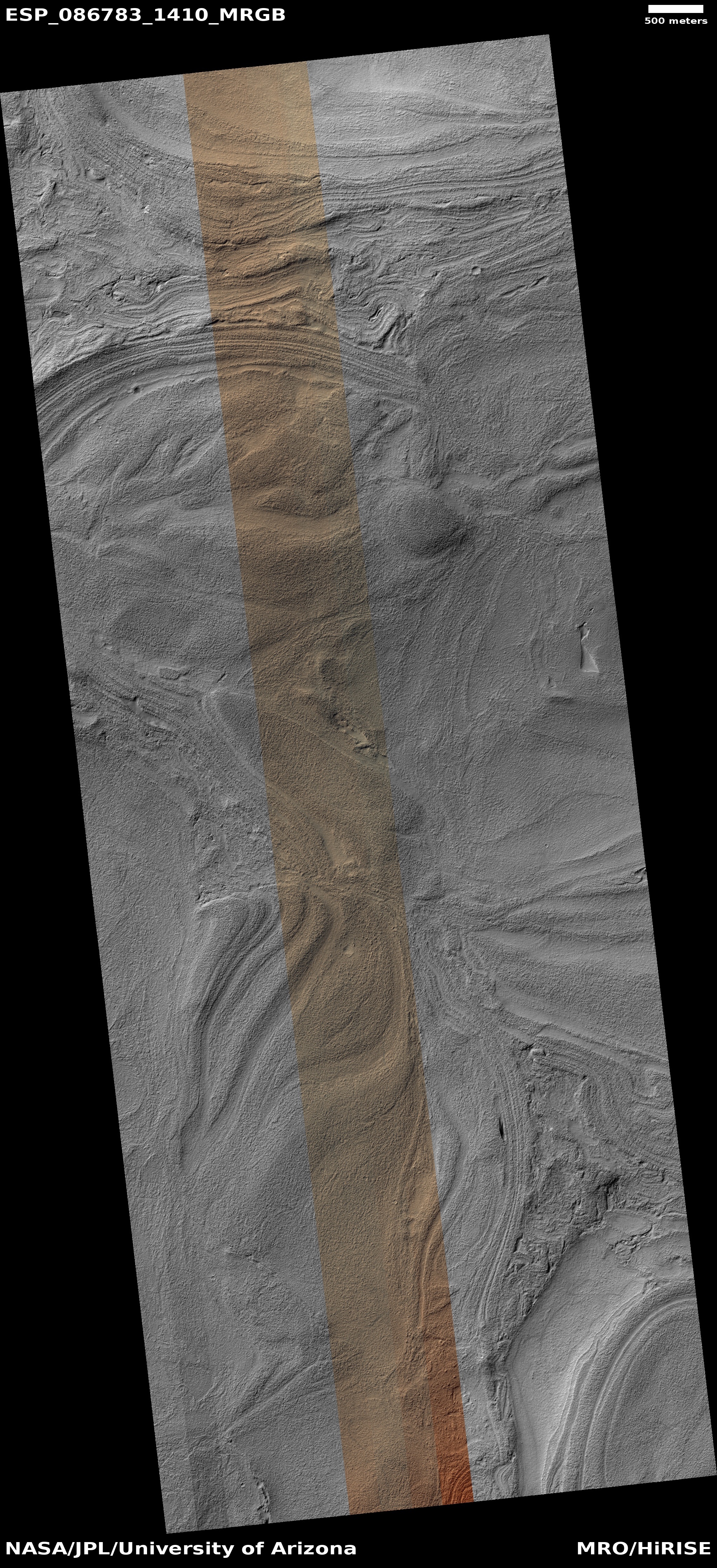
Cool image time! The picture to the right, rotated, cropped, reduced, and enhanced to post here, was taken on January 30, 2025 by the high resolution camera on Mars Reconnaissance Orbiter (MRO).

The scientists label it dimply as “layers in Helles Planitia.” Other scientists have given this strange landscape a much more interesting label, “taffy terrain.” It is found only in the Hellas Basin, the basement of Mars, having the lowest elevation found anywhere on the red planet. According to a 2014 paper, the scientists posit that this material must be some sort of “a viscous fluid,” naturally flowing downward into “localized depressions.” Because of its weird nature I have posted many cool images of it in the past (see here, here, here, here, and here).

Is taffy terrain still viscous, or has it become solidified? That question I think remains unanswered, though pictures taken of the same spot over time do not yet appear to show changes.
» Read more

0 comments

Airbus wins contract to build lander for Europe’s long delayed ExoMars Franklin rover

Low resolution cropped section of map
Geology map for Franklin landing site. Click for
original image. Click here for original article.

The European Space Agency (ESA) late yesterday announced that it has awarded Airbus a $194 million contract to build the lander that will place Europe’s long delayed ExoMars Franklin rover on the Martian surface, replacing the Russian lander that became unavailable when the ESA/Russian partnership ended after Russia invaded the Ukraine in 2022.

Airbus announced late March 28 (Eastern time) that it was selected by ESA and Thales Alenia Space, the prime contractor for the mission, to build the landing platform for that rover mission, scheduled to launch in 2028.

The landing platform is the part of the ExoMars spacecraft that handles the final phases of its descent to the Martian surface in 2030, including performing the final landing burn. After landing, the platform will deploy ramps to allow the ExoMars rover, named Rosalind Franklin, to roll onto the Martian surface.

This project was first begun in the early 2010s, with a launch date targeting 2018. Initially a partnership between ESA and NASA, Obama canceled all American participation in 2012. Russia picked up the slack, but then the mission had numerous technical problems that caused it to miss first that 2018 launch window, and then 2020 window as well. Then, just months before launch in 2022, Russia invaded the Ukraine, resulting in Europe ending all its partnership deals with Russia.

The mission is now working to launch in the 2028 window. We shall see if it can meet that date.

3 comments

Martian stucco

Martian stucco
Click for original image.

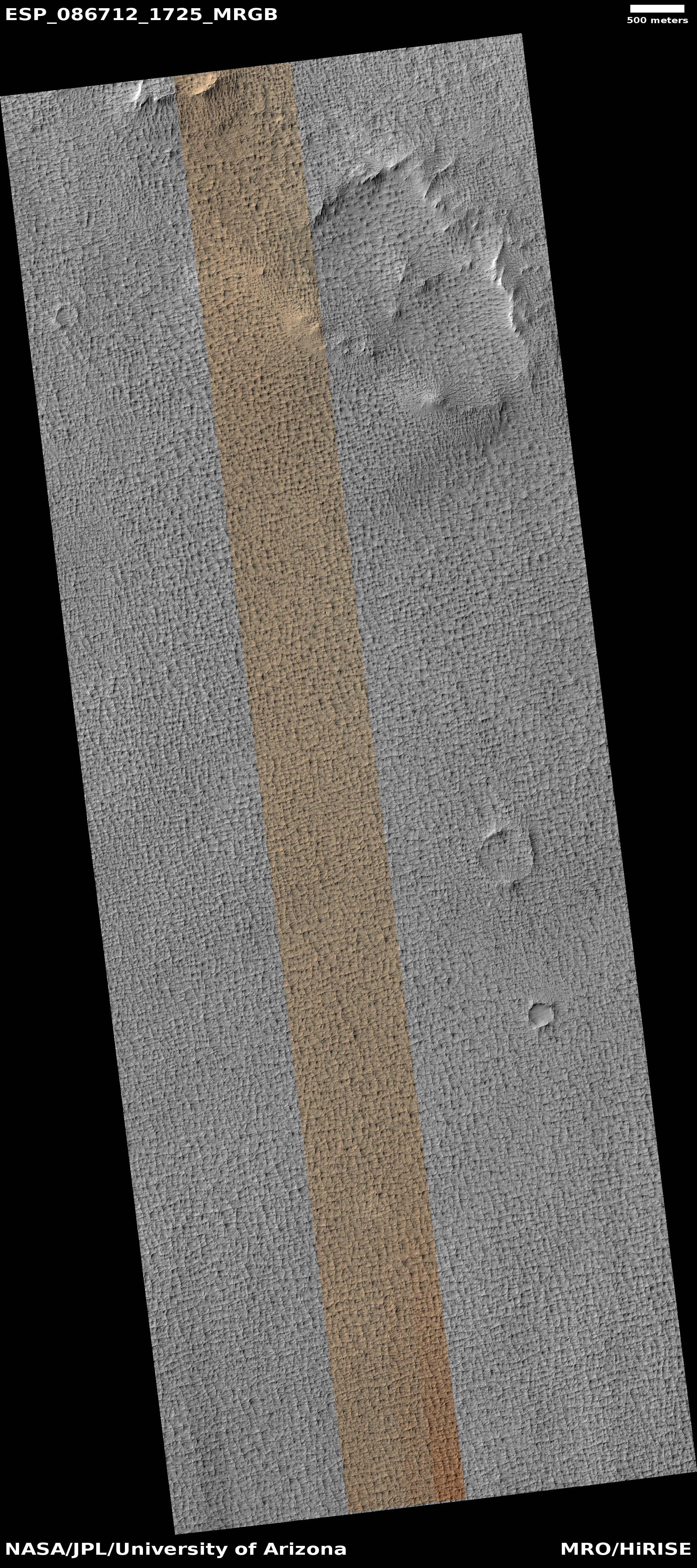
Cool image time! The picture to the right, cropped, reduced, and sharpened to post here, was taken on January 24, 2025 by the high resolution camera on Mars Reconnaissance Orbiter (MRO). Labeled simply as a “terrain sample,” it was likely taken not as part of any specific research request but to fill a gap in the schedule in order to maintain the camera’s proper temperature.

In this case the camera team got something quite intriguing. The entire terrain is reminiscent of stucco found on the outside walls of southwest homes. What makes even more intriguing is that the stucco appears to be material that has covered the terrain, based on the two craters that appear half-buried by it. Moreover, this picture only captures a small portion of this landscape, which extends like this over an area approximately 40 miles squared.

What caused this strange terrain? As always, the overview map below provides a clue, though no firm answers.
» Read more

0 comments

Scientists believe they have found evidence of largest carbon molecules yet in Curiosity drill sample

The uncertainty of science: Scientists analyzing material drilled out by the Mars rover Curiosity back in 2013 now believe the sample included the largest carbon molecules yet found on Mars.

The detection of these long and large carbon molecules was based not on actual Martian data, taken at a site dubbed Cumberland on the floor of Gale Crater, but on follow-up lab work on Earth.

The recent organic compounds discovery was a side effect of an unrelated experiment to probe Cumberland for signs of amino acids, which are the building blocks of proteins. After heating the sample twice in [the Curiosity] SAMโ€™s oven and then measuring the mass of the molecules released, the team saw no evidence of amino acids. But they noticed that the sample released small amounts of decane, undecane, and dodecane [thought to be fragments of fatty acids].

Because these compounds could have broken off from larger molecules during heating, scientists worked backward to figure out what structures they may have come from. They hypothesized these molecules were remnants of the fatty acids undecanoic acid, dodecanoic acid, and tridecanoic acid, respectively.

The scientists tested their prediction in the lab, mixing undecanoic acid into a Mars-like clay and conducting a SAM-like experiment. After being heated, the undecanoic acid released decane, as predicted. The researchers then referenced experiments already published by other scientists to show that the undecane could have broken off from dodecanoic acid and dodecane from tridecanoic acid.

Based on this Earth lab work, the scientists now suggest that Mars could also have these much longer carbon molecules that are associated with biological processes.

Very intriguing, but we must exercise caution. Curiosity did not detect such molecules, only evidence that they might exist on Mars. And even if they do exist on Mars, this is not evidence that Mars has or once had biological life. While such large molecules on Earth are usually associated with biological processes, they do not have to be, as the scientists readily admit in their abstract. Furthermore, in the alien environment of Mars there could be many non-biological processes we don’t even yet understand that could explain their existence.

0 comments

Perseverance spots a rock made of many tiny spherules

Rock made of spherules found by Perseverance
Click for wide shot. The original of the inset
can be found here.

In their exploration of the outer flanks of the rim of Jezero Crater, the science team operating the Perseverance rover have discovered an unusual rock different than everything around it, appearing to be made of many very tiny spherules.

The picture to the right illustrates this. The wider picture was taken by Perseverance’s left high resolution camera, with the inset a close-up mosaic of three images taken by the rover’s micro-imager, designed to get very very high resolution pictures of small objects. From the press release:

The rock, named โ€œSt. Pauls Bayโ€ by the team, appeared to be comprised of hundreds of millimeter-sized, dark gray spheres. Some of these occurred as more elongate, elliptical shapes, while others possessed angular edges, perhaps representing broken spherule fragments. Some spheres even possessed tiny pinholes! What quirk of geology could produce these strange shapes?

This isnโ€™t the first time strange spheres have been spotted on Mars. In 2004, the Mars Exploration Rover Opportunity spotted so-called, โ€œMartian Blueberriesโ€ at Meridiani Planum, and since then, the Curiosity rover has observed spherules in the rocks of Yellowknife Bay at Gale crater. Just a few months ago, Perseverance itself also spied popcorn-like textures in sedimentary rocks exposed in the Jezero crater inlet channel, Neretva Vallis. In each of these cases, the spherules were interpreted as concretions, features that formed by interaction with groundwater circulating through pore spaces in the rock.

Not all spherules form this way, however. They also form on Earth by rapid cooling of molten rock droplets formed in a volcanic eruption, for instance, or by the condensation of rock vaporized by a meteorite impact.

At the moment the science team has no idea which of these theories explains the spherules. That the rock is located on the crater rim, where ejecta from the impact will be found, strongly suggests the impact was the cause, not groundwater flow.

7 comments

High ridge down the center of a big Martian crack

High ridge down the middle of a Martian canyon
Click for original image.

Cool image time! The picture to the right, rotated, cropped, reduced, and sharpened to post here, was taken on January 27, 2025 by the high resolution camera on Mars Reconnaissance Orbiter (MRO). Labeled simply as a “terrain sample,” it was likely taken not as part of any specific research project but to fill a gap in the schedule in order to maintain the camera’s proper temperature.

Whenever the camera team needs to do this, they try to find an interesting object to photograph, and often succeed. In this case they focused on the geology to the right. I suspect that at first glance my readers will have trouble deciphering what they are looking at. Let me elucidate: This this a 2.5-mile-wide canyon, about 1,000 feet deep, that is bisected by a ridge about 500 feet high.

On the sunlight walls of this canyon you can see boulders and debris, with material gathered on the canyon floor. The smoothness of the floor suggests also that a lot of Martian dust, likely volcanic ash, has become trapped there over the eons.
» Read more

0 comments

Curiosity’s newest view from the heights

Mars in its glorious barrenness
Click for original image.

Overview map
Click for interactive map.

Cool image time! The panorama above, cropped slightly to post here, was taken today by the right navigation camera on the Mars rover Curiosity. It looks north from the rover’s present location on the flank of Mount Sharp, with the rim of Gale Crater in the far distance about 20 to 30 miles away. Curiosity now sits about 3,000 feet above the floor of the crater.

The blue dot on the overview map to the right marks the rover’s position at this time. The yellow lines indicate the approximate view of the panorama. As with all of the images from both Curiosity and Perseverance, the main impression is a barren and lifeless landscape of incredible stark beauty.

It is now very evident that the Curiosity science team has made the decision to abandon their original route to the west. Instead, they have decided to strike south up into this canyon because it provides them the easiest and fastest route to the boxwork geology to the southwest. It also has them climbing into new geological layers rather than descending into layers that the rover has already seen.

3 comments

The next time someone tells you Mars lacks water, show them this picture

Lots of near surface ice on Mars
Click for original image.

In the past decade orbital images from Mars have shown unequivocally that the Red Planet is not the dry desert imagined by sci-fi writers for many decades prior to the space age. Nor is it the dry desert that planetary scientists had first concluded based on the first few decades of planetary missions there.

No, what the orbiters Mars Reconnaissance Orbiter (MRO) and Mars Express have clearly shown is that, except for the planet’s equatorial regions below 30 degrees latitude, the Martian surface is almost entirely covered by water ice, though it is almost always buried by a thin layer of protective dust and debris. Getting to that ice will be somewhat trivial, however, as it is almost always near the surface.

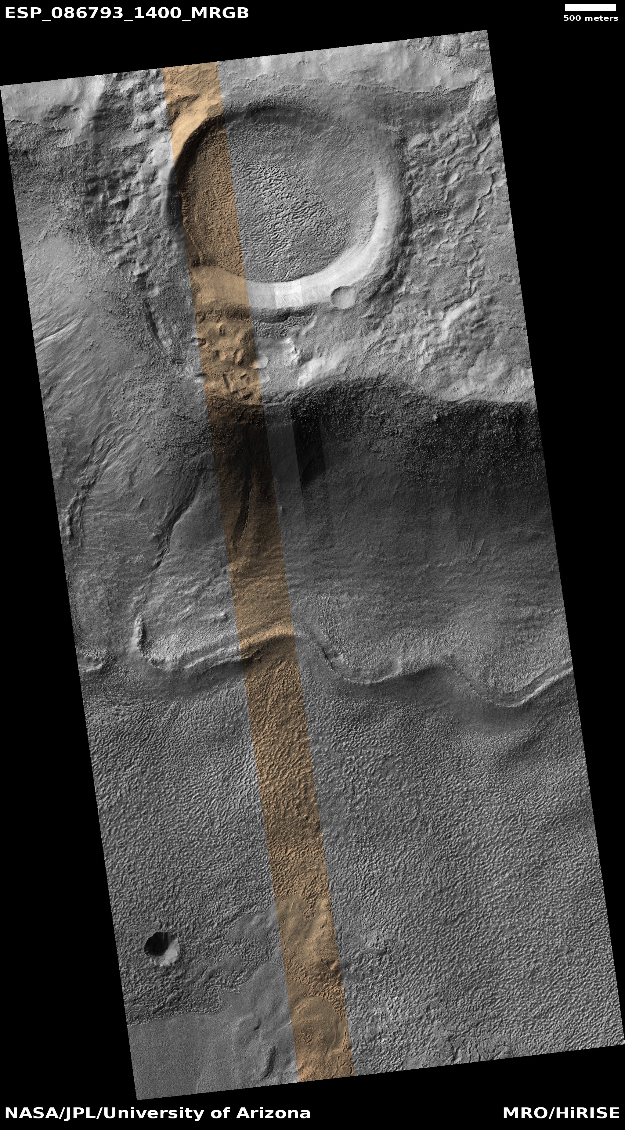
The picture to the right, rotated, cropped, reduced, and sharpened to post here, is a perfect example. It was taken on January 31, 2025 by the high resolution camera on MRO. At the top it shows part of a small glacial-filled crater surrounded by blobby ground clearly impregnated with ice. That crater in turn sits on the rim of a much larger very-eroded ancient 53-mile-wide crater whose floor, also filled with glacial debris, can be seen at the bottom of this picture. The wavy ridge line at the base of the rim appears to be a moraine formed by the ebb and flow of the glacial ice that fills this larger crater.

None of these glacial features is particularly unique on Mars. I have been documenting their presence now at Behind the Black for more than six years. Yet, I find still that most news organizations — including many in the space community — remain utterly unaware of these revelations. Any new NASA or university press release that mentions the near-surface ice that covers about two-thirds of the planet’s surface results in news stories claiming “Water has been found on Mars!”, as if this is a shocking new fact from a place where little water is found.

It is very shameful that so many reporters and news organizations are so far out of touch with the actual state of the research on Mars.
» Read more

11 comments
1 7 8 9 10 11 128