February 21, 2020 Zimmerman/Batchelor podcast
Embedded below the fold in two posts.
» Read more
Embedded below the fold in two posts.
» Read more

Click for full image.
The OSIRIS-REx science team today released one of the images taken during the spacecraft’s recent close reconnaissance of its secondary touch-and-go landing site on the asteroid Bennu.
I have cropped their oblique image to focus, in full resolution, on that landing site, dubbed Osprey, which is the crater on the left side of the photo. The boulder in that crater “is 17 ft (5.2 m) long, which is about the length of a box truck.”
After the fly-by, the science team had announced that the spacecraft’s laser altimeter had failed to operate, and the images taken by its highest resolution camera (not the camera that took today’s image) “are likely out of focus.”
Based on this image, what look like tiny pebbles inside the crater are actually boulders ranging in size from mere inches to as much as five feet across. If their high resolution images are soft, it will thus be hard to map out the terrain sufficiently to safely make a touch-and-go landing here.
More important, there is still no word on whether they have fixed the laser altimeter. Without it I suspect a landing will be very difficult, if not impossible.
Capitalism in space: According to anonymous sources, SpaceX is once again seeking more investment capital, this time totaling $250 million.
Last year the company raised $1.33 billion. While not as much as the personal cash that Jeff Bezos has raised for Blue Origin by selling his personal Amazon stock, it has been enough for SpaceX to accomplish far more. Not only is the company about to launch its first manned mission, it has quickly begun assembling its Starlink internet constellation in orbit, while pushing forward on Starship construction.
NASA on February 20, 2020 finally admitted that the first SLS launch cannot happen in 2020, and set a new target date no earlier than April 18, 2021.
The previous target launch date in November 2020 was always a pure fantasy. NASA just held off admitting it in order to defuse any political consequences for having a program, building SLS, that will end up taking them almost two decades to complete.
This new launch date is likely the most realistic so far, since the hardware for SLS is actually finally coming together. Nonetheless, if anything at all should go wrong along the way, especially with the full static test firing of the core booster of the first stage scheduled for no earlier than August, then expect more delays, possibly lasting years.
Insight’s engineers, having failed to get its mole pile driver to dig down as planned, now plan to use the lander’s scoop to push on the mole in the hope this will prevent it from popping up with each hammer drive.
[T]he mole is a 16-inch-long (40-centimeter-long) spike equipped with an internal hammering mechanism. While burrowing into the soil, it is designed to drag with it a ribbonlike tether that extends from the spacecraft. Temperature sensors are embedded along the tether to measure heat coming deep from within the planet’s interior.
…The team has avoided pushing on the back cap [at the top of the mole] until now to avoid any potential damage to the tether.
It appears to me that they are running out of options. This new attempt carries risks. It could damage the tether required to obtain underground temperature readings, the prime purpose of the experiment. However, if they don’t get the tether into the ground, this will also prevent the experiment from functioning. Thus, this attempt could essentially be a Hail Mary pass, gambling all on one last all-or-nothing gambit.
Capitalism in space: Airbus announced this week that it plans to cut 2,362 jobs, citing as the reason “lower performance in space” as well as postponed defense contracts.
This quote from the article is revealing:
Airbus Defence and Space is the third satellite manufacturer to announce layoffs in the past 12 months. Thales Alenia Space said in September it was cutting around 6% of its workforce, following Maxar’s February 2019 announcement that it would dismiss roughly 3% of its employees.
The article however also indicates that 2019 saw a big recovery in geosynchronous satellite orders.
Though not stated, I suspect that part of Airbus’s problem is related to Ariane 6, which it is building in a joint partnership with Safran dubbed ArianeGroup. While designed to be less expensive to build, the rocket is not reusable, and its launch price is simply not competitive. Thus, getting contract orders has been very difficult.
Note also that ArianeGroup announced in November 2018 that it going to cut 2,300 jobs by 2022. I wonder if some of these cuts overlap the newly announced cuts.
Either way, these trims might be a good thing as Airbus and ArianeGroup work to cut their costs. Or they could be a bad thing, indicating that both are having trouble making sales. Only time will tell.
An evening pause: Technology developed with slide rules and the English system of measurements, more than half a century ago, that still works today.
Hat tip Tom Biggar.

Click for full image.
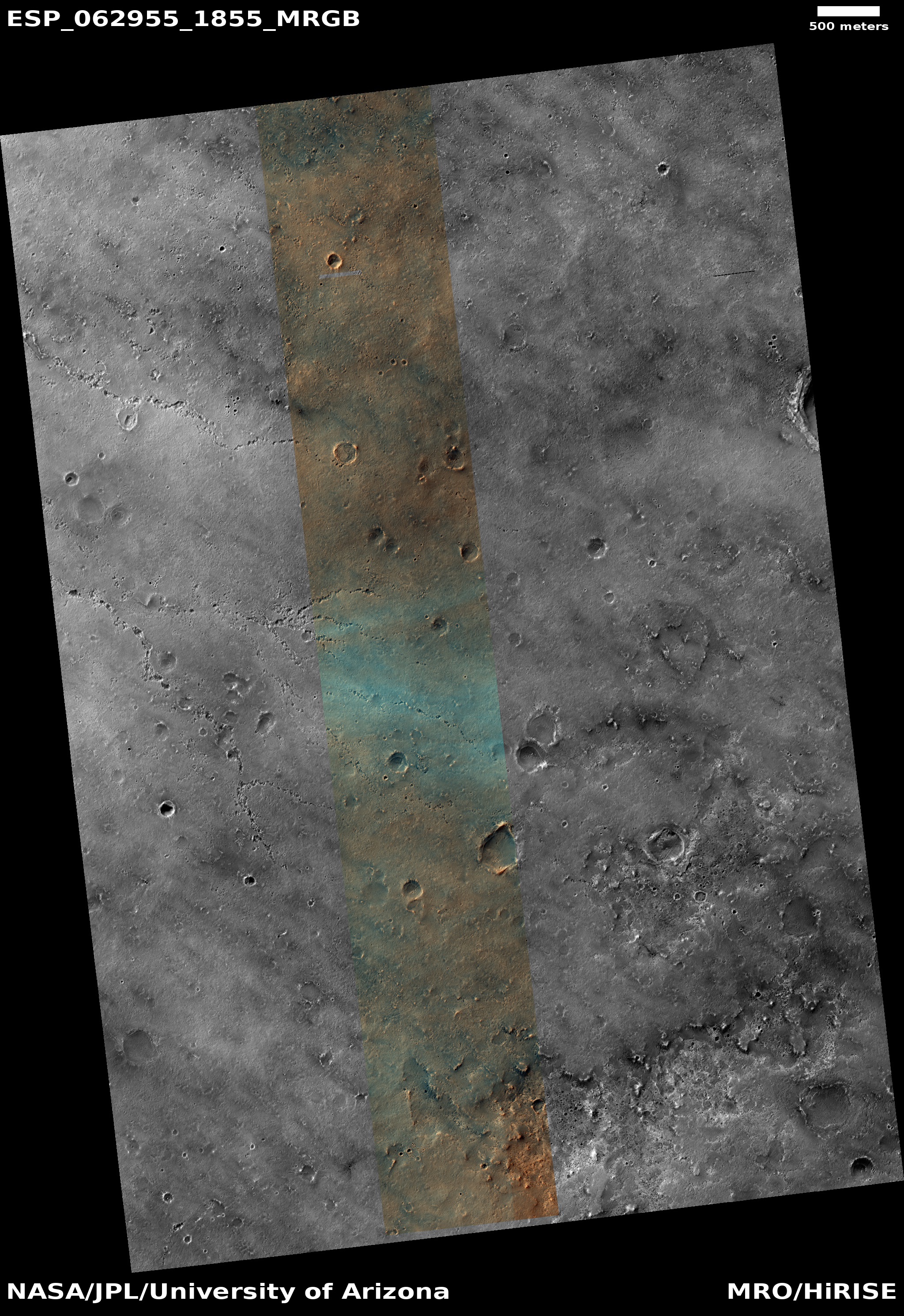
The image to the right, rotated, cropped and reduced to post here, was taken on December 19, 2019 by the high resolution camera on Mars Reconnaissance Orbiter (MRO). Labeled “Head of Mamers Valles”, it shows the very end of one side canyon to this very extensive canyon system made up of the fractured fissures and mesas of chaos terrain.
Mamers Valles itself sits in the transition zone between the northern lowland plains and the southern cratered highlands. This specific canyon is close to those lowlands, at a latitude of 40 degrees north, where scientists believe there are many buried inactive glaciers of ice.
The image reinforces this belief. The entire canyon appears practically filled with what looks like ice. In fact, it almost looks like we are looking down at a frozen lake with a layer of snow on top of it. In this case, the layer is not snow, but dust and dirt and debris that covers the ice to protect it and prevent it from sublimating away.
The overview map below shows the location of this canyon, by the red cross, within Mamers Valles.
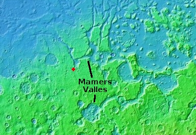
Mamers Valles is actually a very large collection of miscellaneous canyons, flowing into the lowlands. In some areas it looks like very old chaos terrain, with the canyons so eroded that all we see are scattered mesas. In other places the canyons more resemble meandering river canyons sometimes interspersed with crater impacts.
Scientists have analyzed the canyons in Mamers Valles, and from this concluded that they were likely formed from “subsurface hydrologic activity”. which in plain English means that flowing water below ground washed out large underground passages, which eventually grew large enough for their ceilings to collapse and form the canyons we see today.
Yesterday I posted an image of a string of pits that could very well be evidence of this same process in its early stages of canyon formation. In Mamers Valles the process is far more advanced, and the canyons have existed for a long time, long enough for the planet’s inclination to go through several cycles of change, from a low of 25 degrees tilt (what it is now) to has high as 60 degrees. At that high inclination the mid-latitudes were colder than the poles, so that ice would sublimate from the poles to fall as snow in the mid-latitudes, forming active glaciers within canyons such as this.
Now that the planet’s inclination is similar to Earth’s, 25 degrees, the poles are slightly colder than the mid-latitudes, and the glaciers in this canyon are either inactive (if buried) or slowly sublimating away so that the water can return to the poles.
Here however the surface debris appears to be protecting the glaciers, leaving the canyon filled mostly with ice. For future settlers this ice would likely be relatively accessible, and at a latitude where the environment is also relatively mild, for Mars.
Yutu-2 has found a cluster of small rocks that appear relatively young, with little erosion.
The rocks also also appear as if they came from another place on the Moon.
Closer inspection of the rocks by the rover team revealed little erosion, which on the moon is caused by micrometeorites and the huge changes in temperature across long lunar days and nights. That anomaly suggests that the fragments are relatively young. Over time, rocks tend to erode into soils.
The relative brightness of the rocks also indicated they may have originated in an area very different to the one Yutu-2 is exploring.
Youth in this case is very relative. The rocks might be young when compared to the surface on which they sit, but they still could be more than a billion years olf.
As predicted by astronomers, Betelguese’s dimming has ceased and has even begun to brighten slightly in the past week.
The graph here and at the link shows the uptick clearly. As this was exactly what was expected if the star followed its past cyclical patterns, this strongly suggests that we will not see any supernovae from the star anytime in the near future.
An evening pause: Stay with it. It will soon remind you of modern DC politics.
Hat tip Phill Oltmann.
Click for full image.
Cool image time! As my regular readers well know, I am a caver, and am thus always interested when the high resolution camera on Mars Reconnaissance Orbiter (MRO) takes a close-up of a pit that might also be an entrance to a cave.
The photo to the right, cropped and reduced to post here, was part of the most recent image release from MRO, but was boringly labeled “Arabia Terra” after the region where it is located, one of the largest transition zones on Mars between the northern lowland plains and the southern cratered highlands. When I took a close look, what I found was an intriguing string of pits whose arrangement is strikingly reminiscent of a river tributary system.
The white box indicates one section that I have zoomed into, as shown below.
» Read more