
IAU approves 2nd set of Pluto names chosen by New Horizons team
My heart be still! The International Astronomical Union (IAU) has now officially given its glorious stamp of approval to a second set of fourteen names given by the New Horizons’ team to features on Pluto.
Several people and missions who paved the way for the historic exploration of Pluto and the Kuiper Belt – the farthest worlds ever explored – are honored in the second set of official Pluto feature names approved by the International Astronomical Union (IAU), the international authority for naming celestial bodies and their surface features.
The new names were proposed by NASA’s New Horizons team, which carried out the first reconnaissance of Pluto and its moons with the New Horizons spacecraft in 2015. Along with a short list of official names the IAU had already approved, the mission science team had been using these and other place names informally to describe the many regions, mountain ranges, plains, valleys and craters discovered during the first close-up look at Pluto’s surface. [emphasis mine]
In case you don’t get it, I am being very sarcastic above. I consider the IAU to be incredibly arrogant in its claim that it, and it alone, can approve the names given to surface features on other worlds. Initially the IAU was given the task by the astronomical community of organizing the naming of celestial bodies seen in telescopes, to reduce confusion. Somehow the IAU has expanded that responsibility to include the naming of every rock and pebble on every world in the universe.
To this I say bunk. I also know that future spacefarers in space will say the same thing, and tell the IAU to go jump in a lake. In a sense, the New Horizons team did exactly that when they made their name choices very public from the beginning, essentially telling the IAU that the New Horizons’ team is picking the names, not the IAU.
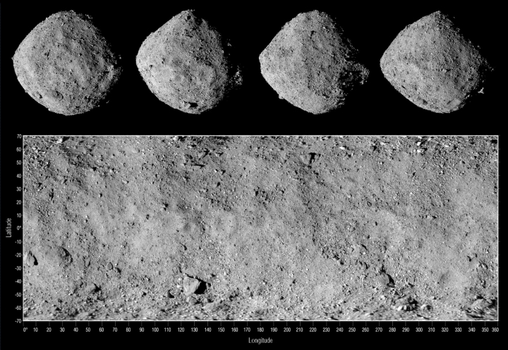
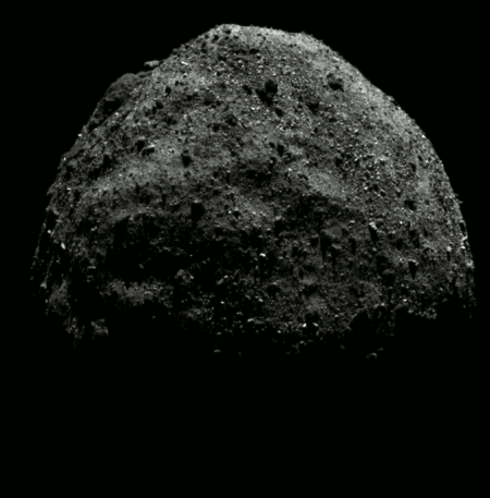
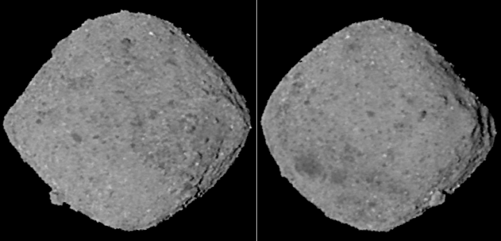
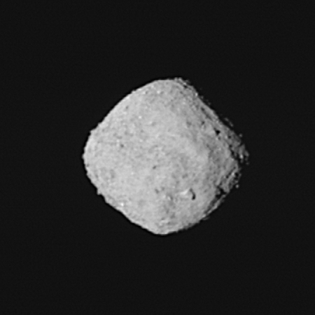
In related news, the IAU has now approved the naming convention the OSIRIS-REx team intends to use to name features on Bennu. However, in this case the IAU is doing its real job, helping to organize the naming conventions to reduce confusion.
The named features on Bennu will include several terrain classification types that the IAU also approved for asteroid (162173) Ryugu’s surface features (currently being explored by the Japanese Space Agency’s Hayabusa2 spacecraft). These include craters, dorsa (peaks or ridges), fossae (grooves or trenches) and saxa (rocks and boulders). The last of these types – saxum – is a new feature classification that the IAU introduced earlier this year for small, rocky asteroids like Ryugu and Bennu. These surface features on Bennu will be named after mythological birds and bird-like creatures, complementing the mission’s existing naming theme, which is rooted in Egyptian mythology.
The actual names the OSIRIS-REx team will chose for each unique feature will however be their choice, not the IAU’s. Though the IAU will eventually announce it has “approved” those choices, it will never really have the right to have a say in those decisions.
My heart be still! The International Astronomical Union (IAU) has now officially given its glorious stamp of approval to a second set of fourteen names given by the New Horizons’ team to features on Pluto.
Several people and missions who paved the way for the historic exploration of Pluto and the Kuiper Belt – the farthest worlds ever explored – are honored in the second set of official Pluto feature names approved by the International Astronomical Union (IAU), the international authority for naming celestial bodies and their surface features.
The new names were proposed by NASA’s New Horizons team, which carried out the first reconnaissance of Pluto and its moons with the New Horizons spacecraft in 2015. Along with a short list of official names the IAU had already approved, the mission science team had been using these and other place names informally to describe the many regions, mountain ranges, plains, valleys and craters discovered during the first close-up look at Pluto’s surface. [emphasis mine]
In case you don’t get it, I am being very sarcastic above. I consider the IAU to be incredibly arrogant in its claim that it, and it alone, can approve the names given to surface features on other worlds. Initially the IAU was given the task by the astronomical community of organizing the naming of celestial bodies seen in telescopes, to reduce confusion. Somehow the IAU has expanded that responsibility to include the naming of every rock and pebble on every world in the universe.
To this I say bunk. I also know that future spacefarers in space will say the same thing, and tell the IAU to go jump in a lake. In a sense, the New Horizons team did exactly that when they made their name choices very public from the beginning, essentially telling the IAU that the New Horizons’ team is picking the names, not the IAU.
In related news, the IAU has now approved the naming convention the OSIRIS-REx team intends to use to name features on Bennu. However, in this case the IAU is doing its real job, helping to organize the naming conventions to reduce confusion.
The named features on Bennu will include several terrain classification types that the IAU also approved for asteroid (162173) Ryugu’s surface features (currently being explored by the Japanese Space Agency’s Hayabusa2 spacecraft). These include craters, dorsa (peaks or ridges), fossae (grooves or trenches) and saxa (rocks and boulders). The last of these types – saxum – is a new feature classification that the IAU introduced earlier this year for small, rocky asteroids like Ryugu and Bennu. These surface features on Bennu will be named after mythological birds and bird-like creatures, complementing the mission’s existing naming theme, which is rooted in Egyptian mythology.
The actual names the OSIRIS-REx team will chose for each unique feature will however be their choice, not the IAU’s. Though the IAU will eventually announce it has “approved” those choices, it will never really have the right to have a say in those decisions.


