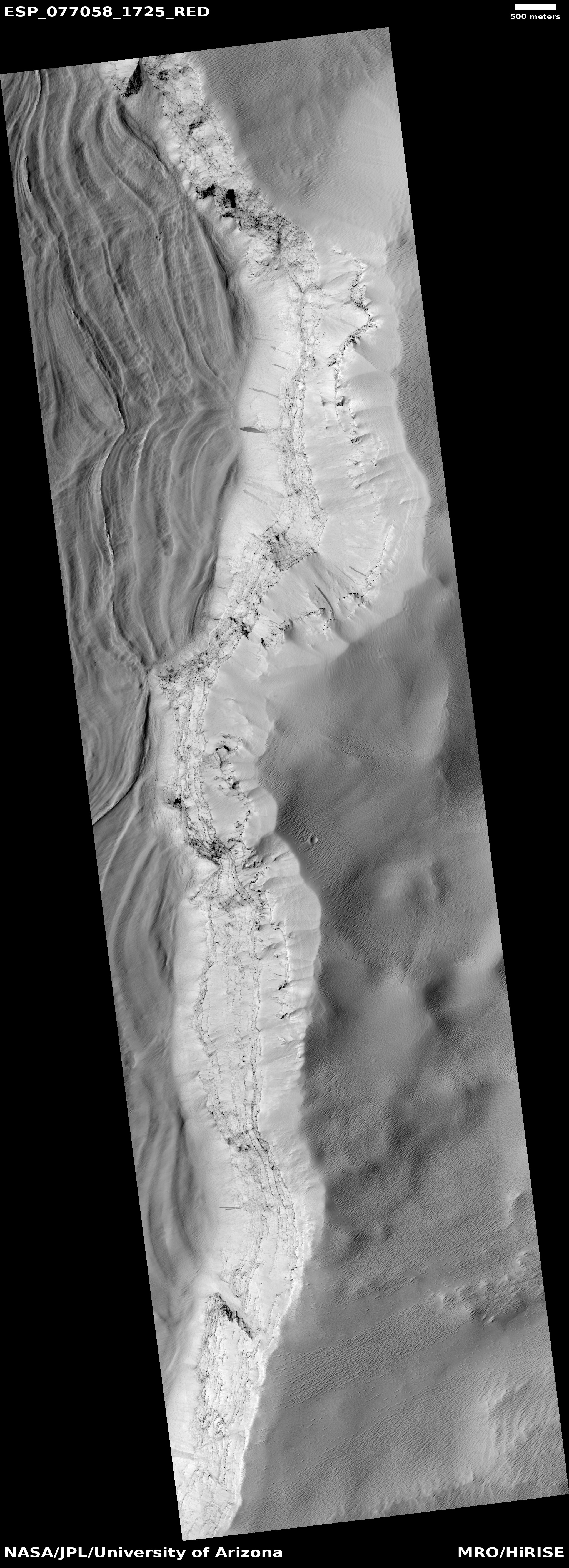
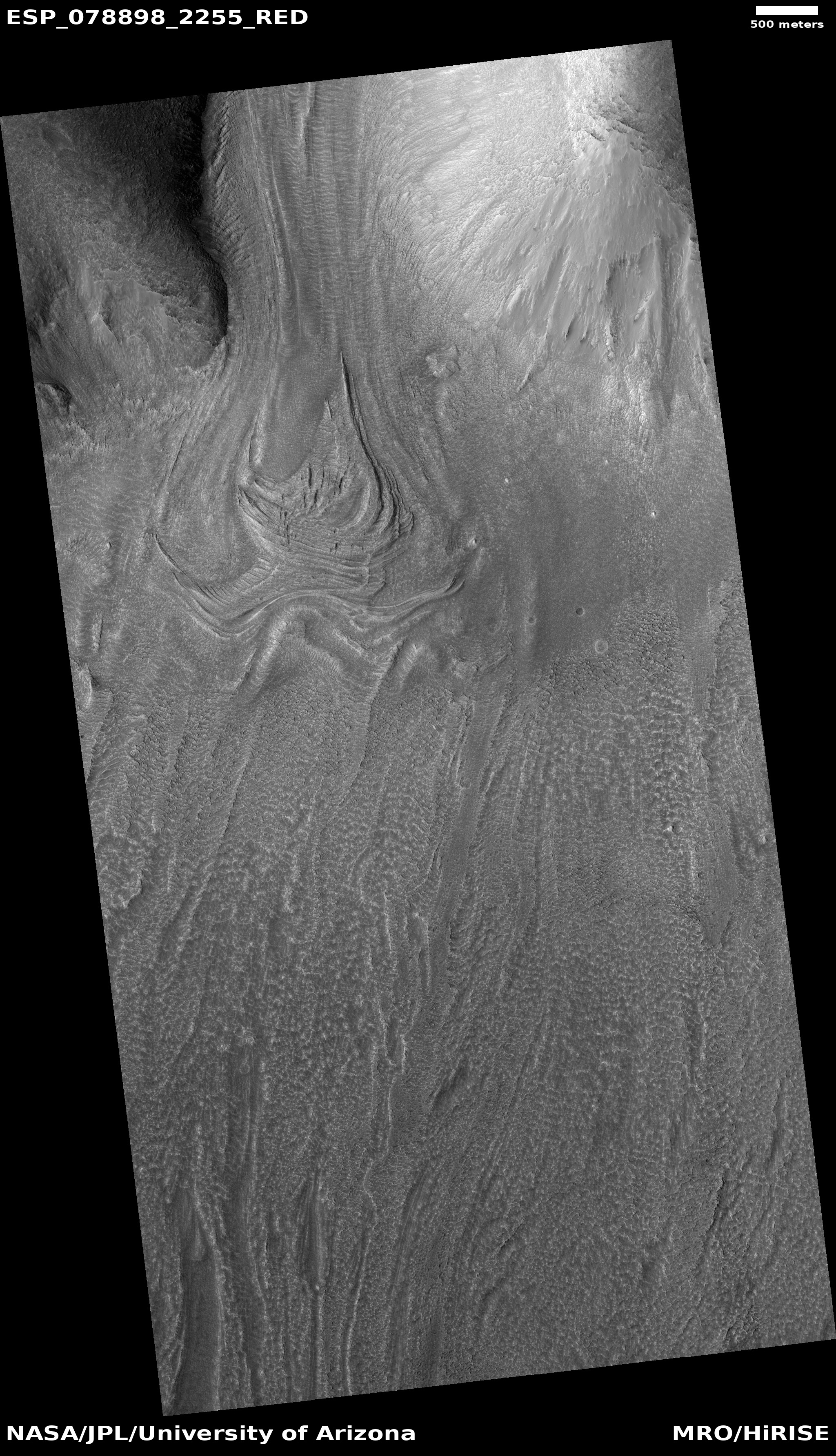
What the heck caused these cones to align on Mars?

Another
Click for original image.

Time for another “What the heck?” cool image! The picture to the right, cropped, reduced, and sharpened to post here, was taken on May 23, 2024 by the high resolution camera on Mars Reconnaissance Orbiter (MRO). It shows what the science team labels as “longitudinally aligned cones”.

To my eye the cones visibile in this picture seem more aligned latitudinally, to the east-west, instead of longitudinally, north-south, but the larger view in the inset on the overview map below shows that on a larger scale, the cones do appear aligned in a north-south direction.

Either way, this is one of those photos from Mars orbit that leaves me entirely baffled. The cones and the flow feature that cuts across the middle of the image might be either volcanic or glacial, but it is beyond my pay grade to explain what caused this patch of aligned cones.
» Read more

1 comment

Mining Mars

Mining Mars
Click for original image.

Cool image time! The picture to the right, cropped, reduced, and sharpened to post here, was taken on May 22, 2024 by the high resolution camera on Mars Reconnaissance Orbiter (MRO). The picture’s focus of study is the bright strip running diagonally across the center, which the scientists label as a “linear feature exposure of infrared-bright material.”

This bright strip with all the swirls of alternating light and dark terrain is a fissure about 80 feet deep. What is interesting is that the parallel bright features to the north and south are actually ridges, not depressions, even though there appears to be some resemblance between them all. (Note that the patches of very thin parallel lines are likely ripple dunes sitting on top of the topography.)

So, what created this fissure? And why is its inner surface so strange? As is usually the case, a wider look provides some clues.
» Read more

0 comments

Martian gullies flowing down to a Martian river of ice

Gullies on cliff wall
Click for original image.

Cool image time! The picture to the right, cropped, reduced, and sharpened to post here, was taken on May 16, 2024 by the high resolution camera on Mars Reconnaissance Orbiter (MRO).

The scientists label this as “gullies previously identified in the walls of Harmakhis Vallis.” The gullies are obvious, the series of erosion features on the cliff wall. The cliff itself drops about 2,800 feet from the rim to the floor, and also appears to have internal horizontal layers that the gullies cut through.

What causes the gullies? Planetary scientists have a number of theories, none of which appear to explain the gullies everywhere on the Martian surface. They all appear in the mid-latitudes, where the most glaciers on Mars are found, and appear to be related to ice or frost freeze-thaw processes, with some gullies actually very ancient and formed when the planet’s rotational tilt was significantly different.
» Read more

2 comments

Webb data suggests the possibility of ice and hydrated minerals on surface of Psyche

Using the Webb Space Telescope, astronomers have detected evidence of hydrated minerals and even possibly a very tiny amount of water ice on the surface of the metal asteroid Psyche.

The Webb data point to hydroxyl and perhaps water on Psyche’s surface. The hydrated minerals could result from external sources, including impactors. If the hydration is native or endogenous, then Psyche may have a different evolutionary history than current models suggest. “Asteroids are leftovers from the planetary formation process, so their compositions vary depending on where they formed in the solar nebula,” said SwRI’s Dr. Anicia Arredondo, another co-author. “Hydration that is endogenous could suggest that Psyche is not the remnant core of a protoplanet. Instead, it could suggest that Psyche originated beyond the ‘snow line,’ the minimum distance from the Sun where protoplanetary disc temperatures are low enough for volatile compounds to condense into solids, before migrating to the outer main belt.”

However, the paper found the variability in the strength of the hydration features across the observations implies a heterogeneous distribution of hydrated minerals. This variability suggests a complex surface history that could be explained by impacts from carbonaceous chondrite asteroids thought to be very hydrated.

You can read the research paper here [pdf]. The actual amount of water possible is at most 39 parts per million and is also an order of magnitude lower than that found on the Moon, which strongly suggests that it comes from outside sources, such as impacts from other asteroids, not from the inherent geological history of Psyche itself.

The uncertainties of this research, which are large, which should be resolved when the probe Psyche, launched last year, reaches the asteroid Psyche in August 2029.

3 comments

Buried peaks in a sea of Martian sand

Buried peaks in a sea of sand
Click for original image.

Cool image time! The picture to the right, rotated, cropped, reduced, and sharpened to post here, was taken on April 13, 2024 by the high resolution camera on Mars Reconnaissance Orbiter (MRO). It shows what the MRO science team labels as “streamlined features”, though that doesn’t seem to me to be the best description.

Granted, the prevailing winds, from the northeast to the southwest, appear to pushing the sand dune fields to the southwest. The dark line — created recently by a dust devil — indicates the wind direction. The mesas, from 100 to 200 feet high, do not however appear very streamlined. Instead, they simply look like they are poking up through this sea of sand and dunes, with the wind able over time to successfully push that sand uphill a hundred-plus feet into the saddle between the mesas.

The overview map below provides some context and possibly an explanation, though not a very conclusive one.
» Read more

0 comments

The strange carbon dioxide ice cap of Mars’ south pole

The strange carbon dioxide cap of Mars
Click for original image.

Cool image time! The picture to the right, cropped to post here, was taken on July 1, 2024 by the high resolution camera on Mars Reconnaissance Orbiter (MRO). The image is labeled simply as a “terrain sample,” which usually means it was taken not as part of any specific research project but to fill a gap in the picture-taking schedule in order to maintain the camera’s proper temperate. When the camera team needs to do this, they try to picture interesting features availabe at that time slot. Sometimes the image is boring. Sometimes it is surprisingly interesting.

In this case the picture is the latter, and certainly quite alien. The curly parallel dark lines appear to be grooves, and seem to have ripple dunes within them, as if the only dust here got trapped in those low spots. It is also possible that the dunes are frozen and ancient, and are only being revealed as the top layer in each groove goes away.

What could possibly explain what we are looking at? The overview map below gives only a clue.
» Read more

1 comment

A galaxy with a ring

A galaxy with a ring
Click for full image.

Cool image time! The photo to the right, cropped, reduced, and sharpened to post here, was taken by the Hubble Space Telescope, and appears part of a long term survey of nearby ringed galaxies. From the caption:

MCG+07-07-072 has quite an unusual shape, for a spiral galaxy, with thin arms emerging from the ends of its barred core to draw a near-circle around its disc. It is classified, using a common extension of the basic Hubble scheme, as an SBc(r) galaxy: the c denotes that its two spiral arms are loosely wound, each only performing a half-turn around the galaxy, and the (r) is for the ring-like structure they create. Rings in galaxies come in quite a few forms, from merely uncommon, to rare and astrophysically important!

Lenticular galaxies are a type that sit between elliptical and spiral galaxies. They feature a large disc, unlike an elliptical galaxy, but lack any spiral arms. Lenticular means lens-shaped, and these galaxies often feature ring-like shapes in their discs. Meanwhile, the classification of “ring galaxy” is reserved for peculiar galaxies with a round ring of gas and star formation, much like spiral arms look, but completely disconnected from the galactic nucleus – or even without any visible nucleus! They’re thought to be formed in galactic collisions.

This galaxy is about 320 million light years away, and is also known as Abell 426. Though astronomers think that these various shapes of galaxies, from barred to lenticular to ringed, are formed from a variety of galactic collusions and interactions with each galaxy’s nucleus, that remains nothing more than an educated guess. The complexity of galaxy evolution, involving billions of years and millions of stars, is barely in its infancy, and requires a lot of assumptions because our observations only involves a mere nanosecond in that grand history.

2 comments

Are these Martian terraced mesas or pits?

Are these Martian pits or mesas?
Click for original image.

Cool image time! The picture to the right, cropped, reduced, and enhanced to post here, was taken on July 2, 2024 by the high resolution camera on Mars Reconnaissance Orbiter (MRO). I have purposely enhanced the contrast to bring out the strangely shaped and terraced features.

What I cannot figure out from any data available to me is whether these terraced features are mesas rising up, or pits descending down. The resolution in the global mosiac of Mars created both from MRO’s context camera and its elevation data is simply not good enough. It suggests these are pits, but the sunlight is coming from the west, which based on the shadows suggest these could be pits or mesas.

In fact, the dark lines that appear to distinguish the terraces might not be shadows at all, but simply darker material that contrasts with the lighter material on each side.
» Read more

4 comments

Another “what the heck?” image from Mars

What the heck is this?
Click for original image.

Cool image time! The picture to the right, cropped, reduced, and sharpened to post here, was taken on April 14, 2024 by the high resolution camera on Mars Reconnaissance Orbiter (MRO), and shows what the scientists simply label as “exposed crater floor materials.”

I label it as another one of my “what the heck?” images, showing features that in some ways defy understanding or explanation. The picture shows a small area of the floor of an unnamed 14-mile-wide crater, with its rim indicated. Though clearly visible in orbital photos, the crater is nonetheless heavily eroded and even appears partly buried, possibly by flood lava.

The complex floor features however are not anything usually seen in flood lava terrains. The terrain colored blue in the color strip likely indicates coarse material like sand or rocks or rough bedrock, while the reddish terrain suggests the surface is heavily coated with dust.
» Read more

3 comments

A frozen bubbly caldron on Mars

A frozen bubbly caldron on Mars
Click for original image.

Cool image time! The picture to the right, rotated, cropped, reduced, and sharpened to post here, was taken on April 11, 2024 by the high resolution camera on Mars Reconnaissance Orbiter (MRO). It shows a nice collection of what the scientists label “irregular ring structures,” interspersed with clusters of small mesas ranging in heights from 13 to 75 feet.

The location is at 27 degrees north latitude, so the presence of near surface ice, which might explain these strange rings, is less likely though not impossible. The stipled nature of the flat ground suggests that near surface ice might be here, resulting in sublimation of that ice and leaving behind a flat but rough surface.

The location however suggests another possibility, which though vastly different in some ways, is almost identical in others.
» Read more

1 comment

Meandering Martian ridges flowing down from crater rim

Meandering Martian ridges
Click for original image.

Cool image time! The picture to the right, rotated, cropped, reduced, and enhanced to post here, was taken on February 9, 2024 by the high resolution camera on Mars Reconnaissance Orbiter (MRO). It shows a good example of the typically rough region inside the southern cratered highlands of Mars.

Note the ripple dunes that fill the low areas. The volcanic ash from Mars’ past volcanic history has become trapped here, with those ripple dunes suggesting the direction of the prevailing winds to the southeast.

The bright areas also suggest there is interesting mineralogy just below the surface. The 100-foot-high mesa near the picture’s top suggests a lot of erosion has occurred here, with its top suggesting the elevation of the surface a long time ago.

The most interesting feature however is the meandering ridge that starts at the lower right and weaves to the upper left.
» Read more

3 comments

Zebra layering in the Martian high southern latitudes

Zebra layering in the Martian high southern latitudes
Click for original image.

Cool image time! The picture to the right, rotated, cropped, reduced, and sharpened to post here, was taken on May 16, 2024 by the high resolution camera on Mars Reconnaissance Orbiter (MRO). The science team labeled it simple as a “terrain sample,” which usually indicates a picture not taken as part of any specific request or research project, but to fill a gap in the photography schedule in order to maintain the camera’s proper temperature.

When such pictures are necessary, the camera team tries to target the most interesting features that will be below MRO during the required time period. In this case they aimed for a north-facing slope, about 340 feet high, made up of a series of terraced layers, distinguished by the sharply contrasting bright flat benches and very dark cliff-faces.

While the cliffs are dark partly because of the sun is coming from the west, putting them in shadow, it is not entirely the cause. Note how the cliffs on the west side of the mound are also dark, suggesting that the darkness is a fundamental feature of the ground itself.
» Read more

0 comments
1 39 40 41 42 43 89