Cracks, chaos, and maybe caves in one place on Mars

Mosaic of Avernus Cavi fissures
Click for higher resolution. Original images found here and here.

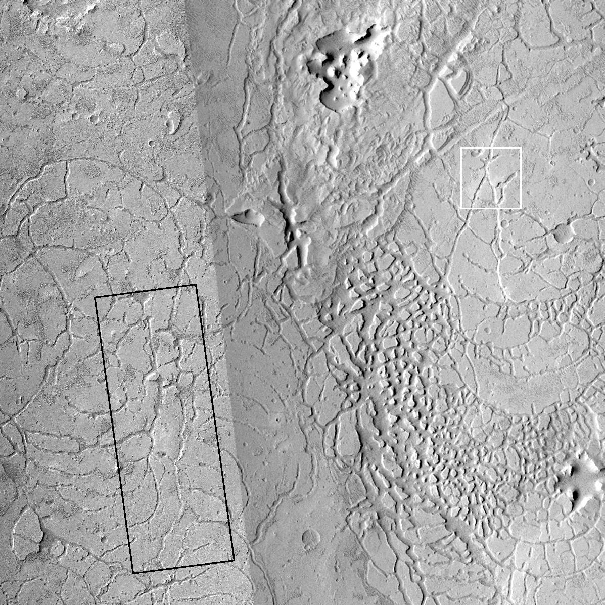
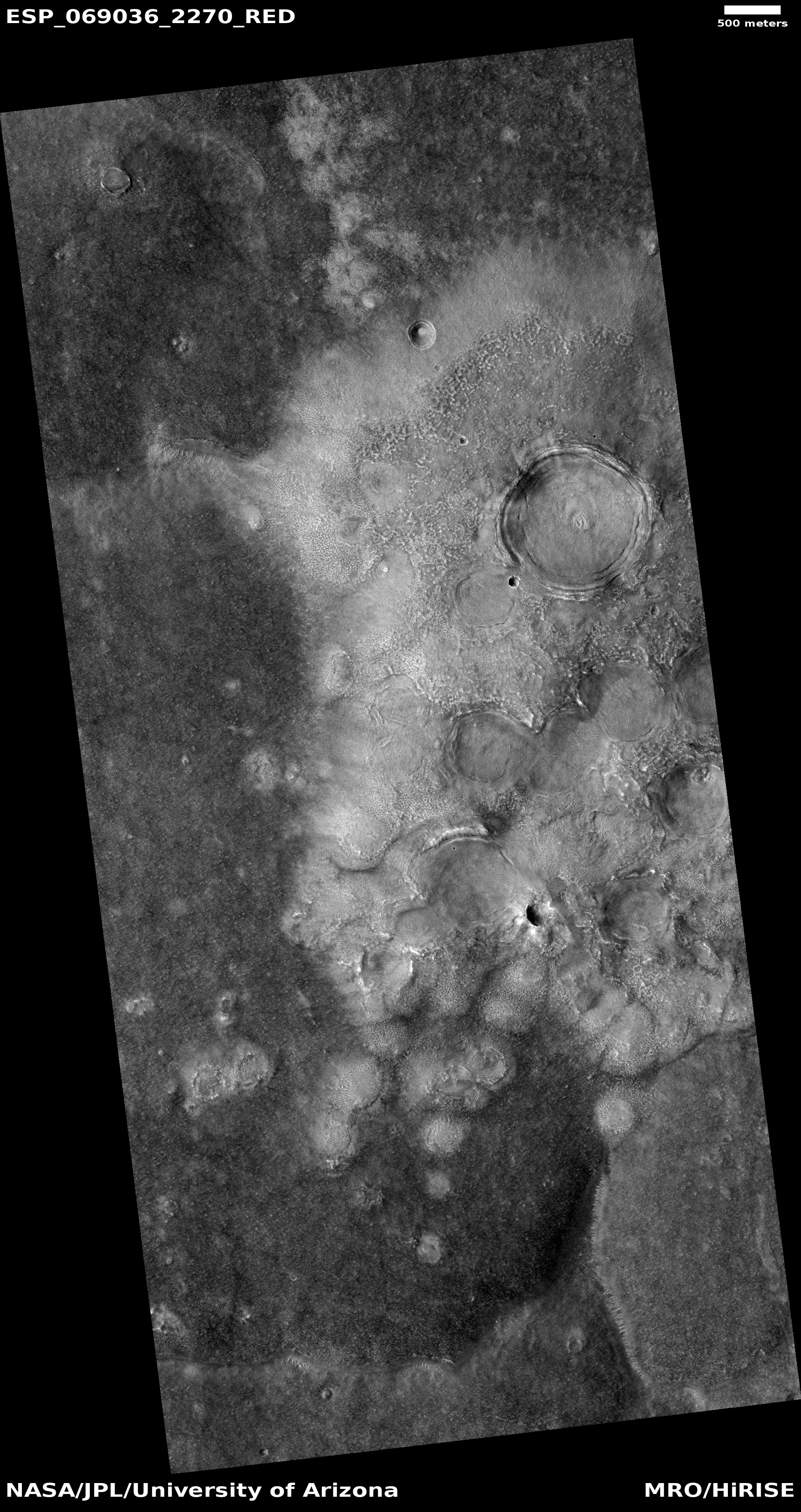
Today’s cool image to the right is a mosaic I have made from two images taken by the context camera on Mars Reconnaissance Orbiter (MRO), showing a most intriguing region on Mars dubbed Avernus Cavi, located in the large volcanic plain called Elysium Planitia between the giant volcanoes Elysium Mons and Olympus Mons, a region I like to call Mars’ volcano country.

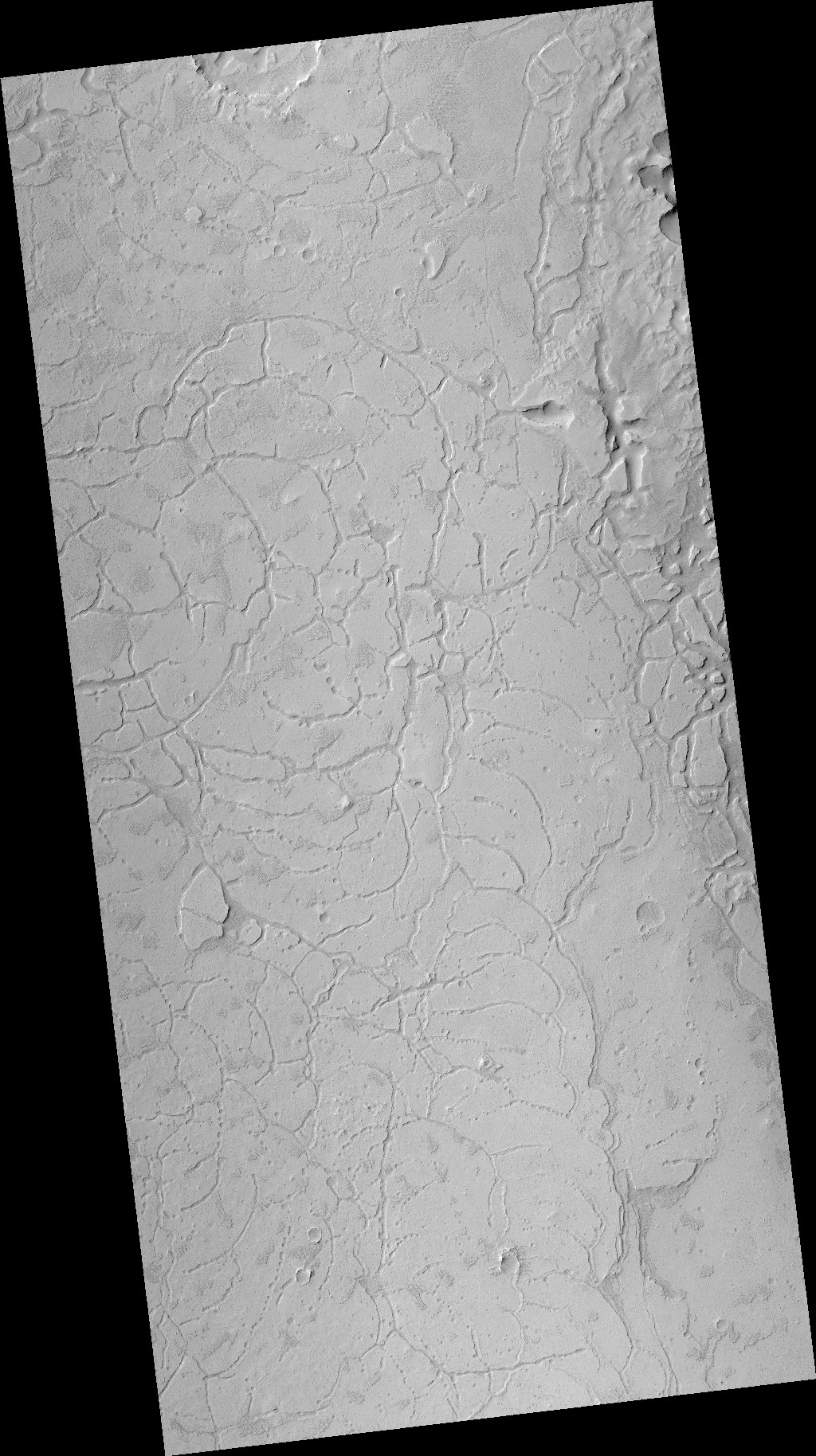
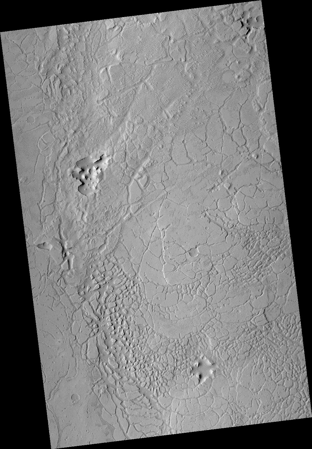
The mosaic shows in one picture much of the typical terrain in Avernus Cavi. We see many linear depressions or cracks, created when the ground stretched and cracked at weak points. We also see many depressions that suggest sinkholes, places where the surface sagged down because of a void below ground.

The area of knobs and mesas in the picture’s southeast quadrant is very typical Martian chaos terrain, the later result of long term erosion of these cracks and depressions.

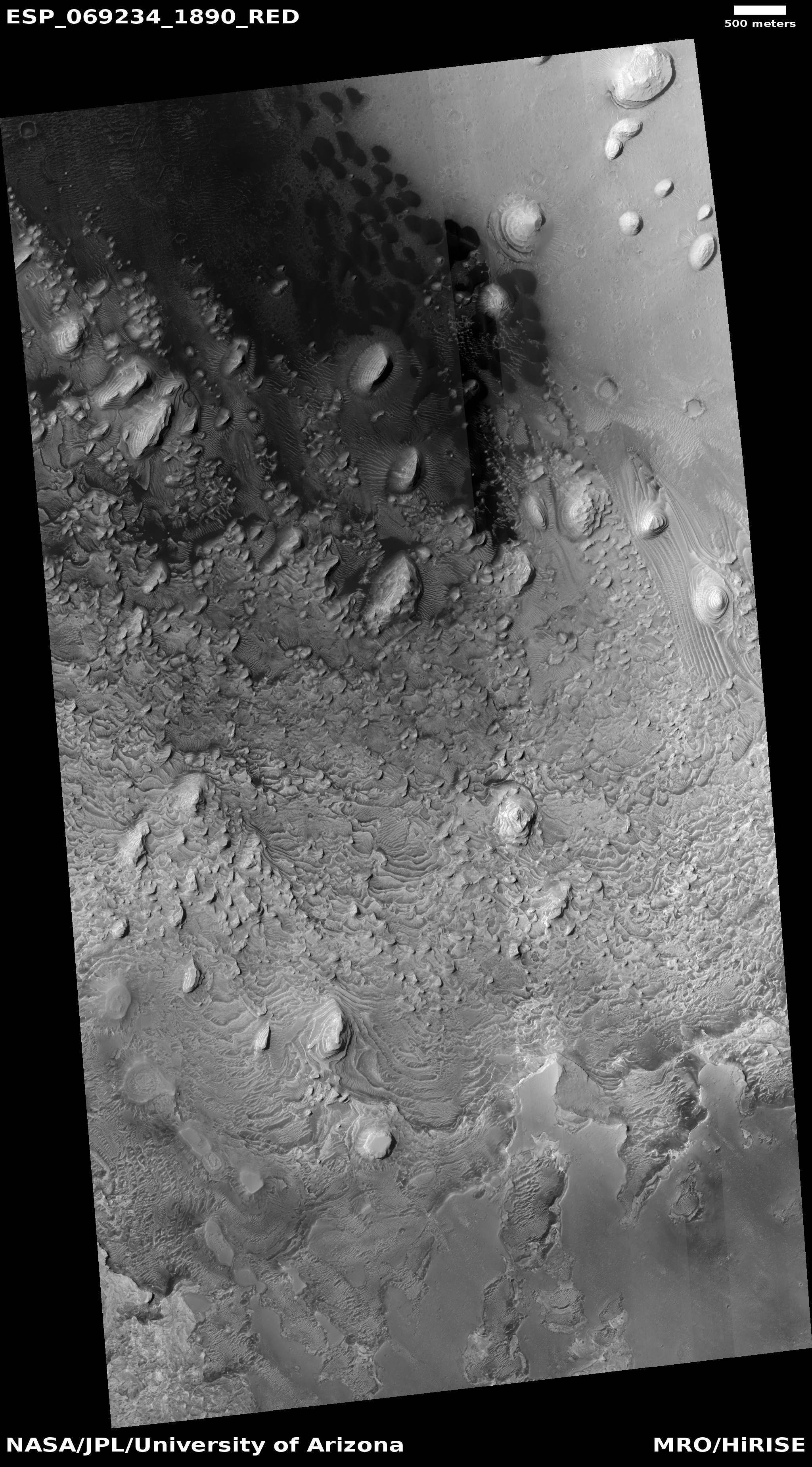
The white box shows the area covered by the image below.
» Read more

2 comments

First attempts to map the layered geology of Mars

layers in Jiji Crater on Mars
Click for full image.

Today’s cool image illustrates well the central task of much of today’s geological research on Mars, using the orbital images to try to map out the visible geological layers seen, and figure out if those layers mark over wide regions specific geological epochs, as they do on Earth.

The photo to the right, cropped and reduced to post here, was taken on May 4, 2021 by the high resolution camera on Mars Reconnaissance Orbiter (MRO), and featured on July 12th as a captioned image entitled “Layers Blanket a Crater Floor.” From the caption:

This image shows a layered rock formation within Jiji Crater that has eroded into buttes and stair-like layers.

This formation extends west and east. Similar layered rocks are within several craters in Arabia Terra and Meridiani Planum, including [nearby] Sera and Banes craters. The similarities suggest that the same process was forming deposits over a large geographic area long ago. Our image also indicates that much of the formation has eroded away relative to what has remained.

As you can see in the photo, the layers form a neat staircase of terraces descending from the south crater rim to the crater floor. They suggest that once the crater was filled with this material, which over time eroded away.

An image of similar layered buttes and mesas in Sera crater, only about 20 miles away, was featured here on Behind the Black in December 2020 The overview map below shows the relationship between Jiji, Sera, and Banes craters.
» Read more

0 comments

New images from Zhurong on Mars

Zhurong's view north
Click for full image.

China today released three new images from its Zhurong Mars rover, showing that since their last release in late June the rover has traveled about 1,000 feet to the south to reach the parachute and backshell (or entry capsule), both released just before landing.

The image to the right, cropped and reduced to post here, is the color panorama from that release, looking north. According to a translation of the Chinese press release, provided at this Space.com report, the image shows:

“The complete back cover structure after aerodynamic ablation, the attitude control engine diversion hole on the back cover is clearly identifiable,”

Below is an annotated orbital picture of this location taken by Mars Reconnaissance Orbiter (MRO) in mid-June.
» Read more

8 comments

Clashing layers in Mars’ largest canyon

Clashing layers on a mountain slope on Mars
Click for full image.

Cool image time! The photo to the right, rotated, cropped, and reduced to post here, was taken on May 27, 2021 by the high resolution camera on Mars Reconnaissance Orbiter (MRO), and shows the clash of different layers on the western slope of a mountain within Mars’ largest canyon, Valles Marineris.

The scientist have labeled this a “possible angular unconformity.” In geology an unconformity generally refers to a gap in a series of layers, a period when instead of the layers being deposited they are being eroded away, leaving no record for that time period. An angular unconformity adds tilting to the older layers, which after erosion are then covered by new layers that are oriented somewhat differently.

Based on these definitions, what the scientists suspect is that the brighter layers to the left and lower down the mountain are older. After a period of erosion new layers were deposited on top at a different angle, forming the stripe of layers going from center left up to center right.

The swirly nature of the material on the top of the ridge suggests to me that these layers might be volcanic in nature, but that’s a pure uneducated guess. What some scientists do believe (but have not yet conclusively proven) is that the lower older layers are sediments laid down by an ancient lake that once filled the canyon here.

The overview map below provides a wider view and some context.
» Read more

1 comment

Springtime on Martian dunes near the north pole

Dunes near the Martian north pole, in the spring

Cool image time! The photo to the right, rotated and cropped to post here, was taken by the high resolution camera on Mars Reconnaissance Orbiter (MRO) on April 27, 2021. It shows a strange scattering of dunes on a flat plain. The red at the top of each dune probably indicates exposed dust and sand. The white fringe is likely either water frost or the leftover mantle of dry ice that is deposited in the polar regions each winter down to 60 degrees latitude, and disappears with the coming of spring, sublimating back into carbon dioxide gas.

There are a lot of puzzles here. The overview map below provides some context, but only some.
» Read more

0 comments

Sublimating scallops on Mars

Giant scallop on Mars
Click for full image.

Today’s cool image, shown in a rotated, cropped, and reduced version to the right, gives us a close-up look at one of the giant scallops found in the high mid-latitudes of the northern lowland plains of Mars, specifically in Utopia Basin north of the landing sites of both Perseverance and Zhurong. In fact, this particular image is only a few miles north of one of my previous cool images, Giant scallops on Mars, posted in December 2019.

The image was taken on February 3, 2021 by the high resolution camera on Mars Reconnaissance Orbiter (MRO). While such scallops are not unusual in the mid-latitudes, their formation process is not well understood. As I noted in the 2019 post, ” scientists believe [pdf] the formation process is related to the sublimation of underground ice.”

According to [one hypothesis] scallop formation should be ongoing at the present time. Sublimation of interstitial ice could induce a collapse of material, initially as a small pit, then growing [away from the equator] because of greater solar heating on [that] side. Nearby scallops would coalesce together as can be seen to have occurred.

This hypothesis is not proven, and today’s cool image raises questions about it. Though the bright material at its center suggests exposed ice, supporting the idea that sublimation of ice near the surface created the scallop, the scallop scarps seem more extended and distinct to the south, not the north as this hypothesis proposes. Sunlight should hit the northern scarps more, which suggests they should retreat more instead of the southern scarp.

The overview map below provides the context.
» Read more

1 comment

Paisley terrain on Mars

paisley terrain on Mars
Click for full image.

Cool image time! The photo to the right, cropped and reduced to post here, is actually a somewhat old image from the high resolution camera on Mars Reconnaissance Orbiter (MRO). It was taken more than a decade ago, on December 28, 2010, and featured as a captioned image one month later. I post it now because it was recently featured as MRO’s picture of the day, and thought it deserved a new look. As the caption from 2010, written by planetary scientist Alfred McEwen, noted,

Remember those paisley shirts during the summer of love in 1967? If so, this terrain may look somewhat familiar.

How did this terrain really form? One theory is that it’s a landslide deposit, perhaps associated with draining an ancient lake.

The overview map below might help make sense of this theory.
» Read more

1 comment

Many of Mars’ geological mysteries, all in one photo

Knobs, streaks, and lava channels on Mars
Click for full image.

Today’s cool image is fun because it contains a plethora of Martian mysteries, all packed into a very small space. The photo to the right was taken on April 29, 2021 by the high resolution camera on Mars Reconnaissance Orbiter (MRO). I have rotated, cropped, and reduced it to post here.

The uncaptioned picture was labeled “Small Channel Winding between Knobs in Tartarus Colles.” The knobs, which can be seen on either side of the thin channel within the canyon, are actually a major Martian puzzle. Tartarus Colles has a lot of them, and planetary geologists are not really sure how they formed. One 2009 paper [pdf] suggested that the cones were formed by the violent interaction of lava and ice. This earlier paper [pdf] hypothesized that both water and lava had to be flowing over the surface at the same time, producing the steam and the energy that popped the lava cones, kind of like the small convection bubbles seen when tomato sauce simmers.

The scientific literature however is not deep, and there appears to be much uncertainty about this conclusion.

The photo however contains other major Martian puzzles.
» Read more

0 comments

Zhurong’s travels during first three weeks on Mars

Zhurong's travels through June 11th
Click for full image.

The science team for the high resolution camera on Mars Reconnaissance Orbiter (MRO) today released a new image showing the path that China’s rover , Zhurong, has taken from its landing on May 14th through June 11th.

The photo to the right, cropped and reduced to post here, is that photo. If you look close you can see the rover’s track skirting the edge of the bright blast mark put on the surface by the lander’s engines during touchdown. Though my scale bar is approximate, it does show that in those four weeks the rover traveled about 150 to 200 feet. However, half of that distance was crossed in the five days from June 6th to June 11th (as shown by the two different MRO images at these links), which means the pace is picking up.

The rover’s nominal three-month mission ends in mid-August, only two months from now. However, none of us should be surprised if the mission gets extended for as long as the rover continues to function.

2 comments

A sample of typical but strange Martian northern lowland plain geology

Typical lowland features on Mars
Click for full image.

Cool image time! The photo to the right, rotated, cropped and reduced to post here, was taken on April 18, 2021 by the high resolution camera on Mars Reconnaissance Orbiter (MRO). It shows a nice sample of the typical glacial-filled craters found often in the mid-latitudes between 30 to 60 degree latitudes, surrounded by a lot of erosion features representative of these lowland northern plains.

The biggest crater is very symptomatic of what scientists have dubbed concentric crater fill, a feature that they believe reveals that there is buried ice water glaciers here, protected by a thin layer of debris. The apron of brighter material surrounding the crater could be a splash feature created during impact and now more obvious because it has been revealed as sublimation and erosion lowered the terrain nearby.

The location is north of the Cydonia region in Acidalia Planitia, several thousand miles to the northeast of the region where Viking 1 landed in 1976 and Mars Pathfinder landed in 1997, as shown in the overview map below.
» Read more

0 comments

A confused river of ice on Mars

A river of ice on Mars
Click for full image.

Cool image time! The photo to the right, rotated, cropped, and reduced to post here, was taken on March 4, 2021 by the high resolution camera on Mars Reconnaissance Orbiter (MRO). It shows what MRO’s science team labeled a “Landform in Source Region of Harmakhis Vallis.”

They are being very correct and careful with that label. The landform here is quite clearly reminiscent of a glacier, but because they don’t yet have confirmation of its watery nature, as good scientists they can’t call it that.

I however am a mere journalist, so I am free to speculate more wildly. Sure looks like glaciers to me, the ice flowing downhill from the left to the right and flowing around that central mound.

The overview map below gives a wider context, but also makes the behavior of the glaciers here far more puzzling.
» Read more

19 comments

Boxwork in the basement of Mars

Polygon ridges in Hellas Basin
Click for full image.

Cool image time! The photo to the right, rotated, cropped, and reduced to post here, shows what resembles closely what in Earth caves are called boxwork, polygonal ridges sticking out from the bedrock and usually indicating cracks filled with harder material that resist erosion.

Taken by the high resolution camera on Mars Reconnaissance Orbiter (MRO) on March 23, 2021, what makes this boxwork especially interesting is its size and location. On Earth cave boxwork generally ranges from a few inches to a few feet across. Not only do these Martian ridges range from 100 feet to a half mile in length, they are located at the lowest point in Hellas Basin, the basement of Mars. In fact, this spot is as close as you can get to Mars’ Death Valley, as shown by the overview map below.
» Read more

3 comments
1 54 55 56 57 58 90