
Mars Reconnaissance Orbiter has now resumed full science operations after it went into safe mode late last week.
Mars Reconnaissance Orbiter has now resumed full science operations after it went into safe mode late last week.
Mars Reconnaissance Orbiter has now resumed full science operations after it went into safe mode late last week.
Mars Reconnaissance Orbiter entered safe mode on Friday, caused by unexpected switch to a backup computer.
They expect to get the probe back into full operation in a couple of days.

The image on the right is a cropped close-up of a Mars Reconnaissance Orbiter image taken in early September that shows a fresh cluster of impacts, all smaller than six feet across. Nearby but not visible in this image are four larger craters about 12 to 15 feet in diameter. The impact cluster is located just northwest of Gale Crater and was not present in images taken before Curiosity’s arrival on Mars. The cluster is also in line with other impact craters produced by other debris dropped by Curiosity as it descended onto the Martian surface.
Scientists are at the moment unsure what spacecraft debris caused these impacts.
Assigning each of the impacts to specific pieces of hardware is a challenging puzzle, but it is thought that the four large craters were produced by two large tungsten weights that broke in half to make these four craters, or by pieces of the cruise stage, which was designed to break up in the atmosphere for planetary protection purposes, to kill any Earthly microbes.
The cluster imaged here adds to the mystery, and may have been produced by a piece of the cruise stage that traveled farther through the Martian atmosphere and was therefore more thoroughly fragmented by the time it crashed onto the surface.
Identifying the source of the debris is a challenging engineering problem that also has scientific interest. Knowing what caused the impacts and then studying how the surface was changed by them will tell geologists a great deal about the make up of that surface.
A collection of new images from Mars by a variety of spacecraft and rovers.
Posted as we approach El Paso and the Texas-New Mexico border.
In celebration of the 10th anniversary of the launch of Opportunity, Mars Reconnaissance Orbiter took its photograph.
The image was not merely for PR. It also provides the scientists operating Opportunity some good information about the region the rover is exploring, thus helping them plan out its further adventures on the surface of Mars.
Curiosity is out of safe mode and will be resuming full science operations by next week.
It is imperative that the engineers clear up these computer problems now, as communications with the rover will be limited in April because the sun will be in the way.
Transmissions from Earth to the orbiters [Mars Odyssey and Mars Reconnaissance Orbiter] will be suspended while Mars and the sun are two degrees or less apart in the sky, from April 9 to 26, with restricted commanding during additional days before and after. Both orbiters will continue science observations on a reduced basis compared to usual operations. Both will receive and record data from the rovers. Odyssey will continue transmissions Earthward throughout April, although engineers anticipate some data dropouts, and the recorded data will be retransmitted later.
The Mars Reconnaissance Orbiter will go into a record-only mode on April 4. “For the entire conjunction period, we’ll just be storing data on board,” said Deputy Mission Manager Reid Thomas of JPL. He anticipates that the orbiter could have about 40 gigabits of data from its own science instruments and about 12 gigabits of data from Curiosity accumulated for sending to Earth around May 1.
NASA’s Mars Exploration Rover Opportunity is approaching its fifth solar conjunction. Its team will send no commands between April 9 and April 26. The rover will continue science activities using a long-term set of commands to be sent beforehand.
Volunteers are needed to analyze images from Mars. From the website:
We need your help to find and mark ‘fans’ and ‘blotches’ on the Martian surface. Scientists believe that these features indicate wind direction and speed. By tracking ‘fans’ and ‘blotches’ over the course of several Martian years to see how they form, evolve, disappear and reform, we can help planetary scientists better understand Mars’ climate. We also hope to find out if these features form in the same spot each year and also learn how they change.
The Mars Reconnaissance Orbiter team today released a set of images showing Curiosity’s first steps on Mars, as well as some fascinating closeups of the spacecraft’s heat shield, parachute, and descent stage. The image on the left shows the tracks of the rover during its first few days of travel.
Mars Reconnaissance Orbiter last night captured a spectacular image of Curiosity descending by parachute to the surface of Mars.
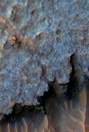
The uncertainty of science: In this week’s release of images from Mars Reconnaissance Orbiter, the science team posted the image on the right and asked, “What is this stuff?”
Here’s a hypothetical geologic history that might explain this scene: layered sediments were deposited by water or airfall (including volcanic pyroclastics). A crudely polygonal patterned ground was created by stresses in the sediments, and groundwater followed the fractures and deposited minerals that cemented the sediments. This was followed by perhaps billions of years of erosion by the wind, leaving the cemented fractures as high-standing ridges.
Of course, this story is almost certainly incomplete if not totally wrong.
Click here to see the close-up subimage from which I cropped the image on the right.
Mars Reconnaissance Orbiter today released an image of a really spectacular transform fault on Mars, a spot where the ground cracked and two sections moved sideways to each other. In this case, the sideways movement was about 300 feet. The image is posted below the fold.
Compare that with the Japanese magnitude 9 earthquake on March 11, which only shifted the seabed sideways 165 feet while raising it 33 feet. The quake that moved these two pieces of Martian bedrock sideways must have been quite a ride.
» Read more
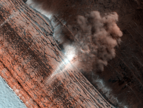
The Mars Reconnaissance Orbiter team today released this really cool image from Mars, showing an avalanche near the North Pole, in progress. The image looks directly down the cliff face from above. At the base of the cliff we can see the dust cloud from the crash of material billowing out away from the scarp.
What impresses me most about this image is that it was taken by an orbiting spacecraft approximately 200 miles above the planet’s surface, moving at thousands of miles an hour. Yet, the camera not only had the resolution to see the cloud of dust, it could snap the image fast enough to capture the actual fall of material (the white wisps down the side of the cliff that are reminiscent of a waterfall).
Also intriguing is the visible steep face of the cliff face itself. I know a lot of rock climbers who would love to literally get their hands (and chocks) on that rock face. And in Mars’s one-third gravity, rock climbing would surely be different.
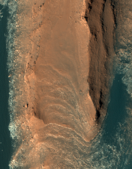
Last week the Mars Reconnaissance Orbiter team released this beautiful image of what they call “layered yardangs” on Mars.
What creates these sharp ridges? This layered terrain has been sculpted by the wind. The aligned ridges are called yardangs, which are formed in areas where the dominant erosional force is the wind. Yardangs are also found on Earth, usually in very dry areas.
What I see are majestic red cliffs rising out of a aqua-colored sand desert. What a place to visit!
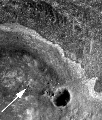
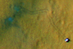
The image to the right was taken by Mars Reconnaissance Orbiter, with the white arrow showing the Mars rover Opportunity perched on the rim of Endeavour Crater.
The rover’s scientists hope that the rocks found on the crater rim, dredged up from deep below when the crater impact occurred, will be the oldest rocks so far touched on the Martian surface, and thus give them a peek at ancient Martian geology.
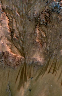
More evidence that there are active flows of water on Mars.
Dark, finger-like features appear and extend down some Martian slopes during late spring through summer, fade in winter, and return during the next spring. Repeated observations have tracked the seasonal changes in these recurring features on several steep slopes in the middle latitudes of Mars’ southern hemisphere.
Though there are a number of unsolved issues about these features, the best explanation appears to be a liquid brine.
Saltiness lowers the freezing temperature of water. Sites with active flows get warm enough, even in the shallow subsurface, to sustain liquid water that is about as salty as Earth’s oceans, while pure water would freeze at the observed temperatures.
Go here to see the full image.