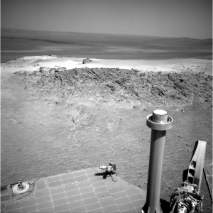
Rover update: Curiosity’s future journey

Mount Sharp, with Curiosity's future travels
Click for full image.

[For the overall context of Curiosity’s travels, see my March 2016 post, Pinpointing Curiosity’s location in Gale Crater. For the updates in 2018 go here. For a full list of updates before February 8, 2018, go here.]

Today the science team of Curiosity issued a press release outlining their travel plans for the rover over the next year. In conjunction, they also released a mosaic of 116 images taken by the rover showing that route, a reduced in resolution version shown above.

The rover’s next stop is a part of the mountain called the “sulfate-bearing unit.” Sulfates, like gypsum and Epsom salts, usually form around water as it evaporates, and they are yet another clue to how the climate and prospects for life changed nearly 3 billion years ago.

But between the rover and those sulfates lies a vast patch of sand that Curiosity must drive around to avoid getting stuck. Hence the mile-long road trip: Rover planners, who are commanding Curiosity from home rather than their offices at NASA’s Jet Propulsion Laboratory in Southern California, expect to reach the area in early fall, although the science team could decide to stop along the way to drill a sample or study any surprises they come across.

Overview map sol 2804 of Curiosity's route

This journey actually began in late May, at about the time of my last rover update. The overview map to the right shows in red their approximate planned route to avoid that large dune field to the south. The meandering yellow line indicates Curiosity’s actual route. The straight yellow lines indicates I think the area covered by the mosaic above. As you can see, since the end of May they have quickly returned to their planned route. Note also that the dune field extends about twice the distance beyond the eastern edge of this overview map.

The next big goal when they reach that sulfate-bearing unit will be to not only study it but to also study a recurring slope lineae on the slopes of that unit, a streak that darkens and lightens seasonally that might be caused by seeping brine from below. Because the sulfate unit and the linneae are both major geological goals, they are going to be moving fast to get there. I am sure they will periodically stop to do geology, but I think the travel will be, as it has been for the past month, quick-paced.

Once the rover gets to the sulfate unit, Curiosity will at last have actually reached the base of Mount Sharp. Up until now it has been traveling first in the surrounding plains, then in the mountain’s foothills. The terrain will get much rougher and be far more spectacular, as Curiosity will be entering canyons as it begins to climb the mountain itself.

1 comment

A hanging crater on Mars

Hanging crater
Click for full image.

Overview

Cool image time! The image to the right, cropped and reduced to post here, was taken by Mars Reconnaissance Orbiter (MRO) on May 1, 2020, and shows a truly intriguing crater that they dub a “Crater Hanging on Mesa Wall.”

Located in Deuteronilus Mensae, a chaos region of mesas and cross-crossing canyons in the transition zone between the northern lowland plains and the southern cratered highlands, the crater literally overhangs the edge of this canyon’s cliff. The overview map to the right, with this location indicated by the red box, illustrates what this region’s geology is like.

The most likely explanation is that the impact occurred prior to the creation of the canyon, and when the canyon eroded, the material in and of this crater was more resistant, probably because the impact had packed it together to increase its density.

At the same time, the features inside both craters in the photo, as well as below them on the floor of the canyon, suggest the presence of buried glaciers, something not unlikely at the 45 degree north latitude where this crater sits.

So, here’s a guess at the geological history. First we had the impact, then during the eons of glacial ebb and flow on Mars due to wide swings in the planet’s obliquity (its rotational tilt), the canyon was cut, with that erosion leaving the crater sitting high above the canyon floor below it.

One more curious detail: The material in the canyon seems asymmetric, suggesting that the crater actually dips down toward the canyon, as if it as a unit has tilted to the east as the canyon was worn out below it.

1 comment

China announces target launch date for its Tianwen-1 Mars rover

The new colonial movement: According to a new report out of Singapore, China has set July 20-25 as the launch window for its Mars orbiter/lander/rover mission, dubbed Tianwen-1.

Should they meet this date, it means they will launch before Perseverance, arriving at Mars about the same time, in February 2021. And like Perseverance, this launch window closes this summer, and if they can’t meet it they will have to wait two years.

5 comments

Perseverance launch delayed to July 30, 2020

Not good: Because of an issue with the Atlas 5 rocket, NASA and ULA have decided to delay again the launch of the next Mars rover Perseverance from July 22nd to July 30th.

“Due to launch vehicle processing delays in preparation for spacecraft mate operations, NASA and United Launch Alliance have moved the first launch attempt of the Mars 2020 mission to no earlier than July 30,” NASA said. “A liquid oxygen sensor line presented off-nominal data during the Wet Dress Rehearsal, and additional time is needed for the team to inspect and evaluate.”

ULA performed the Wet Dress Rehearsal on June 22. The exercise involved rolling the Perseverance rover’s Atlas 5 launcher out of its vertical integration hangar to Cape Canaveral’s Complex 41 launch pad, then loading the rocket with kerosene, liquid hydrogen, and liquid oxygen propellants. The launch team practiced countdown procedures, testing the Atlas 5’s systems before halting the pre-launch sequence seconds before ignition of the rocket’s RD-180 main engine.

Their official launch window extends to August 11th, though they could still launch as late as August 15th and get to their landing site in Jezero Crater on Mars.

This is the third delay. The first involved a faulty crane and the second contamination issues in the rover’s clean room. Now an issue with an oxygen sensor. Let us hope their are no more, and that the weather then cooperates. It they don’t launch by August 15th the launch will then be postponed for two whole years.

1 comment

Perseverance launch delayed two days

NASA and ULA have agreed to delay the launch of the new Mars rover Perseverance two days, from July 20th to July 22nd, because of “a contamination concern.”

NASA’s Mars rover Perseverance was scheduled to launch toward the Red Planet on July 20 from a pad at the Cape Canaveral Air Force Station in Florida. But a problem cropped up as engineers worked to encapsulate the rover in the nosecone of its Atlas V rocket, which was built by United Launch Alliance.

“NASA and United Launch Alliance are now targeting Wednesday, July 22, for launch of the Mars 2020 mission due to a processing delay encountered during encapsulation activities of the spacecraft,” NASA officials said in an update. “Additional time was needed to resolve a contamination concern in the ground support lines in NASA’s Payload Hazardous Servicing Facility (PHSF).”

This contamination likely relates to their effort to keep the rover free from Earth biology.

The official launch window closes on August 11th, though they can still launch as late as August 15th and get to their targeted landing site in Jezero Crater on Mars.

0 comments

More strange terrain in the Martian “Death Valley”

More strange terrain in Hellas Basin
Click for full image.

Today’s cool image, rotated cropped, and reduced to post here, might show what the science team for the high resolution camera of Mars Reconnaissance Orbiter (MRO) have labeled “strange banded terrain”, but anyone who has spent any time perusing images of Hellas Basin, what I have labeled the basement of Mars because it has the lowest elevation on the planet, will recognize the features.

They might be inexplicable, but for Hellas Basin they are entirely familiar. Just take a look at some of my earlier posts:
» Read more

0 comments

Perseverance: update on launch rehearsal and helicopter

Two news stories today about the launch of the United States’ next Mars rover, Perservance.

First, ULA yesterday successfully completed a dress rehearsal countdown with the Atlas 5 rocket that will launch Perseverance on July 20 at 9:15 am (Eastern)..

The rover will be mounted onto the rocket at the end of this week.

Second, JPL provided this press release describing how Perseverance’s test helicopter Ingenuity will be deployed on the Martian surface, where it will then test to see if such helicopters will work in the Martian atmosphere.

Sixty Martian days (dubbed sols) after landing in Jezero Crater on February 18, Perseverance will find a nice large flat area and deploy the helicopter six sols later. The helicopter will then begin its 30-sol test program. If it is found to work, future rovers will almost certainly be equipped with such helicopters, acting as scouts able to go places the rover cannot.

5 comments

Enigmatic layering and chasms on Mars

Enigmatic layering and chasms
Click for full image.

Overview map

Cool image time! The photo to the right, rotated, cropped, and reduced to post here, was taken on April 28, 2020 by the high resolution camera on Mars Reconnaissance Orbiter. (MRO). The science team entitled it “Enigmatic Uplifts in Echus Montes,” indicating a sense of bafflement on their part about this geology.

The features here are certainly somewhat puzzling. At first glance the terrain is reminiscent of Martian chaos terrain, mesas cut by canyons in an almost random pattern. As I explained at the link,

Chaos terrain is typically a collection of mesas separated by straight-lined canyons. It is found in many places on Mars, most often in the transition zone between the southern highlands and the northern lowlands where an intermittent ocean might once have existed. It is believed to form by erosion, possibly caused by either flowing water or ice, moving along fault lines. As the erosion widened the faults, they turned into canyons separating closely packed mesas. With time, the canyons widened and the mesas turned into a collection of hills.

What makes this particular image puzzling however is that there seem to be multiple layers of mesas and canyons. Look at the top of the rectangular mesa in the upper middle of the image. It appears to have its own miniature chaos terrain on its plateau. Somehow that first layer of chaos was abandoned when the more prominent larger canyons started to form around it.

The location of this feature is indicated by the black cross on the overview map to the right. It is in the middle of the large and wide northward trending part of the giant valley dubbed Kasei Valles. And as usual, knowing the location helps explain what we are seeing.
» Read more

2 comments

Trace Gas Orbiter detects oxygen layer in Martian atmosphere

Europe’s Trace Gas Orbiter, in orbit around Mars, has detected for the first time the green atmospheric layer in Martian atmosphere caused by the interaction of oxygen and sunlight.

From what I can tell from the press release at the link, they did not “see” this green glow, they detected it spectroscopically. So, any images you see portraying it are simply artist renditions, not the real thing.

The detection is important, nonetheless. First, it confirms that there is oxygen in Mars’ atmosphere. Second, it is the first time this has been detected in the atmosphere other than Earth. Third, the detection matched closely to their computer models, suggesting that the models are a reasonable simulation of this aspect of Mars’ atmosphere.

1 comment

Deciphering the strange geology of Mars — or anything!

Eroding Medusae Fossae Formation ash deposits
Click for full image.

Today’s cool image is for once not taken by the high resolution camera on Mars Reconnaissance Orbiter (MRO). Instead, the image to the right, cropped and reduced to post here, was taken by Mars Odyssey on April 5, 2020, and shows the scouring and erosion caused by winds over many eons in a region dubbed Zephyria Planum. (Note that the image might fool your eye. Sunlight is coming from the east, and the rough terrain at the top is higher than the smooth plain at the bottom.)

Years ago, when I first started to rummage through the archives of images from the various Mars orbiters, I would have seen this image and posted it because I was completely baffled by what I saw, and thought that mystery made it worth showing to the public. Since then my incessant probing of research papers as well as asking a lot of questions of scientists has taught me a lot more about what scientists now surmise of the Martian geology. This greater knowledge in turn makes it possible for me to look at an image like this and immediately make a reasonable guess as to an explanation. This photo, while still containing much that is mysterious, is no longer completely baffling to me.

This willingness to ask questions and dig deeper is fundamental to all things. To have a deeper understanding and not simply guess about any subject, you always have to recognize that your assumptions are likely wrong, and that to learn anything you have to repeatedly ask what I call “the next question.” The first answer will force you to recognize that your first guesses are wrong, raise more questions, which in turn will lead to more questions, and then more questions, and so forth.

Whether I am researching Mars or early space history or politics, this rule always applies. Don’t leap to a conclusion. Think it possible you could be wrong. Ask the next question. And the next. You will repeatedly find that what you thought you knew was not correct, and in the end you will gain a deeper understanding of what is actually known about any subject, as well as what is unknown. And knowing the unknowns is probably the most important thing you can learn.

To gain a better understanding of today’s particular image, our first questions must start with context. Where is this feature on Mars? What is the surrounding history of that location? And what is already known about this place?

The location immediately reveals a great deal, as shown in the overview map below.
» Read more

4 comments

Help scientists plan Curiosity’s future travels

The Curiosity science team is asking the help of ordinary citizens in improving the software it uses to plan Curiosity’s future travels.

Using the online tool AI4Mars to label terrain features in pictures downloaded from the Red Planet, you can train an artificial intelligence algorithm to automatically read the landscape.

Is that a big rock to the left? Could it be sand? Or maybe it’s nice, flat bedrock. AI4Mars, which is hosted on the citizen science website Zooniverse, lets you draw boundaries around terrain and choose one of four labels. Those labels are key to sharpening the Martian terrain-classification algorithm called SPOC (Soil Property and Object Classification).

The goal is not to have citizens plan the rover’s route, but to use their judgments to refine the software that the scientists and engineers use to plan the route. This refinement will also be applicable to Perseverance when it gets to Jezero Crater in February 2021.

0 comments

Isidis Basin, on whose margin Perseverance will roam

Pedestal craters in Isidis Basin
Click for full image.

Overview map

Today’s cool image to the right, cropped and reduced to post here, highlights the floor of one of Mars’ largest basins, dubbed Isidis Planitia, and located at the transition zone between the planet’s northern lowland plains and the southern cratered highlands.

The overview map below of Isidis Basin provides some context. The white box shows where this particular image is located. Jezero Crater, indicated by the red circle (which is also about the size of the crater), is where the rover Perseverance is going to land and roam come February 2021, should all go well. For scale, Isidis is about the size of the eastern half of the United States. If Chicago was located at Jezero Crater, Baltimore would be on the basin’s eastern edge, at around 4 o’clock.

This particular section of the full photo, taken on April 5, 2020 by the high resolution camera on Mars Reconnaissance Orbiter (MRO), shows many features very typical of the floor of Isidis Basin, which also immediately reveal a great deal about its possible history.

In this small snippet we can see what at first glance appear to be pedestal craters standing up like mesas, with ordinary craters scattered about on that lower surrounding terrain. Clearly, if these are pedestal craters they had to have been created first, and then over a very long time erosion processes ate away at that plain, leaving these pedestals (which had become resistant to erosion because the impact had packed their material together and made it harder) behind as mesas.

Then, after this period of erosion was complete enough additional time was required for at least one or two rounds of cratering to occur, leaving behind the many more younger craters on the plain floor, many of which are now partly buried by dust and sand.

The problem is that these mesas are almost certainly not pedestal craters, despite their appearance. » Read more

3 comments
1 120 121 122 123 124 212