
Curiousity has launched
Curiousity has successfully launched. More updates here.
Curiousity has successfully launched. More updates here.
A preview of the new Mars unmanned rover Curiousity, set for launch on Saturday. This is the part of its mission that scares me the most:
The final stages of the entry, descent and landing sequence will be especially tense as the rover, dubbed Curiosity in a student naming contest, is gently lowered to the surface on cables suspended from a rocket-powered “sky crane” making its debut flight. Too large to use airbags like those that cushioned NASA’s Pathfinder, Spirit and Opportunity rovers, Curiosity will rely instead on landing rockets positioned above the rover, avoiding the challenge of coming up with a reliable way to get a one-ton vehicle off of an elevated, possibly tilted lander. Instead, Curiosity will be set down on its six 20-inch-wide wheels, ready to roll.
If it works.
An ESA tracking station in Australia has made contact with Phobos-Grunt.
It appears that the chances of saving the spacecraft remain slim, though improved.
Russia is considering shifting its planetary research from Mars to the Moon, following the failure of the Phobos-Grunt mission to Mars.
Images taken 1363 days apart.
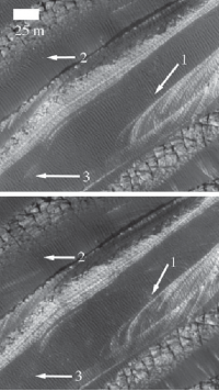
In two different papers published in two different journals in the past month, scientists have concluded that — despite the thinness of the planet’s atmosphere — the dunes and sands of Mars are being continually shaped and changed by its winds. In both papers the data from which this conclusion was drawn came from high resolution images taken by the HiRISE camera on Mars Reconnaissance Orbiter.
What is especially interesting about this conclusion is that the climate models that had been developed for the Martian atmosphere, combined with wind measurements gathered by the various Martian landers, had all suggested that the kind of strong winds necessary to move sand were rare. To quote the abstract of the paper published on Monday in the journal Geology, Bridges, et al,
Prior to Mars Reconnaissance Orbiter data, images of Mars showed no direct evidence for dune and ripple motion. This was consistent with climate models and lander measurements indicating that winds of sufficient intensity to mobilize sand were rare in the low-density atmosphere.
Similarly, the second paper, Silvestro, et al, published on October 22 in Geophysical Research Letters, stated that
results from wind tunnel simulations and atmospheric models show that such strong wind events should be rare in the current Martian atmospheric setting.
Yet, both studies found significant evidence that such winds do occur on Mars, and are moving sand in many different places.
» Read more
New data says scientists must look underground for life on Mars.
More info on the engine failure of Phobos-Grunt, and what might still be done to save the mission.
Phobos-Grunt appears to be in trouble in Earth orbit.
In a posting to an online forum for the Phobos-Grunt mission, Anton Ledkov of the Russian Space Research Institute reported that there was “no telemetry” from the spacecraft.
Another report suggests that a variety of engine thrusters did not fire as planned.
Mars Express takes a close look at one of Mars’ giant volcanoes, Tharsis Tholus.
At least two large sections have collapsed around its eastern and western flanks during its four-billion-year history and these catastrophes are now visible as scarps up to several kilometers high. The main feature of Tharsis Tholus is, however, the caldera in its center. It has an almost circular outline, about 32 x 34 km, and is ringed by faults that have allowed the caldera floor to subside by as much as 2.7 km.
Russia heads for Mars: a detailed look at the Phobos/Grunt sample return mission, set to launch on November 8.
I really wish the Russians good luck with this project. Not only would it herald their return to planetary science since the fall of the Soviet Union, success here would break their long string of failures to the red planet. Though their unmanned planetary program had some remarkable achievements during the Soviet era, of the 19 missions they flew to Mars in the 1960s, 1970s, and 1980s, all were failures, producing almost no useful data.
The Mars rover Opportunity has spotted a geological formation not previously seen anywhere on Mars.
With the end of the Mar500 simulated mission this coming Friday, the Russians are now proposing an eighteen month simulated Mars mission on board the International Space Station.
The Russians have been pushing to do this on ISS for years. Unfortunately, NASA has always resisted.
Yet, as I wrote in Leaving Earth, we will never be able to send humans to any other planets until we have flown at least one simulated mission, in zero gravity in Earth orbit, beforehand. Wernher von Braun pointed out this reality out back in the 1950s, and that reality has not changed in the ensuing half century. Not only will such a mission tell us a great deal about the medical issues of living in weightlessness for years at a time — issues that are far from trivial — it will give us the opportunity to find out the engineering problems of building a vessel capable of keeping humans alive during interplanetary flight, far from Earth.
» Read more
A series of technical problems have forced engineers to temporarily halt science operations on Mars Express.
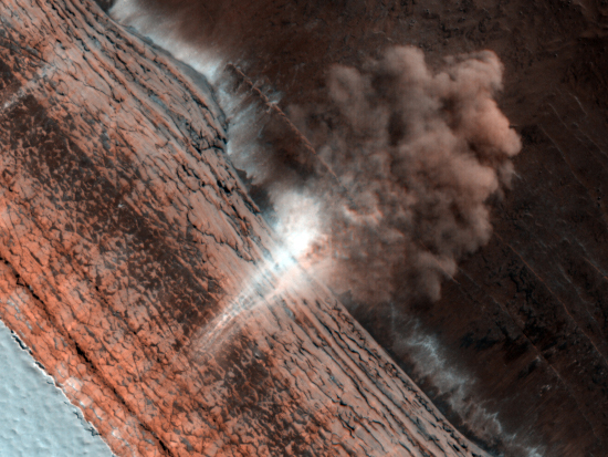
The Mars Reconnaissance Orbiter team today released this really cool image from Mars, showing an avalanche near the North Pole, in progress. The image looks directly down the cliff face from above. At the base of the cliff we can see the dust cloud from the crash of material billowing out away from the scarp.
What impresses me most about this image is that it was taken by an orbiting spacecraft approximately 200 miles above the planet’s surface, moving at thousands of miles an hour. Yet, the camera not only had the resolution to see the cloud of dust, it could snap the image fast enough to capture the actual fall of material (the white wisps down the side of the cliff that are reminiscent of a waterfall).
Also intriguing is the visible steep face of the cliff face itself. I know a lot of rock climbers who would love to literally get their hands (and chocks) on that rock face. And in Mars’s one-third gravity, rock climbing would surely be different.
Russia’s first attempt in decades to send a probe beyond Earth orbit is now set for a November 9 launch.
Phobos/Grunt is a combined orbiter and lander, and is aimed not at Mars but at the Martian moon Phobos.
Having topped 21 miles on its odometer, Opportunity is beginning its preparations for another winter on Mars.
The uncertainty of science: Hesperia Planum, a giant basin on Mars, assumed for decades to have been formed by volcanic activity, now appears to have instead been formed by water.
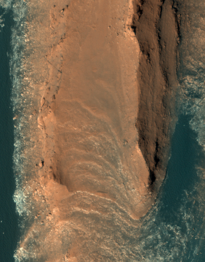
Last week the Mars Reconnaissance Orbiter team released this beautiful image of what they call “layered yardangs” on Mars.
What creates these sharp ridges? This layered terrain has been sculpted by the wind. The aligned ridges are called yardangs, which are formed in areas where the dominant erosional force is the wind. Yardangs are also found on Earth, usually in very dry areas.
What I see are majestic red cliffs rising out of a aqua-colored sand desert. What a place to visit!