
Chavez says capitalism may have ended life on Mars
You can’t make this stuff up: The socialist leader of Venezuela, Hugo Chavez, said today that he thinks capitalism is to blame for the lack of life on Mars.
You can’t make this stuff up: The socialist leader of Venezuela, Hugo Chavez, said today that he thinks capitalism is to blame for the lack of life on Mars.
The kapton tape used on the next Mars rover, Curiosity, releases enough methane of its own that it could mess up the rover’s other science.
The new colonial movement: China’s first probe to Mars is now set for a November launch.
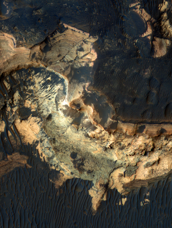
This week’s release of cool images from Mars Reconnaissance Orbiter included the color image below of a region on the floor of Holden Crater, one of the four possible landing sites for Curiosity, the Mars Science Laboratory planned for launch later this year. (If you want to see the entire image at higher resolution, you can download it here.)
Two things that immediately stand out about this image (other than this looks like an incredibly spectacular place to visit):
Astronauts on the Russian Mars500 simulated Mars mission simulated a Mars landing on Saturday. Key quote:
Three astronauts on the Mars500 simulated mission will make a simulated walk on the Mars “surface” Monday. After working 30 days on the simulated planet, the crew will then embark on a simulated 240-day return trip to Earth. Officials said the 520-day Mars500 mission is designed to test how humans cope with the physical and mental stresses of a long space flight.
Time for some more sightseeing on Mars. A recent news release from Mars Reconnaissance Orbiter noted the discovery of seasonal avalanches on Mars. This new image of the northern martian sand dunes illustrate again how the surface of Mars changes seasonally. The white patches on the ridges of the sand dunes is frozen carbon dioxide, dry ice that condenses on the crowns of the dunes every winter. When spring comes, the dry ice evaporates, and as it does so it disturbs the underlying sand, which then tumbles down the sides of the dunes, producing the dark streaks.
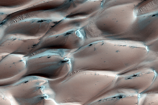
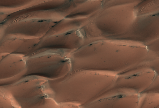
The process is less dramatic, however, than the avalanches seen in the previous news release, as suggested by this image below, showing the same dunes in summer without the dry ice. The dark streaks in the second image are not significantly different from the first, indicating that the process that forms them is slow and subtle.
Scientists have discovered significant seasonal changes to the northern martian sand dunes, including a number of large avalanches.
Here we go again: NASA’s already overbudget Mars Science Laboratory rover is in need of even more cash.
The ESA probe Mars Express flew past the Martian moon Phobos today. Great image!
A Mars map app for Android phones.
New research confirms that the Viking landers did find organics on Mars back in the 1970s. Listen also to the September 15, 2010 and September 23, 2010 radio interviews that John Batchelor and I did with Viking project scientist Gilbert Levin and Christopher McKay of the Ames Research Center on this very subject.
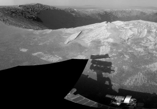
In its 14 mile multi-year trek to Endeavour Crater — now about half completed — the Mars rover Opportunity has stopped to take a short rest stop at a small crater.
The crater, dubbed “Santa Maria Crater” by the scientists who operater Opportunity, is about the size of a football field. What makes it especially interesting are the sharp rocks piled up on its rim, as they are probably debris ejected from the crater at impact. Since this material probably came from deep below the Martian surface, it is also likely to hold information about the Martian geological past, thereby making it a prime research site.
The uncertainty of science: Did the Martian methane signal come from Earth?
The hubbub about this week’s lunar solstice eclipse was, from my perspective, mostly manufactured press blather. For those who had never seen a lunar eclipse, it was a spectacular experience, but there really was nothing scientifically or technically unique about the fact that it happened to occur on the solstice.
However, below is an eclipse that is definitely unique both technically and scientifically. Scientists using the Mars rover Opportunity have filmed an eclipse on Mars, showing the Martian moon Phobos crossing in front of the Sun. Consider the engineering accomplishment: not only did they need to be able to calculate exactly when this would happen at a very particular spot on the Martian surface, they had to have a camera there able to take the movie. And they had to operate it from Earth!
And damn, do I want to rappel into them!
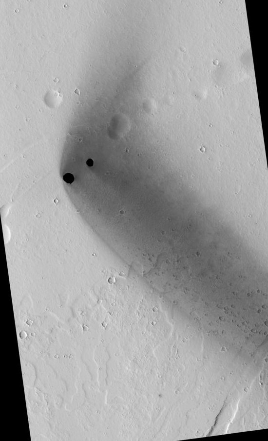
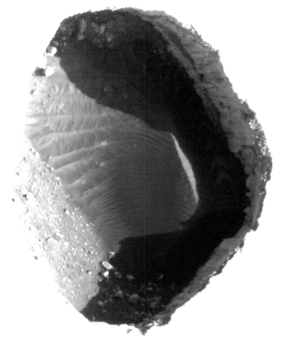
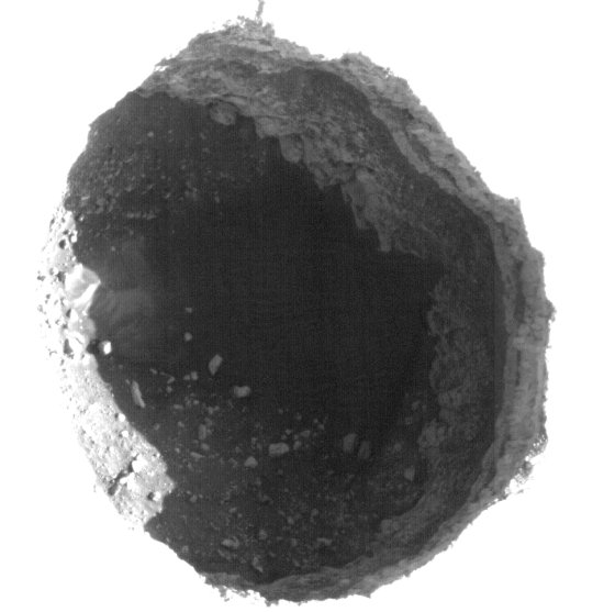
This week’s release of images from the HiRISE camera on Mars Reconnaissance Orbiter included these spectacular photos of two deep pits, approximately 180 and 310 meters in diameter and located aligned with a series of depressions that suggest additional passages at their base.
The first image shows the pits in the context of the surrounding terrain. From the caption:
These pits are aligned with what appears to be larger, degraded depressions. The wispy deposit may consist of dark material that has been either blown out of the pits or from some other source and scattered about by the local winds.
The next two images are heavily processed close-ups of each pit in order to bring out the detail within. From the caption:
The eastern most and smaller of the two pits contains boulders and sediment along its walls and brighter aeolian dune sediments on its floor. The larger, western most pit contains sediment and boulders with faint dune-like patterns visible on the deepest part of the floor. Both pits have steep eastern walls and more gently sloped western walls that transition gradually into the pit floor. Steep resistant ledges containing boulders that overhang and obscure the pit floors form the eastern walls.
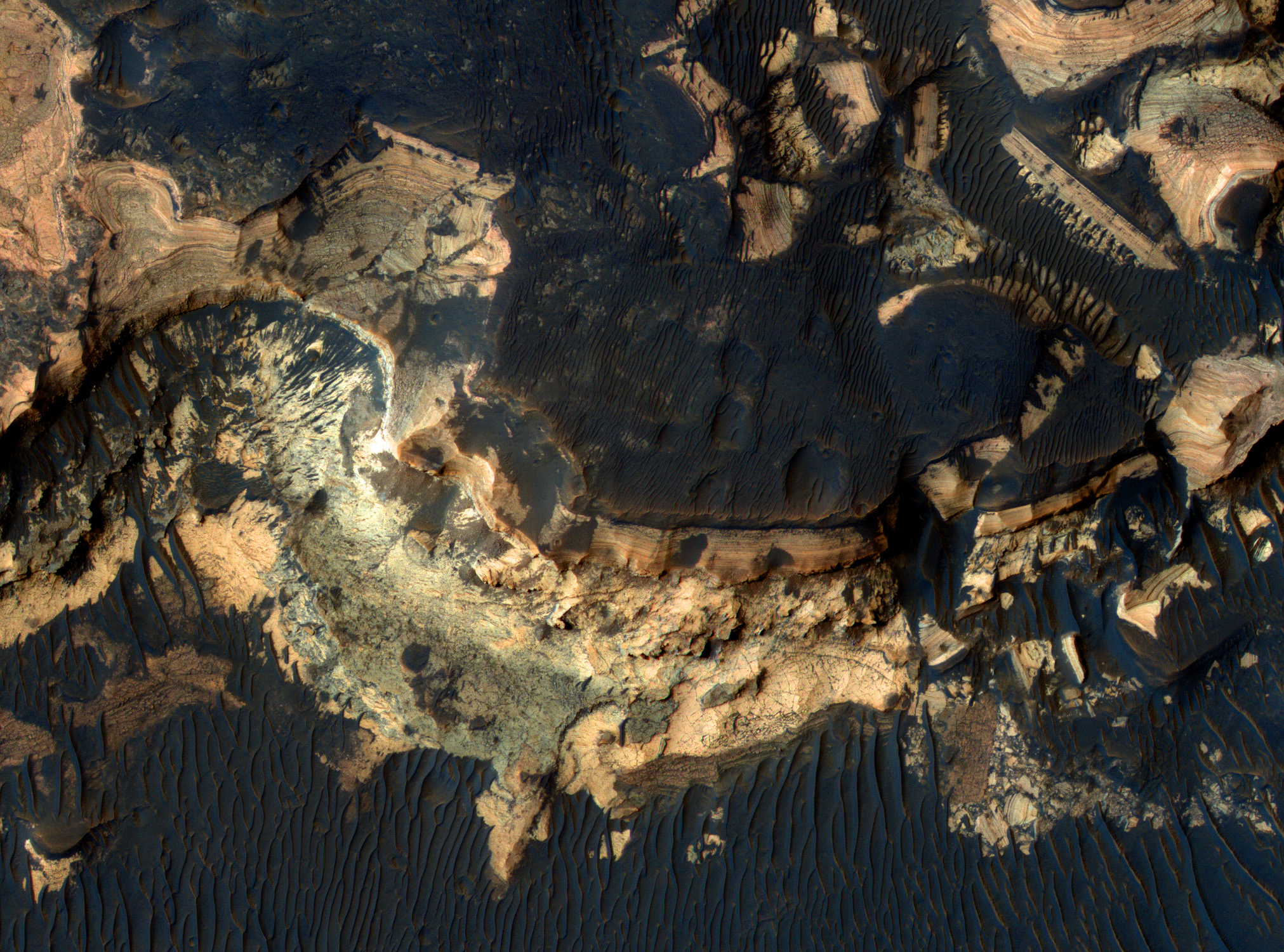
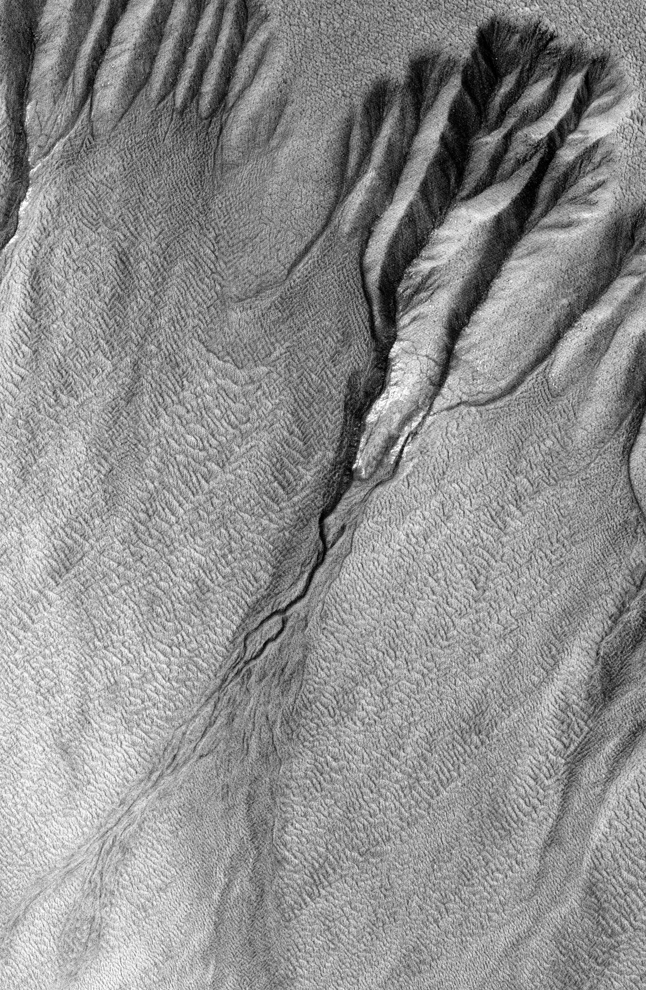
The image below from Mars Reconnaissance Orbiter shows gullies remarkably similar to gullies formed on Earth by flowing water, thus providing striking evidence that at some time in the past liquid water did flow on the Martian surface, something that is not possible now. Key quote from the caption:
The gullies shown in the subimage (approximately 710 x 1100 yards) have well developed alcoves, deeply incised channels, and large depositional fans, and are similar to terrestrial landscapes sculpted by surficial water.
The gullies shown in the subimage experienced several periods of activity, as evidenced by older channels cut by younger ones or by their deposits. The current and recent Martian temperatures and atmospheric conditions would not allow for water to be stable at the surface for extended periods of time: it is so cold that the water would freeze, and then it would sublime quickly, because the air is very thin and dry. These gullies could have formed under a different climate, or maybe by repeated bursts of transient fluids. Current leading hypotheses explaining the origin of gullies includes erosion from seepage or eruption of water from a subsurface aquifer, melting of ground ice, or dust-blanketed surface snow.
