Mars rover update: September 20, 2016

Opportunity comes first this time because it actually is more interesting.

Opportunity

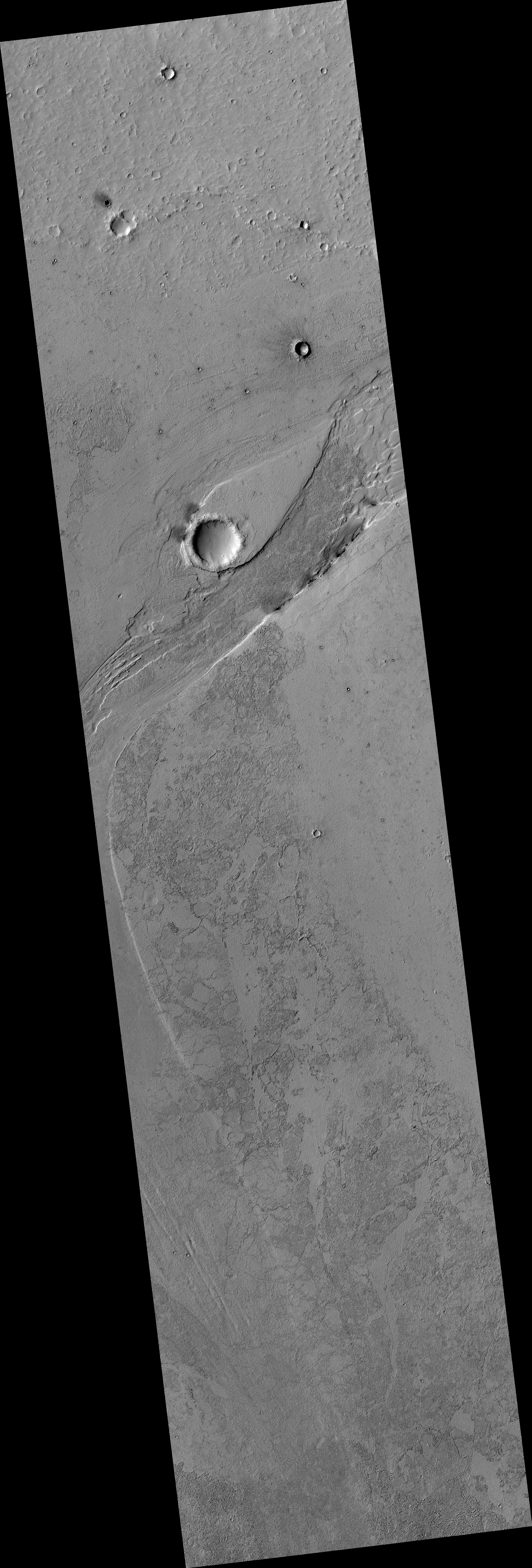
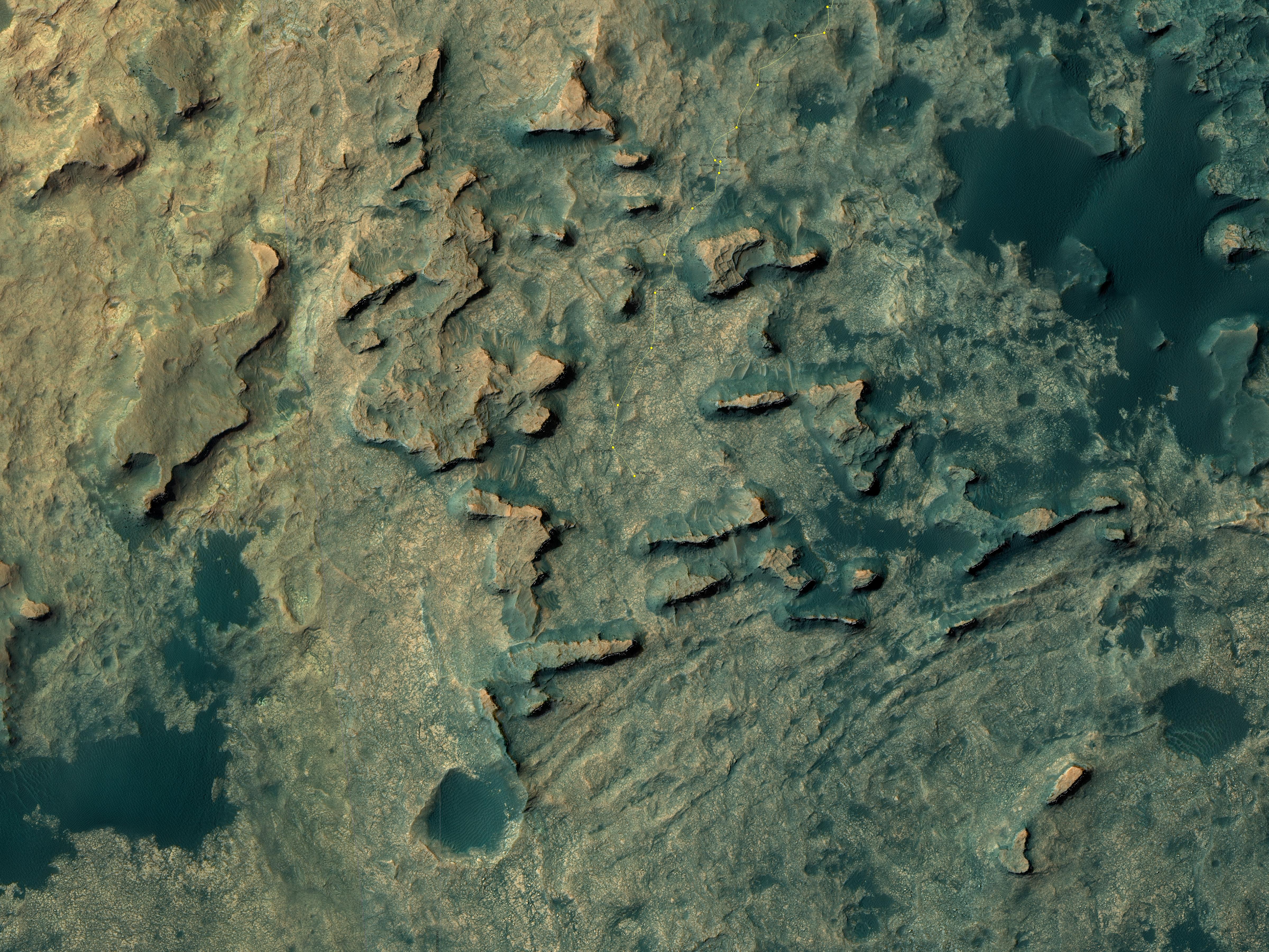
For the overall context of Opportunity’s travels at Endeavour Crater, see this post, Opportunityโ€™s future travels on Mars.

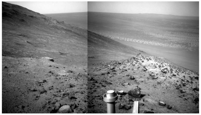
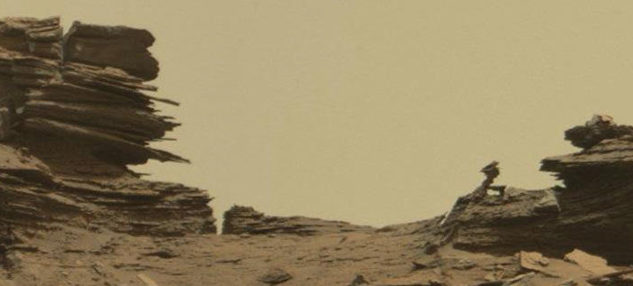
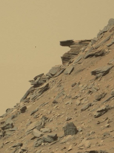
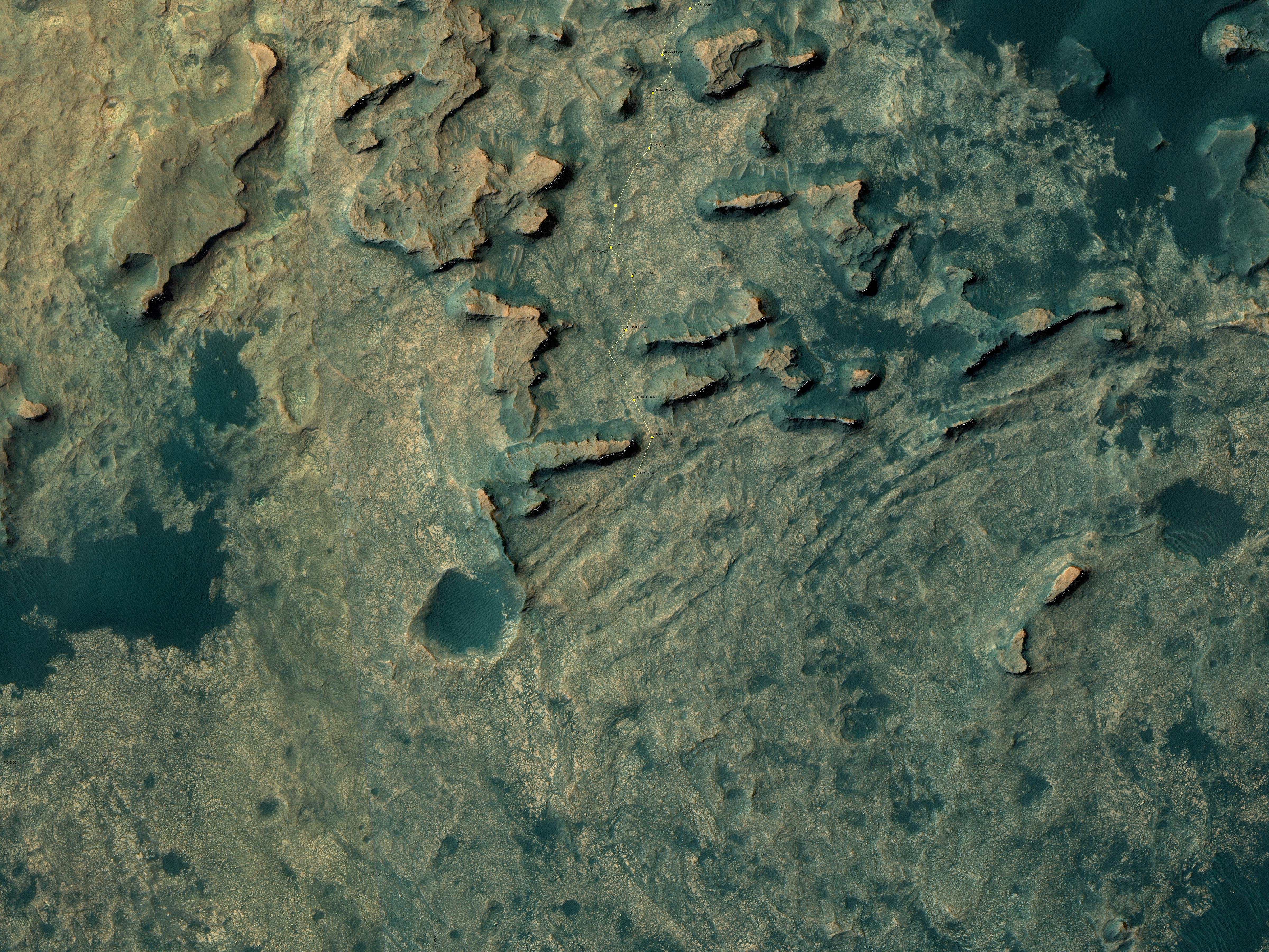
Having several choices on where to head, the Opportunity science team this week chose took what looks like the most daring route, heading almost due east towards the floor of Endeavour Crater. In fact, a review of their route and the images that the rover continues to take suggests that the panorama I created last week looked almost due east, not to the southeast as I had guessed. I have amended the most recent overhead traverse image, cropped and reduced below, to show what I now think that panorama was showing.
» Read more

1 comment

New evidence of lakes and streams in Mars’ recent past

Using data from three different orbiters scientists have mapped out a region of lakes and streams on Mars that appear to have contained liquid water a billion years after the red planet is believed to have dried up.

To bracket the time period when the fresh shallow valleys in Arabia Terra formed, scientists started with age estimates for 22 impact craters in the area. They assessed whether or not the valleys carved into the blankets of surrounding debris ejected from the craters, as an indicator of whether the valleys are older or younger than the craters. They concluded that this fairly wet period on Mars likely occurred between two and three billion years ago, long after it is generally thought that most of Mars’ original atmosphere had been lost and most of the remaining water on the planet had frozen.

The characteristics of the valleys support the interpretation that the climate was cold: “The rate at which water flowed through these valleys is consistent with runoff from melting snow,” Wilson said, “These weren’t rushing rivers. They have simple drainage patterns and did not form deep or complex systems like the ancient valley networks from early Mars.”

This region, Arabia Terra, is the same area where scientists have found fossilized rivers.

0 comments

A Mars Rover Update

I have decided to continue my Mars rover updates, and make them a regular mid-week feature here on Behind the Black. This is the first.

Curiosity

For the overall context of Curiosity’s travels, see this post, Pinpointing Curiosityโ€™s location in Gale Crater.

Since my last updates here and here, Curiosity has moved south through the gap between buttes to exit the Murray Butte area. The initial slopes of Mount Sharp lie ahead, an open road with no apparent rough terrain to slow travel.

Doing science however does slow travel, and for good reason. Once through the gap the science team decided to swung the rover west and up against the base of the gap’s western butte, rather than immediately head south to climb the mountain. The Mars Reconnaissance Orbiter image below, cropped and reduced, illustrates this path.
» Read more

3 comments

The flowing formations of Lethe Vallis

Cool image time! The Mars Reconnaissance Orbiter science team yesterday released several new images. Below is just one, cropped and reduced in resolution to post here. It shows a large flow channel called Lethe Vallis, formed first by lava, then hit by an impact which created a walled crater in its middle. Flood waters then followed, creating the tear-shaped dune surrounding the crater. In addition, erosion exposed the dark lava basalt below the surface on the edge of that tear-shaped dune. Within the crater itself can be seen ripple dunes formed by wind. As the scientists note,

This single image thus contains features formed by periglacial, volcanic, fluvial, impact, aeolian and mass wasting processes, all in one place.

Be sure to check out the full image.

Lethe Vallis

0 comments

Mars rover update

It is time for an update on the journeys of Curiosity and Opportunity on Mars!

First, Curiosity. Though the science team has not yet updated the rover’s Mars Reconnaissance Orbiter traverse map showing its travels, it appears from Curiosity’s most recent navigation camera images that the rover has moved passed the first butte that had been ahead and directly to the south in the traverse map shown in the last image of my post here. The image below the fold, cropped and reduced to show here, looks ahead to the second butte and the gap to the south. Beyond Mt Sharp can be seen rising up on the right, with the upcoming ground open and relatively smooth. The only issue will be the steepness of that terrain. Based on my previous overall look at the rover’s journey, I suspect they will contour to the left.
» Read more

1 comment

Opportunity’s steep downhill path

An update on Opportunity: The panorama I have created below from two images taken by its navigation camera and transmitted from Opportunity today, shows the steepness of the slope in Lewis and Clark Gap down which engineers are thinking of sending Opportunity. It appears also that Opportunity has moved closer to the gap since my post on Friday outlining the rover’s future travels.

I have not followed Opportunity’s entire journey on Mars close enough to say whether this will be the steepest downhill slope the rover has ever attempted. If not I suspect it is close to the steepest. I also suspect that they are still unsure whether they are going to attempt it, and are creeping slowly towards it to assess the situation.

Lewis and Clark Gap within Endeavour Crater's rim

7 comments

Opportunity’s future travels on Mars

Opportunity's future path

Approaching the gap

Having spent a lot of time recently analyzing the travels of Curiosity in Gale Crater and in the foothills to Mount Sharp, I decided this week that I also needed to do the same with Opportunity at Endeavour Crater.

The image above is a panorama that I have assembled from images taken by Opportunity’s navigation camera on Sol 4477 (sometime last week). To the right is a panorama assembled from images taken by the navigation camera several days later, on Sol 4481, after Opportunity had moved closer to the gap shown in the first picture above. The inset in the image above shows the location of the image on the right. The X shows Opportunity’s approximate position.

Below the fold is the most recent orbital mosiac showing Opportunity’s recent travels near Endearvour Crater and in Marathon Valley, cropped and annotated by me to indicate the areas seen by the two panoramas above. The red dot shows Opportunity’s present position.
» Read more

2 comments

NASA sets InSight’s new launch date to Mars

NASA has now set 2018 as the new launch date for its Mars InSight mission.

The mission was originally supposed to launch in 2016, but missed that launch window when significant problems cropped up during construction of the spacecraft’s French-built prime instrument. NASA has now taken much of the responsibility for building that instrument away from the French and given it to JPL.

The SEIS instrument — designed to measure ground movements as small as half the radius of a hydrogen atom — requires a perfect vacuum seal around its three main sensors in order to withstand harsh conditions on the Red Planet. Under what’s known as the mission “replan,” NASA’s Jet Propulsion Laboratory in Pasadena, California, will be responsible for redesigning, developing and qualifying the instrument’s evacuated container and the electrical feedthroughs that failed previously. France’s space agency, the Centre National d’ร‰tudes Spatiales (CNES), will focus on developing and delivering the key sensors for SEIS, integration of the sensors into the container, and the final integration of the instrument onto the spacecraft.

The cost for the changes and reschedule is estimated to be more than $150 million, adding to the budget strain in NASA’s science programs already caused by the overruns from the James Webb Space Telescope.

1 comment

The alien buttes of Mars

Weird Mars

The image above is cropped from a panorama created by reader Phil Veerkamp from images taken by Curiosity’s mast camera on August 25, 2016 of the terrain that partly surrounds the rover since it passed the Balanced Rock and traveled beyond Murray Buttes

The full image is too large to post here. However, if you click on the first link above you can either download it and peruse it at your leisure, or view it with your browser. You will definitely want to do so, as it is high resolution and shows a lot of strange and alien geology, including multiple slabs seemingly hanging in space because of the low gravity. (Hint: Be sure to pan all the way to the right!) On the image’s left Mount Sharp can be seen raising in the background. Below the fold I have annotated the most recent Mars Reconnaissance Orbiter image of Curiosity’s location to indicate what I think is the area included in this panorama. This MRO image also shows that once Curiosity gets through the narrow gap to the south, the path heading south up the mountain’s slopes will, for awhile at least, be relatively open with few large obstacles. The view will also change, as the rover will be out of the region of buttes.
» Read more

6 comments

Another balanced rock!

A new balanced rock

Cool image time! The image to the right, cropped to show here, was taken by Curiosity’s mast camera this week as it surveys the upcoming terrain so that scientists can choose its route. It shows another balanced rock that is far more unbalanced than the one the rover passed last week.

In reviewing the survey images, I am not exactly sure whether this rock is located along Curiosity’s future route, as I have not been able to locate it in any of the panorama images the rover has taken. If it is in the gap they are aiming for, then we shall soon see some additional close-ups. If not, then we will have to content ourselves with some other views that, when you think about it, are really just as good.

4 comments
1 167 168 169 170 171 212