Swirls of layers and dunes at the bottom of Valles Marineris

Overview map

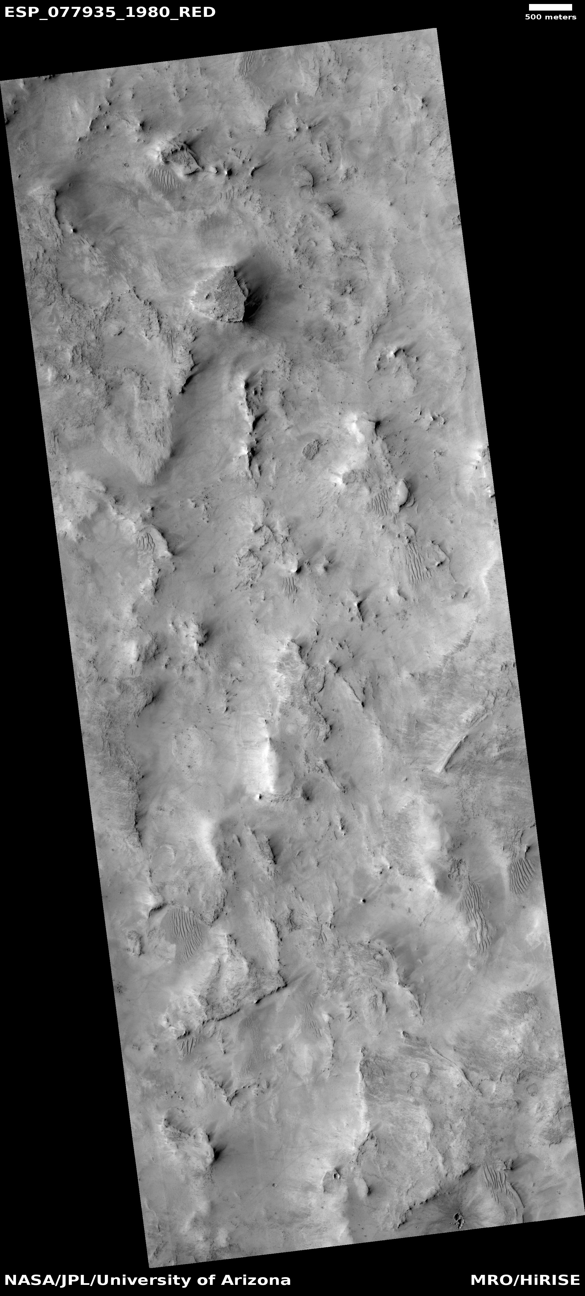
Swirls of layers and dunes
Click for original image.

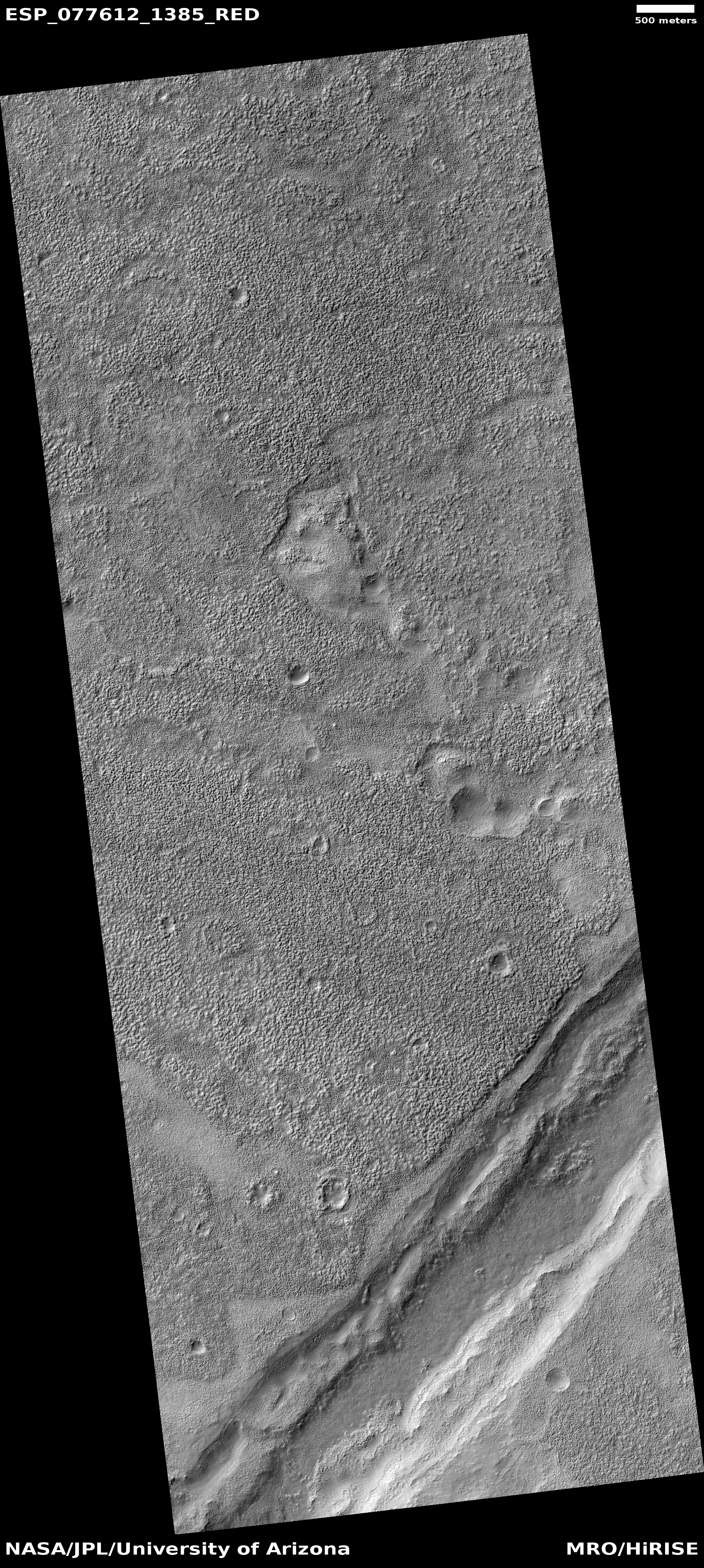
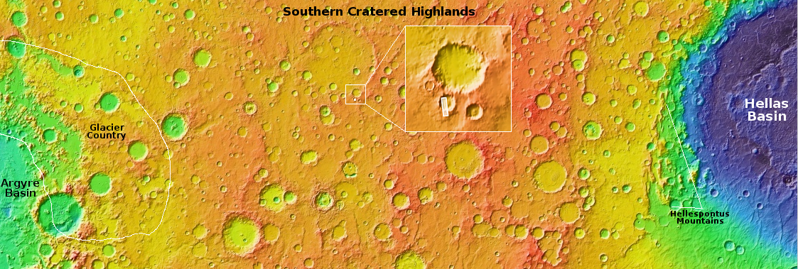
Cool image time! The picture to the right, cropped, reduced, and sharpened to post here, was taken on February 25, 2024 by the high resolution camera on Mars Reconnaissance Orbiter (MRO). It shows a small spot of the floor of Mars’ giant canyon Valles Marineris, the largest such canyon known in the solar system, as indicated by the white dot on the overview map above.

This location is not actually at the very bottom of the canyon, but on a very large mountainous bench extending out about 20 miles from the canyon’s south rim. It seems there is a lot of dust and sand on this bench, producing many miles of swirling dunes. It also appears there are many terraced layers in the region as well, which also swirl in curves going in many different directions. Though it appears that most of the swirls in this picture are from layers in the bedrock, this conclusion is not certain. For example, are the curves on the top of the mesa dunes or bedrock layers? The answer is hardly clear.

For scale, the canyon at this location is about 80 to 90 miles wide. The northern rim rises five miles from the bottom to the top, while the south rises seven miles. And yet, though five to ten times larger than Earth’s Grand Canyon, this is only a small side spur of Valles Marineris.

0 comments

Lava land on Mars

Lava land on Mars
Click for original image.

Cool image time! The picture to the right, cropped, reduced, and sharpened to post here, was taken on March 2, 2024 by the high resolution camera on Mars Reconnaissance Orbiter (MRO). It shows what the scientists label as “platy fractures.”

The ridges likely align with cracks that developed over time on this lava field, which then formed the ridges when magma oozed up from below. It is also possible that these events were closely linked, that the pressure from the magma below cracked this lava field, with the magma immediately oozing out. Because the pressure was evenly applied across the whole surface, it caused a network of cracks and plates, not a single vent or caldera. The even distribution of the pressure also caused only a small amount of lava to leak out to form the ridges.
» Read more

0 comments

Martian dunes with frost and a sublimating dry ice mantle

Martian dunes surrounded by frost
Click for original image.

Cool image time! The picture to the right, cropped to post here, was taken on March 16, 2024 by the high resolution camera of Mars Reconnaissance Orbiter (MRO). It was released today as a captioned picture from MRO’s camera team. As noted in the caption, written by the camera’s principal investigator Alfred McEwen:

This image shows a field a sand dunes in the Martian springtime while the seasonal carbon dioxide frost is sublimating into the air. This sublimation process is not at all uniform, instead creating a pattern of dark spots.

In addition, the inter-dune areas are also striking, with bright frost persisting in the troughs of polygons. Our enhanced-color cutout is centered on a brownish-colored inter-dune area.

Each winter the carbon dioxide in the Martian atmosphere falls as snow, mantling the surface in the latitudes above 60 degrees with a clear coat of dry ice. When spring arrives the sunlight passes through the mantle to heat the ground below, which in turn causes the base of the dry ice mantle to sublimate into gas. When the pressure builds enough, the gas breaks through the mantle at its weak points, spewing out and bringing with it dust from below, which stains the mantle with the dark spots.
» Read more

0 comments

Numerous layers in the interior slopes of Argyre Basin on Mars

Numerous layers on Mars
Click for original image.

The cool image to the right, cropped, reduced, and enhanced to post here, was taken on February 22, 2024 by the high resolution camera on Mars Reconnaissance Orbiter (MRO). It gives us another example the many-layered geological history of Mars, seen in numerous locations across the entire Martian surface.

This example shows many thin layers, going downhill about 450 feet from the mesa near the bottom of the picture to the low point near the picture’s top. At this resolution there appear to be roughly two dozen prominent layers in that descent, but a closer look suggests many more layers within those large layers. Like the terrain that Curiosity is traversing on Mount Sharp, the closer one gets the more layers one sees. And each layer signifies a different geological event, possibly even marking the annual seasons, each either adding or removing a layer of dust or ice, or placing down a new layer of lava.
» Read more

0 comments

Flat tadpole depression in ancient Martian crater

Flat tadpole depression in ancient Martian crater
Click for original image.

Cool image time! The picture to the right, rotated, cropped, reducedl, and enhanced to post here, was taken on February 24, 2024 by the high resolution camera on Mars Reconnaissance Orbiter (MRO). Dubbed a โ€œterrain sampleโ€ by the camera team, it was likely taken not as part of any specific research project but to fill a gap in the cameraโ€™s schedule so as to maintain that cameraโ€™s proper temperature. When they have to do this, they try to pick interesting targets, though there is no guarantee the result will be very interesting.

In this case the camera team already knew this location would have intriguing geology, based on an earlier terrain sample taken a year ago only eight miles to the south. The landscape here is a flat plateaus surrounding flat depressions, some of which appear connected by drainage channels. Today’s picture shows one flat depression with a short tail-like channel flowing into it.

Note the pockmarked surface. The many holes could be impact craters, but they also could be holes caused when the near-surface ice at this location sublimated into gas and bubbled upward to escape. Now all we see is dry bedrock, the flat ground riddled with holes.
» Read more

0 comments

Infeeder to a Martian paleolake

Infeeder to a Martian paleolake
Click for original image.

Cool image time! The picture to the right, rotated, cropped, and reduced to post here, was taken on December 21, 2023 by the high resolution camera on Mars Reconnaissance Orbiter (MRO). It shows what the scientists label as an “inlet to a paleolake.” I have used this context camera lower resolution image taken January 14, 2023 to fill in the blank central strip caused by a failed filter on the high resolution camera.

The elevation difference between the plateau on the lower left and the lake bottom on the upper right is about 700 feet. The inlet channel floor is about 200 feet below the plateau. We know it is ancient because of the number of small craters within it as well as on the lakebed below. It has been a very long time since any water or ice flowed down this channel to drain into the lake to the north.

While a lot of analysis of orbital data has found numerous examples of paleolakes in the dry equatoral regions of Mars (see here, here, here, here, and here , this particular example is so obvious not much analysis is needed, as shown in the overview map below.
» Read more

1 comment

Ancient flood lava in the Martian cratered highlands

Ancient flood lava on the cratered highlands of Mars
Click for original image.

Cool image time! The picture to the right, cropped, reduced, and sharpened to post here, was taken on February 4, 2024 by the high resolution camera on Mars Reconnaissance Orbiter (MRO).

The ridges were the primary reason this photo was taken, as they cover a 50-mile-square region of relatively flat terrain that also appears to be a series of steps downward to the west. The dotted line on the picture indicates one of those steps downward, with the plain to the west of that line about 100 to 200 feet lower that the plain to the east.

My first guess was that these ridges might be inverted channels, but that really didn’t make sense considering their random nature completely divorced from the downward grade. Then I took a wider view, and came up with a better guess.
» Read more

0 comments

Isolated flat-topped mesa inside large Martian crater

Isolated flat-topped mesa
Click for original image.

Cool image time! The picture to the right, cropped and reduced to post here, was taken on February 18, 2024 by the high resolution camera on Mars Reconnaissance Orbiter (MRO).

The camera team labels this “layers in butte”, but because we are looking straight down at this 400-foot-high butte, it is difficult to see any layers at all. Based on most Martian geology however it would be shocking if this butte is not made up of multiple horizontal layers, ending with that flat surface layer at the top. Moreover, the base of the mesa to the northeast is clearly made up of a series of terraces that appear obscured at other points due to the presence of dust and dunes.

A side view would help clarify the number of layers and their thickness, but it does appear that this butte contains evidence of the geology that once covered this whole area, but over eons has eroded everything away but this butte.
» Read more

0 comments

Scientists: Any ice trapped in Ceres’ permanently shadowed craters has to be very young

The permanently shadowed craters at Ceres' north pole
The permanently shadowed craters (blue) at Ceres’
north pole. Click for original image.

Scientists reviewing the archive data from the Dawn probe that orbited the asteroid Ceres from 2016 to 2018 have found that the permanently shadowed craters at the asteroid’s poles are periodically exposed to sunlight due to long term variations in Ceres’ orbit, meaning that any of the ice in those craters detected by Dawn must be extremely young.

When Ceres reaches its maximum axis tilt, which last occurred about 14,000 years ago, no crater on Ceres remains perennially shadowed and any ice in them must have quickly sublimated into space. โ€œThat leaves only one plausible explanation: The ice deposits must have formed more recently than that. The results suggest all of these ice deposits must have accumulated within the last 6,000 years or less. Considering that Ceres is well over 4 billion years old, that is a remarkably young age,โ€ Schorghofer said.

This does not mean that Ceres doesn’t have ice. In fact, it is very ice rich, below the surface. This data instead suggests that the surface remains active, and that there are processes bringing that underground ice to the surface on a regular basis. Except for these craters, which remain permanently shadowed for long time spans, that ice sublimates away relatively quickly. This result fits with earlier data from Dawn, that suggested many active locations on the surface, including its most distinct crater, Occator.

0 comments

A Martian rock with holes

A Martian rock with holes
Click for original image.

Cool image time! The picture to the right, cropped, reduced, and sharpened to post here, was taken on April 13, 2024 by the high resolution camera on the Mars rover Perseverance.

The largest rock in the picture is probably only one or a few feet or so across. It has two holes, one very visible in the center and a second less obvious in the shadow on the right. What makes the obvious hole most intriguing is that it appears it was formerly entirely enclosed by the boulder, and was exposed when a section broke off. That section is the smaller rock in the foreground. I wonder if the Perseverance team will bring the rover around to get a view of that smaller rock, to see if it has its own corresponding part of this hole.

Note the smoothness of the rocks. This smoothness is very similar to what Curiosity saw when it was either on the floor of Gale Crater, or at the base of Mount Sharp. In both cases that smoothness suggests either flowing water or glacial ice erosion, like the smooth cobbles one routinely finds in streambeds or in the moraines of glaciers.

As Curiosity climbed Mount Sharp the smoothness was replaced with a delicate flaky fleecework indicating many layers but little violent erosion capable of smoothing the surface (see for example the images here and here). It appears Perseverance is still low enough in Jezero Crater to be within the ancient active region, formed from flowing water or ice.

As for the holes, my guess is that this rock formed from lava, and the holes are what geologists call “vugs”, bubbles formed within the lava as it solidified.

2 comments

A Martian river of sand

A Martian river of sand
Click for original image.

Overview map
Click for interactive map.

Cool image time! The panorama above, cropped, reduced, enhanced, and flipped to post here, was taken on April 14, 2024 by the right navigation camera on the Mars rover Curiosity, created from a total of 31 images.

The full mosaic covers a full 360 degree view from where Curiosity presently sits, inside the slot canyon Gediz Vallis. The part shown above only covers a little more than half, looking west at the butte which forms the western wall of the slot canyon, as shown by the yellow lines and the arrow in the overview map to the right. The blue dot marks Curiosity’s present position, while the red dotted line its planned route.

What makes this part of the mosaic especially distinct is the narrow river of sand that flows downhill from the right to the left. While everywhere else the ground is heavily covered with rocks, along this strip the surface is smooth sand, with many frozen dunes resembling waves or ripples as the flows downhill slowly.

The river is formed against a low cliff wall, which is why the sand gathered along this strip. At the same time, the downhill grade to the left (north) is allowing the sand to carve a distinct path, at the base of that cliff.

I’ve said it before and I’ll say it again: Mars is alien, Mars is unique, but above all, Mars is wonderful.

2 comments

A squeezed Martian landscape

A squeezed Martian landscape
Click for original image.

Cool image time! The picture to the right, cropped, reduced, and sharpened to post here, was taken on February 20, 2024 by the high resolution camera on Mars Reconnaissance Orbiter (MRO). It shows what the scientists label “tilted blocks in the low northern latitudes.”

At first glance this circle of tilted blocks appear to mark a place where something erupted from below, pushing and cracking the blocks away in all directions. If there was an eruption however it appears very little if anything poured out from below. Instead, the ground inside the hollow in the center is about the same elevation as the ground surrounding the tilted blocks.

Clearly some pressure from below pushed these surface blocks upward to crack and tilt, but the answer cannot be found in this close-up picture. Instead, we need to look wider, not only at the overview map below, but at the inset on that overview map.
» Read more

0 comments
1 42 43 44 45 46 89