The MarCo cubesat success

Mars as seen by MarCo-B

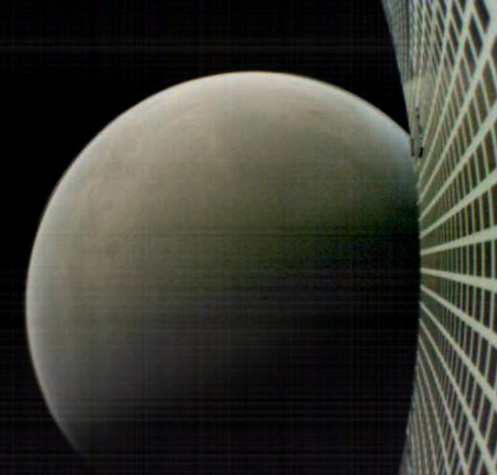
The two MarCO cubesats that successfully relayed data from InSight to Earth during its landing yesterday continue to function, with one even sending back images. The photo on the right, cropped and reduced slightly to post here, was taken by MarCo-B.

Neither of the MarCO CubeSats carry science instruments, but that didn’t stop the team from testing whether future CubeSats could perform useful science at Mars. As MarCO-A flew by, it conducted some impromptu radio science, transmitting signals through the edge of Mars’ atmosphere. Interference from the Martian atmosphere changes the signal when received on Earth, allowing scientists to determine how much atmosphere is present and, to some degree, what it’s made of.

“CubeSats have incredible potential to carry cameras and science instruments out to deep space,” said John Baker, JPL’s program manager for small spacecraft. “They’ll never replace the more capable spacecraft NASA is best known for developing. But they’re low-cost ride-alongs that can allow us to explore in new ways.”

As a bonus, some consumer-grade cameras aboard MarCO provided “drive-by” images as the CubeSats sailed past Mars. MarCO-B was programmed to turn so that it could image the planet in a sequence of shots as it approached Mars (before launch, MarCO-A’s cameras were found to be either non-functioning or too blurry to use).

This engineering test proves that we don’t need to build billion dollar spacecraft every time we wish to send an unmanned scouting ship to another world. Cubesats will soon do the job quite well, and for a tenth the cost.

And there will be a lot of money to be made. Governments and private entities of all types will be eager to buy the services of the garage-built planetary cubesats that private companies are going to soon be building, in large numbers.

4 comments

InSight’s solar panels have opened

InSight engineers have now reported that solar panels have opened and are functioning properly.

NASA’s InSight has sent signals to Earth indicating that its solar panels are open and collecting sunlight on the Martian surface. NASA’s Mars Odyssey orbiter relayed the signals, which were received on Earth at about 5:30 p.m. PST (8:30 p.m. EST). Solar array deployment ensures the spacecraft can recharge its batteries each day. Odyssey also relayed a pair of images showing InSight’s landing site.

“The InSight team can rest a little easier tonight now that we know the spacecraft solar arrays are deployed and recharging the batteries,” said Tom Hoffman, InSight’s project manager at NASA’s Jet Propulsion Laboratory in Pasadena, California.

This was the last major event in the landing sequence, and with it they can now shift to the slow deployment of instruments over the next few weeks. Results from this spacecraft will not be sudden or spectacular. It is going to take time to get the spectrometer placed and than time to gather quake data.

1 comment

InSight has successfully landed

NASA engineers have received confirmation that InSight has successfully touched down on the Martian surface.

Don’t count your chickens yet. They need to wait about five hours for the dust, kicked up by landing, to settle before they try opening the solar panels. That must succeed, or the mission will fail, having no source of power.

The landing information was relayed through the two MARCO cubesats flying past Mars, a landmark engineering achievement that in a sense is more significant than the landing itself. These cubesats have demonstrated that smallsats can do complex interplanetary tasks. Expect a revolution in the planetary space exploration world.

7 comments

Present and future landing sites on Mars

With InSight’s landing on Mars set for 11:54 am (Pacific) this coming Monday, November 26, 2018, I decided to put together a map of Mars showing the location of all the successful landers/rovers, adding the landing sites for the planned landers/rovers through 2020. This will give some context to InSight’s landing site.

Landing sites on Mars

The map does not show the landing sites for the failed Soviet, American, and British landers.

As I noted in describing the Mars2020 landing site, the location of the bulk of these landing sites, along the transition zone from the southern highlands and the northern lowlands, demonstrates the areas of the planet that interest geologists the most. It is here that we find many shoreline features, suggestive of the ocean that many scientists theorize existed intermittently in the northern lowlands. It is here that planetary scientists can quickly gather the most information about Martian geological history. And it is here that they have the opportunity to study the widest range of rock types.

From an explorer’s perspective, however, this approach has its limits. It does not provide us a look at a wide variety of locations. It is not directly aimed at finding lower latitude locations where ice might actually exist. And it is decidedly not focused in studying the planet from the perspective of future colonists. I am sometimes frustrated that we have as yet no plans to send any rovers into Marineris Valles, or to the western slopes of Arsia Mons, the southern most volcano in the chain of three giant volcanoes where there are indications that ice might exist underground, or to any of the places where caves are known to exist where a colony could be built more easily. In fact, the caves on the slopes of Arsia Mons seems a prime exploration target.

Eventually these locations will be explored, likely by private landers aimed at scouting out locations for future private settlements. I am just impatient.

6 comments

India wants international instruments for its Venus mission

The new colonial movement: India has requested science instruments proposals from the international community for its planned Venus orbiter, set to launch in 2023.

ISRO has already selected 12 instruments, proposed by Indian scientists, including cameras and chemical analyzers to study the atmosphere. Now, itโ€™s hoping other scientists will join. โ€œPlanetary exploration should be all about global partnerships,โ€ says Kailasavadivoo Sivan, a rocket scientist and ISROโ€™s chair. (The deadline for submitting proposals is 20 December.)

For me, the big news with this article is that it is the very first I have seen that actually spells out Sivan’s first name. Since he became head of ISRO in January 2018, he has only been listed as “K. Sivan” in every single article, even those describing his background when he was appointed. Now that I have learned what a tongue-twister that first name is, I can understand why they abbreviate it.

On a more serious note, this article indicates the growing maturity of India’s space effort. They not only are planning a mission to Venus, they will fly missions to the Moon in January and Mars in 2022, and intend to launch their first manned mission in that same time period.

0 comments

The soft landslides of Mars

A soft avalanche on Mars

Context image of landslide

The light gravity of Mars, combined with different materials, a lot of dust, and a geological history different from Earth, produces events that — though reminiscent of similar geological events on Earth — are definitely not the same.

The image above, cropped and reduced to post here, was taken by the high resolution camera on Mars Reconnaissance Orbiter (MRO) and was one of the many uncaptioned images released in the November archive. If you click on the image you can see the full resolution version. It shows the tongue of a landslide inside a crater located in the planet’s southern highlands.

You can immediately see why I call it a soft landslide. The craters on its top are barely visible, as if they hit a soft surface that absorbed most of the impact. The grooves spreading southward in the slide suggest that this solid material flowed almost like mud. And the soft, smooth surface head of the slide suggests an almost liquid-like flow. As far as I can tell, this landslide had few large boulders. It was made up instead of small particles of about the same size.

To the right is an image showing the wider context of the above image, taken by Mars Odyssey and cropped and annotated by me to post here. The white box shows the entire area photographed by the full resolution image of the landslide, with the tongue of the landslide at the bottom of the box. If you look at the floor of this crater, you can see what looks like the ghost of a past smaller impact, seemingly buried in either a field of lava or soft dusty regolith. The smoothness of the crater floor also suggests a material softness, allowing it to settle into a pondlike featureless flat plain.
» Read more

0 comments

NASA picks Mars 2020 landing site: Jezero Crater

Jezero Crater

NASA has picked Jezero Crater has the landing site for its as yet unnamed 2020 Mars rover.

Jezero Crater is located on the western edge of Isidis Planitia, a giant impact basin just north of the Martian equator. Western Isidis presents some of the oldest and most scientifically interesting landscapes Mars has to offer. Mission scientists believe the 28-mile-wide (45-kilometer) crater, once home to an ancient river delta, could have collected and preserved ancient organic molecules and other potential signs of microbial life from the water and sediments that flowed into the crater billions of years ago.

Jezero Craterโ€™s ancient lake-delta system offers many promising sampling targets of at least five different kinds of rock, including clays and carbonates that have high potential to preserve signatures of past life. In addition, the material carried into the delta from a large watershed may contain a wide variety of minerals from inside and outside the crater.

The geologic diversity that makes Jezero so appealing to Mars 2020 scientists also makes it a challenge for the teamโ€™s entry, descent and landing (EDL) engineers. Along with the massive nearby river delta and small crater impacts, the site contains numerous boulders and rocks to the east, cliffs to the west, and depressions filled with aeolian bedforms (wind-derived ripples in sand that could trap a rover) in several locations.

The red dot on the map of Mars below shows this location. The blue dot is Gale Crater where Curiosity landed. The purple dot is the landing site for the European ExoMars rover. The yellow dot is where Opportunity has been roving, and the black dot is Spirit’s location.
» Read more

5 comments

Sunset/sunrise on Mars

The sun on Mars's horizon

Cool image time! The image on the right, reduced to post here, was taken by Curiosity during a photo campaign this week to monitor Mars’s atmosphere. It looks out to the horizon at the Sun. I think the view is eastward, at Mount Sharp, as the Sun rises, but I am not sure. It might be looking west across the crater rim at sunset.

If you click on the image you can see it at full resolution. The haziness in the atmosphere might be left over from this summer’s global dust storm, but probably not, as I have read numerous reports in connection with Opportunity saying the storm is completely over and the atmosphere has now cleared. More likely it is from the windy conditions that are simply present these days at Gale Crater.

Regardless, it is quite cool because it illustrates how far we have come since the first planetary missions half a century ago. We can now routinely watch a sunset on Mars.

0 comments

Escape velocity on Phobos changes a lot depending on location

A new computer analysis of the shape of the gravitational field of the Martian moon Phobos suggests that the escape velocity varies significantly, depending on where you are on the moon’s surface.

Phobos is an odd duck among our solar systemโ€™s moons. Itโ€™s tiny (a fraction of a percent the size of our own moon) and is shaped like a potato; that weird shape draws gravity to different places, depending on where you are.

All these features make Phobos a challenge to travel on, researchers report in Advances in Space Research. In some places, moving any faster than 5 kilometers per hour would be enough to free you from the moonโ€™s meager gravitational pull, sending you off into space where youโ€™d likely be captured by Marsโ€™s gravity and end up orbiting the Red Planet. The fastest you could travel anywhere on Phobos would be about 36 kilometers per hour, or a little faster than a golf cart, the team finds.

Obviously, this must be recognized for any mission trying to land and explore the moon.

0 comments

Volcanic rivers on Mars

Granicus Valles

Cool image time! The photo on the right, cropped and reduced to post here, was part of the November image release from the high resolution camera on Mars Reconnaissance Orbiter (MRO). If you click on the image you can see the full resolution picture.

The uncaptioned release webpage is dubbed “Faults in Granicus Valles.” The image itself only shows a small part of Granicus Valles, named after a river in Turkey, that flows down from the estern slopes of the giant volcano Elysium Mons. While far smaller than the four big Martian volcanoes in the Tharsis region to the east and near Marines Valles (which I highlight often), Elysium Mons still outshines anything on Earth at a height of almost 30,000 feet and a width of 150 miles. It sits at about the same northern latitude of Olympus Mons, but all by itself, rising up at the very northern edge of the transition zone between the southern highlands and the northern plains, with the vast Utopia Basin, the second deepest basin on Mars, to the west.

Overview of Elysium Mons and Granicus Valles

Granicus Valles itself is almost five hundred miles long. At its beginning it flows in a single straight fault, but once it enters the northern plains of Utopia Basin it begins to meander and break up into multiple tributaries. The MRO image above shows only a tiny portion in the northern plains, as illustrated by the white box in the overview map to the left.
» Read more

0 comments

More Pits on Mars!

Pits near Arsia Mons

Cool image time! In the November image release from the high resolution camera on Mars Reconnaissance Orbiter (MRO) were three images, dubbed by me in the collage above as number one, number two, and number three, showing pits south of Arsia Mons, the southernmost volcano in the chain of three giant volcanoes to the east of Mars’s largest volcano, Olympus Mons, and to the west of the Marineris Valles valley.

Mars overview showing pit locations

The image on the right provides the geographical context of the three pits. They are all south of the volcano on the vast lava flow plains that surround it. The location of pits #1 and #2 is especially intriguing, on the east and west edges of what appears to be a large lava flow that had burst out from the volcano, leaving a large lava field covering a vast area several hundred miles across just to the south. You can also see a similar large lava field to the north of the volcano. Both fields appear to have been formed when lava poured through the breaks created by the fault that cuts through the volcano from the northeast to the southwest.
» Read more

2 comments

The ExoMars 2020 landing site

ExoMars 2020 landing site

Last week the European Space Agency (ESA) announced the final chosen landing site for their 2020 ExoMars rover, a region called Oxia Planum.

Since then they have posted several detailed overview maps describing this region. The image on the right, reduced slightly to post here, shows the final two candidate elliptical landing sites in black, with Oxia Planum on the left. The caption for this image adds this tantalizing detail:

Both landing site candidates lie close to the transition between the cratered northern highlands and the southern lowlands of Mars. They lie just north of the equator, in a region with many channels cutting through from the southern highlands to the northern lowlands. As such, they preserve a rich record of geological history from the planet’s wetter past, billions of years ago.

To understand better what they mean by this, we need to zoom out.
» Read more

1 comment
1 146 147 148 149 150 212