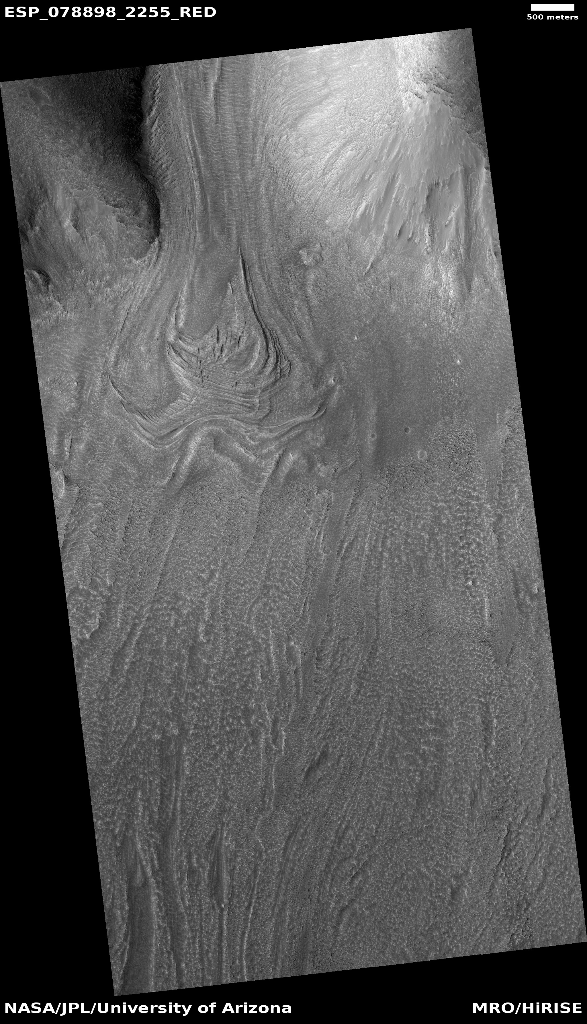
Sublimating scallops on Mars

Giant scallop on Mars
Click for full image.

Today’s cool image, shown in a rotated, cropped, and reduced version to the right, gives us a close-up look at one of the giant scallops found in the high mid-latitudes of the northern lowland plains of Mars, specifically in Utopia Basin north of the landing sites of both Perseverance and Zhurong. In fact, this particular image is only a few miles north of one of my previous cool images, Giant scallops on Mars, posted in December 2019.

The image was taken on February 3, 2021 by the high resolution camera on Mars Reconnaissance Orbiter (MRO). While such scallops are not unusual in the mid-latitudes, their formation process is not well understood. As I noted in the 2019 post, ” scientists believe [pdf] the formation process is related to the sublimation of underground ice.”

According to [one hypothesis] scallop formation should be ongoing at the present time. Sublimation of interstitial ice could induce a collapse of material, initially as a small pit, then growing [away from the equator] because of greater solar heating on [that] side. Nearby scallops would coalesce together as can be seen to have occurred.

This hypothesis is not proven, and today’s cool image raises questions about it. Though the bright material at its center suggests exposed ice, supporting the idea that sublimation of ice near the surface created the scallop, the scallop scarps seem more extended and distinct to the south, not the north as this hypothesis proposes. Sunlight should hit the northern scarps more, which suggests they should retreat more instead of the southern scarp.

The overview map below provides the context.
» Read more

First images from Ingenuity’s 9th flight today

Ingenuity landing, July 5, 2021

Ingenuity has apparently completed its 9th flight on Mars, its most challenging yet attempted. Based on the six images so far released from that flight, all taking during its landing, it appears the flight was successful. Or at least, the helicopter landed without incident or damage.

The photo to the right was the last picture taken just before touch down. From the caption:

NASA’s Ingenuity Mars Helicopter acquired this image using its navigation camera. This camera is mounted in the helicopter’s fuselage and pointed directly downward to track the ground during flight.

The dark shadow of the helicopter is clearly visible. If you want to see the entire sequence of six images, go to the Ingenuity raw image website and pick the “latest images” filter in the right column. At present it shows this sequence, though I am certain as the day passes images from the entire flight will start appearing.

As noted at the first link above, the flight was to be more than twice as long as any previous flight while flying over the roughest terrain. There was the real risk that its software would become confused by that terrain.

Next Ingenuity flight to push envelope significantly

Ingenuity's 9th flight plan
Click for full image.

The engineers running the Mars helicopter Ingenuity revealed today that they will be attempting their most ambitious flight for the helicopter’s ninth flight, presently scheduled for no earlier than July 4th.

I have annotated the map to the right to show Ingenuity’s present position and its approximate landing area.

Without question this flight will be the riskiest taken by Ingenuity so far, more than doubling the flight distance achieved on any previous flight. More important, it will be flying over terrain far rougher than it was initially designed for.
» Read more

More parachute problems for Europe’s Franklin Mars rover

During a parachute drop test in late June, following a redesign of the parachute with U.S. help, engineers for the ExoMars Rosalind Franklin Mars rover found the chute still experienced problems that tore it during deployment.

They actually performed two drop tests, a day apart, using two different parachutes, with the first test apparently going off without a hitch. However, according to the press release:

“The performance of the second main parachute was not perfect but much improved thanks to the adjustments made to the bag and canopy. After a smooth extraction from the bag, we experienced an unexpected detachment of the pilot chute during final inflation. This likely means that the main parachute canopy suffered extra pressure in certain parts. This created a tear that was contained by a Kevlar reinforcement ring. Despite that, it fulfilled its expected deceleration and the descent module was recovered in good state.”

I have embedded below the fold the only video released by the European Space Agency. It is not clear whether this is from the first or second test. Near the end it appears that the pilot chute above the main chute might be separated, but the video ends before that can be confirmed.

Though ESA has apparently improved the chute’s performance significantly since its earlier failures that contributed to the delay of ExoMars from last year to 2022, they still haven’t gotten the chute completely right. Fortunately they still have time to get it fixed before that ’22 launch.
» Read more

Perseverance’s most recent view of Jezero Crater

Panorama by Perseverance, Sol 130, July 2, 2021
Click for full resolution.

Overview map
Click for interactive map.

Cool image time! The panorama above, reduced to post here, is made from two navigation camera images on the Mars rover Perseverance, found here and here.

The map to the right, taken from the “Where is Perseverance?” website and annotated further by me, shows with the yellow lines what I think (but am not sure) is the area seen in the panorama.

The navigation cameras on Perseverance are more wide angle than the navigation cameras on Curiosity, in order to cover a larger area. They thus produce a slight fisheye distortion, illustrated by the curve of the horizon.

The large mountain in the center right is likely the crater rim. You can also see the knobs to the left as indicated on the overview map. The rover is now about halfway to the southernmost planned spot it is expected to reach within the floor of Jezero Crater, which is about a half to three quarters of a mile further south.

The terrain seems quite desolate and barren, which of course is no surprise, because that is what it is like on all of the surface of Mars. No plant life, just rocks and dirt. While Curiosity is now in the mountains, Perseverance remains on the crater floor, so the points of interest (from the mere tourist’s perspective) are small or far away.

Al-Amal detects Martian aurora

Aurora on Mars

The United Arab Emirates Al-Amal Mars orbiter has detected evidence of a Martian aurora that would be visible at night for short periods.

The ultraviolet images to the right have been reduced slightly to post here.

These three images of atomic oxygen emission at a wavelength of 103.4 nm from the planet Mars were obtained by the Emirates Mars Ultraviolet Spectrometer instrument on 22 April, 23 April, and 06 May 2021 respectively. The full set of data collected during these observations include far and extreme ultraviolet auroral emissions which have never been imaged before at Mars. The beacons of light that stand out against the dark nightside disk are highly structured discrete aurora, which traces out where energetic particles excite the atmosphere after being funneled down by a patchy network of crustal magnetic fields that originate from minerals on the surface of Mars.

Though Mars does not have a magnetic field, it is believed that sections of the planet’s crust are magnetized, and under the right conditions can guide the charged particles from the Sun’s solar wind to the night side to hit the atmosphere where they break up and produce the aurora. Because there is no magnetic field however the particles are not guided by the field lines to the poles, but to different spots at all latitudes, depending on circumstances.

Scientists solve methane data conflict on Mars

Using the methane detector on the rover Curiosity scientists now think they have solved the mystery why Curiosity has detected methane in the atmosphere near the surface while Europe’s Trace Gas Orbiter fails to detect any methane at all.

[Planetary scientist John E. Moores from York University in Toronto], as well as other Curiosity team members studying wind patterns in Gale Crater, hypothesized that the discrepancy between methane measurements comes down to the time of day they’re taken. Because it needs a lot of power, TLS [Curiosity’s methane detector] operates mostly at night when no other Curiosity instruments are working. The Martian atmosphere is calm at night, Moores noted, so the methane seeping from the ground builds up near the surface where Curiosity can detect it.

The Trace Gas Orbiter, on the other hand, requires sunlight to pinpoint methane about 3 miles, or 5 kilometers, above the surface. “Any atmosphere near a planet’s surface goes through a cycle during the day,” Moores said. Heat from the Sun churns the atmosphere as warm air rises and cool air sinks. Thus, the methane that is confined near the surface at night is mixed into the broader atmosphere during the day, which dilutes it to undetectable levels. “So I realized no instrument, especially an orbiting one, would see anything,” Moores said.

Immediately, the Curiosity team decided to test Moores’ prediction by collecting the first high-precision daytime measurements. TLS measured methane consecutively over the course of one Martian day, bracketing one nighttime measurement with two daytime ones. With each experiment, SAM sucked in Martian air for two hours, continuously removing the carbon dioxide, which makes up 95% of the planet’s atmosphere. This left a concentrated sample of methane that TLS could easily measure by passing an infrared laser beam through it many times, one that’s tuned to use a precise wavelength of light that is absorbed by methane.

“John predicted that methane should effectively go down to zero during the day, and our two daytime measurements confirmed that,” said Paul Mahaffy, the principal investigator of SAM, who’s based at NASA’s Goddard Space Flight Center in Greenbelt, Maryland. TLS’ nighttime measurement fit neatly within the average the team had already established. “So that’s one way of putting to bed this big discrepancy,” Mahaffy said.

While this explains the data conflict, it does not yet explain where the methane is coming from. It is suspected it is coming from underground, but why and from what is still unclear. Nor do scientists yet understand why it doesn’t accumulate enough in the atmosphere for Trace Gas Orbiter to detect it. Something is causing the methane to break up sooner than expected.

Dust covering solar panels threatens to end InSight mission

The InSight science team has revealed that the amount of dust that presently covers the solar panels on the Mars lander has now reduced their available power by about 80%, and if a dust devil doesn’t soon blow the dust off they will have to shut the spacecraft down sometime in the next ten months.

“The dust accumulation on the solar arrays has been considerable. We have about 80% obscuration of the arrays,” said Bruce Banerdt, principal investigator for the InSight mission at NASA’s Jet Propulsion Laboratory (JPL) in Southern California, according to SpaceNews.

Banerdt showed the impact of the declining power levels during a June 21 meeting of NASA’s Mars Exploration Program Analysis Group. When InSight landed near the Martian equator in November 2018, he said, the robot was generating roughly 5,000 watt-hours of power. Today that level is less than 700 watt-hours.

None of this is a surprise. Both the Opportunity and Spirit rovers faced the same problems. Both however were able to recover because periodically a dust devil would fly over the rover and clear the dust from the solar panels.

InSight however has not so far been lucky. While it has seen many nearby dust devils with its camera, none has come close enough to sweep the solar panels clean.

As the power has declined they have shut off various systems in order to keep the lander’s prime instrument, its seismometer, operating continuously. Engineers have also been using the scoop on the lander’s robot arm to try to dislodge some of the dust, with only a very very limited success. If the panels are not cleared soon, however, engineers will eventually be forced to shut everything down.

Paisley terrain on Mars

paisley terrain on Mars
Click for full image.

Cool image time! The photo to the right, cropped and reduced to post here, is actually a somewhat old image from the high resolution camera on Mars Reconnaissance Orbiter (MRO). It was taken more than a decade ago, on December 28, 2010, and featured as a captioned image one month later. I post it now because it was recently featured as MRO’s picture of the day, and thought it deserved a new look. As the caption from 2010, written by planetary scientist Alfred McEwen, noted,

Remember those paisley shirts during the summer of love in 1967? If so, this terrain may look somewhat familiar.

How did this terrain really form? One theory is that it’s a landslide deposit, perhaps associated with draining an ancient lake.

The overview map below might help make sense of this theory.
» Read more

Scientists question existence of liquid water lake under Martian south pole

The uncertainty of science: A re-analysis of the ground-penetrating radar data that suggested there was a liquid water lake under the Martian south pole has found that it might not be liquid water at all, but either “clays, metal-bearing minerals, or saline ice.”

The abstract can be read here.

The radar data, obtained by the European orbiter Mars Express, definitely shows a layer of bright reflection suggesting a layer of something different below the icecap. The research team decided to find out if other things besides liquid water could cause the difference.

They were able to determine what level of electric conductivity the material below the ice would need to have to match the observed signal from MARSIS. Then, they identified materials that are both conductive and present on Mars including clays, metal-bearing minerals and saline ice. “Salty ice or conductive minerals at the base of the ice sheet are less flashy, but are more in line with the extremely cold temperatures at Mars’ poles,” Bierson said.

While not explicitly excluding a liquid brine, the results open new potential explanations for the observed strong radar reflections, some of which do not require liquid brine beneath the Martian south polar ice cap.

Nothing is proven, one way or another. This research has simply underlined the uncertainty of the liquid water claim. We simply do not know what caused the bright radar reflection. All we know for certainty is that it is there.

China releases more images & videos from Zhurong

Zhurong panorama looking north, June 27, 2021
Click for full image.

Overview map
Click for full image.

China today released a new panorama as well as several videos taken by its Mars rover Zhurong.

The videos show the rover’s landing as well as two short videos taken from the remote camera it had dropped off shortly after deployment from its lander, the first showing the rover moving away and the second showing it turning in place.. China also released sound recorded during that deployment, as the rover rolled down the ramps. The sound was of course enhanced, but it does allow scientists to learn something about the atmosphere of Mars.

The image above is a cropped section from the panorama. The map to the right, taken on June 11th by the high resolution camera on Mars Reconnaissance Orbiter (MRO), has been annotated by me to show the area I think is seen by this section of that panorama, looking due north. (For a higher resolution version that clearly shows the rover’s tracks since leaving the lander, go here.)

Many of Mars’ geological mysteries, all in one photo

Knobs, streaks, and lava channels on Mars
Click for full image.

Today’s cool image is fun because it contains a plethora of Martian mysteries, all packed into a very small space. The photo to the right was taken on April 29, 2021 by the high resolution camera on Mars Reconnaissance Orbiter (MRO). I have rotated, cropped, and reduced it to post here.

The uncaptioned picture was labeled “Small Channel Winding between Knobs in Tartarus Colles.” The knobs, which can be seen on either side of the thin channel within the canyon, are actually a major Martian puzzle. Tartarus Colles has a lot of them, and planetary geologists are not really sure how they formed. One 2009 paper [pdf] suggested that the cones were formed by the violent interaction of lava and ice. This earlier paper [pdf] hypothesized that both water and lava had to be flowing over the surface at the same time, producing the steam and the energy that popped the lava cones, kind of like the small convection bubbles seen when tomato sauce simmers.

The scientific literature however is not deep, and there appears to be much uncertainty about this conclusion.

The photo however contains other major Martian puzzles.
» Read more

Curiosity’s mountainous view

Curiosity's view uphill on June 23, 2021
Click for full resolution panorama. Note: Navarro Mt is about 450 feet high.

The travels of Curiosity at the base of Mount Sharp continue. In the past week, since my last update on June 16th, the rover has moved west past the entrance to Gediz Vallis to now sit at the base of Raphael Navarro Mountain, as shown by the panorama above. To get a sense of how far the rover has traveled in the past week, compare this panorama with the one posted then. It is also clear now that they are slowly returning to their planned route, and will not push up into Gediz Vallis as I speculated in that post.

The panorama is created from three photos taken by Curiosity’s navigation camera, found here, here, and here.

The map below the fold gives the context.
» Read more

Chinese official outlines that country’s Mars exploration plan

The new colonial movement: According to an official from China’s prime rocket manufacturer, China is now beginning to plan for the manned exploration of Mars.

Wang Xiaojun, head of the state-owned China Academy of Launch Vehicle Technology (CALT), outlined the plans in his speech themed “The Space Transportation System of Human Mars Exploration” at the Global Space Exploration Conference (GLEX 2021) via a virtual link, the academy told the Global Times on Wednesday.

After reviewing the successful mission of the Tianwen-1 probe mission, the country’s first interplanetary exploration that achieved a successful orbiting, landing and roving the Red Planet all in one go, Wang introduced the three-step plan for future Mars expedition.

At the primary stage, or the technology preparation phase, androids will be launched whose mission include a Mars sample return mission and the exploration of a Mars base site. Next will be a manned Mars mission, and the building of a Mars base will be carried out. The third stage will be attempting shuttling large scale Earth-Mars cargo fleet and large scale development of the Red Planet.

The timetable for such mission launches will be 2033, 2035, 2037, 2041 and 2043, among others, the academy said.

While this is very far in the future, you can’t make it happen if you don’t get started early. China’s government is clearly looking at getting started, and appears to be following the same timetable approach it did for its space station. They began planning it about a decade ago, and are now launching and assembling it.

China’s decision to aim for Mars proves that the competition to get there is heating up considerably, and is likely their response to Elon Musk’s determined effort to make it possible.

Ingenuity completes 8th flight, moving south with Perseverance

Perservance's location, June 17, 2021
Click for interactive map.

On June 21, 2021 the Mars helicopter Ingenuity successfully completed its eighth flight, leapfrogging south past the rover Perseverance.

During the flight, Ingenuity remained aloft for 77.4 seconds, flew 525 feet (160 meters), and landed about 440 feet (133.5 m) away from its companion, the Perseverance rover, according to a tweet from NASA’s Jet Propulsion Laboratory in California, which operates the helicopter.

The map to the right, annotated by me from the interactive map provided by the Perseverance team, shows the helicopter’s approximate new position, labeled #8 in green. The other green numbers show its previous landing spots after earlier flights.

The white line shows Perseverance’s travels through June 17th. The yellow dashed line shows their planned route over the next few months. Perseverance was just slightly north of Ingenuity on that date. It has likely traveled further south since then.

Zhurong’s travels during first three weeks on Mars

Zhurong's travels through June 11th
Click for full image.

The science team for the high resolution camera on Mars Reconnaissance Orbiter (MRO) today released a new image showing the path that China’s rover , Zhurong, has taken from its landing on May 14th through June 11th.

The photo to the right, cropped and reduced to post here, is that photo. If you look close you can see the rover’s track skirting the edge of the bright blast mark put on the surface by the lander’s engines during touchdown. Though my scale bar is approximate, it does show that in those four weeks the rover traveled about 150 to 200 feet. However, half of that distance was crossed in the five days from June 6th to June 11th (as shown by the two different MRO images at these links), which means the pace is picking up.

The rover’s nominal three-month mission ends in mid-August, only two months from now. However, none of us should be surprised if the mission gets extended for as long as the rover continues to function.

A sample of typical but strange Martian northern lowland plain geology

Typical lowland features on Mars
Click for full image.

Cool image time! The photo to the right, rotated, cropped and reduced to post here, was taken on April 18, 2021 by the high resolution camera on Mars Reconnaissance Orbiter (MRO). It shows a nice sample of the typical glacial-filled craters found often in the mid-latitudes between 30 to 60 degree latitudes, surrounded by a lot of erosion features representative of these lowland northern plains.

The biggest crater is very symptomatic of what scientists have dubbed concentric crater fill, a feature that they believe reveals that there is buried ice water glaciers here, protected by a thin layer of debris. The apron of brighter material surrounding the crater could be a splash feature created during impact and now more obvious because it has been revealed as sublimation and erosion lowered the terrain nearby.

The location is north of the Cydonia region in Acidalia Planitia, several thousand miles to the northeast of the region where Viking 1 landed in 1976 and Mars Pathfinder landed in 1997, as shown in the overview map below.
» Read more

A confused river of ice on Mars

A river of ice on Mars
Click for full image.

Cool image time! The photo to the right, rotated, cropped, and reduced to post here, was taken on March 4, 2021 by the high resolution camera on Mars Reconnaissance Orbiter (MRO). It shows what MRO’s science team labeled a “Landform in Source Region of Harmakhis Vallis.”

They are being very correct and careful with that label. The landform here is quite clearly reminiscent of a glacier, but because they don’t yet have confirmation of its watery nature, as good scientists they can’t call it that.

I however am a mere journalist, so I am free to speculate more wildly. Sure looks like glaciers to me, the ice flowing downhill from the left to the right and flowing around that central mound.

The overview map below gives a wider context, but also makes the behavior of the glaciers here far more puzzling.
» Read more

The Mountains of Mars

The mountains of Mars
Click for full resolution. The highest mountain on the right is about 450 feet high.

Even as the rover Perseverance is beginning its first science campaign on the floor of Jezero Crater, the rover Curiosity about 3,000 miles to the east has begun its climb into the mountains of Mars that surround the central peak of Gale Crater, Mount Sharp.

The mosaic above, made from two images taken by the rover’s right navigation camera (here and here), shows what Curiosity sees ahead. Since my last update on June 4th describing Curiosity’s future travels, the rover’s science team has pushed forward directly uphill towards the entrance to the canyon Gediz Vallis, visible as the gap between the mountains to the right and left in the above mosaic.

The overview map below shows the rover’s approximate present position, with the yellow lines indicating what the above photo is looking at.
» Read more

Rocket Lab wins contract to build two Mars smallsat planetary probes

Capitalism in space: Rocket Lab has won a contract to build two Mars smallsat planetary probe as part of a NASA project.

The project, led by the University of California, will have two probes dubbed Blue and Gold that will launch in 2024 on a Falcon Heavy rocket. The science goal is to place two spacecraft in Mars orbit to provide a more global look at is atmosphere. The financial goal is to show that smallsats built for less can do the same job as larger probes costing millions more.

Boxwork in the basement of Mars

Polygon ridges in Hellas Basin
Click for full image.

Cool image time! The photo to the right, rotated, cropped, and reduced to post here, shows what resembles closely what in Earth caves are called boxwork, polygonal ridges sticking out from the bedrock and usually indicating cracks filled with harder material that resist erosion.

Taken by the high resolution camera on Mars Reconnaissance Orbiter (MRO) on March 23, 2021, what makes this boxwork especially interesting is its size and location. On Earth cave boxwork generally ranges from a few inches to a few feet across. Not only do these Martian ridges range from 100 feet to a half mile in length, they are located at the lowest point in Hellas Basin, the basement of Mars. In fact, this spot is as close as you can get to Mars’ Death Valley, as shown by the overview map below.
» Read more

China releases more images from Zhurong

Zhurong looking north past its lander
Click for full image.

The new colonial movement: Three weeks after its Mars rover Zhurong rolled off its lander to begin its 90 day mission, China yesterday finally released the first high resolution images taken by the rover.

The images included a 360 degree panorama, taken while the rover was still sitting on the lander, an image of both the rover and lander taken by a mini-camera that was dropped from the bottom of the rover, a picture of some interesting nearby boulders to the east, and a picture looking past the lander looking north.

This last picture is above, reduced and annotated by me. The small flat but distinct hill to the north I think is the nearest pitted cone that could be either a mud or lava volcano. That cone is about 3.75 miles away, and though a very enticing target is probably too far away for Zhurong to reach, unless it survives for years past its planned three-month mission, as did the American rovers Spirit and Opportunity.

The closer small ridges and hills just to its right could be the east and west rims of the nearest large crater, about 650 feet wide with a distorted shape, that is visible in the high resolution orbital images taken by both Tianwen-1 and Mars Reconnaissance Orbiter (MRO). This crater is about 1,600 feet away.

Based on these images it appears that once Zhurong rolled off the lander to the east, it immediately turned to the right to move several feet south, where it turned right again to move several feet to the west until it was just to the west of the lander, where it took the picture above. During that last move it dropped the small camera behind it so that it could take the picture showing both the rover and the lander.

These maneuvers and the rover’s position south of the lander and facing west suggest they are going to head to the west, where there are some nearby smaller craters and other interesting features. Whether they eventually go north, with that pitted cone a long term goal should the rover last longer than its planned mission through the end of August, remains entirely unknown.

Zhurong finally located on Mars

Zhurong as seen by MRO
Click for full image.

Though the Chinese had earlier this week released one image taken by their Mars orbiter, Tianwen-1, showing their rover Zhurong on the surface of Mars, they did not provide any specific location information.

This lack has now been filled by a new high resolution image of Zhurong taken by Mars Reconnaissance Orbiter (MRO) on June 6, 2021. This image, cropped to match the Tianwen-1 image and annotated by me to post here, shows the parachute, entry capsule, heat shield, lander, and rover. I have added white dots to distinguish the rover from the lander, which indicate that since the Tianwen-1 orbital image the rover had moved south about 70 feet, suggesting it has been able to travel on the surface.

What this MRO image provides that the Chinese refused to reveal is the latitude and longitude of that landing site, which in turn tells us that the lander put down about 14 miles to the northwest of its targeted landing spot. The mosaic of MRO context camera images below show this landing spot in context with the surrounding terrain.
» Read more

Update on Perseverance’s future travel plans

Perseverance's future travels
Click for full image.

The science team for the rover Perseverance yesterday released a revised map of where they intend over the next few months to send the rover on the floor of Jezero Crater.

The map to the right, cropped and reduced to post here, shows that route.

The first science campaign (depicted with yellow hash marks) begins with the rover performing an arching drive southward from its landing site to Séítah-North (Séítah-N). At that point the rover will travel west a short distance to an overlook where it can view much of the Séítah unit. The “Séítah-N Overlook” could also become an area of scientific interest – with Perseverance performing a “toe dip” into the unit to collect remote-sensing measurements of geologic targets.

Once its time at the Séítah-N Overlook is complete, Perseverance will head east, then south toward a spot where the science team can study the Crater Floor Fractured Rough in greater detail. The first core sample collected by the mission will also take place at this location. After Cratered Floor Fractured Rough, the Perseverance rover team will evaluate whether additional exploration (depicted with light-yellow hash marks) farther south – and then west – is warranted.

Whether Perseverance travels beyond the Cratered Floor Fractured Rough during this first science campaign, the rover will eventually retrace its steps. As Perseverance passes the Octavia B. Butler landing site, the first science campaign will conclude. At that point, several months of travel lay ahead as Perseverance makes its way to “Three Forks,” where the second science campaign will begin.

At that point the rover will begin studying the base of the delta of material that in the far past poured through a gap in the western rim of Jezero Crater.

Evidence of past underground water in the Martian equatorial regions?

Mosaic of strange feature
Click here, here, here, and here for full images.

Today’s cool image, to the right, takes us to the equatorial regions of Mars, a region that today appears quite arid and dry based on all the orbital and rover/lander data so far gathered. The photo and its complex geology however provides us a hint that once liquid water did exist here. At least, that is the hypothesis that scientists presently favor, though making it fit this complex geology is not simple or straightforward.

The mosaic to the right is made from four context camera images taken by Mars Reconnaissance Orbiter (MRO). It shows a very complicated series of depressions — one of which vaguely resembles a crater — that appear to have been washed out by some past erosion process, though that process could not have been that simple because of the fissures and cracks that dominate the floor of the circular feature.

I contacted Chris Okubo of the U.S. Geological Survey, who had requested a high resolution image from MRO of a small part of this mosaic, as indicated by the white box, to ask him what we are looking at. His answer was appropriately noncommittal:
» Read more

Ingenuity completes 7th flight on Mars

Locations of Perseverance and Ingenuity on Mars
Click for interactive map.

Ingenuity yesterday successfully completed its 7th flight on Mars, heading south and landing exactly as planned.

Ingenuity lifted off around 12:34 local mean solar time on Tuesday, which corresponds to 11:54 a.m. EDT (1554 GMT). As planned, the chopper then traveled 348 feet (106 meters) south from its previous location on the floor of Mars’ Jezero Crater, staying aloft for nearly 63 seconds, JPL officials wrote in another tweet. The solar-powered rotorcraft set down at a new airfield, the fourth one it has reached since landing on the Red Planet with NASA’s Perseverance rover on Feb. 18.

Both the rover Perseverance and Ingenuity are traveling south on the floor of Jezero Crater, with the helicopter leapfrogging ahead every few weeks. On the map the red dot indicates Perseverance location, with the green dots Ingenuity’s last three landing sites. They have not yet added to the map exactly where Ingenuity landed yesterday (#7), so I have estimated it based on the information above.

The red outline indicates the region they are planning to explore over the next few months in order to gather a very thorough understanding of the geology of the floor of Jezero Crater. They will eventually head to the northwest towards the cliffs in the upper left, which is the foot of the large delta that flowed in the past into the crater through a gap in its western rim. The route they will take to get there however remains undetermined.

Eroding Martian lava?

Eroding Martian lava?
Click for full image.

Cool image time! The photo to the right, rotated, cropped, and reduced to post here, was taken on April 19, 2021 by the high resolution camera on Mars Reconnaissance Orbiter (MRO). Requested by Colin Dundas of the U.S. Geological Survey’s Astrogeology Science Center in Arizona, the image was entitled “Enigmatic Terrain in Elysium Planitia.” The image is labeled so because, as Dundas explained,

Flood lava is a key part of the feature, best seen at the north and south ends of the image. What’s unusual is the knobby terrain at the center. … I haven’t yet been able to do a more thorough study of these features, so plenty of puzzles remain!

The higher material in the upper right is likely flood lava. A 2016 paper [pdf] led by Dundas on similar features in Elysium Planitia that were not as knobby found their origin somewhat baffling. The evidence suggested that lava, mud, wind, and ice could all be involved in their formation, but the evidence was also not sufficient to eliminate any possibility.

In the case of today’s image, the explanation might also be any of these possibilities. For example, we might be looking at the erosion of the flood lava, exposing harder knobs of different material that had been there before and had been covered by the lava. Or maybe the knobs are simply the last bits of that layer of flood lava that has not yet eroded away.

As always, the overview map provides some context.
» Read more

China releases orbital image showing Zhurong on Mars

Zhurong on Mars
Click for original image.
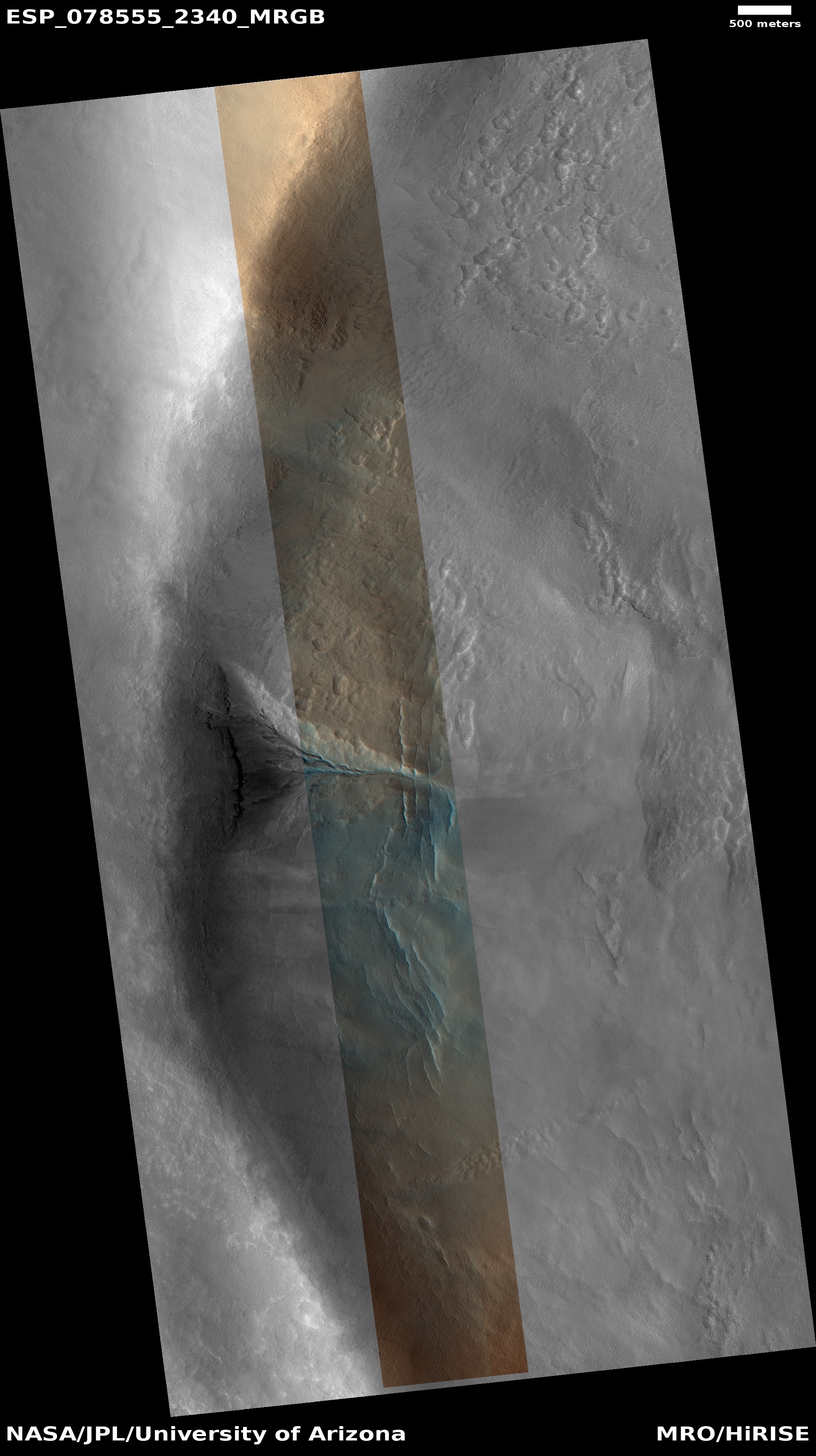
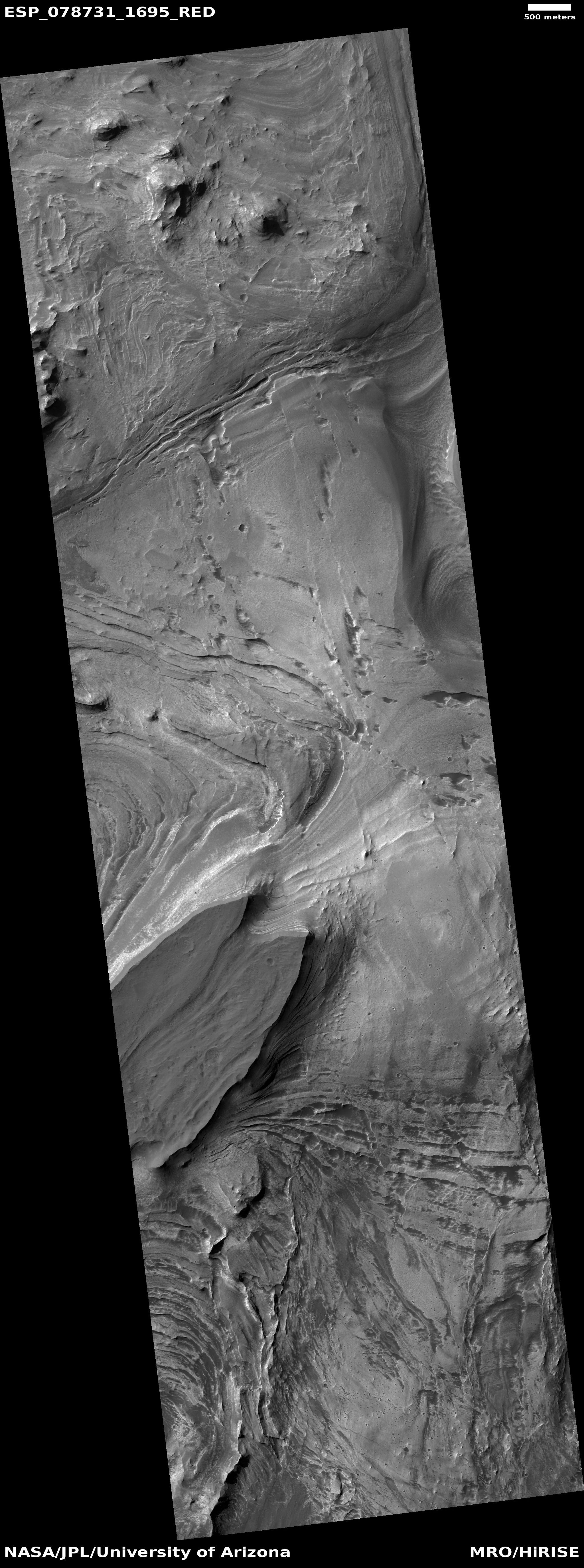
China’s state-run press today released two images taken by its Tianwen-1 Mars orbiter showing its Zhurong rover on the surface of Mars.

Those photos are to the right. The top shows the location prior to the rover’s landing. The bottom, taken on June 2nd, shows the rover and its landing platform, as well as its entry capsule, heat shield, and parachutes.

In the image, taken by a high-resolution camera installed on the orbiter of Tianwen-1 at 6 p.m. on June 2 (Beijing Time), two bright spots are visible in the upper right corner. The larger one is the landing platform, and the smaller one is the Zhurong Mars rover, the CNSA said.

…The dark area surrounding the landing platform might be caused by the influence of the engine plume during landing. The symmetrical bright stripes in the north-south direction of the landing platform might be from fine dust when the landing platform emptied the remaining fuel after landing, the CNSA said.

The bright spots in the center of the image are the back cover of the entry capsule and the parachute jettisoned during the landing. Another bright spot in the lower left of the image is the heat shield of the entry capsule, the CNSA said.

Based on the second photo, it appears that Zhurong has barely moved far from the lander since it rolled off on May 22nd.

And that’s all we really know. The Chinese press release provides no details about how well the rover is functioning, where exactly this location is on the surface of Mars, nor anything else of interest. The rover might be in the region covered by the MRO photos I posted yesterday, but if so the resolution isn’t good enough for me to find the spot. I am sure however that MRO scientists are presently carefully comparing their highest resolution version with these Tianwen-1 images to pinpoint it. They will then follow-up with their own high-resolution images of Zhurong from MRO.

The rover has a planned mission length of 90 Martian days, which runs through the end of August. How much the Chinese government will reveal about its operations and results however remains completely unknown. If it functions as planned expect science papers published in about a year. If not we will only get silence.

Mini-volcanoes (mud or lava?) near Zhurong’s Mars landing site

Mosaic of features near Zhurong's planned landing site on Mars
Click here, here, and here for full images.

Cool image time! Though we still do not know exactly where the Chinese Mars rover Zhurong landed on Mars, we have a rough idea based on the latitude and longitude numbers leaked to the Chinese press in October 2020 and were apparently confirmed by photos taken by the Tianwen-1 orbiter soon after reaching Mars. We also know Zhurong’s engineers wanted to land in the northern lowland plains dubbed Utopia Planitia, a region that is relatively flat and thus makes a safe landing spot for their first attempt to reach the surface of Mars.

The mosaic to the right, rotated and reduced to post here, is made from three context camera images taken by Mars Reconnaissance Orbiter (MRO). The white cross on the right edge is essentially Zhurong’s leaked landing spot. The red box indicates the area covered by one of only two photos that China has released that were taken by its Tianwen-1 orbiter.

The white box in the upper left shows the area covered by today’s cool image, shown below.
» Read more

Curiosity’s dramatic path forward

Curiosity's future travels
Click for full image.

Cool image time! In the coming weeks and months the view from Curiosity is going to give us the most spectacular views of another world since the Apollo astronauts walked on the Moon.

In today’s download of new images from the Mars rover Curiosity was the photo above, reduced to post here. Taken by rover’s right navigation camera, it looks west directly in line with Curiosity’s future travels, and shows that it is now finally entering mountain country.

The overview map below provides the context.
» Read more

1 26 27 28 29 30 74