Fresh washes on Mars?

Meandering fresh wash on Mars?
Click for full image.

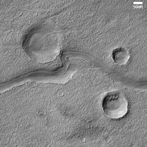
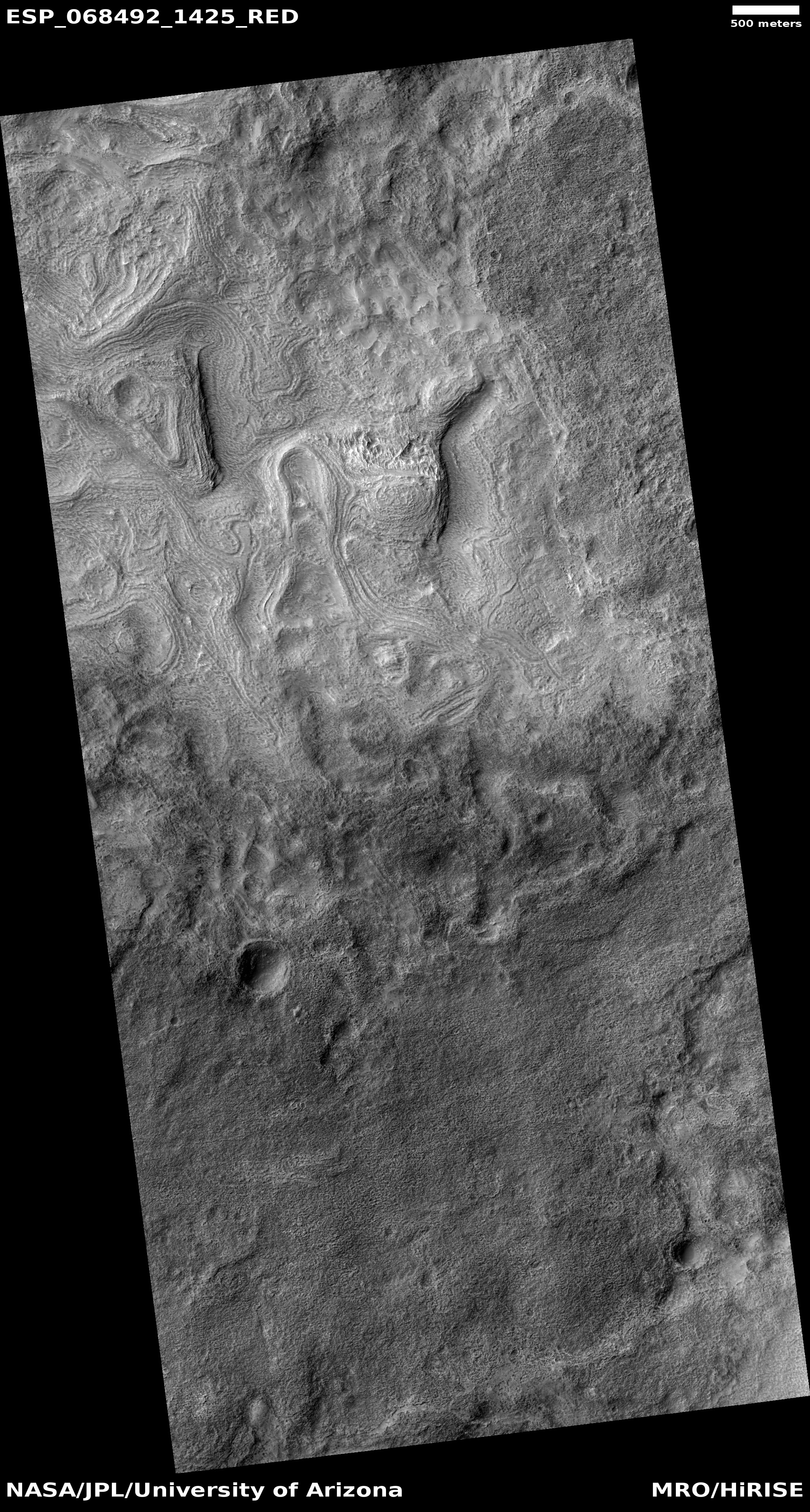
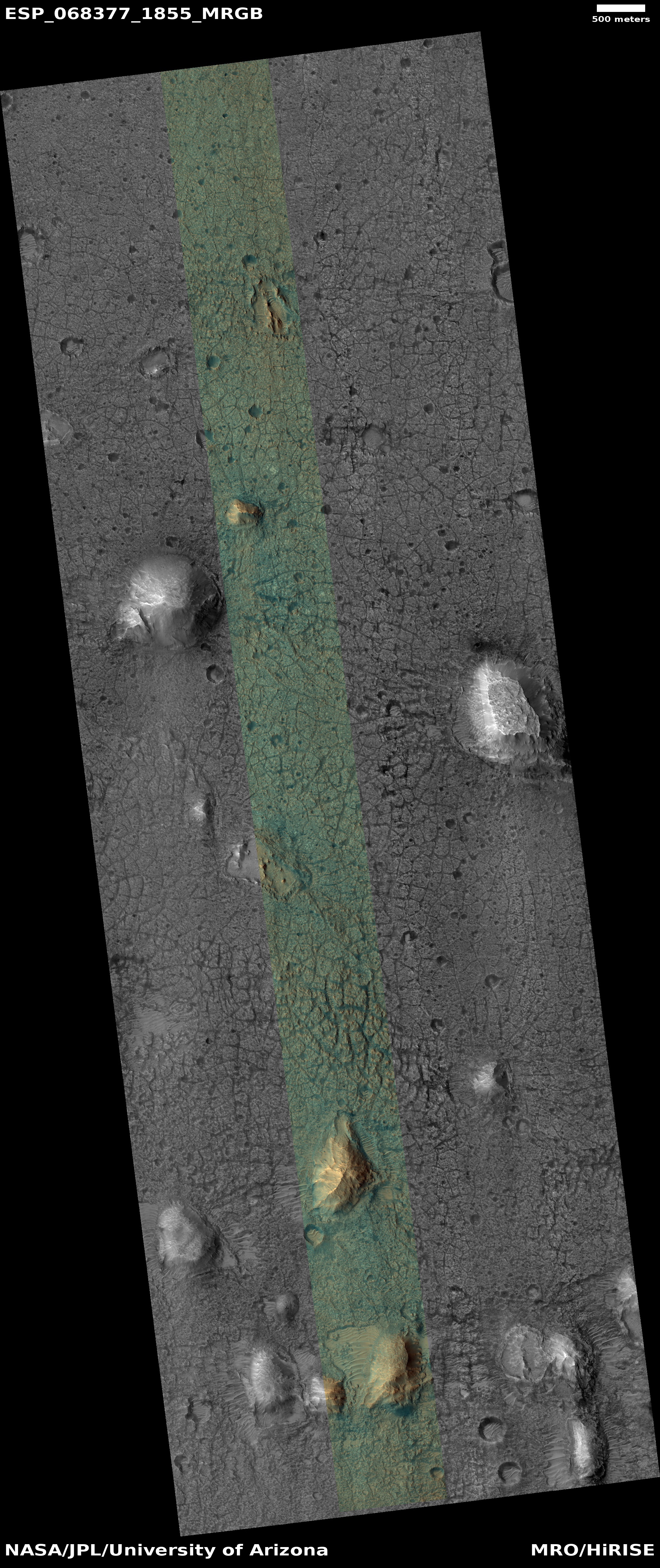
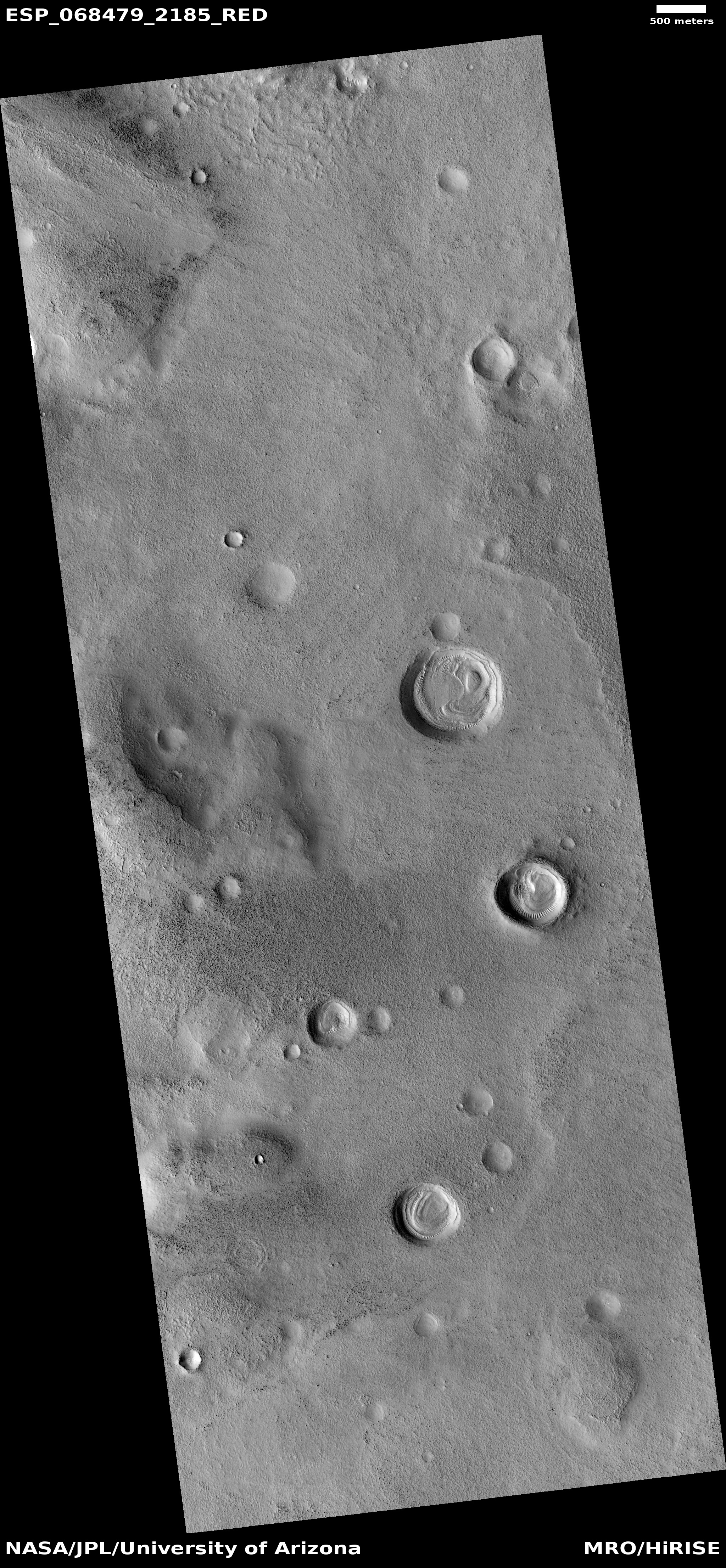
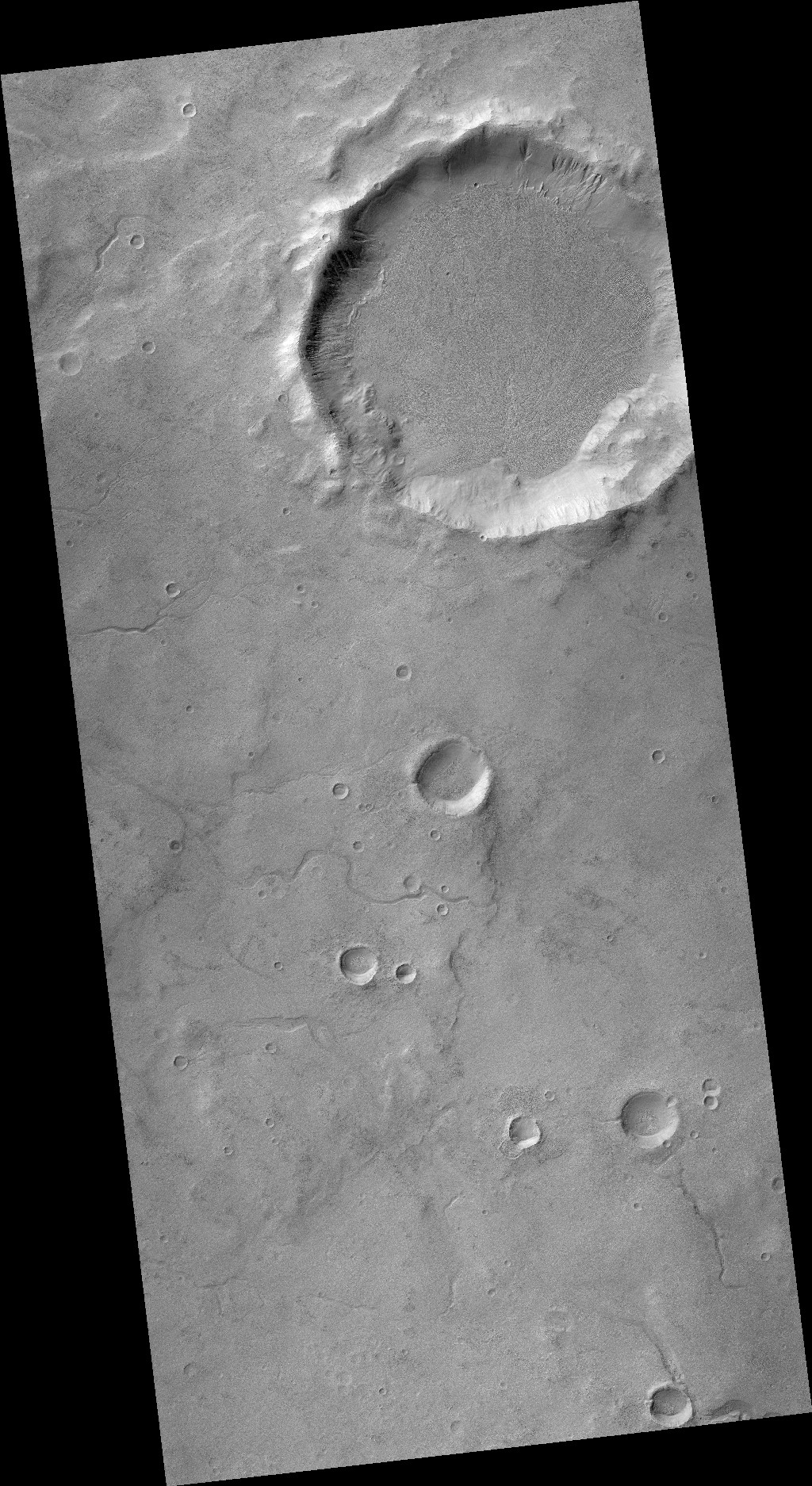
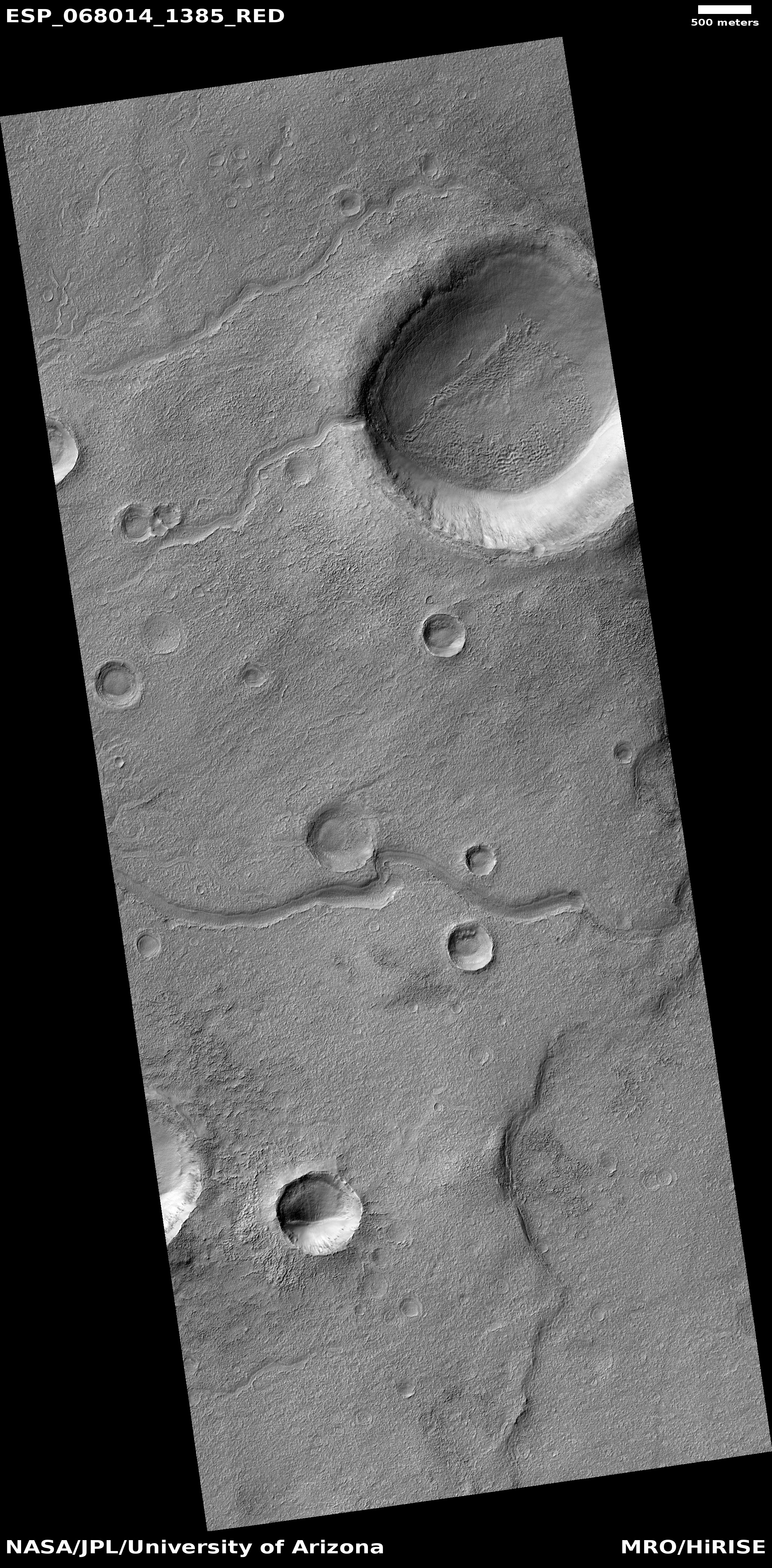
Cool image time! The photo to the right, cropped and reduced to post here, was taken on January 29, 2021 by the high resolution camera on Mars Reconnaissance Orbiter (MRO). It shows what the science team labels as “Fresh Shallow Valleys”. The section I have focused on shows a particularly interesting meander next to a small crater. The full image shows additional similar channels to the north, with one draining into a larger 3.7 mile wide crater.

The location is in the southern cratered highlands, at about 41 degrees south latitude, where much evidence of buried glacial features are found. That certainly is what we appear to see here. In fact, the wider view afforded by MRO’s context camera reveals many more such channels. That wider view also shows a much larger 18-mile-wide crater just to the north that appears filled with buried ice.

That the scientists label these fresh suggests they think they are relatively young, probably dating from when the most recent cycle of glacial growth probably ended. This would make them about 6 million years ago, based on this paper [pdf] and the second figure from that paper below.
» Read more

A river of lava on Mars as long as the Columbia

Lava flow in Kasei Valles
Click for full image.

I’ve said it before and I’ll say it again. Mars is strange, Mars is wonderful, but above all, Mars is alien. Today’s cool image illustrates this saying quite nicely.

The photo to the right, cropped and reduced to post here, was taken on February 1, 2021 by the high resolution camera on Mars Reconnaissance Orbiter (MRO) and was simply labeled “Sacra Sulci Lava”. Sacra Sulci is a section of the Kasei Valles canyon that runs from the north rim of Valles Marineris north about 600 miles where it turns east for about 400 miles to drain out into the northern lowlands plains of Mars. Sacra Sulci is the region where that valley narrows and then turns east.

Apparently the flat smoother areas on the east and south on this image that rise about 60 feet above the surrounding terrain and that also seem to flow around mesas and into canyons are believed to be the edge of a massive lava flow that occurred about 150 to 200 million years ago and drained through Kasei Valles, just like water.

What makes this puzzling, however, is that everything I had read previously about Kasei Valles said that it was thought to have been formed from catastrophic floods of water on early Mars, when the planet was warmer and wetter. In fact, I had posted previously about this theory, and included the map below, taken from figure 8 of this paper [pdf], showing part of the process that some scientists believe occurred.
» Read more

Ingenuity’s fourth flight today a success

Ingenuity's 4th flight
For original images, go here, here, here, and here.

As planned, Ingenuity took off early today on Mars at 12:33:20 pm (local Mars time). Data from the full flight has now arrived on Earth, with images that show the helicopter rising, moving about, and then landing. The montage above captures the part of the flight visible from one of Perservance’s cameras.

Apparently Ingenuity was in the air for about two minutes, and landed a bit to the right of its take-off point. We will have to wait for an update from the engineering team to find out exactly what happened.

UPDATE: Mimi Aung, the Ingenuity project manager, posted a report later today:

The helicopter took off at 10:49 a.m. EDT (7:49 a.m. PDT, or 12:33 local Mars time), climbing to an altitude of 16 feet (5 meters) before flying south approximately 436 feet (133 meters) and then back, for an 872-foot (266-meter) round trip. In total, we were in the air for 117 seconds.

The helicopter also took a lot of images, which they are presently in the process of downloading and reviewing.

Fourth flight of Ingenuity set for today; shifting to operational phase

Ingenuity close-up taken by Perseverance April 28th

Even as the Ingenuity engineering team will attempt a fourth flight of Ingenuity, JPL announced today that they and NASA have decided to now shift to operational flights, attempting to duplicate the kind of scouting missions that such helicopters will do on future rovers.

The second link takes you to the live stream of the press conference. The press release is here.

Essentially, they will send Ingenuity on a series of scouting missions after this fourth flight, extending its 30 day test program another 30 days. Its engineers will be working with the Perseverance science team to go where those scientists want to send it. After the fourth and fifth test flights they will fly Ingenuity only periodically, separated by weeks, and send it to scout places Perseverance can’t reach, and have it land at new sites that Perseverance scouted out as it travels.

They have decided to do this because they want to spend more time in this area on the floor of Jezero Crater, for several reasons. First, they are still testing the rover to get it to full working operations. Second, they want to obtain some samples for future pickup at this location. Third, they want to spend an extensive amount of time exploring the floor up to a mile south of their present location.

Finally, the relatively flat terrain is perfect for testing and actually using the helicopter as a scout.

Though the extension is for 30 days, and though the helicopter was not built for long term survival, there is no reason it cannot continue indefinitely until something finally breaks.

Right now they are awaiting the data from the fourth flight, which will arrive at 1:39 pm (Eastern) and will be used to determine what the fifth flight will do, probably a week from now.

Ingenuity fails to take off on 4th flight

When early today Ingenuity attempted to complete its fourth and most ambitious test flight on Mars the helicopter did not lift off, for reasons that engineers are still investigating.

[JPL] engineers are assessing the data, since it’s not yet clear what caused the failure. One potential cause is a software issue that first showed up during a high-speed spin test ahead of the chopper’s first flight. That test failed because Ingenuity’s flight computer was unable to transition from “pre-flight” to “flight” mode. Within a few days, though, [JPL] engineers resolved the issue with a quick software rewrite.

But those engineers determined that their fix would only successfully transition the helicopter into flight mode 85% of the time. So Thursday’s attempt may have fallen into the 15% of instances in which it doesn’t work.

This flight was supposed to fly south for about 430 feet, take pictures, and then return to its take-off point. If they can trouble-shoot the issue they hope to do another flight quickly. They still have a week left in their 30 day test period.

The crack that splits the giant volcanoes on Mars

Source of Arsia Mons rille
Click for full image.

Cool image time! In the April download of new images from the high resolution camera on Mars Reconnaissance Orbiter (MRO) was the photo to the right, taken on February 23, 2021 and cropped and reduced to post here, of what was labeled as “Source Region of Possible Rille on South Flank of Arsia Mons.”

Arsia Mons is the southernmost of the string of three giant volcanoes that sit between Mars’ biggest volcano to the west, Olympus Mons, and Mars’ biggest canyon to the east, Valles Marineris. This depression is on the mountain’s lower southern flank, and likely shows an ancient resurgence point where lava once flowed out from beneath the ground to form a rill meandering to the southwest. Today there is no visible resurgence. The floor of the depression appears to be filled with sand and dust, with the surrounding slopes spotted with scattered boulders.

What makes this particular image more interesting is how, when we take a very wide view, it reveals one of the most dramatic geological features on Mars, the 3,500 mile-long crack that caused these three volcanoes, and is actually not obvious unless you know what to look for.

So we need to zoom out. Let us first begin with a mosaic of three wider MRO context camera images, showing the entire rille and the immediately surrounding terrain.
» Read more

Ingenuity’s fourth flight today

The fourth flight of the Mars helicopter Ingenuity has just occurred, with data arriving momentarily.

The fourth Ingenuity flight from Wright Brothers Field, the name for the Martian airfield on which the flight took place, is scheduled to take off Thursday, April 29, at 10:12 a.m. EDT (7:12 a.m. PDT, 12:30 p.m. local Mars time), with the first data expected back at NASA’s Jet Propulsion Laboratory in Southern California at 1:21 p.m. EDT (10:21 a.m. PDT).

…Flight Four sets out to demonstrate the potential value of that aerial perspective. The flight test will begin with Ingenuity climbing to an altitude of 16 feet (5 meters) and then heading south, flying over rocks, sand ripples, and small impact craters for 276 feet (84 meters). As it flies, the rotorcraft will use its downward-looking navigation camera to collect images of the surface every 4 feet (1.2 meters) from that point until it travels a total of 436 feet (133 meters) downrange. Then, Ingenuity will go into a hover and take images with its color camera before heading back to Wright Brothers Field.

Stay tuned for new images. NASA will also hold a press conference tomorrow to outline the results and the rest of Ingenuity’s test program.

Twisted taffy in the basement of Mars

Taffy on Mars
Click for full image.

Cool image time! The photo to the right, taken on March 7, 2021 by the high resolution camera on Mars Reconnaissance Orbiter (MRO) and cropped and reduced to post here, shows us an example of one of Mars’ strangest and most puzzling geological features, dubbed banded or “taffy-pull” terrain by scientists.

Taffy-pull terrain has so far only been found within Hellas Basin, Mars’ deepest impact basin and what I like to call the basement of Mars. Because of the lower crater count in this terrain scientists consider it relatively young, no more than 3 billion years old, according to this 2014 paper, which also notes

The apparent sensitivity to local topography and preference for concentrating in localized depressions is compatible with deformation as a viscous fluid.

At the moment what that viscous fluid was remains a matter of debate. Many theories propose that ice and water acting in conjunction with salt caused their formation, similar to salt domes seen on Earth. Other propose that the terrain formed from some kind of volcanic or impact melt process.

Almost all of the taffy terrain on Mars has been found in the deepest parts of Hellas Basin in a curved trough along its western interior, as shown by the light blue areas in the overview map below.
» Read more

Perseverance as seen by Ingenuity

Perserverance as seen by Ingenuity
Click for full image.

Cool image time! JPL today released the photo to the right, cropped to post here. It was taken by the helicopter Ingenuity during its third flight on April 25th and shows the rover Perseverance at its left edge.

The horizon is tilted because the camera lens is very wide angle to capture as much terrain as possible and thus produces a fisheye curved distortion to the image’s periphery.

This image was taken as Ingenuity flew north about 160 feet away from Perseverance, probably in the first part of its flight as seen by photos taken by Perseverance of Ingenuity during its flight.

The mountains in the distance are the rim of Jezero Crater.

Martian pit on top of Martian dome

Dome with pit
Click for full image.

Cool image time! The photo to the right, cropped and reduced to post here, was taken on March 7, 2021 by the high resolution camera on Mars Reconnaissance Orbiter (MRO) and was simply labeled “Pit on Top of Dome in Promethei Terra.”

The cropped section to the right shows one of two such pits visible on the entire image. Promethei Terra is a large 2,000 mile long cratered region due east from Hellas Basin, the deepest large region on Mars.

What caused these pits? The known facts provide clues, but do not really solve the mystery.

First, this image is located in the southern cratered highlands at 45 degrees south latitude. Thus, it is not surprising that it resembles similar terrain in the northern lowlands that suggests an ice layer very close to the surface.
» Read more

Study: increase in seasonal Martian streaks after 2018 global dust storm suggests dust not water is their cause

Map of Mars showing location of new linneae after 2018 global dust storm
Click for full image.

The uncertainty of science: A just-published survey of Mars following the 2018 global dust storm found that there was a significant increase in the seasonal dark streaks that scientists call recurring slope lineae, providing more evidence that these streaks are not caused by some form of water seepage but instead are related to some dry process.

The map to the right is figure 2 from that paper. The white dots show the candidate lineae that appeared following the 2018 global dust storm. About half were new streaks, not seen previously.

From the paper’s conclusion:
» Read more

Ingenuity completes third flight!

Low resolution montage showing Ingenuity's third flight on Mars, April 25, 2021
Click for full resolution. Individual images can be found, in sequence, here, here, here, and here.

Early today Ingenuity successfully completed its third flight on Mars, traveling a considerable distance north from its taken-off point and then returning almost exactly to that point, as shown by the montage of four Perseverance navigation images above.

You will want to look at the high resolution montage, as the details are much clearer. The large mountains in the background are the rim of Jezero Crater. The smaller plateau in front of these mountains and much closer is the edge of the delta that Perseverance will explore.

According to this NASA press release:

The helicopter took off at 4:31 a.m. EDT (1:31 a.m. PDT), or 12:33 p.m. local Mars time, rising 16 feet (5 meters) – the same altitude as its second flight. Then it zipped downrange 164 feet (50 meters), just over half the length of a football field, reaching a top speed of 6.6 feet per second (2 meters per second).

I have embedded below the fold video of the helicopter’s take off, flight to the north, and then return and landing, created from Perseverance images. Because the camera did not pan the helicopter moves off frame for the middle part of its flight. In the coming days I expect they will assemble a video showing the entire flight.

The fourth flight is now only days away.
» Read more

Curiosity’s mesa-top view of Gale Crater

The view of Gale Crater from on top of Mont Mercou
Click for full image.

Cool image time! The photo above, reduced slightly to post here, was taken on April 14, 2021 by one of the navigation cameras on Curiosity. The rover was then and is still sitting on top of the twenty foot high outcrop dubbed Mont Mercou.

Last week I had posted a panorama made from images at this viewpoint looking south towards Mount Sharp. Today’s image is from the same place, but now looks north across the floor of Gale Crater at the areas that Curiosity had previously traveled. I think the smallest mesas on the left of this image are the Murray Buttes which Curiosity was traveling through back in 2016, but am not certain.

The mountains in the far distance are the rim of the crater, about 30 miles away.

China names its Mars rover Zhurong, after traditional fire god

The new colonial movement: The Chinese state-run press today announced that it has chosen Zhurong, a traditional Chinese fire god, as the name of the rover that is presently orbiting Mars on its Tianwen-1 orbiter and is targeting a landing sometime in mid-May.

They note that this name matches well with the Chinese name for Mars, “Huo Xing,” or fire star.

The announcement provided little additional information, other than stating that the prime landing site is in the previously announced Utopia Planitia region, which suggests the high resolutions images being taken by Tianwen-1 (unreleased by China) continue to show no reason to change that target.

Ingenuity’s third flight late tonight

First color image from Ingenuity
Click for full image.

According to Håvard Grip, Ingenuity’s Mars Helicopter Chief, the helicopter’s team is now targeting very early Sunday morning for its third test flight.

For the third flight, we’re targeting the same altitude [as flight two], but we are going to open things up a bit too, increasing our max airspeed from 0.5 meters per second to 2 meters per second (about 4.5 mph) as we head 50 meters (164 feet) north and return to land at Wright Brothers Field. We’re planning for a total flight time of about 80 seconds and a total distance of 100 meters (330 feet).

While that number may not seem like a lot, consider that we never moved laterally more than about two-pencil lengths when we flight-tested in the vacuum chamber here on Earth. And while the 4 meters of lateral movement in Flight Two (2 meters out and then 2 meters back) was great, providing lots of terrific data, it was still only 4 meters. As such, Flight Three is a big step, one in which Ingenuity will begin to experience freedom in the sky.

The picture above was the first color image sent down by Ingenuity, taken during the second test flight when the helicopter was seventeen feet in the air and pitched slightly so that it could look east, toward Perseverance. From the caption:

The winding parallel discolorations in the surface reveal the tread of the six-wheeled rover. Perseverance itself is located top center, just out frame. “Wright Brothers Field” is in the vicinity of the helicopter’s shadow, bottom center, with the actual point of takeoff of the helicopter just below the image. A portion of the landing pads on two of the helicopter’s four landing legs can be seen in on the left and right sides of the image, and a small portion of the horizon can be seen at the upper right and left corners.

The data from tonight’s flight will arrive on Earth at around 7:16 am (Pacific) tomorrow.

Polygons and an inexplicable depression in ancient Martian crater floor

Polygons and an inexplicable depression in ancient Martian crater
Click for full image.

Cool image time! The photo to the right, cropped to post here, was taken on February 26, 2021 by the high resolution camera on Mars Reconnaissance Orbiter (MRO) of a small section of the floor of 85-mile-wide Galilaei Crater.

The main focus of the image is the polygonal cracks that cover the flat low areas of the crater floor, interspersed randomly by small mesas and shallow irregular depressions. The depression in this particular image is especially intriguing. It to me falls into my “What the heck?!” category, for I can’t imagine why among this terrain of polygons and pointed mesas there should suddenly be an irregularly shaped flat depression with a completely smooth floor that has no cracks at all.

The polygons are less puzzling. Galilaei Crater is very old, its impact thought to have occurred about 4 billion years ago. Though it sits at 5 degrees north latitude, practically on the Martian equator and thus in what is now Mars’ most arid region, scientists believe that once there was a lot of liquid surface water here. The overview map below illustrates this.
» Read more

Gale Crater’s small mesas were formed by wind, not liquid water

Route through Murray Buttes
The Murray Buttes. Click to see August 11, 2016 post.

The uncertainty of science: Though Curiosity has found apparent evidence of past liquid water during its early travels on the floor of Gale Crater, scientists have now concluded that the first small mesas and buttes it traveled past back in 2016, dubbed the Murray Buttes, were not formed by the flow of liquid water but by wind reshaping ancient sand dunes. From the press release:
» Read more

Bumps and holes in the Martian mid-latitudes

Bumps and holes in the Martian mid-latitudes
Click for full image.

Today’s cool image to the right, taken on January 6, 2021 by the high resolution camera on Mars Reconnaissance Orbiter (MRO) and cropped and reduced to post here, focuses on what appears to be a volcanic bulge on the southeastern edge of the great Tharsis Bulge, home to Mars’ biggest volcanoes.

The terrain gives the appearance of hard and rough lava field, ancient and significantly scoured with time. The bumps and mounds suggest nodules that remained as the surrounding softer material eroded away. The holes suggest impact craters, but their relatively few number suggest that this ground was laid down in more recent volcanic events after the late heavy bombardment that occurred in the early solar system about 4 billion years ago. Since it is thought that the big Martian volcanoes stopped being active about a billion years ago, this scenario seems to fit.

However, the terrain also has hints of possible glacial features, as seen in the large crater-like depression in the image’s center. Below is a zoom in to that crater to highlight the flowlike features in its southern interior.
» Read more

First images of Ingenuity’s second flight

Ingenuity's second flight, April 22, 2021
For full images go here, here, and here.

According to Mimi Aung, the project manager for Ingenuity, they attempted their second flight of the Mars helicopter early this morning, with the following flight plan:

[W]e plan to trying climbing to 16 feet (5 meters) in this flight test. Then, after the helicopter hovers briefly, it will go into a slight tilt and move sideways for 7 feet (2 meters). Then Ingenuity will come to a stop, hover in place, and make turns to point its color camera in different directions before heading back to the center of the airfield to land. Of course, all of this is done autonomously, based on commands we sent to Perseverance to relay to Ingenuity the night before.

No live stream was provided this time. However, the three images above from Perseverance, just downloaded today and taken about nine minutes apart, show Ingenuity before, during, and after that flight. If you compare the first and third images you can see that the helicopter was able to successfully return to the same landing spot.

I expect an announcement of this successful flight to be posted shortly.

UPDATE: JPL has now released an image taken by Ingenuity during its flight.

Perseverance technology experiment produces oxygen from Mars’ atmosphere

An engineering test experiment dubbed MOXIE on the Perseverance rover has successfully produced oxygen from the carbon dioxide in the Martian atmosphere, a technology that will be essential for future human missions.

MOXIE (Mars Oxygen In-situ Resource Utilization Experiment), a small, gold box-shaped instrument on the rover, successfully demonstrated a solid oxide electrolysis technology for converting the Martian atmosphere to oxygen. The atmosphere on Mars is about 95% carbon dioxide.

MOXIE’s first oxygen run produced 5.4 grams of oxygen in an hour. The power supply limits potential production to 12 g/hr — about the same amount that a large tree would produce.

…The oxygen production process starts with carbon dioxide intake; inside MOXIE, the Martian CO2 is compressed and filtered to remove any contaminants. It is then heated, which causes separation into oxygen and carbon monoxide. The oxygen is further isolated by a hot, charged ceramic component; the oxygen ions merge into O2. Carbon monoxide is expelled harmlessly back into the atmosphere.

Human missions to Mars will not just need oxygen to breath. They will need it to provide the fuel for leaving the planet and returning to Earth, since it will be very impractical and expensive to bring everything they need with them. For colonization and planetary exploration to truly happen future space-farers must live off the land.

Glacial layers in a northern crater on Mars

Crater filled with many layered glacial features
Click for full image.

Cool image time! The photo to the right, cropped to post here, was taken by the high resolution camera on Mars Reconnaissance Orbiter on March 6, 2021, and shows a mid-latitude crater in the northern lowland plains of Mars with what appear to be layered glacial features filling its interior.

The theory that scientists presently favor for explaining many of the features we see on Mars is based on many climate cycles caused by the wide swings the planet routinely experiences in its obliquity, or rotational tilt. When that tilt is high, more than 45 degrees, the mid-latitudes are colder than the poles, and water ice sublimates southward to those mid-latitudes to fall as snow and cause active glaciers to form. When that obliquity is low, less than 20 degrees, the mid-latitudes are warmer than the poles and that ice then migrates back north.

Such cycles, which are believed to have occurred many thousands of times in the last few million years, will place many layers on the ground in both the mid-latitudes and at the poles. The layers in this crater hint at this.

The overview map below gives some further context.
» Read more

Four more flights for Ingenuity in the next eleven days.

According to MiMi Aung, Ingenuity’s project manager, the test flight campaign for the Mars helicopter Ingenuity has only about eleven days left, during which they will try to complete full flight program of four more test flights.

The helicopter’s one-month test flight campaign officially began April 3, then the Perseverance rover deployed Ingenuity onto the surface of Mars. “We have a 30 day experiment window, so we have two weeks left,” said MiMi Aung, Ingenuity’s project manager at NASA’s Jet Propulsion Laboratory in California.

She said the helicopter will attempt “increasingly bolder flights” that could travel more than 2,000 feet (600 meters) from its takeoff location. “We do want to push it, and I believe we have enough time to squeeze the next four flights in the next two weeks left.”

The second flight, where the helicopter will go up about 16 feet and then move sideways about seven feet before landing at its take-off point, could happen tomorrow. The third flight, which will travel as much as 150 feet, will follow soon thereafter.

Video of Ingenuity’s flight, taken by Perseverance

JPL yesterday released a short one minute long video created from images taken by the high resolution mast camera on Perseverance.

You can view the animation here.

Stitched together from multiple images, the mosaic is not white balanced; instead, it is displayed in a preliminary calibrated version of a natural-color composite, approximately simulating the colors of the scene as it would appear on Mars.

Spring arrives on the northern polar cap of Mars

Buzzell dunes and pedestal crater near the Martian north polar ice cap
Click for full image.

Cool image time! It is now spring in the northern hemisphere of Mars, and the first bits of sunlight are finally reaching its north polar ice cap. During the winter, as happens each Martian year, that polar cap of water ice gets covered by a thin mantle of dry ice no more than six feet thick. Moreover, this mantle doesn’t just cover the ice cap, it extends south as far as about 60 degrees latitude, covering the giant sea of dunes that surrounds the ice cap.

When spring comes that mantle begins sublimate away, with its base first turning to gas. When the pressure builds up enough, the gas breaks out through the frozen mantle’s weakest points, usually the crest or base of dunes or ridges, leaving behind a dark splotch caused by the material thrown up from below that contrasts with the bright translucent dry ice mantle.

Each year for the past decade scientists have been using the high resolution camera on Mars Reconnaissance Orbiter (MRO) to monitor this sublimation process. The photo above, taken on February 24, 2021 and cropped, enlarged, and brightened to post here, marks the start of this year’s monitoring program. Dubbed informally “Buzzell” by Candice Hansen of the Planetary Science Institute in Arizona, it shows dunes with a round pedestal crater just right of center. Though almost everything when this picture was taken is still covered by that dry ice mantle, in the lower left is a single splotch, the first breakout of CO2 gas that marks the beginning of the annual disappearance of this dry ice.

Last Martian year I repeatedly posted images of Buzzell to illustrate this annual process. The second image below was taken on April 4, 2019, at about the same comparable time in spring.
» Read more

Ingenuity flies!

Ingenuity takes off!
For full images go here and here.

The first autonomous flight of the helicopter Ingenuity on Mars successfully took place early this morning, according to JPL engineers.

NASA has pulled off the first powered flight on another world. Ingenuity, the robot rotorcraft that is part of the agency’s Perseverance mission, lifted off from the surface of Mars on 19 April, in a 40-second flight that is a landmark in interplanetary aviation. “We can now say that human beings have flown a rotorcraft on another planet,” says MiMi Aung, the project’s lead engineer at the Jet Propulsion Laboratory (JPL) in Pasadena, California.

As shown by the two images taken by Perseverance above, the first flight was very simple. The helicopter simply rose about 10 feet, hovered for about 30 seconds as it swiveled 90 degrees, and then carefully descended back down. I have also embedded the video that JPL scientists have created compiling by high resolution Perseverance images below the fold.

Four more flights will next be attempted in the coming weeks.

Four further flights, each lasting up to 90 seconds, are planned in the coming weeks. In these, Ingenuity is likely to rise up to 5 metres [16 feet] above the surface and travel up to 300 metres [1000 feet] from the take-off point. Each successive flight will push Ingenuity’s capabilities to see how well the drone fares in Mars’s thin atmosphere, which is just 1% as dense as Earth’s.

» Read more

The rovers’ view of Mars

The view from the top of Mont Mercou
Click for higher resolution. For original images, go here and here.

Some cool images to savor from Mars! Above is a panorama from Curiosity, created by me from two images taken by the rover’s left navigation camera today, April 18, 2021. The view is southwest towards the canyon regions where Curiosity will be heading in the coming months. Note the roughness of the ground. Travel is going to be tricky from here on out.

The photo was taken from the top of Mont Mercou, the 20-foot high outcrop that the rover spent several weeks studying at the cliff’s base. The Curiosity science team is presently preparing to drill into the bedrock at the top.

Ingenuity on the floor of Jezero Crater
Click for full image.

The photo to the right, reduced to post here, was taken by Perseverance on April 13, 2021, and looks west across the floor of Jezero crater. The high mountains in the distance are the crater’s rim. The low and much closer hill is the delta that is the rover’s primary geological target.

In the center of the picture is the helicopter Ingenuity. You can also see the tracks of Perseverance’s wheels just below it.

This will be the rover’s vantage point when Ingenuity attempts its first test flight in the early morning hours of April 19, 2021. The helicopter will head to the right once it lifts off.

Ingenuity first test flight scheduled for 3:30 am (Eastern) tonight!

The engineering team for the Ingenuity helicopter on Mars have decided to attempt the first test flight tonight, scheduled for 3:30 am (Eastern) in the early morning hours tomorrow.

Data from the first flight will return to Earth a few hours [later] following the autonomous flight. A livestream will begin at 6:15 a.m. EDT (3:15 a.m. PDT) as the helicopter team prepares to receive the data downlink in the Space Flight Operations Facility at NASA’s Jet Propulsion Laboratory (JPL).

NASA propaganda will begin on NASA TV at 3:30 am (Eastern), but the actual live stream of the flight will not air until about 6:30 am (Eastern) on April 19th.

At the first link above the engineers explain their decision to proceed immediately.
» Read more

Ingenuity successfully completes rapid spin test

Ingenuity’s engineers announced this morning that yesterday the helicopter on Mars was able to successfully complete a rapid spin test of its rotary blades.

Today, April 16, on the 154th anniversary of Wilbur Wright’s birth, the Ingenuity flight team received information that the helicopter was able to complete a rapid spin test. The completion of the full-speed spin is an important milestone on the path to flight as the team continues to work on the command sequence issue identified on Sol 49 (April 9).

…The approach that led to today’s successful spin test entailed adding a few commands to the flight sequence. This approach was tested extensively on both Earth and Mars, and was performed without jeopardizing the safety of the helicopter.

They have still not set a date for flight, because they might still decide, after they have analyzed fully the results from this test, to revise the helicopter’s software and upload that change. If not the flight will be relatively soon. If so there will be a longer delay to test that software fully before flight.

InSight pauses science operations to conserve power

The science team for the InSight lander on Mars have been forced to suspend science operations because dust on the solar panels is reducing the available power.

InSight’s solar panels were producing just 27% of their energy capacity in February, when winter was arriving in Elysium Planitia. So NASA decided to start incrementally turning off different instruments on the lander. Soon the robot will go into “hibernation mode,” shutting down all functions that aren’t necessary for its survival.

By pausing its scientific operations, the lander should be able to save enough power to keep its systems warm through the frigid Martian nights, when temperatures can drop to negative-130 degrees Fahrenheit. “The amount of power available over the next few months will really be driven by the weather,” Chuck Scott, InSight’s project manager, said in a statement.

InSight is still in good condition – it’s even using its robotic arm – but the risk of a potentially fatal power failure is ever-present. If the lander’s batteries die, it might never recover.

As with the rovers Spirit and Opportunity, InSight engineers have depended on periodic strong wind events to periodically clean off the solar panels. Unfortunately, these events are somewhat random, and for the past few months none have occurred.

Note: the article at the link says that winter was arriving at InSight’s location in February, but this is incorrect. InSight sits at about 4 degrees north latitude. In February the end of winter was approaching in the northern hemisphere. More to the point, sitting at the equator you wouldn’t really expect InSight to experience much seasonal changes regardless.

It therefore seems that these issues had less to do with the seasons and much more to do with the accumulating dust on the panels.

Evidence of glaciers in the Martian equatorial regions?

Equatorial crater with glacial features?

Cool image time! The photo to the right, cropped and reduced to post here, was taken on February 2, 2021 by the high resolution camera on Mars Reconnaissance Orbiter (MRO) and was labeled as “Exhumed Craters Exhibiting Concentric Fill”.

The term “Concentric Fill” is used by planetary scientists to mark glacial-type features frequently found inside craters at latitudes greater than 30 degrees latitude. This crater however is at 22 degrees north latitude, too close normally to the equator to expect a buried glacier inside it. Any ice at such a latitude is expected to be underground and well protected. A debris covered glacier would likely sublimate away, which I think is why the scientists labeled this “exhumed.” Though there are the concentric features near its inside rim as well as covered by the sand dunes on the crater’s floor, they are assuming this is only evidence of past ice, no longer there. This assumption is strengthened by the splattered but eroded nature of the surrounding terrain. Such splats are typical of high latitude impacts in regions with ample buried ice. The eroded nature of this splat however suggests it is very old and has likely lost its ice.

Then again, this is an assumption.
» Read more

1 28 29 30 31 32 74