Curiosity sends its first images in two weeks

The computer problems that caused Curiosity to cease science operations two weeks ago appears to have ended with the arrival of the first new images today.

The second link above goes to the images arriving today from Curiosity’s ChemCam camera, designed to take macro images of small features on the surface. The rover also sent down a small set of thumbnail images taken by one of its navigation cameras.

It appears they have figured out why the computer did an unexpected reboot in mid-February, and are now willing to let the rover resume science operations. There is no word on what they have learned, or whether it poses a future threat to the mission, but the fact that they are downloading new data is a good sign.

I must note again that this is news you will not see anywhere else. Most news sources today will wait for the NASA press release to report on Curiosity’s recovery, while I like to do some real journalism, reporting events as they happen. Consider this another reason to donate to Behind the Black during this month’s fund-raising drive.

Planet-wide groundwater system on Mars

Old news: The European Space Agency today released a press release announcing the results of a science paper that appears to have found evidence of a planet-wide groundwater system on Mars.

I call this old news because I reported on this paper a month ago here on Behind the Black: Well water likely available across Mars.

We are now near the end of my February birthday-month fund-raising drive. If anything should justify a donation or subscription, this story should provide it. You can either wait for the mainstream press to rewrite press releases, or you can support my effort to get real news to you now, reported with both enthusiasm and honest skepticism.

I really do hate to brag, but I also don’t believe in false modesty.

ExoMars prototype test driven from 6,000 miles away

The engineering team that will drive ExoMars 2020 on the surface of Mars in 2021 has completed a test drive using an engineering prototype, controlling it from more than 6,000 miles away.

Experts at the European Space Agency’s centre in Oxfordshire completed a series of tests across nearly 6,900 miles (11,000 km) in order to see how the Mars rover reacts to commands across large distances.

When on the surface of Mars, the rover will need to be controlled when it is up to 250 million miles from Earth.

The trials team used a new model called ‘Charlie’ to test hardware, software and to practice science operations for the future European Space Agency (ESA) ExoMars rover, which will look for life on Mars in 2021. The Atacama desert was chosen because it is the closest we can get to a Martian-like environment.

I must admit that every press release from Europe about ExoMars 2020 gives me worried chills. Each release is often filled too much with empty boasts and little substantive detail. Worse, each seems to repeatedly remind me of some guy working in his garage on a weekend project.

The issue could merely be a case of poor press release writing, but something about each release makes these alarm bells go off in the back of my mind. With the launch only about sixteen months away, I hope I am wrong.

Waterlike Martian lava flows

Flowing like water
Click for full image.
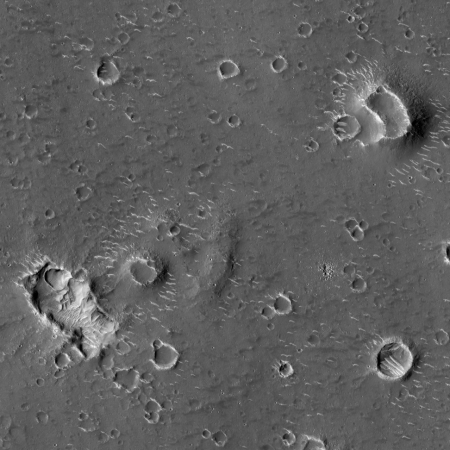
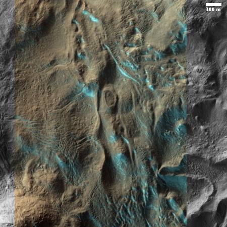
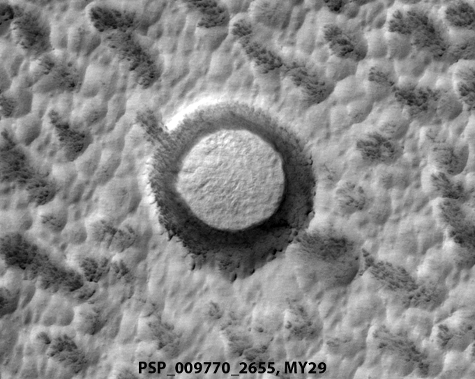
Each month the Mars Reconnaissance Orbiter (MRO) science team highlights with captions about four out of the 300-500 new images released that month.

Of the four captioned images in February, the first was entitled “Almost Like Water,” and focused on the waterlike nature of the lava flow. The image on the right is a cropped and annotated section of that featured photograph, with the yellow arrows indicating the flow directions.

The lava appears to have flowed smoothly around obstructions, almost like water, forming streamlined islands. In the southern part of this image, a branch of the flow diverts around a small crater, and eventually rejoins the main part of the flow. [Visible in the full photograph] Irregular-shaped ring structures appear on the northern end and are related to the volcanic activity that formed the flows.

You can see an example of one of those islands near the top of the above image.

This is hardly the only MRO image showing such flows. In fact, the February image release included a bunch, some of the more intriguing of which I highlight below. These lava flows are seen in many different places on Mars, in a wide variety of geological settings, facts that suggest that volcanic activity was once very widespread and ubiquitous on Mars.
» Read more

No laser communications system at Tabby’s Star

If alien megastructures exist at Tabby’s Star, new research has precluded the likelihood that those aliens are using lasers for communications within those gigantic structures.

[The scientists checked] for laser signatures, on the not unreasonable grounds that any structure large enough to encase a star – Boyajian [Tabby’s Star] is almost one-and-a-half times the mass of the sun – would have an internal communication system, for which lasers would represent a good candidate medium.

In the latest research, Lipman and colleagues decided to test the idea. They analysed 177 high-resolution spectra from the star, gathered by the Lick Observatory’s Automated Planet Finder telescope as part of the Breakthrough Listen Project. They estimated that the data was so detailed that lasers with power greater than 24 megawatts should show up. To hunt for them, the researchers developed an algorithm to perform a pixel-by-pixel analysis of each spectrum in order to identify “spatially unresolved emission lines that meet the criteria for an artificial laser signal”.

The good news is that they found several. The bad news is that a secondary multi-step analysis designed to pick up false positives discounted them all. “The top candidates from the analysis can all be explained as either cosmic ray hits, stellar emission lines or atmospheric air glow emission lines,” they conclude.

We must remember that alien megastructures are the most unlikely explanation for the random light fluctuations of Tabby’s Star. This research helps to strengthen that conclusion.

Bad climate science, bad climate journalism

The coming dark age: It appears that the most fundamental concept of science, that all research is subject to skepticism, questioning, and doubt, is no longer followed by the world’s leading science journal Science, in either the research or journalism it publishes.

In reporting today how the Trump administration is establishing a climate review panel that will include global warming skeptics, this so-called science journal describes this effort as follows:

The White House is recruiting researchers who reject the scientific consensus on climate change for its “adversarial” review of the issue.

The proposal to form a “Presidential Committee on Climate Security” at the National Security Council (NSC) has shifted, into an ad-hoc group that will review climate science out of the public eye. Those involved in the preliminary discussions said it is focused on recruiting academics to conduct a review of the science that shows climate change presents a national security risk.

William Happer, a senior director at the NSC and an emeritus Princeton University physics professor not trained in climate science, is leading the effort.

Among those who have been contacted are the relatively small number of researchers with legitimate academic credentials who question the notion that humans are warming the planet at a rapid pace through the burning of fossil fuels. A number of the names the White House is targeting are those frequently invited by Republicans to testify at congressional hearings on climate change where uncertainty is emphasized.

The stated goal of the committee, according to a leaked White House memo, is to conduct “adversarial scientific peer review” of climate science. [emphasis mine]

The article also stated that the panel “will also include scientists who agree with the vast majority in the field of climate science that humans are warming the planet at a pace unprecedented in the history of civilization.”

First of all, it is not clear that “a vast majority in the field of climate science” agree with that global warming hypothesis. And even if it was, it would not matter. Science isn’t determined by consensus or majority rule. It is determined by facts, and if the facts don’t support the beliefs of 97% of all climate scientists, all 97% of those scientists are wrong. That this writer and the editors at Science don’t understand this is shocking.
» Read more

Hayabusa-2 touchdown images released

Surface of Ryugu 1 minute after touchdown

The Hayabusa-2 science team today released images taken during its quick touchdown on the asteroid Ryugu last week.

The image to the right was taken:

roughly 1 minute after touchdown at an estimated altitude of about 25m (error is a few meter) [80 feet]. The color of the region beneath the spacecraft’s shadow differs from the surroundings and has been discolored by the touchdown. At the moment, the reason for the discoloration is unknown but it may be due to the grit that was blown upwards by the spacecraft thrusters or bullet (projectile).

The image proves that everything on Hayabusa-2 worked as planned, and it almost certainly captured some of that grit.

They are going to do at least two more touchdowns before they have Hayabusa-2 leave Ryugu and head back to Earth.

Most popular theorized particle for explaining dark matter now eliminated

The uncertainty of science: The WIMP particle (Weakly Interacting Massive Particle), the most popular theorized particle to explain dark matter, has now been eliminated by experiments.

These experiments have now been ongoing for decades, and have seen no dark matter [WIMPs].

…Theorists can always tweak their models, and have done so many times, pushing the anticipated cross-section down and down as null result after null result rolls in. That’s the worst kind of science you can do, however: simply shifting the goalposts for no physical reason other than your experimental constraints have become more severe. There is no longer any motivation, other than preferring a conclusion that the data rules out, in doing.

Other theorized but less favored particles could still be proved to be dark matter, but the problem is getting harder and harder to solve, as presently assumed.

Dark matter has always been an invention created to explain the too-fast orbital velocities of stars in the other regions of galaxies. It could very well be however that the problem comes not from new physics and a newly contrived particle we can’t see, but from a deficiency in our overall observations of galaxies and what is there, within the constraints of the physics we know now.

Hat tip Mike Buford.

New high resolution images of Ultima Thule

Highest resolution image of Ultima Thule
Click for full resolution image.

The New Horizons team has released new high resolution images of Ultima Thule, taken during its fly-by on January 1, 2019.

These new images of Ultima Thule – obtained by the telephoto Long-Range Reconnaissance Imager (LORRI) just 6½ minutes before New Horizons’ closest approach to the object (officially named 2014 MU69) at 12:33 a.m. EST on Jan. 1 – offer a resolution of about 110 feet (33 meters) per pixel.

…The higher resolution brings out a many surface features that weren’t readily apparent in earlier images. Among them are several bright, enigmatic, roughly circular patches of terrain. In addition, many small, dark pits near the terminator (the boundary between the sunlit and dark sides of the body) are better resolved. “Whether these features are craters produced by impactors, sublimation pits, collapse pits, or something entirely different, is being debated in our science team,” said John Spencer, deputy project scientist from SwRI.

Available at the link above is a three-second long movie they created from these images, showing Ultima Thule as it zips across the camera’s view.

Another batch of caves/pits found on Mars

Four new pits on Mars

Overview of February 2019 pits

In the past year the monthly image releases from the high resolution camera on Mars Reconnaissance Orbiter (MRO) archive have frequently included newly discovered pit entrances. Each time I have written posts highlighting these new pits, in June, July, November 2018 and January 2019. In fact, this is happening so frequently I could almost label it a monthly update!

The November release imaged three pits found on the southern flanks of Arsia Mons. The January 2019 release found several north of the volcano, two of which are very close to the two middle new pits highlighted above. The February release, which is the focus of this post, included four more pits, shown above, all located north and west of Arsia Mons, as shown in the overview map to the right.

Pits 2 and 3 above appear to belong to a cluster of pits all located in the general area between Arsia and Pavonis Mons. (You can see their uncaptioned releases here and here.) Most sit alone on a flat somewhat featureless plain. Sometimes there are flow features nearby, but each pit usually seems to sit unique and unrelated to these other faint features.

Pit 1 is very intriguing in that it sits amid a very long chain of pits and canyons, all aligned, as shown in the image below and to the right.
» Read more

Astronomer discovers newest farthest solar system object

Worlds without end: An astronomer leading a team looking for a large planet beyond Pluto has broken their own record and found a new solar system object that is the farthest known from the Sun.

That’s when he saw it, a faint object at a distance 140 times farther from the sun than Earth — the farthest solar system object yet known, some 3.5 times more distant than Pluto. The object, if confirmed, would break his team’s own discovery, announced in December, of a dwarf planet 120 times farther out than Earth, which they nicknamed “Farout.” For now, they are jokingly calling the new object “FarFarOut”. “This is hot off the presses,” he said during his rescheduled talk on 21 February.

I like the names for both.

Confirmed: Hayabusa-2 grabbed got a sample of Ryugu

The Hayabusa-2 science team has confirmed that in the spacecraft’s quick touchdown on the surface of the asteroid Ryugu today it successfully snagged an asteroid sample.

Mission team members announced at about 6:30 p.m. EST (2330 GMT) today that the order to fire the bullet had been issued, and that Hayabusa2 had moved away from Ryugu as planned. But it took a few more hours for them to confirm that the bullet had indeed fired, and that sample collection occurred.

…The collected samples are key to this objective: The Ryugu material will come down to Earth in a special return capsule in December 2020. Scientists in labs around the world can then scrutinize the stuff with far more advanced equipment than the Hayabusa2 team could pack onto a single spacecraft.

The sample bounty will include more than just the material Hayabusa2 collected today. The mothership is expected to grab two more samples in the coming weeks and months. The second sampling sortie will unfold much like today’s did, but the third will be dramatically different: Hayabusa2 will fire a copper projectile into Ryugu, wait a bit for the dust to clear, and then swoop in to grab material from the newly created crater. This formerly subsurface stuff will be pristine, unaffected by weathering from deep-space radiation.

More thrills to come, obviously.

NASA selects experiments it wants to put on commercial lunar spacecraft

Capitalism in space: NASA has selected a dozen experiments/instruments it wants to put on private commercial lunar spacecraft, either landers or rovers.

According to the press release, some of these could fly as early as before the end of this year. If so, I suspect they will go on one of the finalists for the Google Lunar X-prize, some of whom are planning to fly this year.

Hayabusa-2 has begun approach to Ryugu

Ryugu during approach

Hayabusa-2 has begun its approach to Ryugu, aiming for a quick touchdown and sample grab at approximately 7:06 pm (Eastern) tonight. The image at the right is the most recent taken during the approach.

The risks? From the Hayabusa-2 website:

Our original schedule planned for touchdown in late October of last year (2018). However, Ryugu was revealed as a boulder strewn landscape that extended across the entire surface, with no flat or wide-open regions. Before arriving at Ryugu, it was assumed there would be flat areas around 100 meters in size. But far than finding this, we have not even seen flat planes 30 meters across!

During the scheduled time for touchdown in late October, we did not touchdown but descended and dropped a target marker near the intended landing site. We were able to drop the target marker in almost the planned spot and afterwards we examined the vicinity of the target marker landing site in detail. Finally, the area denoted L08-E1 was selected as the place for touchdown.

From the first link above you can see approach images as they are downloaded today, about once every half hour.

Hayabusa-2 prepares to land

Ryugu's northen hemisphere

The JAXA science team has released a set of images taken in January by Hayabusa-2 of its landing site on Ryugu, describing how those images helped map the region where touchdown will occur on February 22. The image on the right is one such image.

[It] shows a diagonally imaged photograph of Ryugu, captured by moving the spacecraft towards the direction of the north pole. The upper side of the image shows the north pole and reveals a landscape dominated with many large boulders. The white band extending to the left and right slightly below the center of the image is the equatorial ridge (Ryujin Ridge). The arrow tip marks the planned touchdown site and you can see this site is on the main ridge.

This is the first time we have images the northern hemisphere of Ryugu. In this observation, we acquired data on the equatorial region of Ryugu, the southern and northern hemisphere. Imaging the entire area is very important for creating accurate global shape models for Ryugu.

They should begin beaming images down of the landing approach sometime tomorrow, and will do so about every 30 minutes throughout the sequence.

New sky survey uncovers hundreds of thousands of previously unknown galaxies

Galaxies without end: A new radio telescope sky survey has discovered hundreds of thousands of previously unknown galaxies.

This discovery is part of a major release of papers outlining a number of discoveries made by this new sky survey.

I could of course also subheaded this post “The uncertainty of science.” Wanna bet that even with this discovery we have only seen the tip of the iceberg of the number of galaxies out there?

A very old white dwarf star with rings?

The uncertainty of science: A citizen scientist has discovered a very old white dwarf star that apparently has one or more dust rings it should not have.

The star, LSPM J0207+3331 or J0207 for short, is forcing researchers to reconsider models of planetary systems and could help us learn about the distant future of our solar system. “This white dwarf is so old that whatever process is feeding material into its rings must operate on billion-year timescales,” said John Debes, an astronomer at the Space Telescope Science Institute in Baltimore. “Most of the models scientists have created to explain rings around white dwarfs only work well up to around 100 million years, so this star is really challenging our assumptions of how planetary systems evolve.”

In other words, we don’t really yet understand the processes that form solar systems or even stars. This isn’t because we can’t figure this out, but because we don’t yet have enough information on hand. What we do know tells us that stars and solar systems both form from accretion disks. The information also gives us a general idea of the pattern of formation, but not much more.

For example, one question I have asked a number of astronomers is: Why are some stars gigantic monsters and others dwarfs? Based on present theories of stellar evolution, it seems to me that all stars should be the same size, as accretion is thought to end when the star reaches a heavy enough mass to ignite its nuclear engine. Yet this is not what we find. Why? I’ve never gotten a good answer.

A river valley floor on Mars

Overview of Reull Valles region

Today’s cool image focuses in on a Mars Reconnaissance Orbiter (MRO) uncaptioned photograph taken of the valley floor of Reull Vallis, a meandering canyon that drains into Hellas Basin, the bottom of Mars.

The image on the right is not that photograph. Instead, it is an overview of the area surrounding it. The image location is indicated by the black cross, dead center within the floor of Reull Vallis itself. This valley, as well as Dao and Niger to the northwest but lower in elevation are all thought to have been formed from flowing water, all of which apparently drained from the east and to the west into Hellas Basin.

This last detail is very important and bears repeating before looking at today’s subject image. The river that formed Reull Vallis flowed from the east to the west. Now for that picture.
» Read more

New LRO image of Chang’e-4 and Yutu-2

Chang'e-4 and Yutu-2

The Lunar Reconnaissance Orbiter (LRO) science team has released its third and best image of the Chinese Chang’e-4 lander and Yutu-2 rover. The image on the right is a full resolution cropped section, with the lander on the bottom and the rover above and to the left.

Just after midnight (UTC) on 1 February 2019 LRO passed nearly overhead the Chang’e 4 landing site. From an altitude of 82 kilometers the LROC Narrow Angle Camera pixel scale was 0.85 meters (33 inches), allowing a sharper view of the lander and Yutu-2 rover. At the time the rover was 29 meters northwest of the lander, but the rover has likely moved since the image was acquired. This view has close to the smallest pixel size possible in the current LRO orbit. In the future however, LROC will continue to image the site as the lighting changes and the rover roves!

These future LRO images will allow us to track Yutu-2 and get an idea of its research, even if the Chinese do not release any information.

Recent Cuba meteorite estimated to have weighed about 360 tons

Using its imaged track from several sources, scientists have now estimated the size and weight of the recent spectacular fireball over Cuba as being several meters across and weighing about 360 tons.

After reconstructing the trajectory in the atmosphere, the Colombian astronomers “played back” the impact and found that the culprit, a rock with an estimated size of several meters and a weight of about 360 tons, came from an eccentric orbit around the Sun with an average distance to our star of 1.3 astronomical units (1 astronomical-unit = 150 million km). Before impacting the Earth, the rock completed a turn around the Sun every 1.32 years. All that came to an end on February 1, 2019 when both, the rock and the Earth, found themselves at the same point in space, at the same time. The worse part was for the rock!

The article spends most of its time selling a computer model the scientists have developed that they claim can predict the approach trajectory of meteorites, something I find quite unconvincing. However, the result above is important for different reasons. Routinely astronomers today discover new small asteroids just days before they zoom harmlessly past the Earth. Each time one of these new near Earth asteroids is found, the press automatically goes into “Chicken Little mode,” suggesting that should this object have hit the Earth it would have caused massive damage.

Most of these newly discovered asteroids are about the same size as the Cuba meteorite, if not smaller. Thus, this meteorite gives us a clear idea of how completely harmless these other near Earth asteroids are. In fact, this impact suggests to me that in most cases an asteroid would have to be about ten times larger to pose a significant threat.

Keep this number — 360 tons — in mind the next time another near Earth asteroid is discovered.

NASA about to pull plug on Opportunity

Rumors today say that during a press conference tomorrow NASA will announce that it is closing the books on the incredibly successful rover Opportunity.

From the first link:

NASA said Tuesday it will issue a final series of recovery commands, on top of more than 1,000 already sent. If there’s no response by Wednesday — which NASA suspects will be the case — Opportunity will be declared dead, 15 years after arriving at the red planet.

Opportunity was supposed to last 90 days. Instead, it lasted just under fifteen years, drove 28 miles, and saw far more of the Martian surface than anyone ever expected.

It now sits inside the rim of fourteen-mile Endeavour Crater, waiting for those first explorers to come and get it. I wonder when that will be.

Strange crescent-shaped pit near Martian south pole

crescent-shaped pit near Martian south pole

Cool image time! The south polar cap of Mars is a strange place. It is largely ice, with a seasonal cap of frozen carbon dioxide, or dry ice. Because the dry ice sublimates away during the summer months, the cap undergoes regular changes that reshape it, producing alien features that are not seen on Earth.

The image on the right is another example of these alien features. I found it in the February image release from the high resolution camera on Mars Reconnaissance Orbiter. I have merely cropped the full image to focus at full resolution on its primary feature, a region of stippled-like surface surrounding an area of black striping that in turn surrounds a crescent-shaped pit outlined by whiter material.

Why is there a pit here? Why is it crescent-shaped? Why is it surrounded by that whiter material? I could guess and say that the pit is a vent from which water vapor from the lower cap of water sprays out onto the upper cap of frozen carbon dioxide, staining it with white ice, but I am most likely wrong.

Moreover, what causes the black striping, as well as the stippled material surrounding it? The black stripes are probably related to a similar process that forms the spider formations found in the polar regions, except that these are not spiders. Why the parallel straight lines?

A lot of questions with no answers. While many features on Mars are strange, the features near the poles are probably stranger still, as they form in a place with chemistry, temperatures, gravity, and materials in a combination and scale that we on Earth have no experience with.

Is a region in France the origin of Europe’s ancient standing stones?

The uncertainty of science: New research suggests that the European ancient standing stones, such as Stonehenge, might all trace their origin from a region in France.

The very earliest megaliths, she found, come from northwestern France, including the famous Carnac stones, a dense collection of rows of standing stones, mounds, and covered stone tombs called dolmens. These date to about 4700 B.C.E., when the region was inhabited by hunter-gatherers. Engravings on standing stones from the region depict sperm whales and other sea life, which suggests the precocious masons may also have been mariners, Schulz Paulsson says.

Northwestern France is also the only megalithic region that also features gravesites with complex earthen tombs that date to about 5000 B.C.E., which she says is evidence of an “evolution of megaliths” in the region. That means megalith building likely originated there and spread outward, she reports today in the Proceedings of the National Academy of Sciences.

By about 4300 B.C.E., megaliths had spread to coastal sites in southern France, the Mediterranean, and on the Atlantic coast of the Iberian Peninsula. Over the next few thousand years, the structures continued to pop up around Europe’s coasts in three distinct phases. Stonehenge is thought to have been erected around 2400 B.C.E., but other megaliths in the British Isles go back to about 4000 B.C.E. The abrupt emergence of specific megalithic styles like narrow stone-lined tombs at coastal sites, but rarely inland, suggests these ideas were being spread by prehistoric sailors. If so, it would push back the emergence of advanced seafaring in Europe by about 2000 years, Schulz Paulsson says.

What this research also suggests is that the belief system that prompted the construction of these megaliths also spread in this manner, and for a while at least dominated the early tribal cultures of Europe.

A second Greenland crater discovered?

Scientists are now claiming they have found a second crater buried under Greenland’s icecap.

To confirm his suspicion about the possible presence of a second impact crater, MacGregor studied the raw radar images that are used to map the topography of the bedrock beneath the ice, including those collected by NASA’s Operation IceBridge. What he saw under the ice were several distinctive features of a complex impact crater: a flat, bowl-shaped depression in the bedrock that was surrounded by an elevated rim and centrally located peaks, which form when the crater floor equilibrates post-impact. Though the structure isn’t as clearly circular as the Hiawatha crater, MacGregor estimated the second crater’s diameter at 22.7 miles. Measurements from Operation IceBridge also revealed a negative gravity anomaly over the area, which is characteristic of impact craters.

“The only other circular structure that might approach this size would be a collapsed volcanic caldera,” MacGregor said. “But the areas of known volcanic activity in Greenland are several hundred miles away. Also, a volcano should have a clear positive magnetic anomaly, and we don’t see that at all.”

It must be emphasized that this conclusion remains very uncertain. What they have found is a depression that has features indicative of an impact crater, data that is far from sufficient to definitively prove the crater is real.

LRO spots Chinese lunar rover

Yutu-2 and Chang'e-4 on far side of Moon

The Lunar Reconnaissance Orbiter (LRO) science team has now released a second and closer image of Chang’e-4’s location on the far side of the Moon, which now also shows the nearby rover Yutu-2.

The two arrows in the image to the right, cropped to post here, show both. The rover is the dot on the right, with the lander to the left, both just beyond the arrow tips. Both are very small, with Yutu-2 for example only two pixels across. Still, with both you can see their shadows, equally small, to the left of both bright dots. With sunlight coming from the right, all the craters, which are recessed, have their shadows on the right. The spacecraft, sticking up from the surface, have shadows going to the the left.

As Yutu-2 continues its travels, LRO will likely take more images, allowing us to track it even if the Chinese provide limited information.

New Horizons’ farewell image of Ultima Thule

Ultima Thule's shape

The New Horizons science team has released the last sequence of images taken by the spacecraft as flew away after its flyby.

The link has a nice video of that sequence. However, it is the information gleaned from this sequence that is most interesting.

The newly released images also contain important scientific information about the shape of Ultima Thule, which is turning out to be one of the major discoveries from the flyby.

The first close-up images of Ultima Thule – with its two distinct and, apparently, spherical segments – had observers calling it a “snowman.” However, more analysis of approach images and these new departure images have changed that view, in part by revealing an outline of the portion of the KBO that was not illuminated by the Sun, but could be “traced out” as it blocked the view to background stars.

Stringing 14 of these images into a short departure movie, New Horizons scientists can confirm that the two sections (or “lobes”) of Ultima Thule are not spherical. The larger lobe, nicknamed “Ultima,” more closely resembles a giant pancake and the smaller lobe, nicknamed “Thule,” is shaped like a dented walnut.

The image on the right shows their preliminary guess at Ultima Thule’s overall shape, as suggested by these new images.

The spacecraft has still not sent back the images it took during its closest approach, so there are likely more surprises coming.

Mysterious dark-toned Martian terrain

Dark toned ridge in Martian southern highlands
Click for full resolution image

Cool image time! The picture on the right, cropped and reduced to post here, was part of the January image release from the high resolution camera of Mars Reconnaissance Orbiter (MRO). It shows an area in the Martian southern highlands where the surface suddenly gets darker, for no obvious reason.

The uncaptioned release image is titled “Dark-Toned Ridge at Junction with Dark-Toned Plain.” From the image itself it is hard to understand this title. In the full image the darkest terrain is a strip in the center, with slightly lighter dark terrain on either side, and the lightest terrain to the north or south. The photograph however does not show us how far this dark terrain extends to the west or east.

Two Mars Odyssey image strips of less resolution, here and here, show that this region is filled with several large patches of dark-tone surface. With this particular patch the center dark ridge is surrounded by that slightly lighter dark area.

MRO itself has not taken many images of this region, as shown in the overview image below. The red rectangles indicate MRO’s high resolution photographs, with this image indicated by the cross. At this low resolution this region seems somewhat nondescript. The Mars Odyssey image strips show that there many features here, but with little significant relief.

Location of dark toned ridge

At high resolution there does not appear to be much difference between the darker and lighter areas. The lighter areas in general seem less rough and at a slightly lower elevation, but both areas are dominated by ridges and dunes trending southwest-to-northeast.

Why is this slightly higher region darker? Let’s assume that this darker material was a lava flow overlaying the surface. Over eons wind erosion, trending southwest-to-northwest, roughly eroded both it and the lower layers around it, leaving behind this rough corroded terrain. The different make-up of the darker material allows it to erode in a rougher manner.

While possibly correct, I would not bet much money on this guess. It is not clear it is lava. It is not clear that it is a flow. It does not explain why there are two areas of different darkness. And it certainly not clear what the make-up of any of this stuff is.

This is simply another cool mystery on the Martian surface.

Rare asteroid orbiting near Venus discovered

The Zwicky Transient Facility (ZTF), a new sky survey telescope whose main goal is to find Near Earth asteroids, has discovered a rare asteroid orbiting near Venus.

A state-of-the-art sky-surveying camera, the Zwicky Transient Facility, or ZTF, detected the asteroid on January 4, 2019. Designated 2019 AQ3, the object has the shortest “year” of any recorded asteroid, with an orbital period of just 165 days. It also appears to be an unusually big asteroidal specimen. “We have found an extraordinary object whose orbit barely strays beyond Venus’ orbit—that’s a big deal,” said Quanzhi Ye, a postdoctoral scholar at IPAC, a data and science center for astronomy at Caltech. Ye called 2019 AQ3 a “very rare species,” further noting that “there might be many more undiscovered asteroids out there like it.”

…The orbit, as it turns out, is angled vertically, taking 2019 AQ3 above and below the plane where the planets run their laps around the sun. Over its short year, 2019 AQ3 plunges inside of Mercury, then swings back up just outside of Venus’ orbit.

The telescope, in operation since March 2018, and so far found

nearly 60 new near-Earth asteroids. Two of these were spotted in July 2018 mere hours before they gave Earth quite a close shave. Designated 2018 NW and 2018 NX, the duo of bus-sized asteroids whipped past at a distance of about 70,000 miles, or only a third of the way to the moon. Fortunately, the newfound 2019 AQ3 poses no threat; the closest it ever comes to Earth is about 22 million miles.

New Hubble images of Uranus and Neptune

Uranus (top) and Neptune

The Hubble Space Telescope’s new annual images of Uranus (top) and Neptune (bottom) has revealed new atmospheric features for both, a giant north pole cloud cap on Uranus and a new dark storm developing on Neptune.

For Neptune:

The new Hubble view of Neptune shows the dark storm, seen at top center. Appearing during the planet’s southern summer, the feature is the fourth and latest mysterious dark vortex captured by Hubble since 1993. Two other dark storms were discovered by the Voyager 2 spacecraft in 1989 as it flew by the remote planet. Since then, only Hubble has had the sensitivity in blue light to track these elusive features, which have appeared and faded quickly. A study led by University of California, Berkeley, undergraduate student Andrew Hsu estimated that the dark spots appear every four to six years at different latitudes and disappear after about two years.

Hubble uncovered the latest storm in September 2018 in Neptune’s northern hemisphere. The feature is roughly 6,800 miles across.

For Uranus:

The snapshot of Uranus, like the image of Neptune, reveals a dominant feature: a vast bright cloud cap across the north pole.

Scientists believe this feature is a result of Uranus’ unique rotation. Unlike every other planet in the solar system, Uranus is tipped over almost onto its side. Because of this extreme tilt, during the planet’s summer the Sun shines almost directly onto the north pole and never sets. Uranus is now approaching the middle of its summer season, and the polar-cap region is becoming more prominent. This polar hood may have formed by seasonal changes in atmospheric flow.

The images are part of an annual program that monitors both planets with images every year when the Earth is best placed to view them. This allows scientists to track atmospheric changes over time.

The sharpness of both images matches that of previous Hubble images, so these photographs do not show any decline in the telescope’s image capability. However, when they lose that next gyroscope and shift to one gyroscope mode, I believe it will be very difficult to get images even this sharp of the outer planets. In fact, I suspect this monitoring program will likely have to end, or will be badly crippled.

1 115 116 117 118 119 277