
With the federal bureaucracy gleefully sharpening its knives to shut down Boca Chica, SpaceX should quickly shift Starship/Superheavy operations to Florida
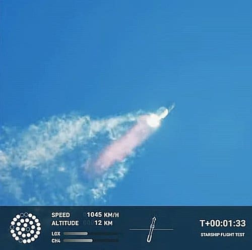
Superheavy still going strong, shortly after Max-Q
The results of the spectacular test launch last week of SpaceX’s Superheavy/Starship heavy lift rocket was predictable in almost all ways.
First, everyone knew that it was highly unlikely that the launch would do everything intended. This was the first time ever that SpaceX had fired all 33 Raptor-2 engines at the base of Superheavy, at full power. It was the first time ever that this firing took place with Starship stacked on top. It was the first time ever that the entire stack was fueled. It was the first time ever that this rocket — the world’s most powerful (twice as powerful as the Saturn-5 and about three times more powerful than SLS) — had every launched.
The number of unknowns were gigantic, which was exactly why SpaceX needed to do the launch. The company’s engineers needed to find out what they didn’t know about Superheavy in order to refine their engineering so that Superheavy will be more likely for success in its next launch. They also needed to find out what such a launch would do to their preliminary launchpad, in order to refine its engineering as well so that future launches could take place with little or no damage.
Thus, it is not surprising that there were surprises. The most significant was the actual amount of success. Superheavy functioned far better than anyone could have dreamed, retaining flight control through max-q and then flying for almost three minutes before Starship failed to separate and the entire stack lost control and had to be destroyed. Most of its engines worked, though discovering the reasons for the handful that failed will be a prime question in the subsequent investigation.
The second unsurprising thing about this launch is the reaction of the federal bureaucracy, run by Democrats and the Biden administration. It has quickly moved in to squelch any further launches at Boca Chica, likely for a considerable time. The FAA immediately initiated its own investigation while grounding all further launches from Boca Chica. The Fish & Wildlife Service has now begun detailing, almost gleefully, the amount of ground damage the launch caused, including ripping out the concrete base below the rocket and flinging chunks of debris hundreds of feet away as well as depositing a cloud of sand dust on everything up to 6.5 miles from the launchpad.
This quote however is significant, and tells us the real truth:
» Read more


