Dunes on the floor of Valles Marineris

Overview map

Dunes on the floor of Valles Marineris
Click for original image.

Cool image time! The picture to the right, cropped, reduced, and sharpened to post here, was taken on September 26, 2023 by the high resolution camera on Mars Reconnaissance Orbiter (MRO). It shows a field of scattered elongated dunes on a flat older surface with craters and what appear to be smaller ripple dunes (in the lower left). The large elongated dunes tend to be oriented in an east-west manner, while the older tiny ripple dunes appear to have a north-south orientation.

Very clearly the larger dunes appear to be traveling across that flat older surface, though whether there is any documented movement is unknown. Generally (though there are exceptions) scientists have found most of the dunes on Mars to be either inactive, or if they are moving because of the wind that movement is very tiny per year. In this case there is one dark spot on the dunes, near the center of the picture, where it appears a collapse might have occurred, suggesting recent change.

On the center right of the picture is the end point of a long ridgeline extending 10 to 12 miles to the east and rising about 7,300 feet, as shown in the overview map above. The small rectangle in the inset shows the area covered by the photograph.

At the base of that ridgeline can be seen a series of terraces descending to the west, suggesting that this hill might be volcanic in nature, with each terrace indicating a separate lava flow. The location is in the dry equatorial regions, so near-surface ice is likely not an explanation.

In the inset the mountain wall to the north is the large mountain chain that bisects this part of Valles Marineris. It overwhelms this small 7,300-foot-high ridge, rising more than 22,000 feet from these dunes with its high point still one or two thousand feet below the rim of Valles Marineris itself.

Once again, the grand scenery of Mars amazes. Imaging hiking a trail along that ridgeline, with the mountains rising far above you to the north and south.

0 comments

First Juno images of Io from December 30th fly-by

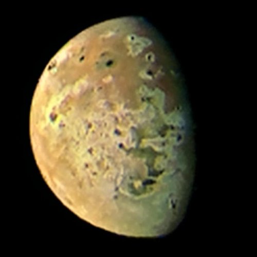
Io as seen by Juno on December 30, 2023
For original global image go here. For original of inset go here.

The first raw Juno images taken of the Jupiter moon Io during its close fly-by on December 30, 2023, the closest in more than twenty years, have been released by the science team and citizen scientists have begun processing them.

The global picture to the right, rotated and reduced to post here, was processed by Kevin Gill. The inset of the volcanic mountains near the terminator was processed by Thomas Thomopoulos. As he notes, to obtain better detail he enhanced the colors and image and then zoomed in.

In the inset, note the northeast flows coming off the two mountains near the center. With the lower mountain, this flow appears to lie on top of a larger flow that extended out almost to the mountain to the right.

Io is a planet of continuous volcanic activity. For example, when the global image above was taken, the plume of a volcano eruption was visible on the right horizon, as shown in this version, its exposure adjusted by Ted Stryk. Catching such eruptions on Io is not unusual, considering its continuous volcanic activity generated by the tidal forces the planet undergoes from its orbit around Jupiter. In fact, the very first plume was imaged in 1979 by Voyager 1 during its short fly-by, and proved a hypothesis of such activity that scientists had only published one week earlier.

2 comments

The ancientness of rocks on Mars

Ancient rocks on Mars
Click for original image.

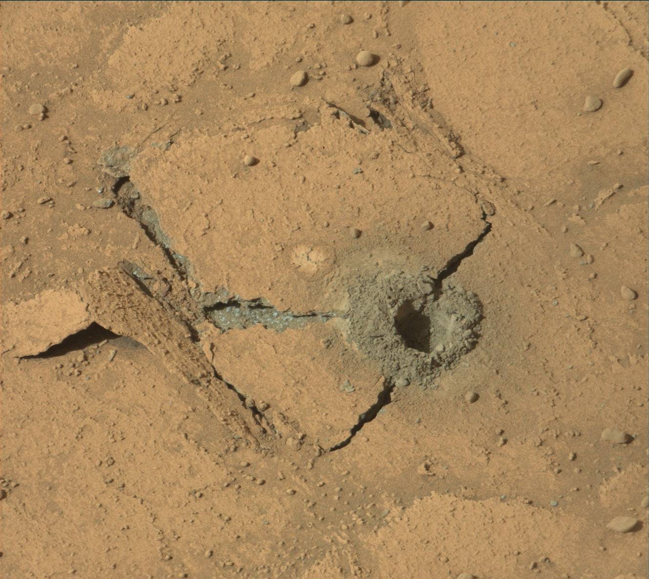
Cool image time! The picture to the right, cropped, reduced, and enhanced to post here, was taken on December 27, 2023 by the high resolution camera on the Mars rover Curiosity. It shows what is a somewhat typical rock found on the ground as Curiosity climbs Mount Sharp in Gale Crater.

Two features stand out. First, the many layers illustrate again the cyclical nature of Martian geology. Many sedimentary events occurred over a long time to create this rock, each cycle putting down a new layer, with some intervening time periods possibly removing layers as well. Such layering has now become evident in both ground photos taken by rovers as well as orbital images.

Second, the delicate nature of some layers indicates the incredibly slow erosion process on Mars, enhanced by the red planet’s one-third gravity. The atmosphere is incredibly thin, less than 0.1% of Earth’s. Yet given time the wind had been able to wear away the edges of this rock. The thin atmosphere and light gravity has also allowed some material to remain in a delicate manner that would be impossible on Earth.

Thus, for these thin flakes to have formed has required a great deal of time. The very nature of this rock speaks of an ancient terrain, shaped slowly by inanimate processes with no active life around to disturb things.

5 comments

Curiosity science team releases movies of Mars from dawn to dusk

Using its front and rear hazard avoidence cameras, the Curiosity science team had the rover take two full sets of images looking in one direction for twelve hours straight in order to create two movies of Mars that show an entire day, from dawn to dusk.

I have embedded both movies below. From the press release:

When NASAโ€™s Curiosity Mars rover isnโ€™t on the move, it works pretty well as a sundial, as seen in two black-and-white videos recorded on Nov. 8, the 4,002nd Martian day, or sol, of the mission. The rover captured its own shadow shifting across the surface of Mars using its black-and-white Hazard-Avoidance Cameras, or Hazcams.

Instructions to record the videos were part of the last set of commands beamed up to Curiosity just before the start of Mars solar conjunction, a period when the Sun is between Earth and Mars. Because plasma from the Sun can interfere with radio communications, missions hold off on sending commands to Mars spacecraft for several weeks during this time.

The first looks forward, into Gediz Vallis, where Curiosity will eventually travel. The second looks back down Mt Sharp and out across the rim of Gale Crater.
» Read more

0 comments

Mapping the major lava flood events in Mars’ volcano country

The volcanic events in Mars' volcano country
Click for original map.

In a paper just released, scientists have used the orbital data from Mars Reconnaissance Orbiter (MRO) to map on Mars forty different past volcanic eruptions of extensive flood lava covering large regions, all within the region I dub “volcano country” because its entire surface seems mostly shaped by flows of lava.

The map above, figure 1 from the paper, shows the study area (within the white rectangle), with its global context and additional information added by me on the right. Most of the largest earthquakes detected by InSight ran from north-to-south down the center of the white box. The named features are all large flood lava events, with the youngest being Athabasca. Within the Cerburus Plains feature the researchers mapped many smaller events which brought the total up to forty. From the abstract:

An area almost as large as Europe was investigated. The study revealed the products of more than 40 volcanic events, with one of the largest flows infilling Athabasca Valles with a volume of 4,000 km3. The surface appearance and material properties suggest that Elysium Planitia is composed of basalt, the most common type of lava on Earth. The area also experienced several large floods of water, and there is evidence that lava and water interacted in the past. However, while there could be ice in the ground today, it likely occurs in small patches.

None of these flood lava events involved the gigantic volcanoes that surround this region. Instead, the lava erupted from vents within this region, and then flowed downgrade to flood large areas, sometimes covering over parts of earlier lava floods. All also flowed much faster than lava on Earth, flooding vast regions — comparable to entire countries — often in mere weeks.

0 comments

Juno’s closest image of Europa suggests recent surface activity

Juno's best image of Europa
Click for original image.

Analysis by scientists of the closest image of Europa taken during Juno’s close-fly on September 29, 2022 suggests that a particular strange feature, dubbed the “platypus” due to its shape, might be very young and indicate recent surface activity that could be related to underground liquid water.

That picture, reduced and sharpened to post here, is to the right. It is figure 2 of the paper. The description of this photo from the abstract:

Intricate networks of cross-cutting ridges and lineated bands surround an intriguing 37 km (east-west) by 67 km (north-south) chaos feature with a concentric fracture system, depressed matrix margins, and low-albedo materials potentially associated with brine infiltration. The morphology and local relief of the chaos feature are consistent with formation in the collapse of ice overlying a salt-rich lens of subsurface water. Low-albedo deposits, similar to features previously associated with hypothesized cryovolcanic plume activity, flank nearby ridges. The SRU’s high-resolution view of many types of features in a single image allows us to explore their regional context and greatly improve the geologic mapping of this part of Europa’s surface. The image reveals several relatively youthful features in a potentially dynamic region, providing baselines for candidate locations that future missions can investigate for present day surface activity.

SRU is Juno’s Stellar Reference Unit camera, designed to take pictures using only the low light of Jupiter reflected onto nighttime surfaces of Jupiter’s moons. It took this photo when Juno was only 256 miles above the surface.

This feature will obviously become a prime target for Europa Clipper when it arrives into orbit around Jupiter in April 2030. From this vantage point — safer than continuous exposure to Jupiter’s magnetosphere while in orbit around Europa — the spacecraft will do 44 close-flys of the moon.

0 comments

Isolated mesa on Mars

An Isolated mesa on Mars
Click for original image.

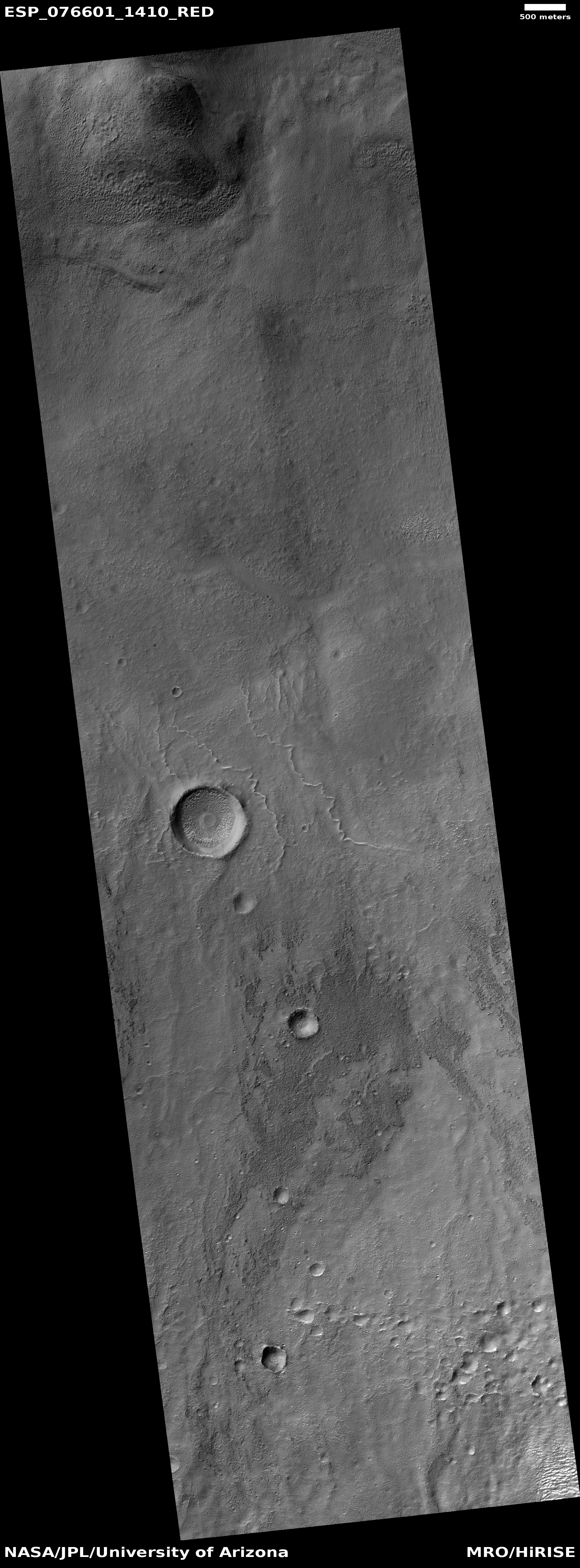
Cool image time! The picture to the right, cropped, reduced, and sharpened to post here, was taken on August 13, 2023 by the high resolution camera on Mars Reconnaissance Orbiter (MRO).

The central butte is about 100 feet high. Not only are its flanks terraced, suggesting sedimentary layers, note the many black dots on its northern slopes. Those dots appear to be many boulders that appear to have rolled down the slopes to settle mostly near the mesa’s base.

The boxwork ridges to the west and south suggest the ground was fractured in some event to produce cracks, which were later filled with material that was erosion resistent. As the terrain was worn away by wind it left these ridges behind.

The prevailing winds in this region are believed to blow mostly to the south, which might explain the parallel ridges south of the mesa. Or not. On this I am guessing entirely.
» Read more

0 comments

Update on Ingenuity

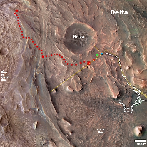
Overview mapClick for interactive map.

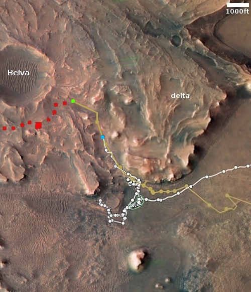
The overview map above shows the travels of both the rover Perseverance and the helicopter Ingenuity on Mars through today, with the blue dot marking Perseverance’s present location and the green dot Ingenuity’s. Because of image downloads today from Perseverance — including a few more pictures taken by the helicopter during several of its recent flights — the helicopter’s engineering team has finally been able to add the flight paths for flights #68, #69, and #70 to this map, as well as provide more accurate information about what each accomplished..

Flight #68, which took place on December 15, 2023, a few days later than originally planned, as I reported on December 20, 2023 when the first preliminary data arrived. At the time it appeared the flight had ended prematurely by almost 1,500 feet. We now know the flight did end early, but by not that much. Instead of flying, as per its flightplan, to the northeast 2,716 feet for 147 seconds and then returning to its take-off point, it flew out and back 2,304 feet for 131 seconds. The engineering team has not explained why it turned around prematurely by about 200 feet.

Flight #69 on December 20, 2023 was supposed fly 2,304 feet total over 131 seconds, also going out and back, traveling to the east-northeast. It ended up flying 2,315 feet over 135 seconds on a flight path that was almost identical to flight #68. Like most previous flights, it appears it hovered over its landing spot for a few extra seconds before descending in order to make sure it would land safely.

The final numbers for flight #70 have not yet been added to the flight log, but the engineering team has apparently been able to figure out the path the helicopter took and where it landed from the images that have been downloaded in the past few days. The flight plan had called for a relatively short flight, 849 feet long, but taking almost as long as the previous two, 129 seconds, thus allowing Ingenuity to get better and more detailed scouting pictures of the terrain below it for scientists to review.

One more detail: It appears that the Perseverance science team has decided to use Ingenuity data to guide its route. Rather than follow the planned course, as indicated by the red dotted line, the rover has been following the ground scouted by Ingenuity on its 63rd flight on October 19, 2023. This has taken Perseverance deeper into the rough fractured terrain to the south, where it likely can obtain better geological data.

It also suggests that Ingenuity’s more recent flight paths are giving us a hint as to Perseverance’s future travels.

0 comments

Japan’s SLIM lunar lander enters orbit around Moon

SLIM's landing zone
Map showing SLIM landing zone on the Moon.
Click for interactive map.

After almost four months of orbital maneuvers since its launch on September 7, 2023, Japan’s SLIM lunar lander entered lunar orbit today, with a targeted landing date of January 20, 2024.

The landing site is indicated by the map to the right near Shioli Crater. SLIM is mostly an engineering test mission, with its primary goal to test an autonomous unmanned landing system capable of putting a lander down within a small target zone of less than 300 feet across. It has some science instruments on board, but any data obtained from them will be an added bonus, since the lander is only designed to operate for about two weeks, during the first lunar day. It is not expected to survive the two-week long lunar night to follow.

Because of launch delays for both of the American landers, Intuitive Machine’s Nova-C and Astrobotic’s Peregrine, SLIM will make its attempt first.

2 comments

Curiosity takes a close-up of distant cliffs

Panorama on December 20, 2023
Panorama on December 20, 2023. Click for full image.

Close-up of a distant cliff
Click for original image.

Cool image time! The picture to the right, reduced and sharpened to post here, was taken on December 21, 2023 by the chemistry camera (ChemCam) on the rover Curiosity. Originally designed to take close-ups of rocks very nearby the rover, the science team over time discovered that they could also use this camera to get close-ups of very distant objects, providing them another way to study the geology in Gale Crater and on Mount Sharp.

The picture to the right I think shows the horizon area indicated by the arrow on the panorama above, taken the day before. Note the many many layers, a geological feature that Curiosity has discovered is ubiquitous on Mars. Over eons the entire surface of the red planet has been layered repeatedly by cyclical geological events, producing layers within layers within layers. I guarantee that when Curiosity gets closer to this cliff it will see layers inside the smallest layers ChemCam can see now.

The red dotted line on the panorama above indicates the approximate planned route that Curiosity will eventually take, cutting across in front of that mountain and turning south somewhere near but to the west of where the cliff in this picture is located.
» Read more

8 comments

A glacial lake on Mars?

A glacial lake in a
Click for original image.

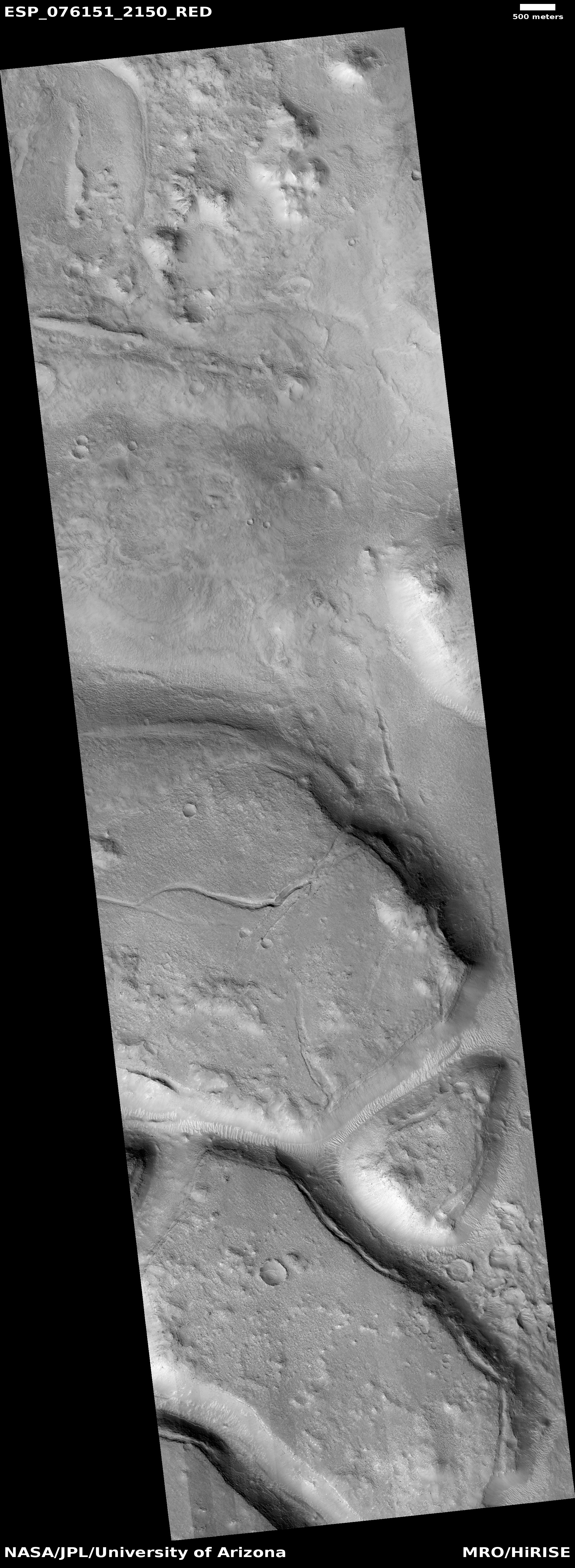
Cool image time! The picture to the right, rotated, cropped, reduced, and sharpened to post here, was taken on August 30, 2023 by the high resolution camera on Mars Reconnaissance Orbiter (MRO).

It shows what appears to be a glacial flow of ice, flowing downhill to the southwest and inside a wide canyon about three miles across. The canyon rims to the north and south are about 2,000 to 2,100 feet above the canyon’s lowest point, indicated by the string of “+” signs.

This close-up view immediately suggests a canyon whose glacier flows outward to the southwest into open lowland terrain, though the three craters, because they are undistorted, suggests that this flow is presently not active. That suggestion however would be wrong. It is always necessary to understand Martian geology to not only take close-in views at high resolution, but to zoom back and see the terrain in context.
» Read more

1 comment

ULA’s Vulcan rocket fully stacked for the first time

Peregrine landing site
The landing site for Astrobotic’s Peregrine lunar lander

In preparation for its targeted January 8, 2024 launch, ULA’s Vulcan rocket has now been fully stacked for first time in its assembly building at Cape Canaveral.

ULA’s new rocket has rolled between its vertical hangar and the launch pad at Cape Canaveral Space Force Station several times for countdown rehearsals and fueling tests. But ULA only needed the Vulcan rocket’s first stage and upper stage to complete those tests. The addition of the payload shroud Wednesday marked the first time ULA has fully stacked a Vulcan rocket, standing some 202 feet (61.6 meters) tall, still surrounded by scaffolding and work platforms inside its assembly building.

It will next be rolled to the launchpad for some final checks prior to launch on January 8, 2023. Unlike most first launches, it carries a real payload, Astrobotic’s Peregrine lunar lander, which hopes to softly place several NASA and commercial payloads near the Gruithuisen Domes in the northwest quadrant of the Moon’s visible hemisphere, as shown on the map above.

1 comment
1 48 49 50 51 52 89