The soft landslides of Mars

A soft avalanche on Mars

Context image of landslide

The light gravity of Mars, combined with different materials, a lot of dust, and a geological history different from Earth, produces events that — though reminiscent of similar geological events on Earth — are definitely not the same.

The image above, cropped and reduced to post here, was taken by the high resolution camera on Mars Reconnaissance Orbiter (MRO) and was one of the many uncaptioned images released in the November archive. If you click on the image you can see the full resolution version. It shows the tongue of a landslide inside a crater located in the planet’s southern highlands.

You can immediately see why I call it a soft landslide. The craters on its top are barely visible, as if they hit a soft surface that absorbed most of the impact. The grooves spreading southward in the slide suggest that this solid material flowed almost like mud. And the soft, smooth surface head of the slide suggests an almost liquid-like flow. As far as I can tell, this landslide had few large boulders. It was made up instead of small particles of about the same size.

To the right is an image showing the wider context of the above image, taken by Mars Odyssey and cropped and annotated by me to post here. The white box shows the entire area photographed by the full resolution image of the landslide, with the tongue of the landslide at the bottom of the box. If you look at the floor of this crater, you can see what looks like the ghost of a past smaller impact, seemingly buried in either a field of lava or soft dusty regolith. The smoothness of the crater floor also suggests a material softness, allowing it to settle into a pondlike featureless flat plain.
» Read more

0 comments

The fractured floor of Komarov Crater

Fractured floor of Komarov Crater

Cool image time! The Lunar Reconnaissance Orbiter (LRO) oblique image on the right, reduced significantly from the original to post here, shows the deeply fractured floor of Komarov Crater on the Moon’s far side. As noted at the image link,

The spectacular fractures that cut across the floor of Komarov crater [about 85 kilometers or 50 miles diameter] were formed when magma rose from the mantle, uplifting and fracturing the crater in the process. In this case the magma did not erupt to the surface, thus the fractures remain visible.

The Komarov fractures are quite large, the major left-to-right fracture that cuts across the center of the scene is over 500 meters deep [1,600 feet] and 2500 meters wide [1.5 miles]. When did they form? The large number of craters superimposed on the floor and fractures testifies to their ancient ages. Likely they are of the same vintage (>2.6 billion years) as the Mare Moscoviense lava plains just to the north

An overview of Komarov Crater as well as other LRO images of it can be found here.

The question that comes to my mind is the relative rarity of craters with such large fractures on their floors. I have noted this for Mars as well. It is expected that there is melt on the floor of all large impact craters. Why do a few produce such pronounced fractures, while most do not? This website posits one explanation, but its complexity leaves me unsatisfied. It also doesn’t explain why it happens only rarely.

1 comment

Scientists discover giant impact crater buried under Greenland ice

Scientists have discovered the existence of a giant impact crater buried under the Greenland ice.

An international team of researchers, including a NASA glaciologist, has discovered a large meteorite impact crater hiding beneath more than a half-mile of ice in northwest Greenland. The crater โ€” the first of any size found under the Greenland ice sheet โ€” is one of the 25 largest impact craters on Earth, measuring roughly 1,000 feet deep and more than 19 miles in diameter, an area slightly larger than that inside Washingtonโ€™s Capital Beltway.

They think, based on the data, that this crater is very young, one of the youngest known on Earth. At the most is is no more than 3 million years old.

8 comments

Volcanic rivers on Mars

Granicus Valles

Cool image time! The photo on the right, cropped and reduced to post here, was part of the November image release from the high resolution camera on Mars Reconnaissance Orbiter (MRO). If you click on the image you can see the full resolution picture.

The uncaptioned release webpage is dubbed “Faults in Granicus Valles.” The image itself only shows a small part of Granicus Valles, named after a river in Turkey, that flows down from the estern slopes of the giant volcano Elysium Mons. While far smaller than the four big Martian volcanoes in the Tharsis region to the east and near Marines Valles (which I highlight often), Elysium Mons still outshines anything on Earth at a height of almost 30,000 feet and a width of 150 miles. It sits at about the same northern latitude of Olympus Mons, but all by itself, rising up at the very northern edge of the transition zone between the southern highlands and the northern plains, with the vast Utopia Basin, the second deepest basin on Mars, to the west.

Overview of Elysium Mons and Granicus Valles

Granicus Valles itself is almost five hundred miles long. At its beginning it flows in a single straight fault, but once it enters the northern plains of Utopia Basin it begins to meander and break up into multiple tributaries. The MRO image above shows only a tiny portion in the northern plains, as illustrated by the white box in the overview map to the left.
» Read more

0 comments

Evidence of nitrogen ice glaciers on Pluto

Using data sent back by New Horizons during its fly-by of Pluto scientists now think they have identified land forms created by past nitrogen ice glaciers.

The washboard and fluted terrain … occur at the location on Sputnik Planitiaโ€™s perimeter where elevations and slopes leading into the surrounding uplands are lowest, and also where a major tectonic system coincides with the edge of Sputnik Planitia. The low elevation of the area makes it a natural setting for past coverage by nitrogen ice glaciers, as indicated by modeling of volatile behavior on Pluto performed by Dr. Bertrand at Ames.

Through comparison of the washboard and fluted texture with parallel chains of elongated sublimation pits (depressions in the surface formed where ice turns directly into a gas) seen in southern Sputnik Planitia, the ridges are interpreted to represent water ice debris liberated by tectonism of underlying crust. This water ice debris was buoyant in the denser, pitted glacial nitrogen ice that is interpreted to have formerly covered this area, and collected on the floors of the elongated pits. After the nitrogen ice receded via sublimation, the debris was left as the aligned ridges, mimicking the sublimation texture โ€“ washboard ridges where deposited on flat terrain, and fluted ridges where deposited on steeper slopes.

This is strange stuff. The solid bedrock here, water ice, will float on the nitrogen ice sitting on top of it. Thus, the material that wants to sublimate away, nitrogen, sometimes has to fight its way past the water ice that has risen to the top of the pile.

To put it mildly, we hardly understand these alien processes. This research is merely a first stab, the first hand-waving.

3 comments

More Pits on Mars!

Pits near Arsia Mons

Cool image time! In the November image release from the high resolution camera on Mars Reconnaissance Orbiter (MRO) were three images, dubbed by me in the collage above as number one, number two, and number three, showing pits south of Arsia Mons, the southernmost volcano in the chain of three giant volcanoes to the east of Mars’s largest volcano, Olympus Mons, and to the west of the Marineris Valles valley.

Mars overview showing pit locations

The image on the right provides the geographical context of the three pits. They are all south of the volcano on the vast lava flow plains that surround it. The location of pits #1 and #2 is especially intriguing, on the east and west edges of what appears to be a large lava flow that had burst out from the volcano, leaving a large lava field covering a vast area several hundred miles across just to the south. You can also see a similar large lava field to the north of the volcano. Both fields appear to have been formed when lava poured through the breaks created by the fault that cuts through the volcano from the northeast to the southwest.
» Read more

2 comments

The vast northern plains of Mars

The vast northern plains of Mars

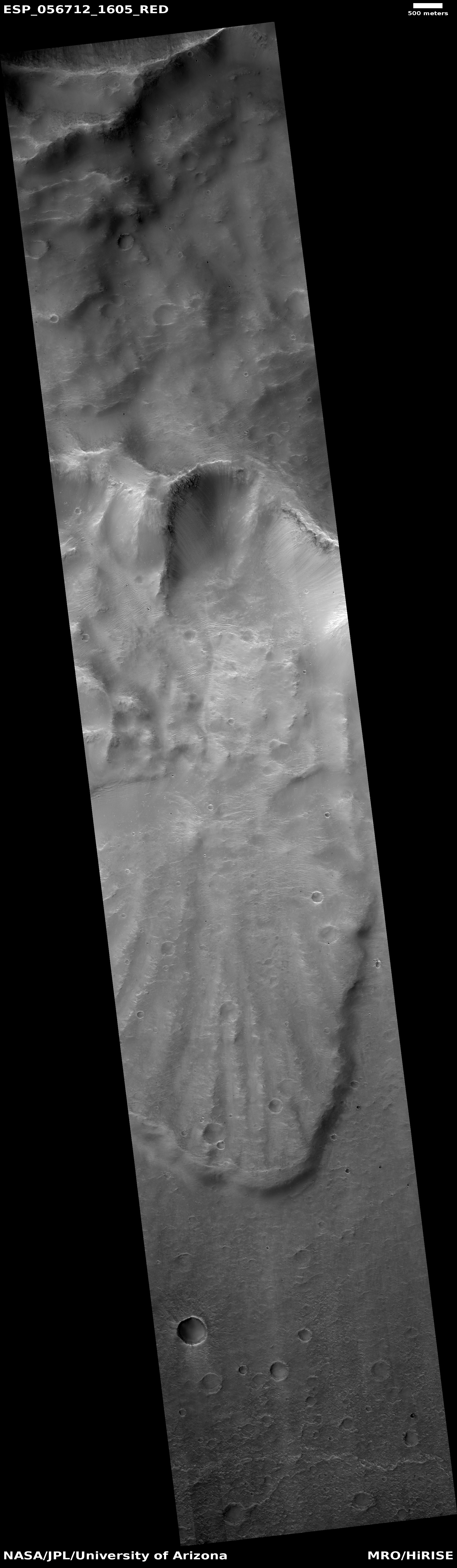
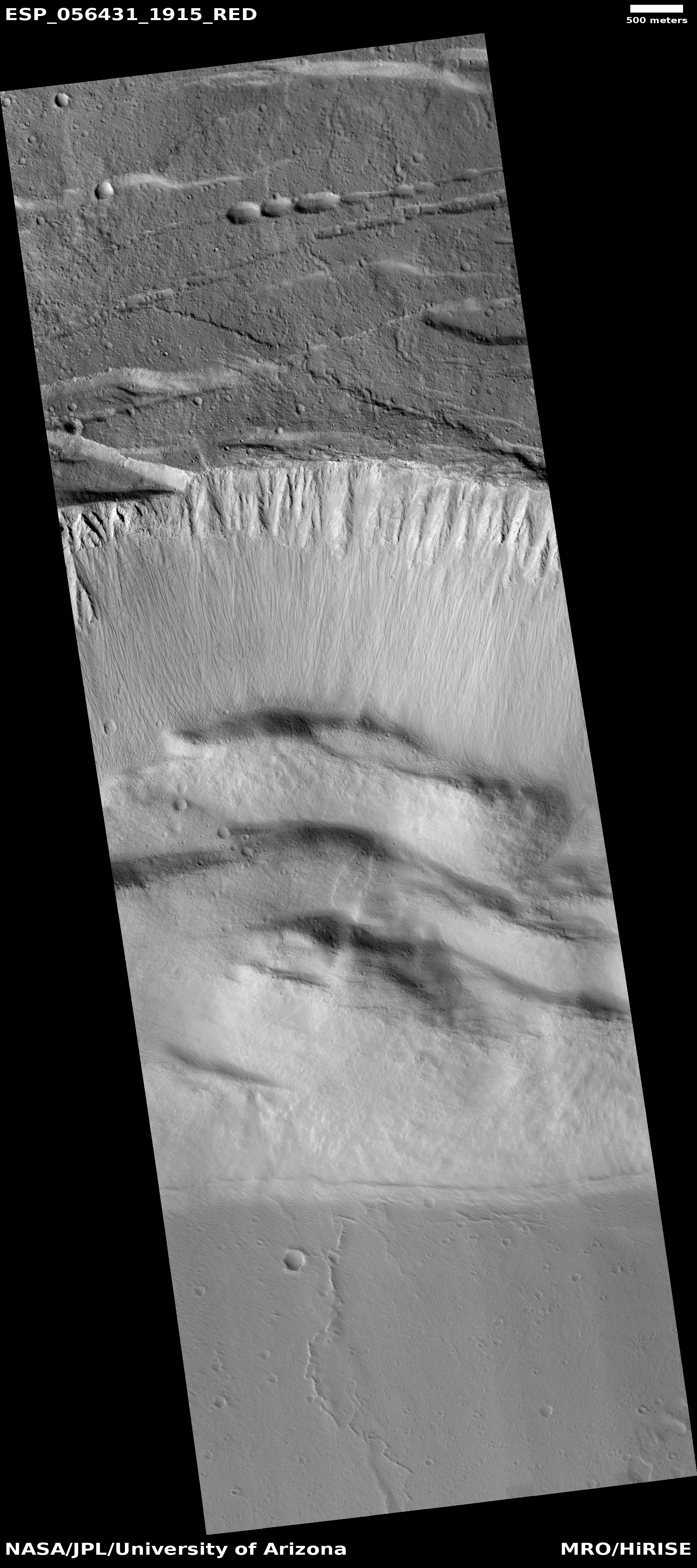
Cool image time! Actually, this image, found in the October image release from the high resolution camera of Mars Reconnaissance Orbiter (MRO), is not that interesting, in its own right. Context is all!

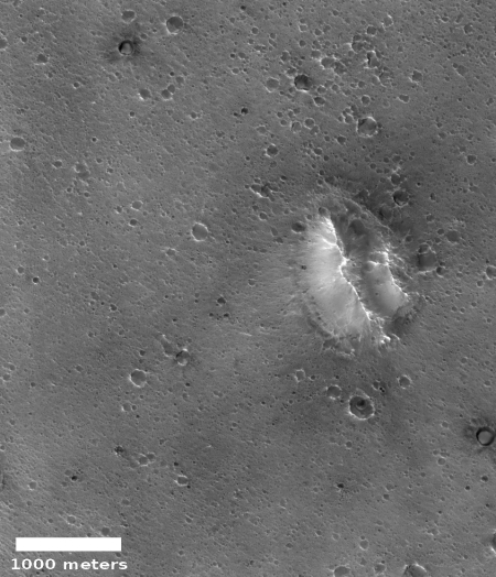
The image on the right is a small section cropped and reduced in resolution from the full image, which you can see by clicking on it. It shows one of the only interesting features in this long image strip, a small mesa sticking out all by itself in a flat featureless plain pockmarked by various small craters.

The release has no caption, though it is entitled “Northern Plains Survey.” The northern plains, while having a lot of interesting features that attract the attention of planetary scientists and thus get photographed at high resolution, is mostly featureless, at least at the resolution of the wide field survey cameras on many Mars orbiters. In order to know what is really there, they need to take high resolution images systematically, of which this image is obviously a part.

Overview image

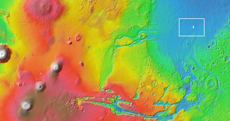
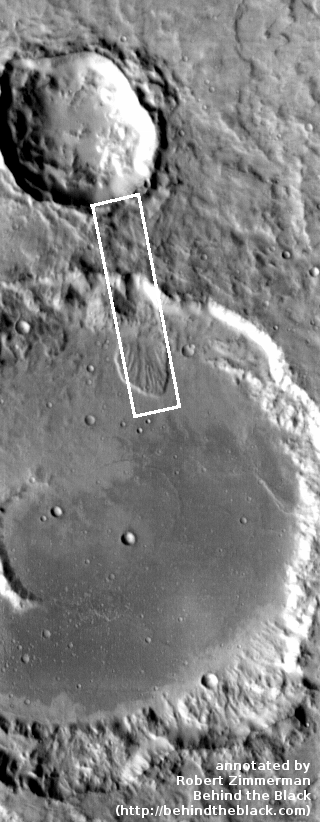
The problem is that there is so much ground to cover. This particular image was taken of a spot in the middle of the plains just to the north of the drainage outlets from Valles Marineris, as shown by the context map to the right. The tiny white spot to the right in the middle of the blue plains north of those drainage outlets is the location of this image.

Detail area of overview map

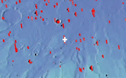
To understand how much ground needs to be covered, to the right is a close-up of the area shown by the white box in the first image above, with red rectangles indicating where MRO has already taken images. The white cross is the subject image. As you can see, most of this immense plain has not yet been imaged. It is almost as if they threw a dart to pick this one location. Most everything around it remains unseen at high resolution. Thus, to understand the geology of this one image is hampered because the surrounding terrain remains unknown, in close detail.

Mars is a big place. It is an entire planet, with the same land surface as the Earth’s continents. It still contains many mysteries and unexplored places. It will take generations to see it all.

1 comment

The steep slumping wall of a Martian volcano caldera

Caldera wall

Cool image time. The Mars Reconnaissance Orbiter science team today released a nice captioned image of the steep wall of the caldera of Ascraeus Mons, the northernmost of the three giant volcanoes that lie to the east of Olympus Mons, the biggest volcano of all. The image on the right, reduced and cropped, shows that steep wall, with full image available by clicking on it. The caption from the release focuses on the fluted upper parts of the wall.

We can see chutes carved into the soft dust that has built up on the slope, with some similarities to gully landforms elsewhere on the planet.

More revealing to me is how this image reveals the slumping that is slowing eroding the caldera’s walls while also making that caldera larger. First, the plateau above the cliff shows multiple small cliffs and pit chains, all more or less parallel to the wall. This suggests that the plateau is over time breaking apart and falling into that caldera. Think of it as an avalanche in slow motion, with the upper plateau separating into chunks as sections slowly tilt down toward eventual collapse. As these chunks separate, they cause cracks to form in that plateau, and hence the parallel cliffs and strings of pits.

On the floor of the caldera we can see evidence of past chunks that did fall, piled up in a series terraces at the base of the wall. These are covered with the soft dust that dominates Martian geology. That soft dust also apparently comprises much of the wall’s materials, and almost acts like a liquid as it periodically flows down the wall, producing the chutes at the top of the wall.

The weak Martian gravity here is an important factor that we on Earth have difficulty understanding. It allows for a much steeper terrain, that also allows structurally weaker materials to hold together that would be impossible on Earth.This image gives a taste of this alien geology, on a large scale.

2 comments

Stripes on Dione

Using data produced by Cassini while orbiting Saturn scientists have discovered long narrow stripes on the moon Dione.

Dioneโ€™s linear virgae are generally long (10 to 100s of kilometers), narrow (less than 5 kilometers) and brighter than the surrounding terrains. The stripes are parallel, appear to overlie other features and are unaffected by topography, suggesting they are among the youngest surfaces on Dione.

โ€œTheir orientation, parallel to the equator, and linearity are unlike anything else weโ€™ve seen in the Solar System,โ€ Patthoff said. โ€œIf they are caused by an exogenic source, that could be another means to bring new material to Dione. That material could have implications for the biological potential of Dioneโ€™s subsurface ocean.โ€

That they cut across the topography implies strongly that they were laid down from above, after the surface irregularities were created.

0 comments

Giant ice pinnacles on Europa

In a new paper scientists note that getting the congressionally mandated Europa Clipper safely to the surface of Jupiter’s moon might be threatened by the existence there of forests of giant five-story high ice pinnacles.

Probes have shown that Europaโ€™s ice-bound surface is riven with fractures and ridges, and new work published today in Nature Geosciences suggests any robotic lander could face a nasty surprise, in the form of vast fields of ice spikes, each standing as tall as a semitruck is long.

Such spikes are created on Earth in the frigid tropical peaks of the Andes Mountains, where they are called โ€œpentinentes,โ€ for their resemblance to devout white-clad monks. First described by Charles Darwin, pentinentes are sculpted by the sun in frozen regions that experience no melt; instead, the fixed patterns of light cause the ice to directly vaporize, amplifying minute surface variations that result in small hills and shadowed hollows. These dark hollows absorb more sunlight than the bright peaks around them, vaporizing down further in a feedback loop.

This work is based on computer models, so it has a lot of uncertainty. It also appears to assume that these pentinentes will be widespread across Europa’s equatorial regions, something so unlikely I find it embarrassing that they even imply it. I guarantee Europa’s surface will be more varied than that. If they are designing Europa Clipper properly, it will go into orbit first to scout out the best landing site, and will be able to avoid such hazards.

0 comments

Occator Crater on Ceres

Occator Crater

Cool image time! As Dawn’s long and successful mission to the asteroids Vesta and Ceres winds down, the spacecraft is taking a slew of spectacular close-up images of Ceres. The image on the right, cropped slightly to post here, is an oblique view of Occator Crater, home to the double bright spots that scientists now believe are caused by the upward seepage of a water-based brine from the interior.

The image was taken August 14, 2018 from a distance of 1149 miles. It clearly shows how the bright spots are depressions, not raised features. Additional images released this week of the floor of the crater capture a complex fracture network (seen here and here) with some fractures apparently quite deep.

All this suggests that the surface crust of Ceres is not very structurally strong, allowing a churning process that plows material up and down. The data also suggests that even on a small planetary body like Ceres the geological processes are going to be complex and often on-going, depending on material, energy, and the size of the body.

1 comment
1 126 127 128 129 130 157