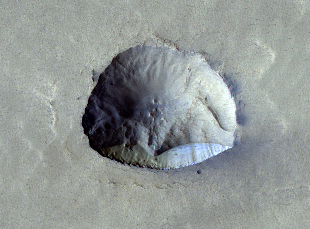
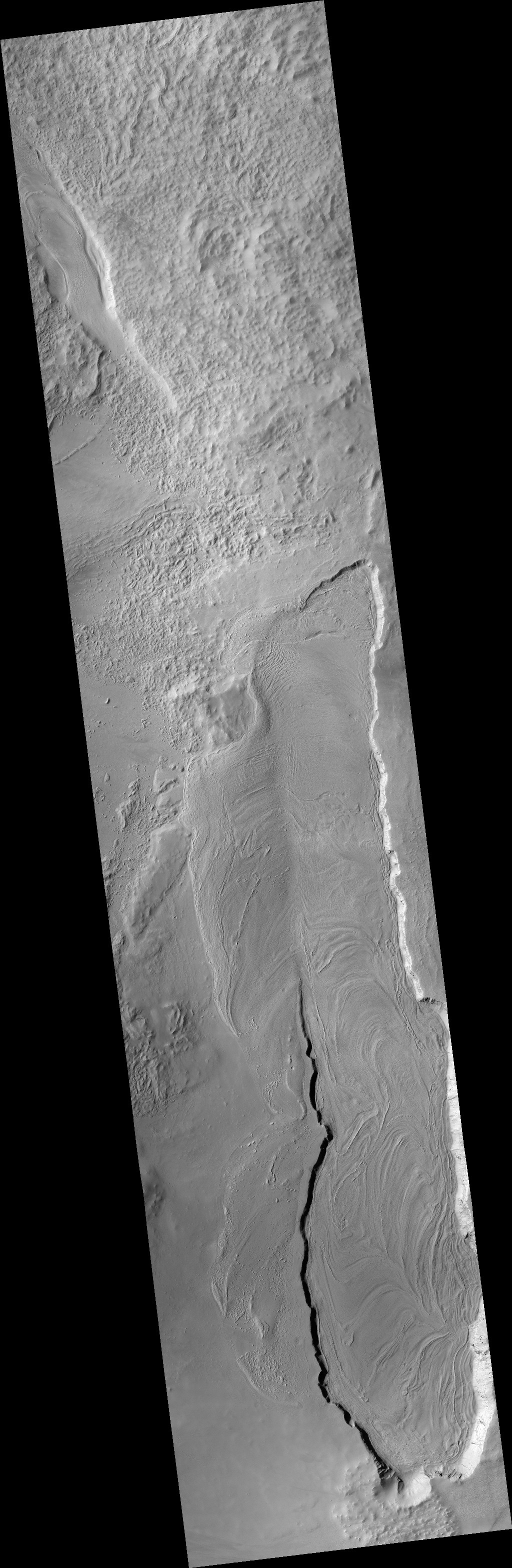
Scientists discover that mid-sized dunes near Mars’ north pole move

Mars' North Pole

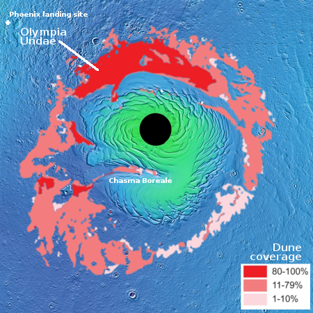
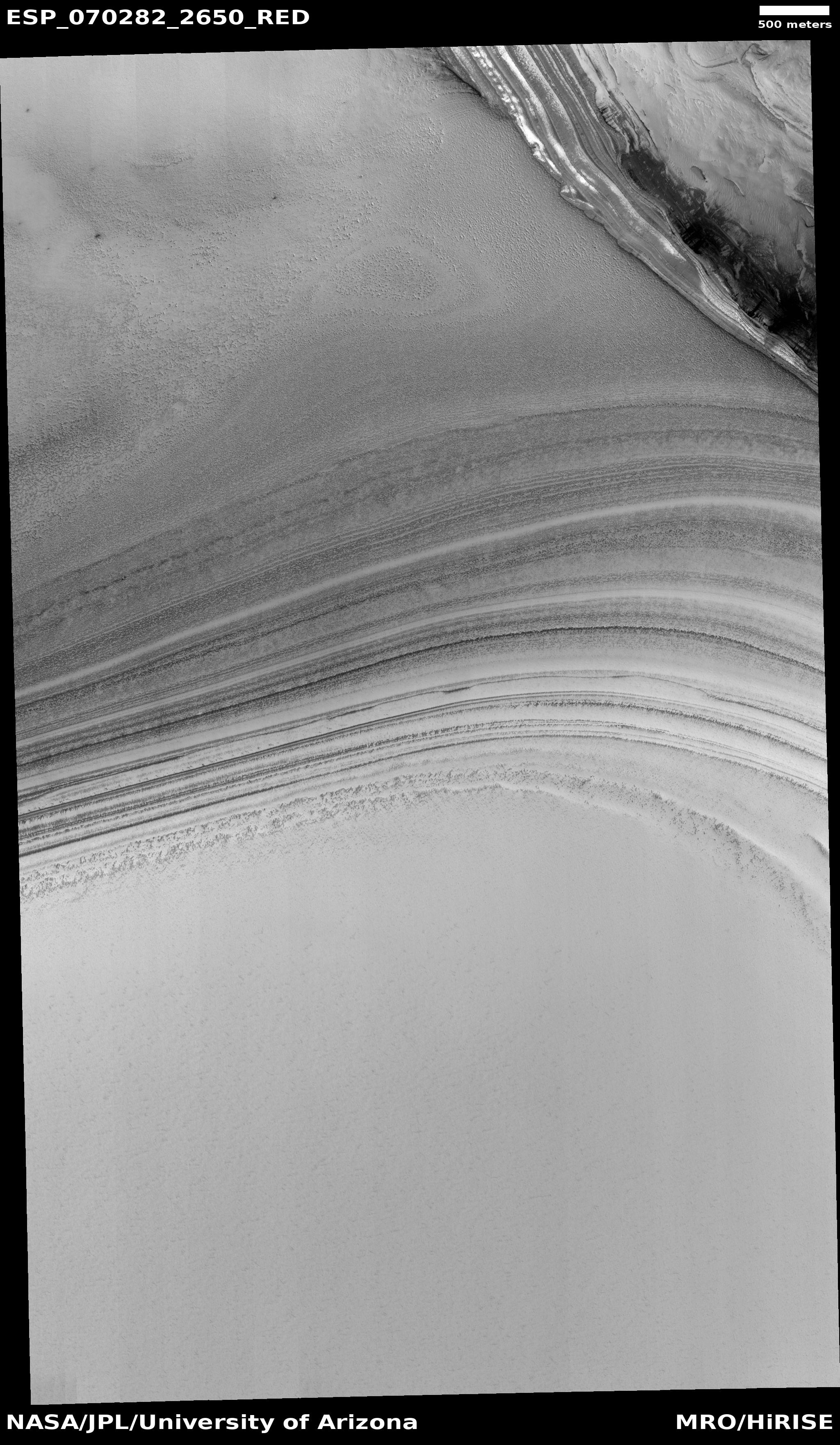
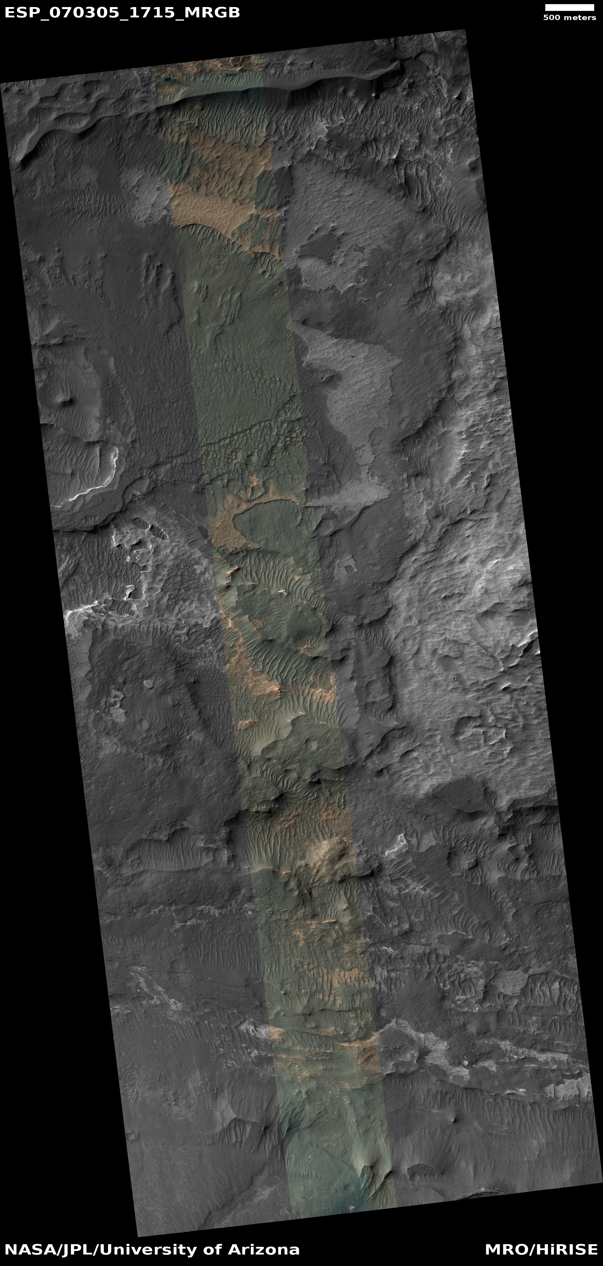
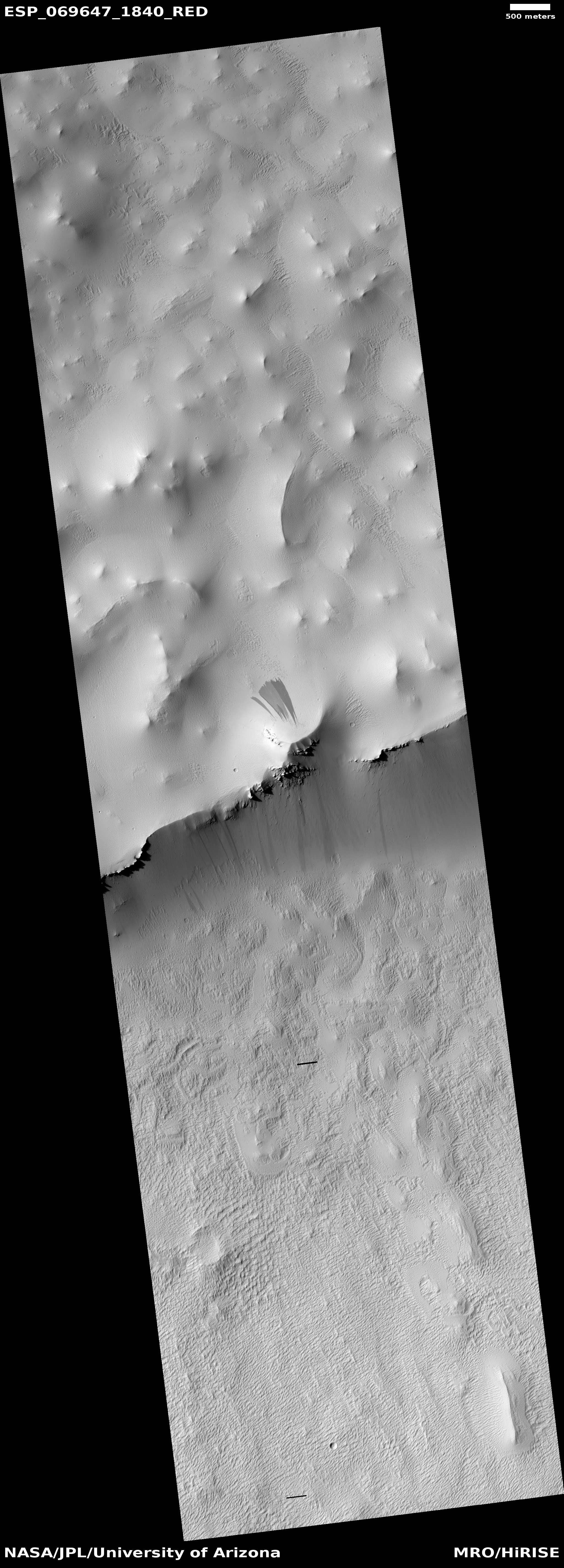
Scientists using images from Mars Reconnaissance Orbiter (MRO) collected over six Martian years (6.5 Earth years) have found that the mid-sized dunes dubbed mega-dunes near the north pole actually do move from year to year, unlike similar sized dunes elsewhere on the planet.

Megaripples on Mars are about 1 to 2 meters tall and have 5 to 40 meter spacing, where there size falls between ripples that are about 40 centimeters tall with 1 to 5 meter spacing and dunes that can reach hundreds of meters in height with spacing of 100 to 300 meters. Whereas the megaripples migration rates are slow in comparison (average of 0.13 meters per Earth year), some of the nearby ripples were found to migrate an average equivalent of 9.6 meters (32 feet) per year over just 22 days in northern summer – unprecedented rates for Mars. These high rates of sand movement help explain the megaripple activity.

Previously it was believed that such dunes were static planetwide, left over from a time when Mars’ atmosphere was thicker and could then move them more easily. This data however suggests that the winds produced over the north pole when the carbon dioxide in the atmosphere freezes in winter and sublimates back to a gas in summer are sufficient to shift these dunes in the surrounding giant Olympia Undae dune sea.

0 comments

InSight recovering from safe mode caused by Martian dust storm

Engineers have been able to regain contact with the Mars lander InSight after a Martian dust storm that put it in safe mode and cut off all communications for three days.

The mission’s team reestablished contact with InSight Jan. 10, finding that its power was holding steady and, while low, was unlikely to be draining the lander’s batteries. Drained batteries are believed to have caused the end of NASA’s Opportunity rover during an epic series of dust storms that blanketed the Red Planet in 2018.

The lander remains however in safe mode. The engineers hope they can resume limited science operations in about a week. Even before this even the limitations on InSight’s power generation due to dust on its solar panels had forced the science team to only gather data from the seismometer, and even then had to suspend all data gathering periodically.

Though the lander has survived this dust storm, it is presently unclear how much dust remains on its panels and thus how much power it can generate. If it only can generate enough power to keep the lander from freezing, but not do any science, it might be time to shut it down entirely.

0 comments

A butte on Mars

A butte on Mars
Click for full photograph.

Cool image time! Because the Martian geology inside the enclosed stone valley beyond Maria Gordon notch is so complex and exposed, the Curiosity science team is spending a lot of time there. As noted in their January 7th update:

[W]e are marvelling at the landscape in front of us, which is very diverse, both in the rover workspace and in the walls around us. It’s a feast for our stratigraphers (those who research the succession in which rocks were deposited and deduce the geologic history of the area from this). We are all looking forward to the story they will piece together when they’ve had a bit of time to think!

The image to the right, cropped and reduced to post here, was taken by the rover’s high resolution camera on December 18th, soon after it entered this stone valley and was part of scan covering both this butte as well as a nearby cliff. I had previously featured a close-up of the top of this butte and its incredible overhang on December 20, 2021. This image however shows the whole butte, which I estimate to be about 30 to 40 feet high is about 10 feet high.

Not only does the butte illustrate well the alien nature of this stark and barren Martian terrain, so does all the terrain surrounding it. The surface everywhere is nothing but pavement stones of all sizes. Once again, there is no life, something you practically never see on Earth.

6 comments

Strange land forms on the flanks of Mars’ Arsia Mons volcano

Strange landforms on the flanks of Arsia Mons
Click for original image. Click here for the context camera image.

Cool image time! The center of the photo to the right was taken by the high resolution camera on Mars Reconnaissance Orbiter (MRO) on September 5, 2021. For posting here I have rotated, cropped, and reduced it, as well as added to each side the lower resolution context camera image of this region.

The ground slopes downhill to the north. Make sure you click on the image to see the full resolution version. In only a few miles the terrain changes from a mound with small knobs to a smooth area with few knobs to a chaotic area where the larger ridges and knobs are the dominant feature, with hollows and canyons in between.

You should also take a look at the full context camera image. Just to the southeast of the above picture is a large depression that looks like it has been filled with lava, with its western rim covered by that flow. Scientists have taken a lot of high resolution pictures of this depression with MRO, trying to decipher its geology.
» Read more

4 comments

Debris in Perseverance core sample equipment

Debris in core sample carousel on Perseverance
Click for full image.

In attempting to store its sixth core sample on Mars last week, engineers discovered that Perseverance could not do so because several small pieces of the core sample had fallen into the equipment and prevented the drilling bit with the core from inserting itself completely into the sample storage carousel.

To understand the issue precisely, the engineers commanded Perseverance to first extract the bit from the carousel so they could get pictures of it.

The extraction took place yesterday (1/6) and data was downlinked early this morning. These most recent downlinked images confirm that inside the bit carousel there are a few pieces of pebble-sized debris. The team is confident that these are fragments of the cored rock that fell out of the sample tube at the time of Coring Bit Dropoff, and that they prevented the bit from seating completely in the bit carousel.

The photo to the right shows that material at the image’s bottom.

It appears this issue was anticipated when the rover was designed giving engineers a way to remove the debris. They plan to do so, but will proceed slowly as this will be the first time it will be attempted on Mars.

1 comment

A Martian cliff

A strange Martian cliff
Click for full image.

Many features on Mars immediately make one think of the Grand Canyon and the stark dramatic geology of the American southwest. Today’s cool image on the right, cropped and reduced to post here, is a typical example. Photographed on September 7, 2021 by the high resolution camera on Mars Reconnaissance Orbiter (MRO), it shows a dramatic cliff face that I estimate is about 3,000 feet high.

A closer look, however, almost always shows that this Martian terrain is not like the American southwest at all, but alien in its own way.

At the base of this abrupt cliff the terrain suddenly changes to a series of smooth downward fan-shaped flows. The cliff evokes rough boulders, avalanches, and chaotic erosion. The fans evoke a gentle and organized erosion of small particles like dust or sand. The two processes are completely different, and yet here the former is butted right up against the latter.

The fans also appear to flow out of hollows in the rough cliff, suggesting that somehow as the cliff erodes in chunks those chunks break into sand or dust, find the lowest points, and then flow downward like liquid.

How strange. How Martian. And how truly beautiful.

5 comments

Ice-filled crater on the Martian north polar ice cap

Ice-filled crater on the Martian north pole ice cap
Click for full image.

Cool image time! The photo to the right, cropped to post here, was taken on September 18, 2021 by the high resolution camera on Mars Reconnaissance Orbiter (MRO) and shows a very distinct impact crater on top of the layered deposits of ice mixed with dirt that form the bottom layers as well as surround the visible north pole ice cap on Mars.

I purposely cropped the high resolution image so that the crater is off center to show the dark streaks that appear to blow away from the crater to the northwest, west, and southwest. This asymmetric pattern suggests the wind direction at this location generally flows to the west, but the pattern might also be caused by lighting effects. The location is at 82 degrees north latitude, and the Sun was only 31 degrees high when the picture was taken, causing long shadows. Also, in the full image, you can see a whole strip of similarly oriented streaks, suggesting that these are slope streaks descending a slope going downhill to the northwest.

The overview map below also provides important information about this location.
» Read more

1 comment

Ingenuity’s next flight and the plans beyond

Overview map
Click for interactive map.

In an update posted today written by Ingenuity pilot Martin Cacan, he outlined the engineering team’s goal for the Mars’ helicopter’s next flight, its nineteenth.

This flight, which will take place no earlier than Friday, Jan. 7, takes the scout vehicle out of the South Séítah basin, across the dividing ridge, and up onto the main plateau. The precise landing target for Flight 19 is near the landing site of Flight 8. Images taken during Flight 9 by the rotorcraft’s high-resolution Return-To-Earth (RTE) camera were used to select a safe landing zone.

…Spanning 207 feet (63 meters), this flight will last about 100 seconds at a groundspeed of 2.2 mph (1 meter per second) and altitude of 33 feet (10 meters) while taking 9 new RTE images. The final act of the flight is to turn nearly 180 degrees to flip the RTE camera to a forward-facing orientation for future flights toward the river delta. [emphasis mine]

The green line in the map to the right indicates the exact path, going about 207 feet to the northeast. The red dot marks the location of Perseverance on December 8, 2021, the last time the Perseverance science team updated their map showing the rover’s travels.

The highlighted words are the most important. Cacan also said this in his update:

The current mission goal is to reach the Jezero river delta to aid the Perseverance rover in path planning and scientific discovery.

Assuming the helicopter continues to function correctly, their next flights will apparently be aimed towards the delta. Whether that path will follow the planned route marked by the dashed yellow line, or cut straight across, is not clear. If the latter, that implies they have revised Perseverance’s planned route so that it also cuts straight across from about the point of Ingenuity’s next landing site.

More likely Cacan was not speaking literally, and that the route Ingenuity will take to the delta will follow the planned route, around that crater to the northeast.

0 comments

Ice canyons at the Martian north pole

Ice canyons at the Martian north pole
Click for full image.

Cool image time! The photo to the right, cropped and reduced to post here, was taken on July 24, 2021 by the high resolution camera of Mars Reconnaissance Orbiter (MRO) and shows one small portion of the edge of Mars’ north pole ice cap.

The many layers in that ice cap are clearly evident, with some darker because they were probably laid down at a time when the Martian atmosphere was more filled with volcanic ash. According to the presently accepted theory, the layers show the cyclical climate patterns of Mars, caused by the large shifts in its obliquity, or the tilt of the planet along its rotational axis, ranging from 11 to 60 degrees. Presently Mars is tilted 25 degrees, similar to Earth’s 23 degrees. The two extremes cause the planet’s water ice to shift back and forth from the mid-latitudes to the poles, causing the layers.

The height of this layered cliff face is probably about 1,500 feet, though that is a very rough estimate. Notice also that this image shows an ice canyon running from the left to the right and flowing into a much larger ice canyon to the right. The top cliff is probably about a third the height of the bottom cliff.

The overview map below shows gives the context, not only in place but also in time.
» Read more

1 comment

The badlands on the floor of Valles Marineris

The badlands on the floor of Valles Marineris
Click for full image.

Cool image time! The recent discovery that there might be a near surface reservoir of ice on the floor the canyon Valles Marineris, near the Martian equator, immediately brought this location to the forefront as a possible site for establishing colonies. The weather will be less harsh than higher latitudes, the low elevation means a thicker atmosphere, and the terrain will be more appealing than the boring flat northern lowlands.

The picture to the right, cropped and reduced to post here, illustrates however the likely difficulties of landing and living on the floor of Valles Marineris. Taken on July 26, 2021 by the high resolution camera on Mars Reconnaissance Orbiter (MRO), the photo shows just one small area of the floor of Ius Chasm, the western part of Valles Marineris and about 300 miles to the east of that water reserve.

In this one picture we can see trapped sand dunes in hollows, eroded depressions, mottled terrain resembling stucco, and innumerable cliffs and sinks and plateaus. For the first manned spacecraft to land on Mars, this is not a good first choice. Even later, when the first bases have been built, this terrain would still be forbidding for the early colonists to land in and traverse.

The overview map below shows exactly where this picture is relative to the rest of the Valles Marineris.
» Read more

16 comments

Slope streaks in frozen lava flows on Mars

Slope streaks on frozen lava
Click for full image.

Cool image time! The photo to the right, cropped and reduced to post here, was taken on June 5, 2021 by the high resolution camera on Mars Reconnaissance Orbiter (MRO). It shows a ridgeline at the base of the giant volcano Pavonis Mons, with slope streaks on ridge’s north and south sides.

Slope streaks are a mysterious phenomenon unique to Mars. While they resemble an avalanche, they do not change the topography of the surface at all. They appear to occur randomly year round, fading slowly with time. Also, while most are dark, scientists have also spotted bright slope streaks as well.

Slope streaks also only appear on surfaces covered with a layer of fine dust, something that is obviously the case in the cool image to the right. There is so much dust on the surface here that bedrock only appears at the top of the ridge, peeking out in only a few places.

The location of this image, as shown in the overview map below, adds some additional details.
» Read more

1 comment

The barren rocky terrain in the mountains of Gale Crater

Curiosity's view looking south towards Mt Sharp, Sol 3333, December 21, 2021
Click for full resolution image. Original photos can be found here, here, here, here, and here.

Overview map
Click for interactive map.

Cool image time! Curiosity yesterday used its navigation cameras to take a panorama of the view inside Maria Gordon Notch. The mosaic above, created from five images taken by the right navigation camera, shows the view looking south and uphill towards Mount Sharp. The heights of the nearest four hills are likely ranging from 30 to 100 feet.

The red dotted line indicates the planned route out of Gordon Notch and up onto the Greenheugh Pediment. If you click on the panorama to look at the full resolution version, you will see that the exit route looks extemely rough, possibly too rough for Curiosity to handle. How the science team handles this issue will be fascinating to watch in the coming weeks.

The map to the right gives us an overview. The white line is Curiosity’s actual travels. The red dotted line marks the planned route. The yellow lines indicate the area covered by the panorama above.

The most striking feature of this Martian terrain is its stark barrenness. All one can see in all directions are rocks and inanimate geology. There is no life, none at all. On Earth it is practically impossible to find any mountainous spot as barren as this, even in the most extreme and hostile environments.

As I’ve said before, Mars is strange, Mars is wonderful, and above all, Mars is alien.

0 comments

Curiosity: Through the notch and looking back

Looking back at the entrance to Gordon Notch
Click for full image.

The Mars rover Curiosity has now climbed up into Maria Gordon Notch. The image to the right, reduced to post here, was taken by the rover’s left navigation camera and looks back at the entrance to the notch, with the floor and rim of Gale Crater beyond. The crater floor is about 1,700 feet below and the rim is about 30 miles away.

The red dotted line indicates the path Curiosity took after entering the notch, traveling about 80 feet to the southeast. The rover will continue south inside the notch for another 800 feet or so and then turn west, climbing out of the notch and up onto the Greenheugh Pediment and continuing west until it gets to the base of Gediz Vallis Ridge, a ridge that had been in prominent view about a year ago when the rover was north of it but lower down the mountain. (See the panorama in this February 2021 post.)

Below is another picture from a day earlier, this time taken by the rover’s high resolution mast camera. I think it looks up at the top of the western cliff, but now looks at that cliff after having gone past it slightly.
» Read more

4 comments

Ingenuity successfully completes its 18th flight

According to a JPL Twitter post today, on December 15th Ingenuity successfully completed its 18th flight, flying 754 feet for just over two minutes.

The plan had been to continue north to cross the rough Seitah region as the helicopter heads back to the spot where Perseverance initially dropped it. Though at this moment no specific information about the flight’s direction or landing place have been revealed, its success suggests it went exactly as planned.

1 comment

Perseverance scientists: First volcanics then water in Jezero Crater

On December 15th the Perseverance science team presented a summary of the rover’s first nine months exploring the floor of Jezero Crater, finding evidence first of volcanic lava activity followed by several periods where water covered the these same rocks.

“These rocks that we originally thought might be sedimentary rocks, these are in fact igneous [volcanic] rocks,” said Kelsey Moore at the California Institute of Technology (Caltech). “And even more excitingly, they’re not just igneous rocks – there’s more history to the story.”

The analysis of the rocks’ compositions revealed minerals that are generally produced by interactions between water and rock, as well as traces of two different salts that were probably left behind as salty water flowed through the cracks and pores in the volcanic rock.

The variety of minerals indicates that these rocks were probably underwater at least twice. “Two different types of liquid with two different types of chemistries points towards two different episodes of liquid water interaction,” said Eva Scheller, also at Caltech.

It seems strange that the scientists were surprised that Jezero Crater has a history of volcanic activity. Most craters when formed have what is called impact melt in their crater interior. The impact not only carves out the crater, the heat of impact melts the rock. Possibly the scientists expected such impact melt to be well buried and not accessible to Perseverance.

Regardless, this data will be used as the baseline for documenting the geological history of this region on Mars as Perseverance continues its journey across the floor of the crater, up onto the delta, and then out of the crater into the uplands beyond.

0 comments

Cracking glaciers on Mars

Cracking glaciers on Mars
Click for full image.

Cool image time! The photo to the right, cropped and reduced to post here, was released today as the picture of the day for the high resolution camera on Mars Reconnaissance Orbiter (MRO). Located in the 2,000 long northern mid-latitude strip that I dub Mars’ glacier country, it shows many of the numerous glacial features that are routinely found in images taken in this region. According to Dan Berman, senior scientist at the Planetary Science Institute in Arizona, who wrote the caption,

This observation shows a lobe-shaped debris apron emanating from a massif (shown in the upper left of the image) in the Protonilus Mensae region in the Northern Hemisphere of Mars. These aprons are composed of nearly pure water ice with a layer of debris on the surface protecting the ice from sublimation (going directly from a solid to gaseous state). This image shows different terrain types on the apron that indicate the presence and flow of ice, from smoother polygonal terrain closer to the massif, to rougher, patterned ground commonly called “brain terrain.” Also visible on the apron are a series of linear pits.

Protonilus Mensae is the central mensae region in that mid-latitude strip of glaciers.The overview map below shows the location of this photo in that region. Also below is a close-up of the linear pits and cracked terrain surrounding that oblong mound, as indicated by the white rectangle.
» Read more

0 comments

Scientists discover underground reservoir of hydrogen, likely ice, near Martian equator

Detection of underground hydrogen in Valles Marineris
Click for full image.

In what could be a very significant discovery, scientists using Europe’s Trace Gas Orbiter (TGO) have discovered a surprisingly large underground reservoir of hydrogen, likely ice, near Martian equator and inside the solar system’s largest known canyon, Valles Marineris.

The map to the right, reduced to post here, provides all the important data. From its caption:

The coloured scale at the bottom of the frame shows the amount of ‘water-equivalent hydrogen’ (WEH) by weight (wt%). As reflected on these scales, the purple contours in the centre of this figure show the most water-rich region. In the area marked with a ‘C’, up to 40% of the near-surface material appears to be composed of water (by weight). The area marked ‘C’ is about the size of the Netherlands and overlaps with the deep valleys of Candor Chaos, part of the canyon system considered promising in our hunt for water on Mars.

What the caption does not note is the latitude of this hydrogen, about 3 to 10 degrees south latitude. Assuming the hydrogen represents underground ice, this would be the first detection on Mars below 30 degrees latitude, and the very first in the equatorial regions. Data from orbit has suggested that Mars has a lot of water ice, found near the surface more and more as you move into higher latitudes above 30 degrees and making Mars much like Antarctica. Almost no ice however had until now been detected below 30 degrees latitude. As the European Space Agency’s press release noted,
» Read more

6 comments

Visible clean water ice on Mars

Crater with ice scarp
Click for full image.

Cool image time! The photo to the right, cropped and reduced to post here, is today’s picture of the day for the high resolution camera on Mars Reconnaissance Orbiter (MRO). Taken on September 13, 2021, it shows an exposed scarp on the southern inner wall of a small 800-foot-wide crater.

What makes that scarp intriguing is its blue color. As noted by Shane Byrne of the Lunar and Planetary Lab University of Arizona, who wrote the caption:

This north-facing cliff appears to expose icy material that’s similar to other pole-facing scarps showing buried ice elsewhere on the planet. These cliffs give us a cut-away view of the buried ice in that location and can help answer questions about what the Martian climate was like when this ice formed.

The crater itself sits inside a much larger crater, as shown in the wider picture below.
» Read more

7 comments

Curiosity looks back at its entire journey

Curiosity looking back across Gale Crater
Click for high resolution mosaic. Original images here, here, here, and here.

Wide overview map
Click for interactive map.

Cool image time! The mosaic above was created from four photos taken by Curiosity’s left navigation camera on December 12, 2021, just after the rover had moved into Maria Gordon Notch. The view is to the north, looking back at the rover’s journey climbing up the floor of Gale Crater into the foothills of Mount Sharp. The rim of Gale Crater can be seen about 25 to 30 miles away.

The cliff in shadow on the left is about 40 feet high. The cliff in sunlight on the right is between 30 to 60 feet high, depending on where you measure.

The overview map to the right shows Curiosity’s entire journey, with the yellow lines indicating the approximate area covered by the mosaic above. All told the rover has climbed about 1,700 feet since it landed. While much of the rover’s route is blocked from our view by the cliffs on left, the nearest sand dune sea in the center of the mosaic is the one that the rover circled around from January 2021 to June 2021.
» Read more

1 comment

Curiosity takes a close look at a Martian cliff

A cliff of Mars
Click for full resolution. Original images here and here.

Curiosity has now moved up and into Maria Gordon Notch, a gap in the mountains of Gale Crater that is about forty feet wide, with a 40-foot-high cliff on its western side and a 30 to 60 foot cliff on its eastern side.

The mosaic above, created from two navigation camera images, looks up at the top half of that western cliff. Note the many many layers, each one of which records some climate or volcanic event in Mars’ geological history. The Mars we see today took a long time and many events to become what it is. Such layers however have not been seen everywhere by Curiosity. Compare for example this layered cliff with the massive outcrop dubbed Siccar Point and looked at closely by the rover in October. In that outcrop the layers were either non-existent, or merged together during some subsequent geological process.

Note also the pond of sand/dust at the center-bottom, nestled in a hollow but sitting almost vertical. That the dust can maintain itself at such an angle illustrates Mars’ lighter gravity, about 39% of Earth’s, which in turn allows for a much steeper angle of repose. That lighter gravity also allows for some sections of rock to stick out more precariously than possible on Earth.

As Curiosity moves through the notch in the next few days, more such cool pictures will become available, and I shall post them.

5 comments
1 49 50 51 52 53 128