
Ingenuity next flight will begin route retracing its path
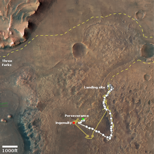
The Ingenuity engineering team has revealed that the helicopter’s 15th flight on Mars will have it begin retracing its steps, following approximately the same flight route as it heads back towards Perseverance’s landing site in Jezero Crater.
Flight #15 is the start of our journey back to Wright Brothers Field [the helicopter’s initial flight test area just north of the landing site]. Taking place no earlier than Saturday, Nov. 6 at 9:22 a.m. PT, or 12:03 LMST (local Mars time), the 254th sol (Martian day) of the Perseverance mission, Flight #15 will return Ingenuity back to the Raised Ridges region, imaged in Flight #10. In this flight the helicopter will traverse 1,332 feet (406 meters) during 130 seconds of flight, travelling at 11.1 mph (5 mps) groundspeed. We’ll capture color return-to-earth (RTE) high resolution (13MP) images, one post-takeoff pointed to the SW, and nine pointed toward the NW along the flight-path. Nominal altitude for the flight is expected to be 39.3 feet (12 meters) above ground level.
This will be the second flight of Ingenuity during Mars’ summer low air-density, requiring that the rotor blades are spun at 2,700 RPM to compensate. This flight will generate critical high-RPM motor performance, which the team will use to design and tailor upcoming low-density flights in the months ahead.
Perseverance is presently sitting in an area they have dubbed Seitah, a region the rover skirted around to get to this point. I had hoped both the helicopter and rover would return to the north cutting across Seitah and thus scout out new terrain. Instead, it appears that both the rover and helicopter will return as initially planned, traveling over the same ground both took to get where they are today.
In other words, the teams have decided to take the safest route, though it will provide them much less new science data. While this might seem prudent, it really appears overly cautious, based on the capabilities of Perseverance and the roughness of the terrain in Seitah. Curiosity is presently traveling across far more difficult terrain in the mountains at the foot of Mt Sharp, and it is doing so with wheels that are damaged and not as well designed as Perseverance’s. Not roving in uncharted terrain seems a waste of Perseverance’s capabilities.


