Expanded craters in Martian ice

Expanded craters in Martian ice
Click for full image.

Cool image time! The photo to the right, rotated, cropped, reduced, and sharpened to post here, was taken on August 18, 2022 by the high resolution camera on Mars Reconnaissance Orbiter (MRO). It includes a wide variety of geology related to sublimating ice, including expansion cracks as well as several different examples of what scientists call “expanded craters,” impacts that occurred in near surface ice and have been reshaped by the ice’s melting and sublimation at impact and then later. It also shows some obvious glacial fill in the two distorted craters at the center right.

A 2017 dissertation [pdf] by Donna Viola of the University of Arizona outlines nicely what we know of Martian expanded craters. As she notes in her conclusion:
» Read more

Scientists: Viking-1 might have landed on a field of Martian tsunami debris

The geological history of the Viking-1 Mars landing site

As outlined in their new paper [pdf], a team of scientists now hypothesize that the features that surrounded Viking-1 when it landed on Mars in 1976 were caused by two past Martian tsunamis. Each tsunamis occurred due to an impact in the theorized ocean that is believed to have existed in this part of Mars’ northern lowland plains several billion years ago.

The graphic to the right, figure 8 from the paper, shows the hypothesized sequence of events. From the caption:

(a) Pohl crater forms within a shallow marine environment, (b) triggering tsunami water and debris flow fronts. (c) The wave fronts extensively inundate the highland lowland boundary plains, including a section ~ 900 km southwest of the impact site. (d) The ocean regresses to ~ − 4100 m, accompanied by regional glacier dissection, which erode the rims of Pohl and other craters. (e) The younger tsunami overflows Pohl and parts of the older tsunami. Glaciation continues, and mud volcanoes later source and emerge from the younger tsunami deposit. (f) ~ 3.4 billion years later, the Viking 1 Lander touches down on the edge of the older tsunami deposit.

The overview map below provides the larger context.
» Read more

A Martian knife mesa with terraces

A Martian knife mesa with terraces
Click for full image.

Cool image time! The photo to the right, rotated, cropped, reduced, and sharpened to post here, was taken on August 21, 2022 by the high resolution camera on Mars Reconnaissance Orbiter (MRO). It shows what the scientists label as a “layered mound.” It also shows a plethora of geological mysteries, all of which relate to the as yet not quite understood geological history of Mars.

First, note the different colors north and south of the ridgeline. According to the science team’s understanding of what these colors mean [pdf], the orange-red to the north suggests dust, while the bluish-green to the south suggests coarser materials, such as rocks and sand. Though frost and ice are generally bluer, such things are generally found on the pole-facing slopes where there is less sunlight. Thus the bluish-green material to the south is unlikely to be ice or frost, though this is not impossible, as the picture was taken in the winter and the latitude is 35 degrees north.

Why however is there such a dichotomy of rocks, sand, and dust between the north and south slopes? And if frost and ice, why is it more prominent to the south, when it should instead be more prominent to the north?

Other mysteries: Is the circular depression on the ridgetop an impact crater or a caldera? If the latter, this suggests the mound is some kind of volcano, likely mud, though lava is not excluded. If so, however, why is there no caldera on top of the ridge to the south?

The location, as shown in the overview map below, reveals other puzzles.
» Read more

Monitoring the tiger stripes on Martian dunes

Dunes with tiger stripes
Click for full image.

Today’s cool image takes us back to a previous cool image, from December 2020. The photo to the right, rotated, cropped, reduced, and enhanced to post here, was taken on August 22, 2022 as part of a regular monitoring program of these worm-shaped and tiger-striped dunes in 42-mile-wide Kunowsky Crater, located in the northern lowland plains of Mars at the high mid-latitude of 57 degrees north.

The tiger stripes appear to be the northern hemisphere’s version of what are called “spiders” in the south, where each spring the mantle of dry ice that settles on the surface in winter begins to sublimate away, from the bottom up. The trapped gas eventually escapes at the mantle’s weak points where it cracks.

When the gas escapes it spews dust onto the surface, creating the dark patches. In the southern hemisphere, the ground is generally stable, and the gas travels and escapes along the same routes each year, creating relatively permanent spider-like tributary patterns. In the north the ground is less stable, so the dark streaks form more randomly from year to year.

This monitoring campaign, first begun in 2008, is looking to see how these seasonal changes might change these northern dunes. The white rectangle in the image shows an area shown in close-up below, comparing 2020 with 2022 to see what changes might have occurred.
» Read more

Frozen glacial eddies on Mars?

Overview map

Frozen glacial eddies on Mars?
Click for full image.

Cool image time! The photo to the right, cropped, reduced, and enhanced to post here, was taken on August 26, 2022 by the high resolution camera on Mars Reconnaissance Orbiter (MRO). Though the science team labels this image vaguely as showing “Features in Mamers Valles,” the features are likely glacial ice since this location is at the western end of the 2,000-mile-long northern mid-latitude strip I dub glacier country, where glacial features are seen everywhere.

The white dot marks this picture’s location in Mamers Valles, as shown on the overview map above. This particular Martian channel, that meanders in a wildly random manner (including a few sharp ninety degree turns), is theorized [pdf] by some scientists to have formed not by surface flows but by a subterranean drainage that created voids. On the surface the voids caused sagging, collapses, and the eventual formation of the surface channel.

Under such conditions, any ice in the channel would not necessarily have a clear flow direction, thus providing an explanation (though hardly certain) of the eddy-like shape of these features.

Colliding glaciers

Overview map

Colliding glaciers

For today’s cool image we return once again to glacier country in the northern mid-latitudes of Mars. The picture to the right, rotated, cropped, reduced, and enhanced to post here, was taken on August 28, 2022 by the high resolution camera on Mars Reconnaissance Orbiter (MRO). It shows a spot where I think glacial flows coming from the north and south have collided at a low point. The white dot in the box on the overview map above marks its location, with the inset showing the mesas to the north and south that suggest this flow pattern.

What makes these colliding flows especially cool is the source of the northern flow. It appears that came out of the impact heat from that crater, which caused the ice on the downhill side to flow. You can also see the same phenomenon a short distance to the east, with a much smaller crater, likely a secondary impact from the first.

Note also the glacial fill inside the larger crater. This impact happened on top of older glaciers, but later climate cycles caused more ice to be deposited within the crater afterward. That this glacial fill appears terraced and thus layered also suggests that there were several if not many such later climate cycles.

Glaciers everywhere in Mars’ glacier country

Glaciers everywhere in Mars' glacier country
Click for full image.

Cool image time! The picture to the right, rotated, cropped, reduced, and annotated to post here, was taken on August 24, 2022 by the high resolution camera on Mars Reconnaissance Orbiter (MRO). It shows glaciers apparently flowing down from two different mesas to the north and south.

The arrows indicate a major glacial stream coming from two directions. The many layered flow on the image’s upper right illustrates the many past climate cycles of Mars, with each subsequent period of snowfall and glacial growth producing progressively less ice. The chaotic region in the lower right marks what I think is the lowest point between the two mesas. Here the flows form eddies as the glaciers collide.

The overview map below shows us why there are so many glaciers at this spot on Mars.
» Read more

The Martian cycles of climate change, as shown in just one crater

The Martian cycles of climate change, as shown in one crater

Cool image time! The photo to the right, rotated, cropped, reduced, and enhanced to post here, was taken on September 2, 2022 by the high resolution camera on Mars Reconnaissance Orbiter (MRO). The science team titled this picture “Gullies with Terminal Ridges on Glacial Crater Fill,” a title that in one phrase encapsulates everything we see here of this unnamed 8-mile-wide crater’s western rim and interior.

The crater is located at 46 degrees south latitude inside the much larger 145-mile-wide Kepler Crater, and about 1,500 miles east of Hellas Basin in a region where a lot of glacial ice is found. A context camera image taken in July 2020 shows the entire crater floor apparently covered with glacial fill that on the edges appears to be eroding away.

Today’s high resolution photo focused on the western part of the crater, where that eroding edge was instead replaced by a meandering ridge reminiscent of a moraine. The gullies on the interior slope to the west, as well as the parallel north-south cracks, suggest that debris falling and sliding down from that rim had pushed up against this glacial ice and created that ridge.

There is a lot more to this geology however.
» Read more

A cliff face of volcanic erosion on Mars

A cliff face of volcanic erosion on Mars
Click for full image.

Today’s cool image is a variation of yesterday’s, showing another area on the edge of Mars’ largest volcanic ash field, dubbed the Medusae Fossae Formation and about the size of India. This time however the edge is an abrupt cliff, not the slow petering out of wind-shaped mesas.

The picture to the right, cropped, reduced, and sharpened to post here, was taken on August 27, 2022 by the high resolution camera on Mars Reconnaissance Orbiter (MRO). It shows what I very roughly estimate to be a 1,500 to 2,500 foot high cliff that appears to delineate the edge. To the north we have a plateau of intersperse layers of flood lava and ash. To the south those layers have eroded away, leaving a rough lava plain with a handful of scattered wind-sculpted mesas.

The overview map below, by providing a wider view of his region, makes its nature clearer.
» Read more

Erosion at the edge of Mars’ biggest volcanic ash field

Erosion at the edge of Mars' biggest ash field
Click for full image.

Cool image time! The photo to the right, rotated, cropped, reduced, and sharpened to post here, was taken on August 13, 2022 by the high resolution camera on Mars Reconnaissance Orbiter (MRO). It is another fine example of the wind-blown sculpted terrain that one finds routinely in Mars’ largest volcanic ash field, dubbed the Medusae Fossae Formation. About the size of India, this gigantic field is thought to be the source of most of the dust on Mars.

This particular location sits on the northernmost edge of that huge field. The elongated mesas mark the field’s edge, disappearing to the north but becoming thick and extensive to the south. The prevailing southeast-to-northwest winds have acted to clean most of the ash away.

We can get an idea about how deep and pervasive that field once was at this location by the pedestal crater in the middle right. Once, the floor of that crater was below the top of the ash field. At that time, the top of the dunes marked the general ground level across this entire image. Over time, the winds blew most of this material away, but the denser packed floor of the crater resisted that erosion, and thus now stands above the surrounding terrain.

The more normal-looking craters nearby could have occurred before the ash was deposited, or after it was blown away. The impact that created the pedestal crater however occurred when the ash covered everything here.
» Read more

The knobby floor of a Martian crater

The knobby floor of a Martian crater

Cool image time! The picture to the right, rotated, cropped, reduced, and enhanced to post here, was taken on July 20, 2022 by the high resolution camera on Mars Reconnaissance Orbiter (MRO). It shows a small portion of the knobby floor of a 70-mile-wide ancient and eroded unnamed crater in the southern cratered highlands of Mars.

Why knobby? Usually such terrain on Mars signifies an very ancient and well eroded region of chaos terrain, its knobs the leftover worn remains of ancient mesas cut by eons of glacier flow.

If this is so, the location as shown in the overview map below suggests if there were ever any glaciers — or any near surface ice — at this location, it had to be a very long time ago.
» Read more

InSight detects and dates large impact on Mars

InSight's Christmas Eve impact
Click for full image.

Using the data from InSight’s seismometer of a 4 magnitude earthquake on Mars on December 24, 2021, scientists were able to use the high resolution camera on Mars Reconnaissance Orbiter (MRO) to find the meteorite impact that produced that quake, the largest detected since spacecraft have been visiting Mars. The picture to the right, cropped and reduced to post here and unveiled at yesterday’s press conference, shows the new crater.

The meteoroid is estimated to have spanned 16 to 39 feet (5 to 12 meters) – small enough that it would have burned up in Earth’s atmosphere, but not in Mars’ thin atmosphere, which is just 1% as dense as our planet’s. The impact, in a region called Amazonis Planitia, blasted a crater roughly 492 feet (150 meters) across and 70 feet (21 meters) deep. Some of the ejecta thrown by the impact flew as far as 23 miles (37 kilometers) away.

With images and seismic data documenting the event, this is believed to be one of the largest craters ever witnessed forming any place in the solar system.

This is not the first such impact identified from InSight seismic data, but it is the largest. The white streaks surrounding the crater are thought to be near-surface ice ejected at impact.

The overview map below provides further context, as well as showing us the proximity of this impact to the proposed Starship landing sites on Mars.
» Read more

A glacier sea on Mars

A glacier sea on Mars
Click for full image.

Cool image time! The photo to the right, rotated, cropped, and reduced to post here, should at first glance be one of my “What the heck!?” images. However, a little detective work quickly provides us some understanding of the inexplicable geology seen at this particular location on Mars.

The picture was taken on August 29, 2022 by the high resolution camera on Mars Reconnaissance Orbiter (MRO) and was labeled by the science team a “Lobate Debris Apron in Deuteronilus Mensae.” This mensae region is the western part of the 2,000-mile-long strip in the northern mid-latitudes of Mars that I label glacier country, since almost every high resolution picture taken in this strip shows extensive glacial features.

This picture is no different, showing what appears to be glaciers, but by itself it is still difficult to make sense of it. Glaciers flow downhill, like rivers. In this high resolution image the direction of flow is somewhat unclear.

As always, a wider view clarifies the picture.
» Read more

Martian rectilinear ridges

Martian rectilinear ridges
Click for original image.
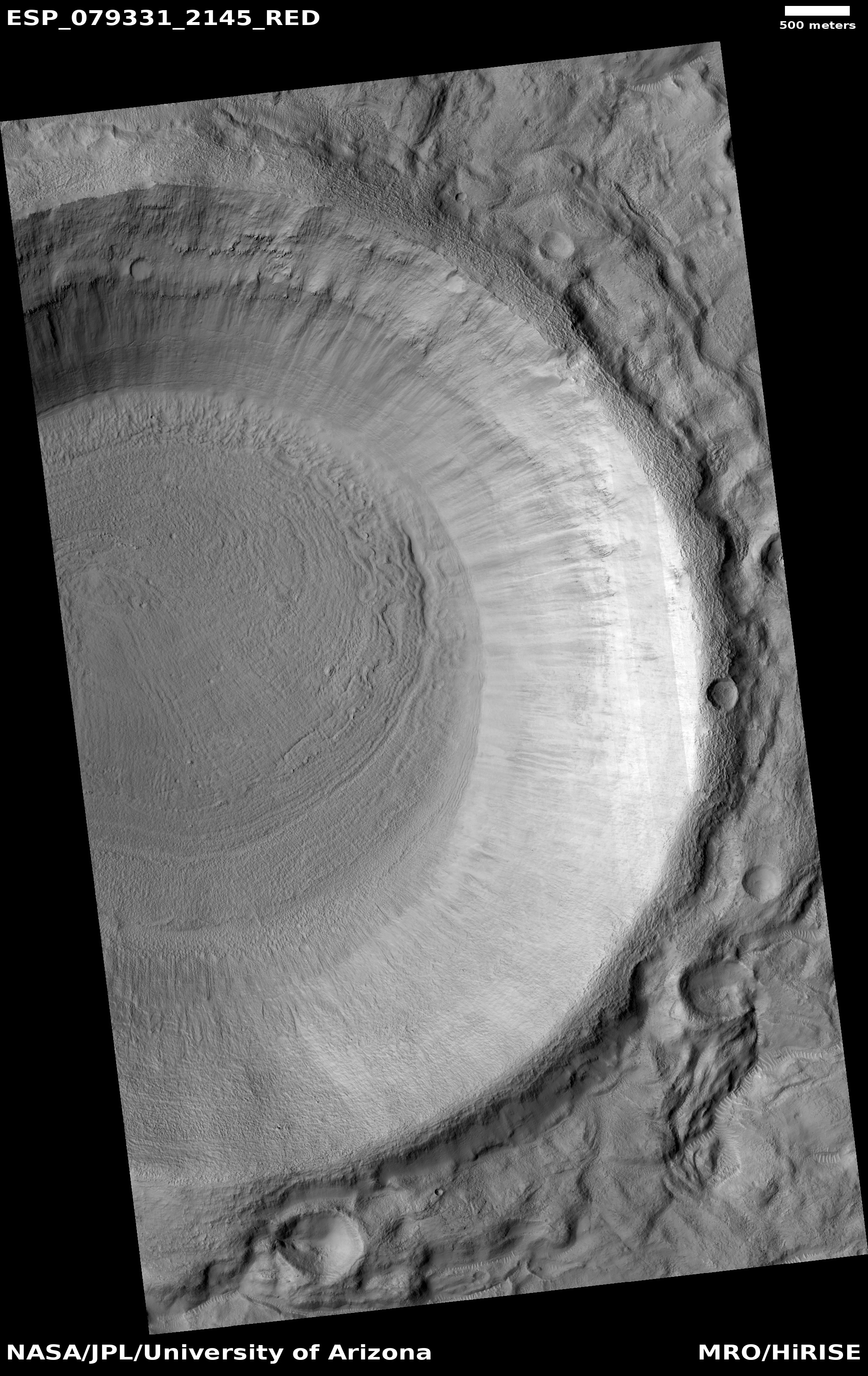
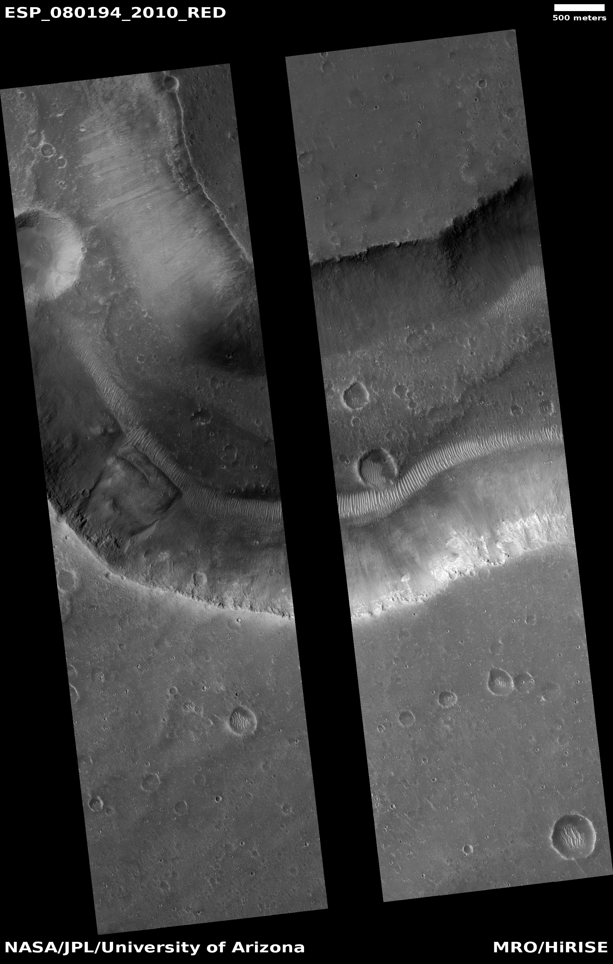
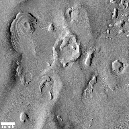
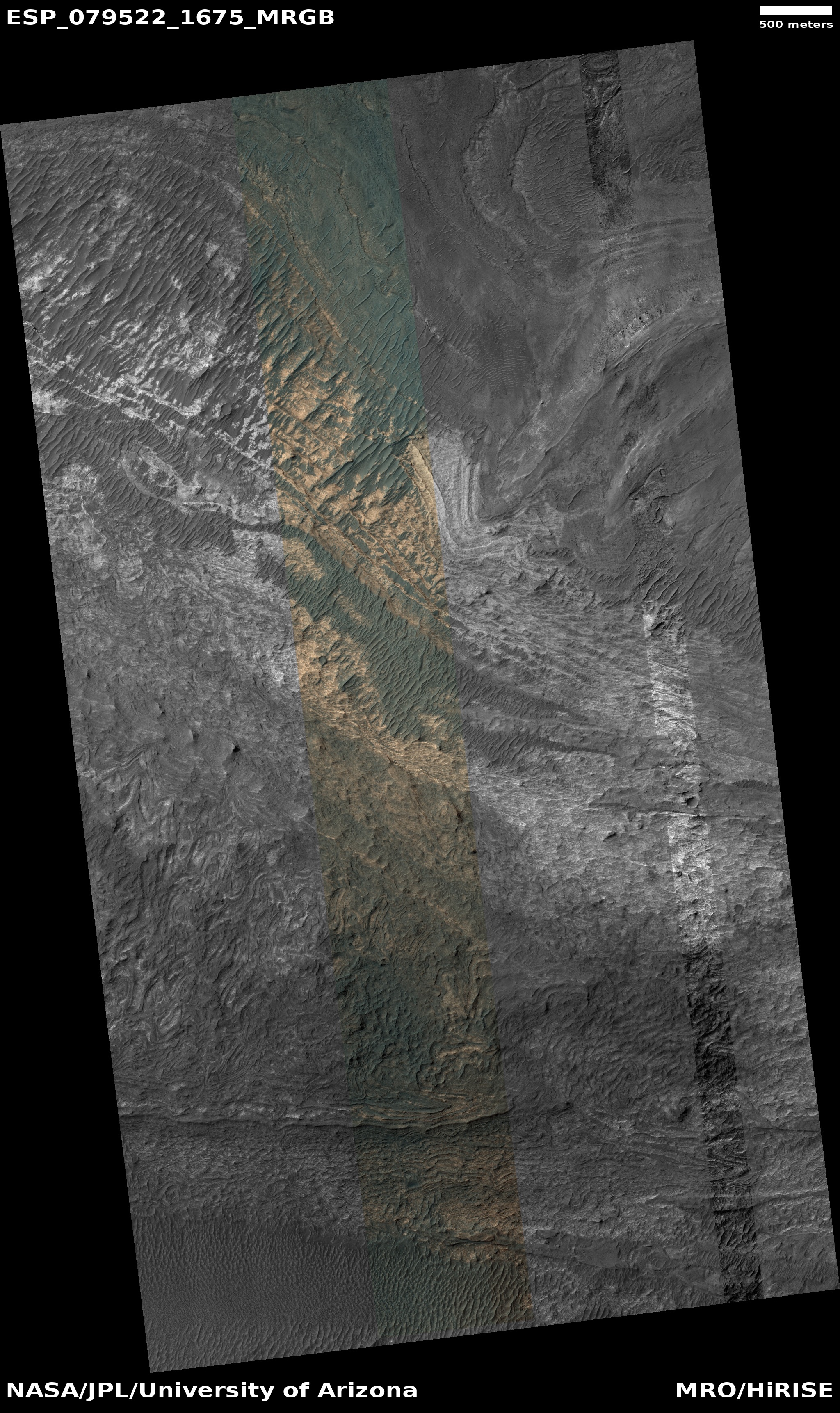
Today’s cool image is also a bafflement. The photo to the right, cropped, reduced, and enhanced to post here, was taken on July 25, 2022 by the high resolution camera on Mars Reconnaissance Orbiter (MRO). The ridges in this picture are labeled by the scientists “Rectilinear Ridges,” but they really do not resemble any of the Martian rectilinear ridge types outlined in this paper [pdf], all of which appear to have a much more pronounced criss-cross pattern.

These ridges however are more meandering, and instead to my eye seem more like inverted channels, ancient channels whose beds became compacted and then became ridges when the less dense surrounding material eroded away. The problem with this conclusion however is the lack of any obvious tributary pattern. If these were once channels where either liquid water or glaciers once flowed, none of them seem to exhibit any drainage pattern. The ridges go in all directions.

The context map below only increases the mystery.
» Read more

InSight still hangs in, barely

InSight's power status as of October 22, 2022

A new update on the status of the Mars lander InSight was released today, showing its power output daily through October 22, 2022. The graph to the right shows this update. From the report:

As of October 22, 2022, InSight’s seismometer is collecting data again after being switched off to conserve energy after a recent dust storm. The lander was generating an average of 280 watt-hours of energy per Martian day, or sol. The tau, or level of dust cover in the atmosphere, was estimated at 1.45 (typical tau levels outside of dust season range from 0.6-0.7).

These power levels are very low, so low I am surprised the science team thought it was able to start the seismometer again. It could be they expect the lander to fail any moment, and decided to maximize the data it can get in the little time it has left.

A press conference is planned for Thursday, October 27, 2022 to provide an update on InSight’s future, as well it appears to describe a recent discovery (likely the exact moment some recent impacts took place) based on data from InSight and images from Mars Reconnaissance Orbiter (MRO). This was already reported in mid-September, but more impacts might have been identified.

It is also possible the MRO images detected some other change on the surface (not an impact) that InSight’s seismometer picked up. If so, the briefing will be far more interesting.

ESA asks member nations to build lander for Franklin Mars rover

In its most recent request for funding from the member nations of the European Space Agency (ESA), the agency has asked the member nations to finance the design and construction of a new lander for its long delayed Rosalind Franklin Mars rover, replacing the Russian lander that had became unavailable due to sanctions resulting from Russia’s invasion of the Ukraine.

According to the BBC (opens in new tab), ESA will request 360 million euros to kickstart work on the new landing system, with additional funds likely needed in subsequent years. ESA has already spent some 1.3 billion euro on the ExoMars program, which also includes an orbiter that has been studying Mars’ atmosphere and surface since 2017. ESA will put the plan in front of delegates of its 22 member states at a ministerial conference in November.

“We will have to wait if the [member states] decide to go forward with the project,” Parker said. “This concept is now proposed as part of the director general’s package within [ESA’s] exploration program for decision at the ministerial [conference].”

If ESA’s member nations agree to this plan, expect the launch of Franklyn to be delayed further. Based on the normal pace in which ESA functions, that lander will take a minimum of five years to design and build (likely much longer). Though ESA is now targeting ’28 for the launch of Franklin, which was supposed to launch this past summer after a two year delay, this plan likely means it will not get off the ground this decade.

Meanwhile, there are now at least a half dozen private companies building lunar landers that could more quickly (and for less money) get a Franklin Mars lander built for ESA. None are in Europe however, which means ESA would rather have this mission delayed years so that it can funnel money to its own contractors..

Bedrock layers in Terby Crater on Mars

Bedrock layers in Terby Crater on Mars
Click for full image.

Cool image to end the week! The picture to the right, rotated, cropped, reduced, and enhanced to post here, was taken by on July 18, 2022 by the high resolution camera on Mars Reconnaissance Orbiter (MRO). It shows the bedrock layers on one of two very large mesas that jut out into the floor of 108-mile-wide Terby Crater.

I want to focus your eye on the spoon-shaped mesa near the top right of the photo. Note how the layers can be seen on both sides, even though the top of the mesa seems to be concave. This is strange and complex geology, made even more fascinating in that the two mesas almost reach the center of the crater floor. Why are they here? Why were they not flattened during impact, like the rest of the crater floor? Or maybe the original crater floor is the mesa top, but if so, why did the rest of the crater interior get eroded away.

The overview map below provides some context, and helps fill in some details, even if it fails to answer any of these questions.
» Read more

InSight status: Barely hanging on

InSight's power status as of October 19, 2022

The science team for the InSight lander on Mars today posted an update on the power the spacecraft’s dust covered solar panels are producing. I have added that data to my on-going graph of these power levels, to the right. From the update:

On October 19, 2022, InSight was generating an average between 275 and 285 watt-hours of energy per Martian day, or sol. The tau, or level of dust cover in the atmosphere, was estimated at 1.5 (typical tau levels outside of dust season range from 0.6-0.7).

The jump in tau level is due to a large dust storm that developed in September more than two thousand miles away in the southern hemisphere. Though it is so far away, that storm put a lot more dust in the atmosphere above InSight, and forced engineers to shut down all but its most essential functions.

That storm is apparently continuing, and might even be growing. If so, the future of InSight is dim indeed. Any further drop in the amount of power it generates daily will likely make it unable to operate at all, and the mission will end.

Frozen lava flows around Martian hills

Martian lava flowing around hills
Click for full image.

Cool image time! The photo to the right, rotated, cropped, reduced, and enhanced to post here, was taken on August 24, 2022 by the high resolution camera on Mars Reconnaissance Orbiter (MRO). It shows the westernmost edge of the Athabasca flood lava plain, thought to be the youngest lava flow on Mars, having covered the area of Great Britain in a matter of weeks 600 million years ago.

This image was a captioned feature yesterday by the MRO science team. As they note:

Although you can’t sail a boat on a sea of lava, hills and craters that stick up higher than the lava flow act like barriers. When a boat is driven through the water, there is a bow wave at the front of the boat, and a wake that trails off behind that indicates which way the boat is moving. In a lava flow, when a hill sticks up, the lava piles up on the upstream side (just like a bow wave) and can leave a wake on the downstream side, so we can tell which way the lava was moving against the stationary hill.

As you can see, every hill has a pile of lava on its northeast slopes, and a wake to its southeast. As the main vent of the Athabasca eruption is to the northeast, about 500 miles away (as shown on the overview map below), the flow direction suggested by the wakes fit the general geography.
» Read more

Inverted river on Mars

Inverted river on Mars

Cool image time! The photo to the right, rotated, cropped, reduced, and enhanced to post here, was taken on May 30, 2022 by the high resolution camera on Mars Reconnaissance Orbiter (MRO). It shows what the scientists label as a “inverted fluvial system”.

Such features are not unusual on Mars. The theory explaining their formation is that this was once a channel where either water or ice flowed, packing the streambed down so that it was more dense than the surrounding terrain. After the flowing material disappeared, the less dense surrounding terrain eroded away, leaving the channel as a meandering ridge.

The location of this inverted channel, as shown in the overview map below, lends some weight to the flowing material being water or ice.
» Read more

Changing slope streaks on Mars

Overview map

Changing slope streaks on Mars
Click for full image.

Cool image time! The photo to the right, cropped and reduced to post here, was taken on July 20, 2022 by the high resolution camera on Mars Reconnaissance Orbiter (MRO). It shows what the scientists have labeled a “Splitting Slope Streak” on a mound/hill near the equator and located almost midpoint between the giant volcano Olympus Mons about 2,000 miles to the east and the almost as big volcano Elysium Mons about 2,500 miles to the west. The white cross on the overview map above marks this location, north of the Medusae Fossae volcanic ash deposit.

The slope streak in question is the biggest and darkest at about 7 o’clock. Slope streaks are a feature unique to Mars that remain as yet unexplained. They are not ordinary avalanches, despite their appearance. They seem to have no effect on the topography, and thus are more a stain on the surface. Moreover, some are bright, some dark, and all happen randomly and fade with time. Some think they may be brine-related, while others link them to dust. No theory explains them completely.

What makes this slope streak interesting is that it is relatively new. Compare it with the picture taken in 2016 below.
» Read more

An icy hollow on Mars

A icy hollow on Mars
Click for full image.

Cool image time! The photo to the right, cropped, reduced, and enhanced to post here, was taken on August 20, 2022 by the high resolution camera on Mars Reconnaissance Orbiter (MRO). It shows a somewhat typical example of the many ice scarps that scientists have identified in MRO pictures.

Though this is not a hard fast rule, most of the ice scarps so far found tend to have the steep cliff on the pole-facing side, with the scarp very slowly retreating towards the equator. In today’s example, the scarp where an ice layer in the cliff wall has been identified is indicated by the white arrow, though three sides of the hollow, on the east, north, and west sides, could all also have exposed ice.

Nor is that the only likely ice at this location at 56 degrees south latitude. The stippled plain surrounding the hollow clearly looks like an eroded ice layer, likely covered with a thin protective coat of dust to protect if from quickly sublimating away. The dark streaks across this surface are likely dust devil tracks.

As documented by the global map below, Mars is like Antarctica, a desert with water ice everywhere.
» Read more

Icebergs of Martian lava

Icebergs of Martian lava
Click for full image.

Cool image time! The photo to the right, cropped, reduced, and enhanced to post here, was taken on July 24, 2022 by the high resolution camera on Mars Reconnaissance Orbiter (MRO). The scientists label this “platy-ridged lava” but to my eye this more resembles lava ice bergs trapped within a now frozen lava stream flowing I think from the northeast to the southwest.

My guess that the flow follows that direction is based on two bits of data. First, the shape of the lava ice flows suggests vaguely a flow to the southwest. The wiggling black ridges inside the streams suggest that these flows occurred in two parts, a stronger wide flow that narrowed as the lava on the edges hardened. When the edges solidified the interior flow scraped against it, forming the wiggling ridges.

Second, the location of this image, as shown on the overview map below, strongly suggests the lava streams flowed to the southwest.
» Read more

Thick flow exiting dramatic canyon on Mars

Thick flow into Mamers Valles on Mars
Click for full image.

Cool image time! The photo to the right, cropped and reduced to post here, was taken on July 24, 2022 by the high resolution camera on Mars Reconnaissance Orbiter (MRO). It shows what the scientists label as a “viscous flow” that has apparently carved the wide curving canyon as it slowly flows into open country to the south.

I would estimate the height of that canyon wall to be around 3,000 feet, though this is a very rough guess. I also image a trail switchbacking up the nose of that canyon wall would make for a truly stupendous hiking experience.

The flow filling the canyon floor appears very glacial, which is not surprising as this canyon is at 37 degrees north latitude, in the mid-latitude band where many glacial features are found. The overview map below provides some more detailed context.
» Read more

Martian crater and mesa sculpted by ancient flow

Martian crater and mesa sculpted by ancient flow
Click for full image.

Cool image time! The picture to the right, rotated, cropped, and reduced to post here, was taken on June 15, 2022 by the high resolution camera on Mars Reconnaissance Orbiter (MRO). It shows a crater whose ejecta has been sculpted to the east into a teardrop-shaped mesa by some ancient flow, coming from the west.

The crater itself is located in one of several outflow canyons draining out from the volcanic Tharsis Bulge into the northern lowland plain of Chryse Planitia, the biggest of which is Valles Marineris. This particular canyon is one of the smaller and is dubbed Ravi Vallis.

The overview map below illustrates why many scientists think the flow that shaped this mesa came from a catastrophic flood of liquid water, billions of years ago.
» Read more

Another “What the heck?” formation on Mars

Another
Click for full image.

Cool image time! The photo to the right, cropped, reduced, and enhanced to post here, was taken on May 28, 2022 by the high resolution camera on Mars Reconnaissance Orbiter (MRO), and shows what the scientists label “unique terrain.”

I have increased the contrast to bring out the details. It appears that we have a flat plain of criss-crossing ridges that in large areas have somehow gotten flattened across their top. Imagine someone laying plaster on a wall and using a scraper tool to smooth the surface, but only partially. In this case on Mars, our imaginary worker only smoothed the surface a little, and only in some areas. To try to come up with a geological process however to explain this seems daunting.

And what created the criss-crossing ridges? The overview map provides only a little help in answering these questions.
» Read more

More glaciers in Mars’ glacier country

Overview map

glacial layering in Clasia Vallis
Click for full image.

Cool image time! The photo to the right, rotated, cropped, and reduced to post here, was taken on June 18, 2022 by the high resolution camera on Mars Reconnaissance Orbiter (MRO). It shows what appear to be layered glacial features on the floor of what at first glance appears to be a crater.

It is not a crater however. The depression in the lower right of this image is the rim and floor of a 77-mile-long meandering canyon on Mars dubbed Clasia Vallis. The red cross in the overview map above marks its location, at 34 degrees north latitude. This channel drains downward from the southern cratered highlands into the 2,000-mile-long mid-latitude strip of mensae terrain that I dub glacier country because almost every hi-res image from this region shows glacial features.

Below is a wider view of Clasia Vallis, taken by the context camera on MRO on March 19, 2014.
» Read more

Zig-zag ridges on Mars

Zig-zag ridges on Mars
Click for full image.

Cool image time! The photo to the right, cropped and reduced to post here, was taken on April 9, 2022v by the high resolution camera on Mars Reconnaissance Orbiter (MRO). It shows a series of parallel zig-zag ridges in a flat, knobby terrain.

I don’t presume to explain this at all. According to one research paper,

This interplana region consists of extensive networks of ridges—the eponymous Aeolis Dorsa—and is interpreted as having formed by topographic inversion of fluvial and alluvial deposits.

Why these ridges zig-zag however does not seem to fit into either a fluvial or alluvial explanation, both of which involve the flow of water. The quote implies these could be inverted stream channels (where the compacted streambed becomes a ridge when the surrounding terrain erodes away), but once again, the distinct zig-zag pattern seems wrong. Rivers meander, but they don’t generally turn right and left so sharply. And why should we see parallel zig-zags? This doesn’t seem to fit with a river channel origin.

The particular location, as shown on the overview map below, is close to the dry Martian equator, on the edge of Medusae Fossae Formation, the largest field of volcanic ash dust on Mars.
» Read more

Above ground and underground Martian drainages

Overview map

Cool image time! Today we are going to zoom into our cool image. The overview map to the right provides us the context. Our target is the small white rectangle inside the small box just below the north rim of 185-mile-wide Newton Crater, located 200 to 800 miles from the southwest edge of the lava plains dubbed Daedalia Planum that flowed down from Mars’s biggest volcanoes.

Newton Crater has a number of interesting features. Only two weeks ago I featured 4-mile-wide Avire Crater in Newton’s western quadrant, long known to have many gullies on its interior slopes as well as glacier features on its floor. Scientists have been monitoring those gullies now for more than a decade to see if they change seasonally, in a attempt to figure out their cause.

Today’s cool image looks at the very intriguing meandering canyons that appear to flow south from Newton’s north rim.
» Read more

Martian layers everywhere!

Layers in Argyre Basin
Click for full image.

Cool image time! The photo to the left, rotated, cropped, and reduced to post here, was taken on June 1, 2022 by the high resolution camera on Mars Reconnaissance Orbiter (MRO). It shows the rim edge to a fifteen-mile-wide canyon, with many apparent layers exposed on the high plateau.

The layers are intriguing in that they suggest several things. First, they give us a glimpse into the top and youngest layers that make up the interior canyon wall. Second, they tell us that erosion has removed much of those top and youngest layers, resulting in the mesas on that plateau.

Finally, the gullies flowing down into the canyon indicate further erosion processes, eating away at the canyon wall over time.

The location of this canyon is also intriguing.
» Read more

1 14 15 16 17 18 35