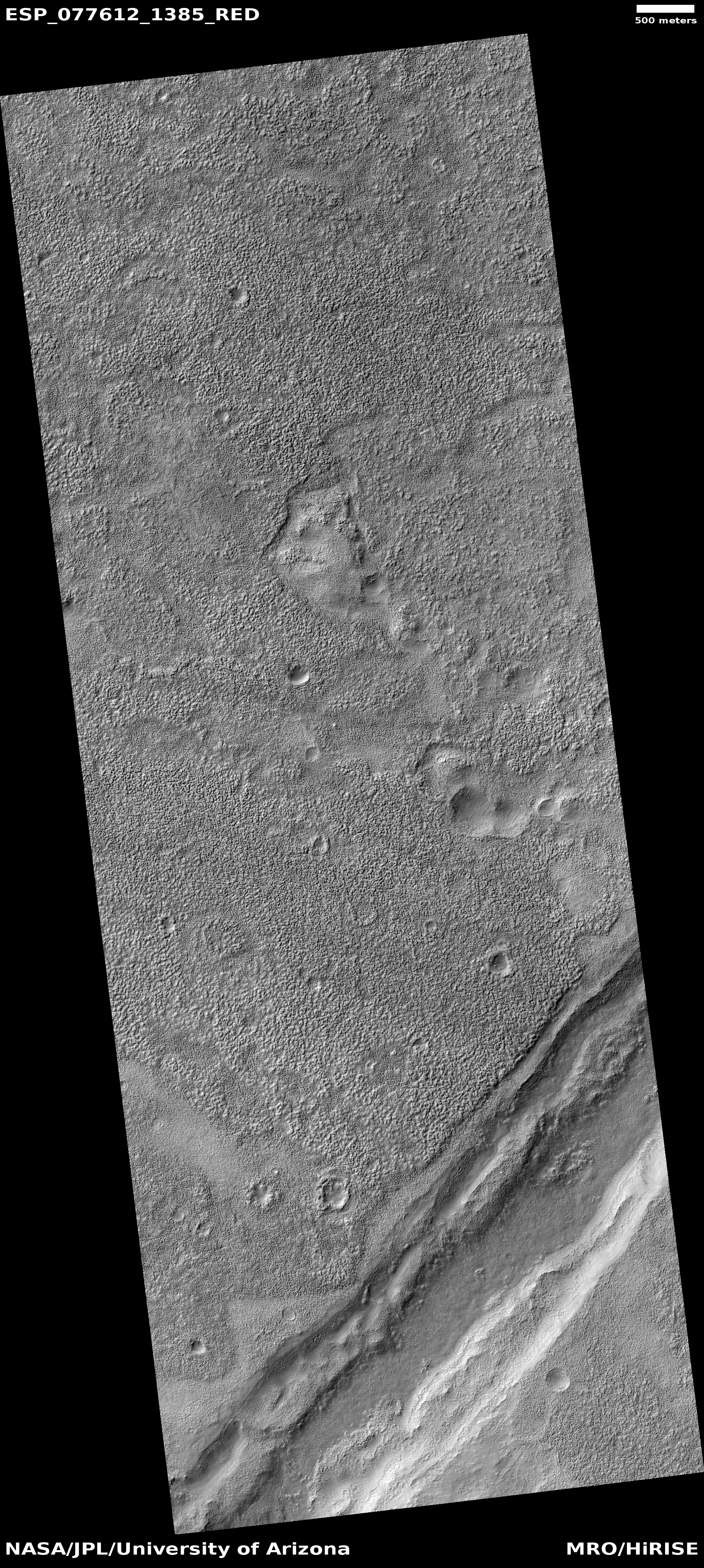
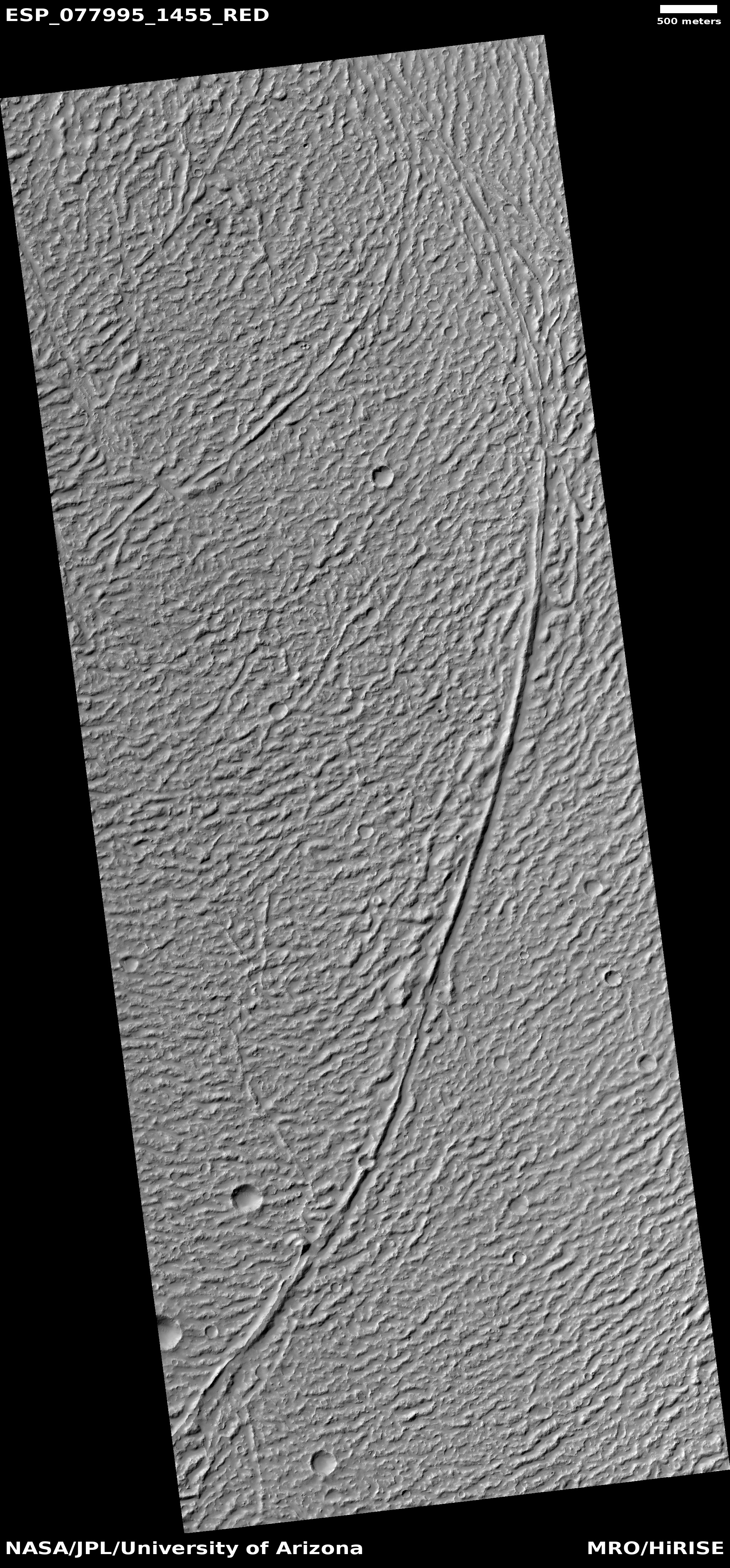
Martian mesas made entirely of dry ice!

Dry ice mesas on Mars
Click for full image.

Time for an especially cool image! The photo to the right, taken on February 13, 2021 by the high resolution camera on Mars Reconnaissance Orbiter (MRO) and cropped and reduced to post here, shows some mesas on the south polar ice cap of Mars.

What makes those mesas cool (literally and figuratively) is that they are thought to be made up entirely of dry ice, part of the thin but permanent frozen carbon dioxide cap in the south. As explained to me by Shane Byrne of the Lunar and Planetary Lab University of Arizona, who requested this image from MRO,

[These mesas are] unusually thick compared to other dry ice mesas (a common landform in the residual ice cap). I only have the lower resolution laser altimeter data to go off for heights here (we may get a stereo pair next year), but from that it looks like 13 meters thick.

That’s about forty feet high, from base to top. In length, the largest mesa on the left is about a mile long and about 1,500 feet wide, on average. And it is made entirely of dry ice!

The red cross on the map below shows the location of these mesas on the south pole ice cap.
» Read more

The flaking and cracked floor of a Martian crater

The flaking and cracked floor of a Martian crater
Click for full image.

Cool image time! The photo to the right, cropped and reduced to post here, was taken on April 1, 2021 by the high resolution camera of Mars Reconnaissance Orbiter (MRO). It shows the central portion of the floor of an unnamed 5-mile-wide crater in northeast corner of Hellas Basin, the deepest large depression on Mars.

The latitude is 33 degrees south, where many glacier features have been identified, especially inside craters.

In this case, the cracked and flaked surface of this crater floor suggests what geologists call exfoliation, “the breaking off of thin concentric shells, sheets, scales, plates, and so on.” On Earth exfoliation generally refers to an erosion process seen on rock faces, though you can see it on other types of materials.

In this Martian crater we appear to be seeing the exfoliation of different ice layers, sublimating away at different rates as they are exposed to the Sun. The layers probably suggest different periods on Mars when snow was falling here, causing the glaciers to grow. The sublimation we see now suggest periods when this region was warmer and the ice was shrinking. Whether we are in such a period now is not yet determined by scientists.

Either way, the photo suggests at least two such cycles, though if we could drill down into this material we would likely find evidence of many more.

Below the fold is a global map of Mars, showing the location of this crater with a red cross in Hellas. The regions surrounded by white borders are areas where many glacial features have been found.
» Read more

Martian glacial run-off?

Mosaic of glacial runoff
For original images click here and here.

Today’s cool image provides us a glimpse at the carved canyons created when the mid-latitude glaciers on Mars were active in the past and slowly flowing downhill into the section of the northern lowland plains dubbed Acidalia Planitia.

The photo to the right is a mosaic of two images taken by the context camera on Mars Reconnaissance Orbiter and rotated, cropped, and reduced to post here. The mosaic shows a region at the very edge of Acidalia Planitia at latitude 43 degrees north.

Below is a close-up of the area in the white box, taken by MRO’s high resolution camera on February 28, 2021, as well as a global map marking the location of this image at the very edge of the glacier country found in the chaos terrain of Deuteronilus Mensae.
» Read more

A crater with wings!

A crater with wings!
Click for full image.

Cool image time! The photo to the right, cropped and reduced to post here, was taken on April 5, 2021 by the high resolution camera on Mars Reconnaissance Orbiter (MRO), and shows a particularly unusual crater in the southern mid-latitudes on the eastern edge of Hellas Basin.

This region east of Hellas is where scientists have spotted many features that suggest buried glaciers. The terraced material inside this crater, as well as the splattered material surrounding it on three sides, are examples of such glacial material. You can also see similar glacial features, though less pronounced, inside the crater to the north.

The global map of Mars below marks the general location of this crater by a blue cross.
» Read more

The layers of Mars’ north pole icecap

The layers of Mars' north pole icecap
Click for full image.

Cool image time! The photo to the right, rotated, cropped, and reduced to post here, was taken on April 1, 2021 by the high resolution camera on Mars Reconnaissance Orbiter (MRO). It shows the high cliff edge of the Martian north polar ice cap, and was taken as part of the springtime monitoring for the numerous avalanches that fall from the icecap’s steep edge every spring.

This particular cliff is probably about 1,000 feet high. I cannot tell if the image captured any avalanches on the very steep north-facing cliff. What struck me about this image however was the terraced layers so visible on the west-facing scarp. You can clearly count about eleven distinct and thick layers, each forming a wide ledge.

Each layer represents a different climate epoch on Mars when the ice cap was growing, with new snow being deposited.
» Read more

A Martian mud volcano

A Martian mud volcano?
Click for full image.

Cool image time! The photo to the right, rotated, cropped, and reduced to post here, was taken on January 6, 2021 by the high resolution camera on Mars Reconnaissance Orbiter (MRO). It shows a distinct conelike knob in an area of the northern lowland plains of Mars dubbed Acidalia Mensa.

According to this paper [pdf], this is possibly a mud volcano.

Bright pitted cones are common in the northern plains of Mars and have been documented to occur in numerous locations including Acidalia Planitia. Various interpretations of these features have been
proposed but growing consensus in recent literature has favored mud volcanism as the most likely formation mechanism. Mud volcanoes are provocative targets for exploration because they bring to the surface sedimentary materials otherwise inaccessible by normal surface exploration and can aid in reconstructing the sedimentary history of the northern plains. Also, by sampling fluids and sediments from deep in the Martian crust, mud volcanoes may be among the best places to search for ancient and extant life.

A previous cool image post, “Baby volcanoes on Mars”, showed another example in the same general area of Mars.

Though this conclusion is not yet confirmed, the multi-layered apron that surrounds the cone certainly suggests repeated eruptions of muddy water over time.

Scientists have taken many images of this area and cone using MRO’s context camera. (See this image as and example.) All show a very rough terrain, with cracks, fissures, and many smaller cones and knobs. This particular knob however dominates the landscape as one of the largest features. The aprons around it are darker, and appear to have been overlain on top of the nearby rough ground.

If such cones are mud volcanoes, they represent a geological process that is pretty much unique to Mars. There are some comparable features on Earth, but they are rare and do not match exactly.

Martian volcanic eruption thought to be only 50,000-210,000 years old

Overview map

Using Mars Reconnaissance Orbiter (MRO) images scientists now believe they have located a volcanic eruption on Mars that could have erupted violently as recently as only 50,000 years ago, and is located deep within Mars’ volcano country. The overview map to the right indicates the location of this volcanic with the blue cross. The red dots surrounded by white ovals are distinct quakes that InSight has detected. From their paper’s abstract:

Stratigraphic relationships indicate a relative age younger than the surrounding volcanic plains and the [nearby] Zunil impact crater (~0.1–1 [million years]), with crater counting suggesting that the deposit has an absolute model age of 53 ± 7 to 210 ± 12 [thousand years]. This young age implies that if this deposit is volcanic then the Cerberus Fossae region may not be extinct and that Mars may still be volcanically active. This interpretation is consistent with the identification of seismicity in this region by the [InSight] lander, and has additional implications for astrobiology.

The Cerberus Fossae region is a series of long fissures that scientists think were created when the underground magma pushed up, stretched the surface, and thus caused it to crack. This particular feature suggests that when the ground cracked it sometimes also did so in conjunction with a volcanic eruption.

Below is a zoomed-in context mosaic, taken from figure 1 of the above paper, showing the feature itself and the surrounding terrain.
» Read more

Fresh washes on Mars?

Meandering fresh wash on Mars?
Click for full image.

Cool image time! The photo to the right, cropped and reduced to post here, was taken on January 29, 2021 by the high resolution camera on Mars Reconnaissance Orbiter (MRO). It shows what the science team labels as “Fresh Shallow Valleys”. The section I have focused on shows a particularly interesting meander next to a small crater. The full image shows additional similar channels to the north, with one draining into a larger 3.7 mile wide crater.

The location is in the southern cratered highlands, at about 41 degrees south latitude, where much evidence of buried glacial features are found. That certainly is what we appear to see here. In fact, the wider view afforded by MRO’s context camera reveals many more such channels. That wider view also shows a much larger 18-mile-wide crater just to the north that appears filled with buried ice.

That the scientists label these fresh suggests they think they are relatively young, probably dating from when the most recent cycle of glacial growth probably ended. This would make them about 6 million years ago, based on this paper [pdf] and the second figure from that paper below.
» Read more

A river of lava on Mars as long as the Columbia

Lava flow in Kasei Valles
Click for full image.

I’ve said it before and I’ll say it again. Mars is strange, Mars is wonderful, but above all, Mars is alien. Today’s cool image illustrates this saying quite nicely.

The photo to the right, cropped and reduced to post here, was taken on February 1, 2021 by the high resolution camera on Mars Reconnaissance Orbiter (MRO) and was simply labeled “Sacra Sulci Lava”. Sacra Sulci is a section of the Kasei Valles canyon that runs from the north rim of Valles Marineris north about 600 miles where it turns east for about 400 miles to drain out into the northern lowlands plains of Mars. Sacra Sulci is the region where that valley narrows and then turns east.

Apparently the flat smoother areas on the east and south on this image that rise about 60 feet above the surrounding terrain and that also seem to flow around mesas and into canyons are believed to be the edge of a massive lava flow that occurred about 150 to 200 million years ago and drained through Kasei Valles, just like water.

What makes this puzzling, however, is that everything I had read previously about Kasei Valles said that it was thought to have been formed from catastrophic floods of water on early Mars, when the planet was warmer and wetter. In fact, I had posted previously about this theory, and included the map below, taken from figure 8 of this paper [pdf], showing part of the process that some scientists believe occurred.
» Read more

The crack that splits the giant volcanoes on Mars

Source of Arsia Mons rille
Click for full image.

Cool image time! In the April download of new images from the high resolution camera on Mars Reconnaissance Orbiter (MRO) was the photo to the right, taken on February 23, 2021 and cropped and reduced to post here, of what was labeled as “Source Region of Possible Rille on South Flank of Arsia Mons.”

Arsia Mons is the southernmost of the string of three giant volcanoes that sit between Mars’ biggest volcano to the west, Olympus Mons, and Mars’ biggest canyon to the east, Valles Marineris. This depression is on the mountain’s lower southern flank, and likely shows an ancient resurgence point where lava once flowed out from beneath the ground to form a rill meandering to the southwest. Today there is no visible resurgence. The floor of the depression appears to be filled with sand and dust, with the surrounding slopes spotted with scattered boulders.

What makes this particular image more interesting is how, when we take a very wide view, it reveals one of the most dramatic geological features on Mars, the 3,500 mile-long crack that caused these three volcanoes, and is actually not obvious unless you know what to look for.

So we need to zoom out. Let us first begin with a mosaic of three wider MRO context camera images, showing the entire rille and the immediately surrounding terrain.
» Read more

Twisted taffy in the basement of Mars

Taffy on Mars
Click for full image.

Cool image time! The photo to the right, taken on March 7, 2021 by the high resolution camera on Mars Reconnaissance Orbiter (MRO) and cropped and reduced to post here, shows us an example of one of Mars’ strangest and most puzzling geological features, dubbed banded or “taffy-pull” terrain by scientists.

Taffy-pull terrain has so far only been found within Hellas Basin, Mars’ deepest impact basin and what I like to call the basement of Mars. Because of the lower crater count in this terrain scientists consider it relatively young, no more than 3 billion years old, according to this 2014 paper, which also notes

The apparent sensitivity to local topography and preference for concentrating in localized depressions is compatible with deformation as a viscous fluid.

At the moment what that viscous fluid was remains a matter of debate. Many theories propose that ice and water acting in conjunction with salt caused their formation, similar to salt domes seen on Earth. Other propose that the terrain formed from some kind of volcanic or impact melt process.

Almost all of the taffy terrain on Mars has been found in the deepest parts of Hellas Basin in a curved trough along its western interior, as shown by the light blue areas in the overview map below.
» Read more

Martian pit on top of Martian dome

Dome with pit
Click for full image.

Cool image time! The photo to the right, cropped and reduced to post here, was taken on March 7, 2021 by the high resolution camera on Mars Reconnaissance Orbiter (MRO) and was simply labeled “Pit on Top of Dome in Promethei Terra.”

The cropped section to the right shows one of two such pits visible on the entire image. Promethei Terra is a large 2,000 mile long cratered region due east from Hellas Basin, the deepest large region on Mars.

What caused these pits? The known facts provide clues, but do not really solve the mystery.

First, this image is located in the southern cratered highlands at 45 degrees south latitude. Thus, it is not surprising that it resembles similar terrain in the northern lowlands that suggests an ice layer very close to the surface.
» Read more

Study: increase in seasonal Martian streaks after 2018 global dust storm suggests dust not water is their cause

Map of Mars showing location of new linneae after 2018 global dust storm
Click for full image.

The uncertainty of science: A just-published survey of Mars following the 2018 global dust storm found that there was a significant increase in the seasonal dark streaks that scientists call recurring slope lineae, providing more evidence that these streaks are not caused by some form of water seepage but instead are related to some dry process.

The map to the right is figure 2 from that paper. The white dots show the candidate lineae that appeared following the 2018 global dust storm. About half were new streaks, not seen previously.

From the paper’s conclusion:
» Read more

Polygons and an inexplicable depression in ancient Martian crater floor

Polygons and an inexplicable depression in ancient Martian crater
Click for full image.

Cool image time! The photo to the right, cropped to post here, was taken on February 26, 2021 by the high resolution camera on Mars Reconnaissance Orbiter (MRO) of a small section of the floor of 85-mile-wide Galilaei Crater.

The main focus of the image is the polygonal cracks that cover the flat low areas of the crater floor, interspersed randomly by small mesas and shallow irregular depressions. The depression in this particular image is especially intriguing. It to me falls into my “What the heck?!” category, for I can’t imagine why among this terrain of polygons and pointed mesas there should suddenly be an irregularly shaped flat depression with a completely smooth floor that has no cracks at all.

The polygons are less puzzling. Galilaei Crater is very old, its impact thought to have occurred about 4 billion years ago. Though it sits at 5 degrees north latitude, practically on the Martian equator and thus in what is now Mars’ most arid region, scientists believe that once there was a lot of liquid surface water here. The overview map below illustrates this.
» Read more

Bumps and holes in the Martian mid-latitudes

Bumps and holes in the Martian mid-latitudes
Click for full image.

Today’s cool image to the right, taken on January 6, 2021 by the high resolution camera on Mars Reconnaissance Orbiter (MRO) and cropped and reduced to post here, focuses on what appears to be a volcanic bulge on the southeastern edge of the great Tharsis Bulge, home to Mars’ biggest volcanoes.

The terrain gives the appearance of hard and rough lava field, ancient and significantly scoured with time. The bumps and mounds suggest nodules that remained as the surrounding softer material eroded away. The holes suggest impact craters, but their relatively few number suggest that this ground was laid down in more recent volcanic events after the late heavy bombardment that occurred in the early solar system about 4 billion years ago. Since it is thought that the big Martian volcanoes stopped being active about a billion years ago, this scenario seems to fit.

However, the terrain also has hints of possible glacial features, as seen in the large crater-like depression in the image’s center. Below is a zoom in to that crater to highlight the flowlike features in its southern interior.
» Read more

Glacial layers in a northern crater on Mars

Crater filled with many layered glacial features
Click for full image.

Cool image time! The photo to the right, cropped to post here, was taken by the high resolution camera on Mars Reconnaissance Orbiter on March 6, 2021, and shows a mid-latitude crater in the northern lowland plains of Mars with what appear to be layered glacial features filling its interior.

The theory that scientists presently favor for explaining many of the features we see on Mars is based on many climate cycles caused by the wide swings the planet routinely experiences in its obliquity, or rotational tilt. When that tilt is high, more than 45 degrees, the mid-latitudes are colder than the poles, and water ice sublimates southward to those mid-latitudes to fall as snow and cause active glaciers to form. When that obliquity is low, less than 20 degrees, the mid-latitudes are warmer than the poles and that ice then migrates back north.

Such cycles, which are believed to have occurred many thousands of times in the last few million years, will place many layers on the ground in both the mid-latitudes and at the poles. The layers in this crater hint at this.

The overview map below gives some further context.
» Read more

Spring arrives on the northern polar cap of Mars

Buzzell dunes and pedestal crater near the Martian north polar ice cap
Click for full image.

Cool image time! It is now spring in the northern hemisphere of Mars, and the first bits of sunlight are finally reaching its north polar ice cap. During the winter, as happens each Martian year, that polar cap of water ice gets covered by a thin mantle of dry ice no more than six feet thick. Moreover, this mantle doesn’t just cover the ice cap, it extends south as far as about 60 degrees latitude, covering the giant sea of dunes that surrounds the ice cap.

When spring comes that mantle begins sublimate away, with its base first turning to gas. When the pressure builds up enough, the gas breaks out through the frozen mantle’s weakest points, usually the crest or base of dunes or ridges, leaving behind a dark splotch caused by the material thrown up from below that contrasts with the bright translucent dry ice mantle.

Each year for the past decade scientists have been using the high resolution camera on Mars Reconnaissance Orbiter (MRO) to monitor this sublimation process. The photo above, taken on February 24, 2021 and cropped, enlarged, and brightened to post here, marks the start of this year’s monitoring program. Dubbed informally “Buzzell” by Candice Hansen of the Planetary Science Institute in Arizona, it shows dunes with a round pedestal crater just right of center. Though almost everything when this picture was taken is still covered by that dry ice mantle, in the lower left is a single splotch, the first breakout of CO2 gas that marks the beginning of the annual disappearance of this dry ice.

Last Martian year I repeatedly posted images of Buzzell to illustrate this annual process. The second image below was taken on April 4, 2019, at about the same comparable time in spring.
» Read more

Evidence of glaciers in the Martian equatorial regions?

Equatorial crater with glacial features?

Cool image time! The photo to the right, cropped and reduced to post here, was taken on February 2, 2021 by the high resolution camera on Mars Reconnaissance Orbiter (MRO) and was labeled as “Exhumed Craters Exhibiting Concentric Fill”.

The term “Concentric Fill” is used by planetary scientists to mark glacial-type features frequently found inside craters at latitudes greater than 30 degrees latitude. This crater however is at 22 degrees north latitude, too close normally to the equator to expect a buried glacier inside it. Any ice at such a latitude is expected to be underground and well protected. A debris covered glacier would likely sublimate away, which I think is why the scientists labeled this “exhumed.” Though there are the concentric features near its inside rim as well as covered by the sand dunes on the crater’s floor, they are assuming this is only evidence of past ice, no longer there. This assumption is strengthened by the splattered but eroded nature of the surrounding terrain. Such splats are typical of high latitude impacts in regions with ample buried ice. The eroded nature of this splat however suggests it is very old and has likely lost its ice.

Then again, this is an assumption.
» Read more

A lonely dry lava spring on Mars

A lonely dry lava spring on Mars
Click for full image.

Today’s cool image from Mars takes us to the southern flank of the giant volcano Pavonis Mons. The photo to the right, rotated, cropped, and reduced to post here, shows what appears to be a volcanic vent from more than a billion years ago when it is believed Pavonis was actively erupting. The picture was taken on March 2, 2021 by the high resolution camera on Mars Reconnaissance Orbiter (MRO). The grade is mostly downhill to the east and south east.

It is very possible that this is the resurgence of a lava tube, the point where the underground flow either emerged to the surface or got so close to the surface that the ceiling was thin enough to later collapse, creating this depression. No pits or skylights are visible in this high resolution picture, however, so whether there is an underground lava tube here is not known, an unknown that is amplified by the wider MRO context camera image below.
» Read more

The start of avalanche season at Mars’ north pole

A narrow ridge with avalanches
Click for full image.

Every spring for the last seven Martian years scientists have eagerly aimed the high resolution camera on Mars Reconnaissance Orbiter (MRO) at the steep 1,500 to 3,000 foot high scarp at the edge of northern polar ice cap in order to capture images of what is Mars’s most spectacular annual event, the occurrence of tens of thousands springtime avalanches along that scarp.

Well, spring has returned to the northern hemisphere on Mars, and the scientists have begun another monitoring campaign. The photo to the right, cropped to post here, was taken on March 7, 2021 by MRO. It shows a particularly dramatic part of that scarp, a place where the scarp separates two curved alcoves and is thus narrowed down to a ridge about 1,000 feet high.

The nose of the ridge is sloping downward to the northwest, so the horizontal bands on its crest are actually evidence of older and older layers exposed as the elevation drops. The blue and black markings on the left slope are likely evidence of this season’s first avalanches, or might even be avalanches occurring as the picture was snapped! As explained to me by Shane Byrne of the Lunar and Planetary Lab University of Arizona during the last Martian avalanche season,

On Mars half of the images we take in the right season contain an avalanche. There’s one image that has four avalanches going off simultaneously at different parts of the scarp. There must be hundreds to thousands of these events each day.”

The overview map below shows the location of this picture, as well as all the other places the scientists have routinely monitored in the fourteen-plus Earth years since MRO reached Mars orbit.
» Read more

Lava flooded mountains on Mars

Lava-flooded mountains on Mars
Click for full image.

Overview map

Today’s cool image to the right, rotated, cropped, and reduced to post here, was taken in January 2012 by the context camera of Mars Reconnaissance Orbiter (MRO). The location is a small section of the Tartarus mountain range that is cut by the Cerberus Fossae fissures, all located in Elysium Planitia, the large volcanic lava plain that lies between Mars’ big volcanoes. The white cross on the overview map below marks the location of the photo.

I picked this photo because it quickly shows us in one picture many of the typical features one finds in that lava plain.

For example, the distinct fissure that cuts across the mountains near the top of the picture is the northernmost large fissure of Cerberus Fossae. In my initial post on Cerberus I mistaken thought its large and many hundreds of miles-long fissures might be evidence of underground lava tubes. Since then I have learned while the depressions may signal underground voids, they are not a lava tubes but graben, cracks formed by the movement of the terrain on each side. The cracks opened when past volcanic activity caused the ground to swell upward, stretching and splitting it.

The dark splotch in the flat area just south of the fissure remains me of the maculae found in these lava plains to the west of Olympus Mons, splotches that for still undetermined reasons dust devils like to congregate, blowing off the red dust so that the dark basalt lava becomes visible. No high resolution image of this spot has yet been taken, so this is a pure guess on my part.

The mountains near the bottom of the photo illustrate the ancient lava flood that inundated these mountain peaks. The white box shows the area covered by the recent MRO high resolution image that I include below.
» Read more

Mars’ icy high latitudes

Mars' icy high latitudes
Click for full image.

Cool image time! The photo to the right, rotated, cropped, and reduced to post here, was taken on November 29, 2020 by the high resolution camera on Mars Reconnaissance Orbiter (MRO). Labeled simply as “periglacial survey,” it is one of almost two hundred such images taken by MRO over the years, almost all of which are in the high latitudes above 60 degrees, with most being in the southern hemisphere. Most appear to be close to or above Mars’s Arctic Circle, which means these are locations that will see little or no sunlight for a portion of the year.

I have been unable to contact the scientists doing this survey, so I will have to make an educated guess as to its purpose and goals. “Periglacial” refers to the outer fringes or margin of a glacier or large ice sheet. Thus, in the context of this survey, the scientists appear to be studying places where they think the Martian high latitude ice sheets are beginning to sublimate away. Today’s photo is a good example. It is located at 67 degrees south latitude, in the southern cratered highlands but in an area that appears to be relatively free of craters. Instead, the terrain appears somewhat flat with only periodic depressions and scarps. The MRO context camera photo below of the same area, rotated, cropped, and expanded to post here, illustrates this.
» Read more

Perseverance as seen from orbit

Perseverance landing site prior to landing
Click for full image.

Perservance on the ground
Click for full image.

Cool image time! The two photos to the right show the landing site for the Perseverance rover in Jezero Crater on Mars. The first image was taken in 2016 by the high resolution camera on Mars Reconnaissance Orbiter. The second image was made available today in the monthly release of photos taken that camera on MRO.

The arrow points to a small white streak that is not visible in the 2016 photo. A closer look reveals that the streak is actually two fanlike white deposits expanding outward in opposite directions from a central point.

What we are seeing are the exhaust fans blown onto the Martian surface by the retro-jets on the Sky crane that was lowering Perseverance to the ground. The rover was put down at the centerpoint, and was still at that spot on March 2nd when this photo was acquired.

The highest resolution version of this image requires special software, so in this version you cannot see the rover itself. Nor can you see the Sky crane after it crashed landed or the parachutes.

The new photo was taken one week after the first high resolution image from MRO, as part of what will become a routine periodic monitoring of the site, along with obtaining mapping information for picking the rover’s upcoming route They will also probably use both images to try to locate both the Sky crane and parachutes, on the ground.

Colorful mesa in the Martian northern lowland plains

Colorful mound in Martian northern lowland plains
Click for full image.

Cool image time! The photo to the right, rotated and cropped to post here and taken on January 15, 2021 by the high resolution camera on Mars Reconnaissance Orbiter (MRO), shows the colorful top of a small mesa in the northern lowland plains of Mars and about 300 miles north of the planned landing zone for Europe’s Franklin rover, scheduled to launch in 2022.

What makes this mesa stand out is the bright and colorful areas on its slopes. The colors are false, but they indicate [pdf] certain things. The yellow is likely dust covered rock. The pinkish rock is also likely dust-covered, but made up of coarser material. The bluish strip running along the mesa’s northern slope is possibly frost or ice, not unlikely as this mound is at 25 degrees north latitude and was taken during winter. The slope faces north, which would put it in shadow much of the time during winter.

The colors however only hint at what is there.
» Read more

Two pits at opposite ends of Mars’ big volcanoes

Overview map

Regular readers of Behind the Black know that since 2018 I have regularly documented all the images of pits taken by the high resolution camera on Mars Reconnaissance Orbiter (MRO). (See my last pit post in January for a full list of these previous articles.) The black dots on the map to the right shows the location of all the pits near the volcanoes Arsia and Pavonis Mons that have so far been highlighted here.

The two white dots are the two most recent MRO pits, and are the subject of today’s cool image. They also happen to be the farthest north and south pits so far documented. The southernmost pit, which I am saving till last, is the most interesting.
» Read more

Very peculiar flow features on Mars

Peculiar flows on Mars
Click for full image.

Today’s cool image focuses on one of the weirdest flow features I have yet seen on Mars. The first photo to the right, rotated and cropped to post here, comes from a January 27, 2021 picture by the high resolution camera on Mars Reconnaissance Orbiter (MRO). This cropped section focuses on the middle of three such weird features, two close flows heading downhill on the interior rim of very eroded 28-mile-wide crater. For some reason the flows also have depressions on their crowns. The depressions almost look like someone carved them out with a spackling spatula. In fact, the MRO science team agrees, labeling this image as “Spatulate Depressions with and without Upslope Gullies.”

The second image to the right shows a wider crop of the same picture, and explains the reason for the last half of that label.
» Read more

Martian glaciers flowing off interior walls of Renaudot Crater

Overview map

Cool image time! In the March 1st image release from the high resolution camera on Mars Reconnaissance Orbiter (MRO) were two pictures covering sections of the interior rim of 40-mile-wide Renaudot Crater, located in the northern lowland plains of Mars north of the region I dub Mars’ glacier country.

The map to the right provides the context. The two red boxes in Renaudot Crater show the location of the two images below, with the first being the one to the left. Located at about 42 degrees north latitude, we should expect to see evidence of ice and glacial features here, and that is exactly what both photos show.
» Read more

Baffling ridges on Mars

Baffling ridges on Mars
Click for full image.

Today’s cool image is one of my “what the heck?” photos. The picture to the right, cropped and reduced to post here and taken on September 3, 2020 by the high resolution camera on Mars Reconnaissance Orbiter (MRO), shows a strange dune field of many parallel long dunes, cross-cut by larger ridges.

Are the larger ridges dunes? Or are they some form of volcanic or tectonic ridge, which is also very typical of this region, called Tempe Terra and located in the transition zone between the southern cratered highlands and the northern lowland plains?

Or are they eskers, ridges frequently found in places that were once covered by glaciers? At 35 degrees north latitude, it would not be surprising to see glacial features here, but as far as I can tell, the full image has no obvious such features.
» Read more

Ice-filled crater in Mars’ glacier country

Crater filled with ice
Click for full image.

Cool image time! The photo to the right, cropped and reduced to post here and taken on January 7, 2021 by the high resolution camera on Mars Reconnaissance Orbiter (MRO), provides us a perfect example of the kind of glacial feature that scientists find routinely in the 30 to 60 degree mid-latitude bands on Mars. In this case the crater is in the northern reaches of a chaos region dubbed Nilosyrtis Mensae, the easternmost mensae region of what I dub glacier country on Mars.

When first identified scientists named this concentric crater fill, a purposely vague term that is only descriptive because they then did not know what it was made of, though they had their suspicions that it was buried glacial ice. Since then radar data has routinely confirmed that there is ice in such filled craters, making this particular glacial feature one of the most prevalent in those mid-latitude bands.

You can see a quite similar ice-filled crater, also in Nilosyrtis, in an earlier post from October 2020. While that earlier crater was on the southern edge of Nilosyrtis, today’s crater is about 300 miles almost due north, near the region’s northern fringe. In between are lots of similar glacial features, sometimes in craters, sometimes flowing off the slopes of mesas, and sometimes flow features in the open canyons between.

Layers upon layers of Martian volcanic ash

Layers upon layers of Martian volcanic ash
Click for full image.

Today’s cool image provides I think a hint at the vast amount of time that has passed on Mars, allowing uncounted major events to occur which each lay down a bit of the geological history, a history that is now piled up on the surface so deeply that it will take decades of research to untangle it.

The photo to the right, cropped and reduced to post here, was taken on December 23, 2020 by the high resolution camera on Mars Reconnaissance Orbiter (MRO). It shows the layered nature of the Medusae Fossae Formation, the largest volcanic ash deposit on Mars (about the land area of India) and thought by some to be the source of most of the dust across the entire red planet.
» Read more

1 18 19 20 21 22 32