Cost for Mars 2020 rover up 15%

Because of cost overruns in building three instruments for the Mars 2020 rover, its total budget will rise by 15%, forcing NASA to trim budgets elsewhere in its planetary program.

There are small efficiencies to be gained internally in Mars 2020, Glaze says, which, like its predecessor Curiosity, is being developed by NASAโ€™s Jet Propulsion Laboratory (JPL) in Pasadena, California. Some work can be postponed, some timelines tightened; the end of the Opportunity rover, which expired late last year on Mars, will help. But it is expected the costs will largely be borne by trims to the operations of existing Mars missions and funds the agency sets aside for future missions, including the return of the rock samples that Mars 2020 will collect. โ€œWe tried to spread it so no one is feeling all of the pain,โ€ Glaze says.

For a government program costing almost $2.5 billion, this overage is remarkably small. What is more significant is that the rover appears on schedule for launch in July 2020.

1 comment

Mars likely has many large and extensive cave systems

Mamers Valles

More caves on Mars! This week the Lunar and Planetary Institute and the Johnson Space Center are jointly holding the 50th Lunar and Planetary Science Conference in Texas. I have been going over the program, and will be posting reviews of some of the more interesting results all this week.

We begin with caves, which should not be surprising to my regular readers. As a caver who also knows their value for future space colonists, I am always attracted to new discoveries of cave passages on other worlds. Today’s however is a doozy.

The image to the right is of Mamers Valles on Mars, what scientists have dubbed a fretted valley, a common feature in the transition zone between the low altitude northern plains and the southern highlands. It comes from a paper [pdf] with the typically unexciting scientific title, “Fretted channels and closed depressions in northern Arabia Terra, Mars: Origins and implications for subsurface hydrologic activity.”

What the scientists really means here is that their research strongly suggests that Mars has a very large and very extensive number of underground drainage systems, which have caused collapses on the surface that often resemble meandering river canyons, such as seen above. As they explain:
» Read more

3 comments

Curiosity has another computer crash

Since March 6 all activity from Curiosity seemed to stop, with no images and no science team updates. The reason? The rover had experienced another computer crash and reboot:

Curiosity experienced a computer reset on its Side-A computer on Wednesday, March 6, 2019 (Sol 2,339), that triggered the rover’s safe mode. This was the second computer reset in three weeks; both resets were related to the computer’s memory.

The mission team decided to switch from the Side-A computer back to the rover’s Side-B computer, which it operated on for most of the mission until November of 2018. Side-B recently experienced its own memory issue; the team has since further diagnosed the matter, reformatting the Side-B computer to isolate areas of “bad” memory. As of today, Curiosity is out of safe mode, and the team is configuring the rover for new science operations in the clay unit. Curiosity is expected to return to science operations as early as Wednesday.

This news is worrisome. The track record for spacecraft with increasing computer problems is that they never get better. Instead, the problem steadily worsens until operations become limited or even impossible. In the meantime engineers work wonders to extend the mission, but in the end this is a battle they appear to always lose.

We are beginning to see this pattern with Curiosity. Both of its computers have now experienced problems. It appears they have a better handle on the problems with the back-up computer (Side-B), so that is why they have switched back to it. Should its own memory issues continue to deteriorate however the rover will be in serious trouble, as the Side-A computer has proven to be very unreliable.

7 comments

New analysis supports catastrophic floods and intermittent ocean on Mars

The intermittent ocean at the outlet to Marineris Valles

A new analysis of Martian data once again suggests that an intermittent ocean once existed in the planet’s northern hemisphere, and that it was fed by catastrophic floods coming down from the volcanoes through Marineris Valles.

โ€œOur simulation shows that the presence of the sea would have attenuated cataclysmic floods, leading to shallow spillovers that reached the Pathfinder landing site and produced the bedforms detected by the spacecraft,โ€ said [lead scientist Alexis Rodriguez].

The teamโ€™s results indicate that marine spillover deposits contributed to the landscape that the spacecraft detected nearly 22 years ago, and reconcile the mission’s in situ geologic observations and decades of remote-sensing outflow channel investigations.

The sea bears an uncanny resemblance to the Aral Sea on Earth in that in both instances they lack distinct shoreline terraces. Its rapid regression over shallow submerged slopes resulted in rates of shoreline front retreat too fast for the terraces to form. The same process could partly account for the long-recognized lack of northern plains shorelines.

โ€œOur numerical simulations indicate that the sea rapidly became ice-covered and disappeared within a few thousand years due to its rapid evaporation and sublimation. During this time, however, it remained liquid below its ice cover,โ€ said PSI Senior Scientist Bryan Travis, a co-author in the paper.

The map above shows the outlet region to the west and north of Marineris Valles. (The paper from which it is adapted is available on line here.) It shows that inland sea, created by the catastrophic floods. Because it sits at a lower elevation than the plains to the north, the floods that entered it ponded there, where they dried up. Only when the floods were at their highest did the water spill out into the northern plains.

In reading the paper, it confirms many of the suppositions I myself have made in my frequent posts analyzing numerous Mars Reconnaissance Orbiter (MRO) images, such as the lack of a clear shoreline because the ocean was short-lived. As it dried up its edge left patches of shoreline, at different elevations and in pondlike patterns, almost like the beach debris left behind by the tide.

The paper also shows that some of my guesses were not quite correct. For example, this new analysis says that the catastrophic floods only partly carved out the chaos terrain of Hydraotes Chaos, rather than do it all as I supposed here. Instead, the floods contributed, but much of the erosion occurred when the short-lived inland sea existed here, eroding away at the mesas from all sides.

Read it all. Though this remains a simulation based on what is presently very incomplete data and thus has many uncertainties, it will give you a much deeper understanding of what we presently theorize about the past geological history of Mars.

1 comment

A gathering of dust devils

Dust devil tracks
Click for full resolution image.

A bunch of cool images! The European Space Agency (ESA) today released more than a dozen Martian images taken by the camera on its Trace Gas Orbiter spacecraft.

In addition to a snapshot of InSight and its landing area, “The images selected include detailed views of layered deposits in the polar regions, the dynamic nature of Mars dunes, and the surface effects of converging dust devils.” The release also included images showing details of two of Mars’ giant volcanoes, Olympus Mons and Ascraeus Mons.

The image I have highlighted to the right, reduced to post here, shows a spot on Mars where for some unknown reason dust devils love to congregate.

This mysterious pattern sits on the crest of a ridge, and is thought to be the result of dust devil activity โ€“ essentially the convergence of hundreds or maybe even thousands of smaller martian tornadoes.

Below is a side-by-side comparison of this image (on the right) with a Mars Reconnaissance Orbiter (MRO) image taken in 2009 (on the left).
» Read more

2 comments

Opportunity’s parting shot

Opportunity's last panorama
Click for full image.

The Opportunity science team today released the last full 360 degree panorama taken by the rover last spring, prior to the global dust storm that ended its fifteen year mission on Mars.

Over 29 days last spring, NASA’s Mars Exploration Rover Opportunity documented this 360-degree panorama from multiple images taken at what would become its final resting spot in Perseverance Valley. Located on the inner slope of the western rim of Endurance Crater, Perseverance Valley is a system of shallow troughs descending eastward about the length of two football fields from the crest of Endeavor’s rim to its floor.

“This final panorama embodies what made our Opportunity rover such a remarkable mission of exploration and discovery,” said Opportunity project manager John Callas of NASA’s Jet Propulsion Laboratory in Pasadena, California. “To the right of center you can see the rim of Endeavor Crater rising in the distance. Just to the left of that, rover tracks begin their descent from over the horizon and weave their way down to geologic features that our scientists wanted to examine up close. And to the far right and left are the bottom of Perseverance Valley and the floor of Endeavour crater, pristine and unexplored, waiting for visits from future explorers.”

If you click on the image above you can go to the full image and zoom and scan across it.

1 comment

Martian massive landslides

Though scientists have found some evidence of slow erosion and change on the Martian surface, it is today generally inactive. While the weak wind of Mars’ thin atmosphere continues to work its will, and the likely presence of underground frozen water acts to shift the surface shape as the seasons come and go, none of this happens quickly.

Essentially, Mars is a quiet place.

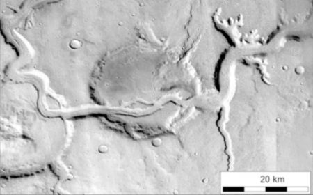
Once however catastrophic events took place, gigantic floods flowing down to the east from the planet’s huge volcanoes to carve out Marineris Valles, the solar system’s largest known canyon. As that water rushed eastward it ripped the terrain apart quickly, creating deep side canyons, drainage valleys, and chopped up regions now dubbed as chaos terrain, multiple mesas separated by numerous fissure-like canyons.

Overview of Marineris Valles and landslide

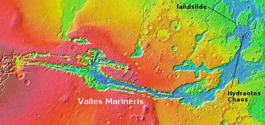
The overview map on the right shows Valles Marineris and its drainage to the east and north into the vast northern plains of Mars. It also shows the location of one of the largest regions on Mars of chaos terrain, dubbed Hydraotes Chaos, located close to the mouth of this gigantic drainage system more than 2,500 miles long.

Massive Martian landslide
Click for full image.

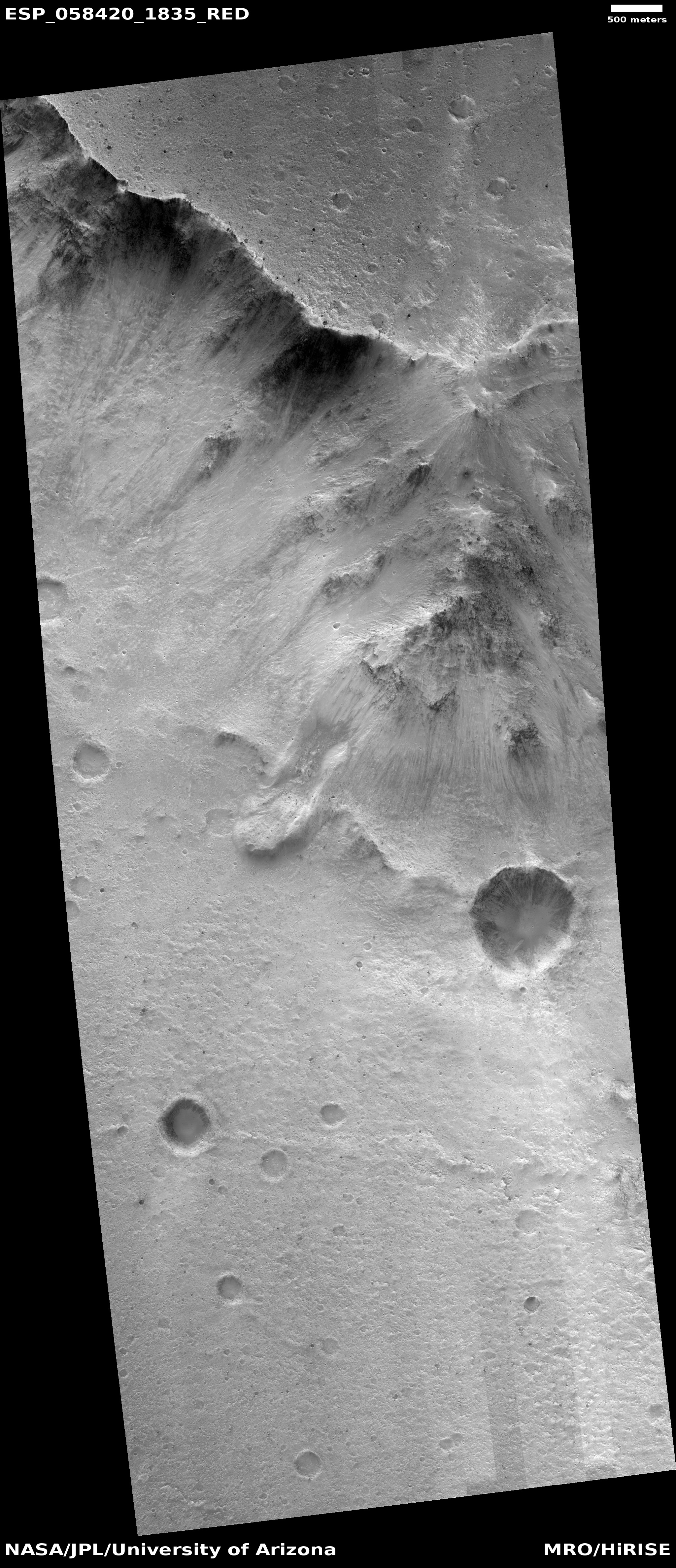
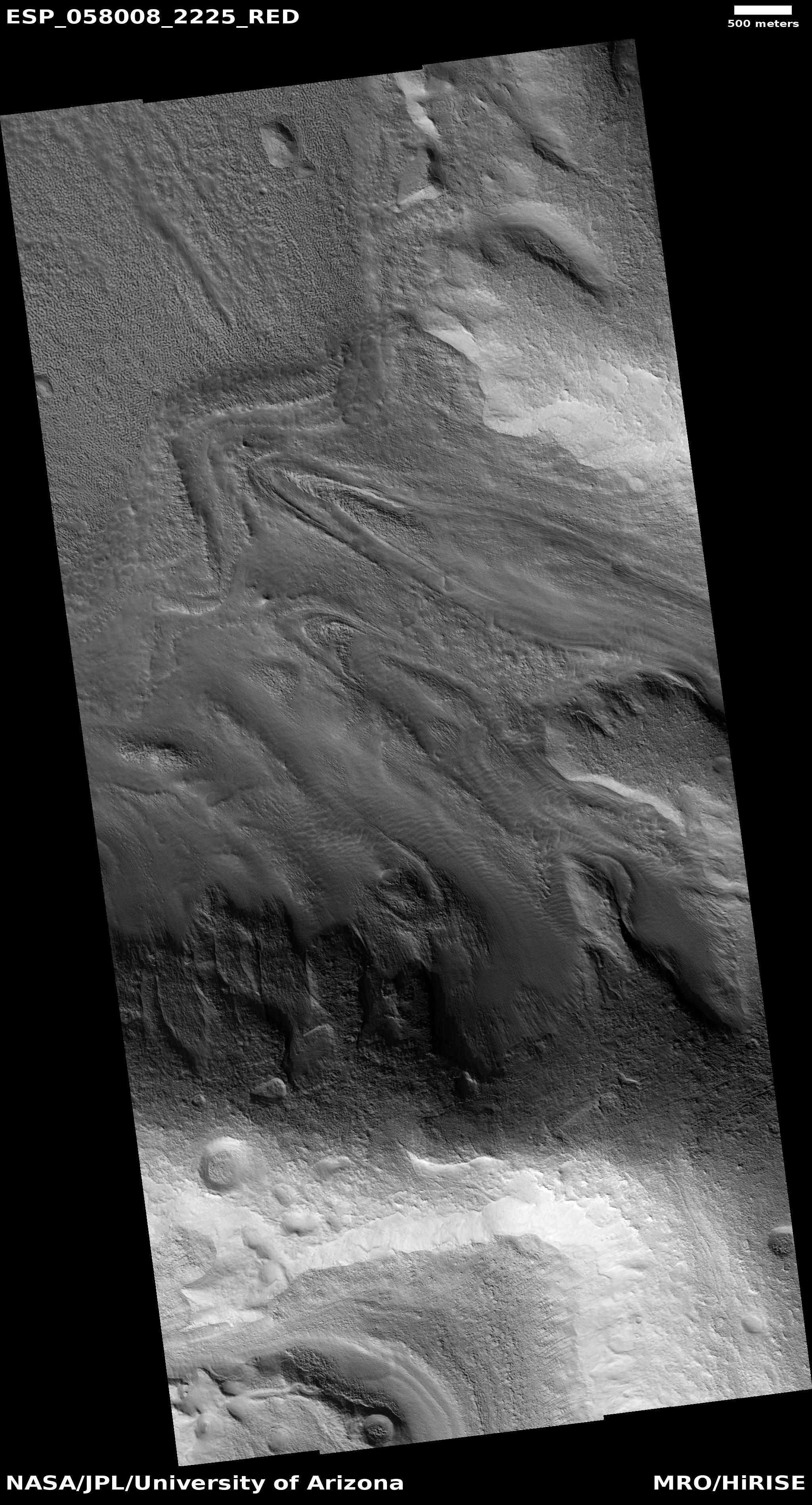
Recently scientists have used the high resolution camera on Mars Reconnaissance Orbiter (MRO) to begin taking images of the massive landslides on the face of the mesa north of Hydraotes Chaos that was hit directly by these floods. The location of the most immediately interesting of these landslide images is also indicated on this overview image.

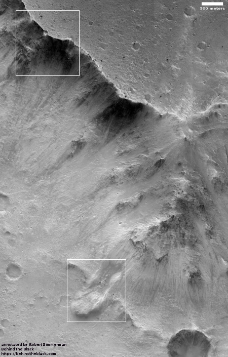
To the right is that image, rotated, cropped, reduced, and annotated to post here. The white boxes indicate two full resolution sections that I highlight below at full resolution.

This image shows that full cliff. The total drop from the plateau at the top to the floor where Hydraotes Chaos is located to the south is approximately 8,200 feet, almost exactly comparable to the depth of the north rim of the Grand Canyon.

The image shows numerous evidence of avalanches and erosion, both at its base and at its rim. None of these avalanches likely occurred during those catastrophic floods, but long afterward.
» Read more

0 comments

InSight hits a rock

Engineers have called a pause in InSight’s drilling operation to insert a heat sensor as much as 16 feet into the Martian soil because it appears the drill has hit a large obstruction.

It penetrated to a depth between 18cm and 50cm into the Martian soil with 4,000 hammer blows over a period of four hours, explained Tilman Spohn, HP3’s principal investigator from the German space agency (DLR). “On its way into the depths, the mole seems to have hit a stone, tilted about 15 degrees and pushed it aside or passed it,” he added. “The mole then worked its way up against another stone at an advanced depth until the planned four-hour operating time of the first sequence expired.”

Prof Spohn said there would now be a break in operations of two weeks while the situation was assessed.

When these facts were first reported on March 1st, the press release did not make it clear at that time that the hammer drill was actually blocked. If it cannot drill down further, this will put a crimp in the heat sensor’s ability to measure Mars’s internal temperature. Right now it is only about a foot down, which on Earth would still have it influenced by surface temperatures.

1 comment

Brain Terrain on Mars

Brain terrain on Mars
Click for full image.

Cool image time! This week the Mars Reconnaissance Orbiter (MRO) science team featured four new captioned images taken by the spacecraft and released as part of the March image dump. The first, dubbed “The Slow Charm of Brain Terrain,” deserves an immediate post on Behind the Black. To the right is only a small section cropped from the full image. From the caption:

You are staring at one of the unsolved mysteries on Mars. This surface texture of interconnected ridges and troughs, referred to as โ€œbrain terrainโ€ is found throughout the mid-latitude regions of Mars. (This image is in Protonilus Mensae.)

This bizarrely textured terrain may be directly related to the water-ice that lies beneath the surface. One hypothesis is that when the buried water-ice sublimates (changes from a solid to a gas), it forms the troughs in the ice. The formation of these features might be an active process that is slowly occurring since HiRISE [MRO’s high resolution camera] has yet to detect significant changes in these terrains.

Below is a cropped section of the full image, rotated and reduced to post here.
» Read more

1 comment

New project to map shallow water sources on Mars

Scientists at the Planetary Science Institute (PSI) in Arizona have begun a new project to map the near-surface ice deposits in the low elevation regions of the Martian northern hemisphere.

Two teams led by Putzig and Morgan were contracted by NASA to pursue separate mapping efforts of subsurface ice deposits in Arcadia Planitia. After their mid-term reports showed significant synergy, the teams were combined in a joint project called โ€œSubsurface Water Ice Mapping (SWIM) on Mars,โ€ which extends the coverage of the mapping project from an experimental swath over Arcadia Planitia to all other low elevation regions across the Martian Northern Hemisphere. โ€œWater ice will be a critical resource for human explorers on Mars, not only for life support but also for generating fuel to power equipment on the ground and rockets for the return journey to Earth,โ€ said Putzig, a Senior Scientist at PSI. โ€œMaps that identify the nature and availability of potential water resources will help determine where humanity will establish its first outposts on Mars.โ€

The SWIM team is producing new maps of the likelihood of subsurface ice deposits over these regions by combining radar, thermal, neutron, altimetry, and image data from several Mars-orbiting spacecraft. The team is also employing newly developed techniques that include using radar returns to infer the presence of ice within the top 5 meters of the crust and applying advanced radar processing to improve resolution at depth and to estimate the purity of ice in the subsurface.

Unlike most planetary research, this project is not aimed specifically at understanding the geology of Mars. Instead, it appears focused on the needs of future human exploration and settlement, finding easily accessible water sources in the northern hemisphere of Mars. The spots they identify will likely be the first Martian real estate of significant value.

1 comment

InSight’s heat sensor begins drilling down

The German-made heat sensor hammer that the U.S. lander InSight placed on the Martian surface has begun hammering its heat sensor into the ground.

On 28 February 2019, the German Aerospace Center (Deutsches Zentrum fรผr Luft- und Raumfahrt; DLR) โ€˜Moleโ€™ fully automatically hammered its way into the Martian subsurface for the first time. In a first step, it penetrated to a depth between 18 and 50 centimetres [7 to 19 inches] into the Martian soil with 4000 hammer blows over a period of four hours. “On its way into the depths, the mole seems to have hit a stone, tilted about 15 degrees and pushed it aside or passed it,” reports Tilman Spohn, Principal Investigator of the HP3 experiment. “The Mole then worked its way up against another stone at an advanced depth until the planned four-hour operating time of the first sequence expired. Tests on Earth showed that the rod-shaped penetrometer is able to push smaller stones to the side, which is very time-consuming.

They will let the hammer cool down for a few days, and then resume hammering. If all goes well, they hope to get as much as 16 feet down.

0 comments

Curiosity sends its first images in two weeks

The computer problems that caused Curiosity to cease science operations two weeks ago appears to have ended with the arrival of the first new images today.

The second link above goes to the images arriving today from Curiosity’s ChemCam camera, designed to take macro images of small features on the surface. The rover also sent down a small set of thumbnail images taken by one of its navigation cameras.

It appears they have figured out why the computer did an unexpected reboot in mid-February, and are now willing to let the rover resume science operations. There is no word on what they have learned, or whether it poses a future threat to the mission, but the fact that they are downloading new data is a good sign.

I must note again that this is news you will not see anywhere else. Most news sources today will wait for the NASA press release to report on Curiosity’s recovery, while I like to do some real journalism, reporting events as they happen. Consider this another reason to donate to Behind the Black during this month’s fund-raising drive.

0 comments
1 141 142 143 144 145 212