Steve McIntyre, the man who had demonstrated that Michael Mann’s hockey stick graph was a fraud, has now demonstrated that the work of a group of climate scientists attempting to resurrect it is even more fraudulent. It seems that in order to recreate the illusion of warming in the past four hundred years, the scientists, led by geologist Shaun Marcott, changed the dates on a series of ocean cores in order to get the results they wanted.
McIntyre found that Marcott and his colleagues used previously published ocean core data, but have altered the dates represented by the cores, in some cases by as much as 1,000 years.
Most significantly, the scientists made no explanation for changing these dates. It is as if they wanted to hide this decline, y’know?
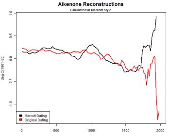
The chart on the right, by McIntyre, illustrates the fraud. The black line shows the temperature numbers of the ocean cores used by Marcott. The red line shows the temperature numbers, as originally published in the scientific literature, for these ocean cores.
The discrepancy here is so egregious that it screams at you. More important, as John Hinderaker says,
» Read more