Deciphering the strange geology of Mars — or anything!

Eroding Medusae Fossae Formation ash deposits
Click for full image.

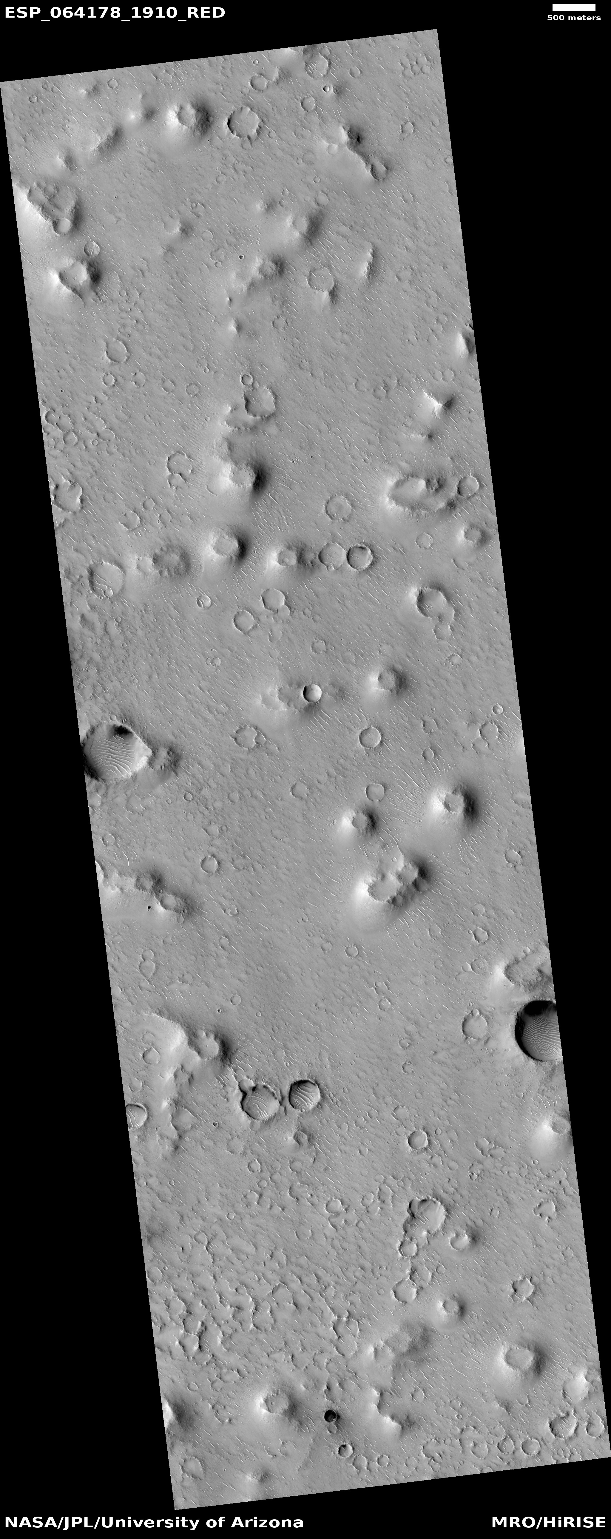
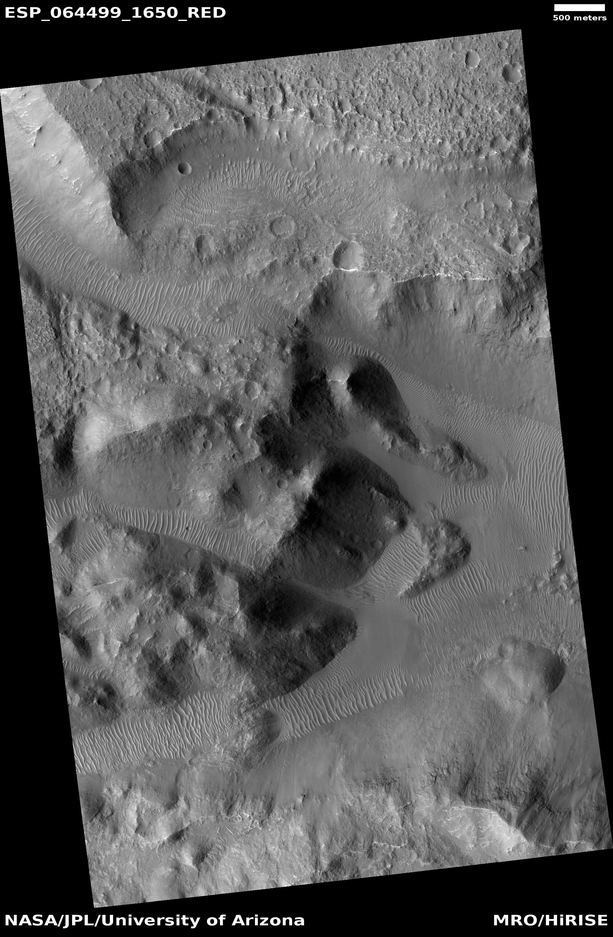
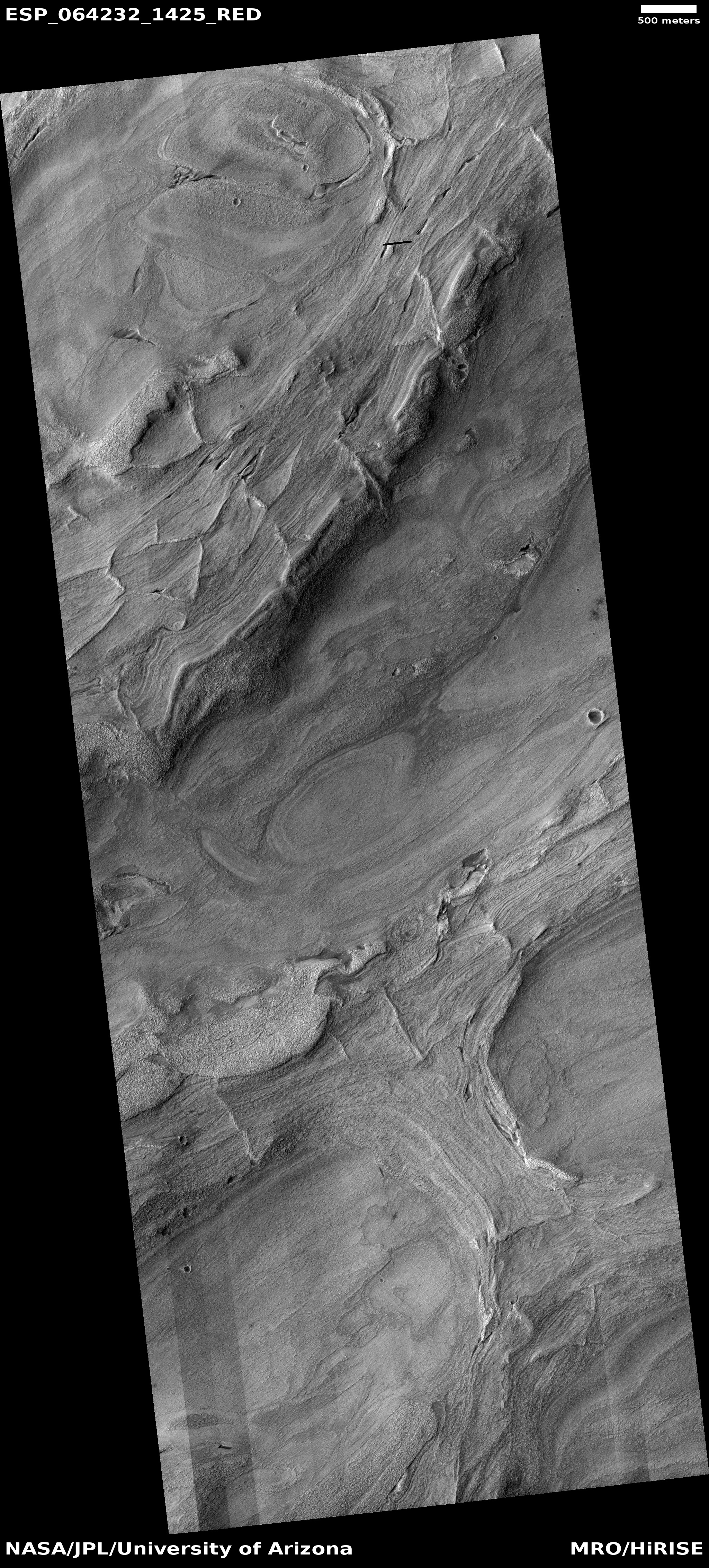
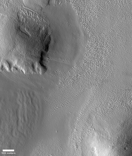
Today’s cool image is for once not taken by the high resolution camera on Mars Reconnaissance Orbiter (MRO). Instead, the image to the right, cropped and reduced to post here, was taken by Mars Odyssey on April 5, 2020, and shows the scouring and erosion caused by winds over many eons in a region dubbed Zephyria Planum. (Note that the image might fool your eye. Sunlight is coming from the east, and the rough terrain at the top is higher than the smooth plain at the bottom.)

Years ago, when I first started to rummage through the archives of images from the various Mars orbiters, I would have seen this image and posted it because I was completely baffled by what I saw, and thought that mystery made it worth showing to the public. Since then my incessant probing of research papers as well as asking a lot of questions of scientists has taught me a lot more about what scientists now surmise of the Martian geology. This greater knowledge in turn makes it possible for me to look at an image like this and immediately make a reasonable guess as to an explanation. This photo, while still containing much that is mysterious, is no longer completely baffling to me.

This willingness to ask questions and dig deeper is fundamental to all things. To have a deeper understanding and not simply guess about any subject, you always have to recognize that your assumptions are likely wrong, and that to learn anything you have to repeatedly ask what I call “the next question.” The first answer will force you to recognize that your first guesses are wrong, raise more questions, which in turn will lead to more questions, and then more questions, and so forth.

Whether I am researching Mars or early space history or politics, this rule always applies. Don’t leap to a conclusion. Think it possible you could be wrong. Ask the next question. And the next. You will repeatedly find that what you thought you knew was not correct, and in the end you will gain a deeper understanding of what is actually known about any subject, as well as what is unknown. And knowing the unknowns is probably the most important thing you can learn.

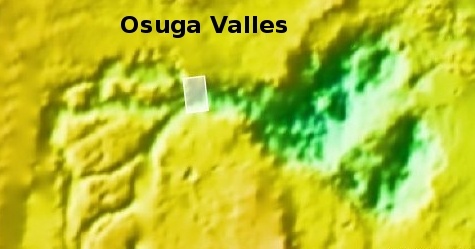
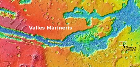
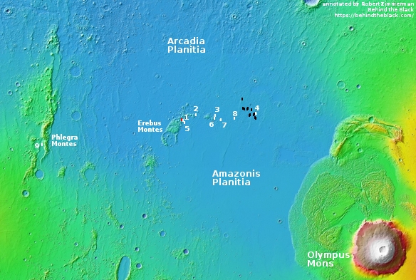
To gain a better understanding of today’s particular image, our first questions must start with context. Where is this feature on Mars? What is the surrounding history of that location? And what is already known about this place?

The location immediately reveals a great deal, as shown in the overview map below.
» Read more

4 comments

Help scientists plan Curiosity’s future travels

The Curiosity science team is asking the help of ordinary citizens in improving the software it uses to plan Curiosity’s future travels.

Using the online tool AI4Mars to label terrain features in pictures downloaded from the Red Planet, you can train an artificial intelligence algorithm to automatically read the landscape.

Is that a big rock to the left? Could it be sand? Or maybe it’s nice, flat bedrock. AI4Mars, which is hosted on the citizen science website Zooniverse, lets you draw boundaries around terrain and choose one of four labels. Those labels are key to sharpening the Martian terrain-classification algorithm called SPOC (Soil Property and Object Classification).

The goal is not to have citizens plan the rover’s route, but to use their judgments to refine the software that the scientists and engineers use to plan the route. This refinement will also be applicable to Perseverance when it gets to Jezero Crater in February 2021.

0 comments

Isidis Basin, on whose margin Perseverance will roam

Pedestal craters in Isidis Basin
Click for full image.

Overview map

Today’s cool image to the right, cropped and reduced to post here, highlights the floor of one of Mars’ largest basins, dubbed Isidis Planitia, and located at the transition zone between the planet’s northern lowland plains and the southern cratered highlands.

The overview map below of Isidis Basin provides some context. The white box shows where this particular image is located. Jezero Crater, indicated by the red circle (which is also about the size of the crater), is where the rover Perseverance is going to land and roam come February 2021, should all go well. For scale, Isidis is about the size of the eastern half of the United States. If Chicago was located at Jezero Crater, Baltimore would be on the basin’s eastern edge, at around 4 o’clock.

This particular section of the full photo, taken on April 5, 2020 by the high resolution camera on Mars Reconnaissance Orbiter (MRO), shows many features very typical of the floor of Isidis Basin, which also immediately reveal a great deal about its possible history.

In this small snippet we can see what at first glance appear to be pedestal craters standing up like mesas, with ordinary craters scattered about on that lower surrounding terrain. Clearly, if these are pedestal craters they had to have been created first, and then over a very long time erosion processes ate away at that plain, leaving these pedestals (which had become resistant to erosion because the impact had packed their material together and made it harder) behind as mesas.

Then, after this period of erosion was complete enough additional time was required for at least one or two rounds of cratering to occur, leaving behind the many more younger craters on the plain floor, many of which are now partly buried by dust and sand.

The problem is that these mesas are almost certainly not pedestal craters, despite their appearance. » Read more

3 comments

Fading Martian slope streaks

Fading Martian slope streaks
Click for full image.

Cool image time! I’ve covered the topic of the mysterious slope streaks on Mars previously in great detail (see here and here). Essentially they are generally dark streaks (but sometimes light) that appear randomly on slopes and then fade over time. Unlike recurring slope lineae, another changing streak found on Martian slopes, the coming and going of slope streaks is not tied to the seasons. They can appear at any time in the year, and will take several Martian years to fade away.

The image to the right, rotated, cropped, and reduced to post here, was taken by the high resolution camera on Mars Reconnaissance Orbiter (MRO) on March 26, 2020. It shows numerous slope streaks down the eastern interior rim of a crater in the transition zone between the northern lowlands and the southern cratered highlands in a region dubbed Arabia Terra.

Though I can find no previous high resolution image of this crater to measure any temporal changes, you can clearly see that this slope has experienced many streaks over time, with some darker than others. The different shades suggest that the lighter streaks are older and have faded, with the darker streaks more recent events.

At the moment there is no strong consensus on the causes of these streaks. As one science paper noted, “The processes that form slope streaks remain obscure. No proposed mechanism readily accounts for all of their observed characteristics and peculiarities.” We know they occur in equatorial regions and dusty locations, and that they are triggered by some disturbance at the topmost point of the streak, which then causes a chain reaction down the slope. Other than that, the facts are puzzling, and suggest that these streaks are a phenomenon wholly unique to Mars.

The crater itself, located at 24 degrees north latitude, has some other mysteries. The features on its floor, for instance, are very puzzling. Though suggestive of the buried glaciers found in many craters in the mid-latitudes, this crater is a bit too far south. Maybe its higher altitude allows for some ice to remain here? Then again, the features on that floor might have nothing to do with ice. Maybe we are looking at sand carved by wind? Or hardened mud that was once wet?

I am merely guessing, a dangerous thing to do when one’s knowledge is limited. Then again, it’s fun, so please join in with your own guesses.

11 comments

OSIRIS-REx spots sun-caused erosion on Bennu

Rock on Bennu showing exfoliation
Click for full figure.

An analysis of images taken by OSIRIS-REx of the asteroid Bennu has allowed scientists to identify places where the changing temperatures from day to night has caused the surfaces of rocks to flake away, a process geologists label exfoliation.

The image on the right, cropped and reduced to post here, is from figure 1 in the paper. The yellow arrow points to a typical example of exfoliation, which is a process you can see on many rocks here on Earth.

Rocks expand when sunlight heats them during the day and contract as they cool down at night, causing stress that forms cracks that grow slowly over time. Scientists have thought for a while that thermal fracturing could be an important weathering process on airless objects like asteroids because many experience extreme temperature differences between day and night, compounding the stress. For example, daytime highs on Bennu can reach almost 127 degrees Celsius or about 260 degrees Fahrenheit, and nighttime lows plummet to about minus 73 degrees Celsius or nearly minus 100 degrees Fahrenheit. However, many of the telltale features of thermal fracturing are small, and before OSIRIS-REx got close to Bennu, the high-resolution imagery required to confirm thermal fracturing on asteroids didn’t exist.

The mission team found features consistent with thermal fracturing using the spacecraft’s OSIRIS-REx Camera Suite (OCAMS), which can see features on Bennu smaller than one centimeter (almost 0.4 inches). It found evidence of exfoliation, where thermal fracturing likely caused small, thin layers (1 – 10 centimeters) to flake off of boulder surfaces. The spacecraft also produced images of cracks running through boulders in a north-south direction, along the line of stress that would be produced by thermal fracturing on Bennu.

The typical erosion processes that can cause exfoliation (weather, gravity) are not possible on tiny Bennu, so the solution appears to rest with sunlight and sunlight alone.

This is not really a surprising result, but it is the first time it has been documented by data.

1 comment

A global map of rockfalls on the Moon

A global map of the rockfalls found on the Moon
Click for full resolution image.

A review of more than two million Lunar Reconnaissance Orbiter (LRO) images of the Moon has allowed scientists to compile the first global map of lunar rockfalls.

The map on the right comes from the paper. From the press release:

The result is a map of the lunar surface between 80 degrees northern and southern latitude that shows 136,610 rockfalls with diameters of more than two and a half meters. “For the first time, this map enables us to systematically analyze the occurrence and causes of rockfalls on another celestial body”, says Dr. Urs Mall from MPS.

Previously, scientists had assumed that lunar quakes in particular were responsible for the displacement of boulders. The new global map of rockfalls indicates that impacts from asteroids may play a much more important role. They are apparently – directly or indirectly – responsible for more than 80 percent of all observed rockfalls.

“Most of the rockfalls are found near crater walls,” says Prof. Dr. Simon Loew of ETH Zurich. Some of the boulders are displaced soon after the impact, others much later. The researchers hypothesize that impacts cause a network of cracks that extend in the underlying bedrock. Parts of the surface can thus become unstable even after very long periods of time.

Though the map suggests vaguely that these rockfalls are more scattered on the lunar farside and more concentrated in the mid-latitudes on the nearside, I suspect this is likely not so. If it is however it reveals something about the Moon that needs to be explained.

0 comments

Bennu’s forbidding gravelly surface

Gravelly Osprey landing site on Bennu
Click for a higher resolution version.

On May 26 the OSIRIS-REx science team completed their first rehearsal and close approach to their back-up sample-grab-and-go site on Bennu, dubbed Osprey, getting as close as 820 feet. The image to the right, cropped and reduced to post here, shows that sample site within the white box. According to the image caption, the “long, light-colored boulder to the left of the dark patch, named Strix Saxum, is 17 ft (5.2 m) in length.” Note also that they have rotated the image so that east is at the top in order to make it more easily viewed.

This particular spot in this crater is actually a revision from their first choice from early in 2019, which originally was to the right and below the dark patch in the center of the crater. After six months of study, they decided instead on the present target area above the dark patch, because it seemed safer with the most sampleable material.

So how safe is this new location? Let’s take a closer look.
» Read more

9 comments

An exposed dry waterfall on Mars

An exposed dry waterfall on Mars
Click for full image.

Close overview map

Wide overview map

Cool image time! The photo to the right, cropped and reduced to post here, was taken on April 30, 2020 by the high resolution camera on Mars Reconnaissance Orbiter (MRO). Uncaptioned, the science team titled the release as a “Cataract in Osuga Valles.”

To understand what we are looking at it is necessary to also see a wider view, as provided by the context map below and to the right. As you can see, this image straddles across the canyon called Osuga Valles, and heads downstream to the east. It also shows a point where the grade of that canyon suddenly drops. If water ever flowed here this place would have been the location of a truly spectacular waterfall.

More likely, these cataracts mark the location where sometime in the past a glacier had flowed down this valley, cutting a path until it broke out into the large and wide dead end area that appears to have no clear outlet. For some reason at this point the downhill grade of this canyon suddenly dropped, with the glacier following that sudden steep drop.

There is no glaciers here now, as this location is at 14 degrees south latitude, too close to the equator for any ice to remain close to the surface. Instead, dust dunes remain as the only feature flowing down through these cataracts.

The second overview map provides further context, showing the location of Osuga Valles relative to nearby Valles Marineris, the largest known canyon system in the solar system. Whatever process formed that gigantic canyon system certainly was a factor in forming Osuga Valles. The details however are not yet understood with any certainty. All we presently have are theories.

1 comment

InSight mole team reports some digging success

InSight scoop pushing against mole as it digs
Click to watch movie.

A new strategy devised in February to use the scoop on the Mars InSight lander to push down on the mole digging tool so that it could gain traction and dig downward has apparently had some success.

We started about seven centimetres above the surface on Sol 458 (11 March) and we are now at the surface with the scoop on Sol 536 (30 May 30), after six cycles of hammering over 11 weeks.

If you click on the image on the right you can see a movie assembled from images taken since February as they pushed down. The mole has clearly descended into the Martian soil about seven centimeters, or about three inches. The issue now, as shown in the movie, is that the mole is now deep enough that the scoop is pressed against the ground. It can’t really push down anymore on the mole, at least in this configuration.

They have the option of using the scoop’s tip to push farther into the ground, but that involves some risk. First they plan to let the mole continue to dig, without the scoop’s help, in the hope that it is now finally deep enough into the ground that the ground is finally able to provide the friction required to hold the mole in place. If this doesn’t work, they will then try using the scoop to fill the hole up to provide more friction.

If that doesn’t work, they will then try using the scoop tip to provide the added pressure.

All in all, it does appear there is now hope that the mole will eventually get the heat sensor for measuring the internal temperatue on Mars deep enough to do its primary mission. Stay tuned!

3 comments

The strange squashed ridges at the basement of Mars

Squashed ridges at the basement of Mars
Click for full image.

Overview map

Cool image time! The photo on the right, cropped and reduced to post here, was taken by the high resolution camera on Mars Reconnaissance Orbiter (MRO) on April 9, 2020, and shows the very weird and very packed ridges and layers that are found routinely at the deepest part of Hellas Basin, what I have dubbed the basement of Mars.

Be sure to click on the image to see the full photograph. There’s lots more strangeness to see there. And be sure to read my post in the second link, which highlights a similarly strange set of packed ridges, and where I note:

This is the basement of Mars, what could be called its own Death Valley. The difference however is that unlike Death Valley, conditions here could be more amendable to life, as the lower elevation means the atmosphere is thicker.

The context map to the right shows Hellas, with the location of today’s image indicated by the white box, close to basin’s lowest point, more than five miles below the basin’s rim. Overall the Hellas Basin is about the size of the western United States, from the Mississippi River to the Pacific Ocean. It is believed that the entire basin was created by a single gigantic impact that occurred about four billion years ago when the solar system’s inner planets were undergoing what has been labeled the Late Heavy Bombardment.

The specific process that formed these ridges, dubbed honeycomb terrain by scientists, remains unknown however. There are of course theories, none of which are very convincing. Here’s mine, as outlined in the previous post:
» Read more

4 comments

Thar’s ice in them Martian hills!

Icy mountains in Erebus Montes?
Click for full image.

Overview map of Starship landing site images

Cool image time! Today we return to the Erebus Mountains, located just to the west of SpaceX’s prime candidate landing site for Starship on Mars. The photo to the right, taken on April 4, 2020 by the high resolution camera on Mars Reconnaissance Orbiter (MRO) and rotated, cropped, and reduced to post here, shows one particular area between the peaks in those mountains, and also happens to be very close to what I have labeled image #1 in SpaceX’s Starship landing site photos.

The second image below and to the right shows an overview map of this region, with the SpaceX photos indicated by the numbered white boxes and the location of this image indicated by the red box, right next to image #1. The black boxes were images that SpaceX had obtained from MRO earlier, when it was first planning to send a Dragon capsule to Mars using a Falcon Heavy, a project the company has put aside in its focus on building Starship.

To my eye, everything in the first image above reeks of an icy, glacial terrain. I certainly am guessing, but it is an educated guess based on looking at numerous similar images in this region (see here and here, ) as well as in the nearby Phlegra mountains to the west. I also base my guess on what I have learned interviewing planetary scientists who are studying these images. The reasonableness of this guess is further strengthened in that the location is at 39 degrees north latitude, dead center in the mid-latitude bands where scientists have found evidence of numerous buried glaciers.

If Starship lands just to the east of the Erebus Mountains, the first colonists will likely not only have water available at their feet close to the surface in the flat lowland plains, if they find that resource insufficient they will need only climb uphill a bit into these hills to dig out as much ice as they could ever need.

0 comments
1 111 112 113 114 115 157