Scientists better constrain time frame of Mars’ active dynamo

Using data from the MAVEN orbiter, scientists have now constrained the time frame when Mars’ dynamo was active and producing a global magnetic field, between 3.7 and 4.5 billion years ago.

Magnetism in certain rocks on Mars’ surface indicate that the Martian dynamo was active between 4.3 and 4.2 billion years ago, but the absence of magnetism over three large basins – Hellas, Argyre, and Isidis – that formed 3.9 billion years ago has led most scientists to believe the dynamo was inactive by that time.

Mittelholz’s team analyzed new data from NASA’s Mars Atmosphere and Volatile Evolution (MAVEN) orbiter and found clear evidence of a magnetic field coming from the Lucus Planum lava flow that formed about 3.7 billion years ago – much later than at other areas studied.

There is of course a lot of uncertainty here.

0 comments

Europa’s mysterious stained grooves

Europa's jumbled icepack
Click for full image.

From 1995 to 2003 the Galileo orbiter circled Jupiter 34 times. During those orbits the spacecraft made numerous close fly-bys of Jupiter’s moons, including eleven past the tantalizingly mysterious moon Europa.

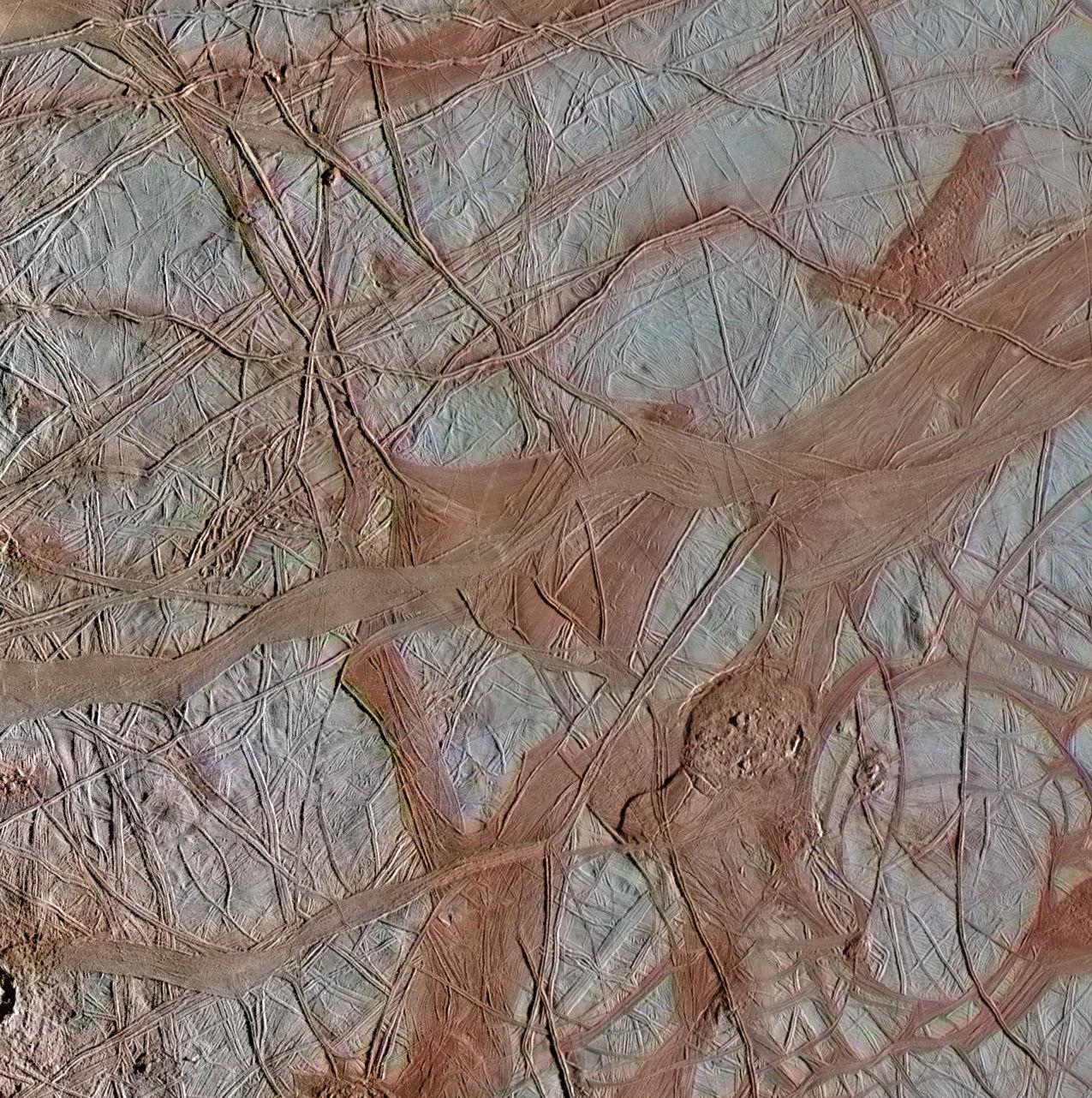
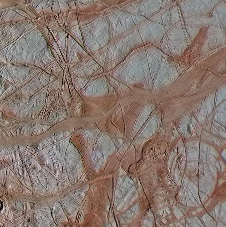
The image to the right was taken during the eighth fly-by of Europa. It is one of three Galileo images of Europa that scientists have pulled from the Galileo archive and subjected to modern computer processing in order to improve what can be seen. The other two can be found here and here. From the release for the image to the right:

All three images were captured along the same longitude of Europa as Galileo flew by on Sept. 26, 1998, in the spacecraft’s 17th orbit of Jupiter (orbit E17). It was the eighth of Galileo’s 11 targeted flybys of Europa. High-resolution images were taken through a clear filter in grayscale (black and white). Using lower-resolution, color images of the same region from a different flyby (orbit E14), technicians recently mapped color onto the higher-resolution images.

In other words, they laid the colors from a lower resolution color image on top of the high resolution black & white image so that we could see these three images in color. The blue and white areas are made of up water ice, while the reddish areas are made up of “more non-ice materials.”

The vagueness for describing the non-ice materials is intentional, as scientists still do not know what they made of. They do believe that this material came from the planet’s interior, as the red material is always found aligned with the cracks, fissures, and grooves, as illustrated clear by this image.

What has always struck me about this surface of Europa since I first saw similar Galileo images back in 1998 and wrote about them for the magazine The Sciences is how much it resembles the Arctic ice pack as seen by early explorers during their attempts to reach the North Pole, jumbled jigsaw pieces of ice packed together but moving slowly so that the cracks between them shift and change over time.

The resemblance adds weight to the theory that there is a liquid ocean below Europa’s icepack, and the red material hints at some intriguing chemistry coming from that ocean.

5 comments

A Martian lava flood plain

A Martian lava flood plain?
Click for full image.

Cool image time! The photo to the right, cropped to post here, was taken by the high resolution camera on Mars Reconnaissance Orbiter (MRO) on March 2, 2020, and shows some inexplicable shallow pits and depressions in the middle of a relatively flat and featureless plain.

Make sure you click on the image to see the full photo. Though the plain looks remarkably smooth, a handful of dark splotches are scattered about, almost all of which occur on top of small craters.

What causes these depressions? The MRO team calls this “Landforms near Cerberus Tholi.” Cereberus Tholi is a a collection of several indistinct and relatively small humps that scientists think might be shield volcanoes.

More clues come from the overall context.
» Read more

1 comment

The first complete geologic map of Moon

Geologic map of Moon

Using data from several recent lunar orbiters, scientists have compiled and now released the first comprehensive geologic map of the Moon.

To create the new digital map, scientists used information from six Apollo-era regional maps along with updated information from recent satellite missions to the moon. The existing historical maps were redrawn to align them with the modern data sets, thus preserving previous observations and interpretations. Along with merging new and old data, USGS researchers also developed a unified description of the stratigraphy, or rock layers, of the moon. This resolved issues from previous maps where rock names, descriptions and ages were sometimes inconsistent.

“This map is a culmination of a decades-long project,” said Corey Fortezzo, USGS geologist and lead author. “It provides vital information for new scientific studies by connecting the exploration of specific sites on the moon with the rest of the lunar surface.”

The image to the right shows the Moon’s near side.

The complete map file is free to download, and I guarantee that scientists and engineers in China are downloading it even as I type, planning to use it to establish their ownership to the Moon’s most valuable real estate that we scouted for them.

4 comments

Stucco on Mars

Stucco on Mars
Click for full image.

As a break from Wuhan flu madness I give you another cool image, cropped and reduced to post here, taken by the high resolution camera on Mars Reconnaissance Orbiter (MRO). I call this stucco on Mars because that is exactly what it looks like. It is as someone laid down a layer of damp concrete and then ran over it roughly with a trowel to raise the knobs scattered across the surface.

The uncaptioned MRO image calls this “Aligned Mounds with Broad Summit Pits”. Those aligned mounds run across the top of the image. I suspect they are pedestal craters, left over because the impact had packed and hardened the crater so that it resisted erosion as the surrounding terrain was worn away.

The two insets, posted below at full resolutoin, focus on one of those pedestal craters as well as the distinct mesa at the bottom of the photo.
» Read more

0 comments

Rock droplets hitting a Martian plain

Depressions in Amazonis Planitia
Click for full image.

Cool image time! The photo the right, rotated, cropped, and reduced to post here, is not only cool, it contains a punchline. It was taken by the high resolution camera on Mars Reconnaissance Orbiter (MRO) on February 11, 2020 and shows one small area between two regions in the northern lowlands of Mars, dubbed Amazonia Planitia (to the south) and Arcadia Planitia (to the north) respectively.

This region is thought to have a lot of water ice just below the surface., so much in fact that Donna Viola of the University of Arizona has said, “I think you could dig anywhere to get your water ice.”

I think this image illustrates this fact nicely. Assuming the numerous depressions seen here were caused by impacts, either primary or secondary, it appears that when they hit the ground the heat of that impact was able to immediately melt a wide circular area. My guess is that an underwater ice table immediately turned to gas so that the dusty material mantling the surface then sagged, creating these wider circular depressions.

Of course, this is merely an off-the-cuff theory, and not to be taken too seriously. Other processes having nothing to do with impacts could explain what we see. For example, vents at the center of these craters might have allowed the underground ice to sublimate away, thus allowing the surface to sag.

So what’s the punchline?
» Read more

1 comment

Interstellar Comet 2I/Borisov has an excess of carbon monoxide

Astronomers using two difference space telescopes have found that Comet 2I/Borisov, the first known interstellar comet, has an abundance of carbon monoxide when compared to solar system comets.

The team used Hubble’s unique ultraviolet sensitivity to spectroscopically detect carbon monoxide gas escaping from comet Borisov’s solid comet nucleus. Hubble’s Cosmic Origins Spectrograph observed the comet on four separate occasions, from Dec. 11, 2019 to Jan. 13, 2020, which allowed the researchers to see the object’s chemical composition change quickly, as different ice mixtures, including carbon monoxide, oxygen, and water, sublimated under the warmth of the Sun.

The Hubble astronomers were surprised to find that the interstellar comet’s coma, the gas cloud surrounding the nucleus, contains a high amount of carbon monoxide gas, at least 50% more abundant than water vapor. This amount is more than three times higher than the previously measured quantity for any comet entering the inner solar system. The water measurement was made by NASA’s Neil Gehrels-Swift satellite, whose observations were conducted in tandem with the Hubble study.

Carbon monoxide ice is very volatile. It doesn’t take much sunlight to heat the ice and convert it to gas that escapes from a comet’s nucleus. For carbon monoxide, this activity occurs very far from the Sun, about 11 billion miles away, more than twice the distance of Pluto at its farthest point from the Sun. In contrast, water remains in its icy form until about 200 million miles from the Sun, the approximate distance of the inner edge of the asteroid belt.

However, for comet Borisov, the Hubble measurements suggest that some carbon monoxide ice was locked inside the comet’s nucleus, revealed only when the Sun’s heat stripped away layers of water ice. “The amount of carbon monoxide did not drop as expected as the comet receded from the Sun. This means that we are seeing the primitive layers of the comet, which really reflect what this object is made of,” Bodewits explained. “Because of the abundance of carbon monoxide ice that survived so close to the Sun, we think that comet Borisov comes from a much colder place and from a very different debris disk around a star than our own.”

With solar system comets, the ratios between water and carbon monoxide are the reverse, with much more water detected. They theorize, based on these results, that the comet might have come from a cool red dwarf star, but with the available data that is nothing more than a guess at this point.

0 comments

Strange terrain in the Martian lowlands

Strange terrain in northern lowlands
Click for full image.

Cool image time! The science team for the high resolution camera on Mars Reconnaissance Orbiter (MRO) yesterday released a new captioned image, entitled “Disrupted Sediments in Acidalia Planitia”, noting that the photo

…shows a pitted, blocky surface, but also more unusually, it has contorted, irregular features.

Although there are impact craters in this area, some of the features … are too irregular to be relic impact craters or river channels. One possibility is that sedimentary layers have been warped from below to create these patterns. The freezing and thawing of subsurface ice is a mechanism that could have caused this.

The image to the right, rotated, cropped, and reduced to post here, shows the lower quarter of the full image. While in some areas it does appear as if changes below the surface caused the surface to warp and collapse, as suggested by the caption, in other places it looks more like the top layers themselves sublimated away without disturbing what was below them.

Note for example the pits near the bottom of the photograph. They clearly show sedimentary layers on their cliff walls, including the tiny circular mesa in the middle of the rightmost pit.

If these pits were collapsing from below, their cliffs would be more disturbed, because it would have been those lower layers that sublimated first. Instead, it appears that the top layer disappeared first, followed by each lower layer, one by one.

This region of strange terrain is located in the middle of the northern lowland plains. The overview map below gives some context, with the small white box showing this photo’s location.
» Read more

0 comments

Rover update: Curiosity heads downhill

Curiosity's last look across the Greenheugh Pedimont
Click for higher resolution.

[For the overall context of Curiosity’s travels, see my March 2016 post, Pinpointing Curiosity’s location in Gale Crater. For the updates in 2018 go here. For a full list of updates before February 8, 2018, go here.]

After finally reaching the top of the Greenheugh Pedimont (see both the March 4 and March 8, 2020 rover updates) and spending more than a month there, drilling one hole, getting samples, and taking a lot of photos, the Curiosity science team in the past week has finally sent the rover retreating back downhill, following the same route it used to climb uphill.

The panorama above was taken on April 10, 2020, and shows the last view looking south across that pedimont towards Mount Sharp, before that descent. As you can see, trying to traverse that terrain would have been very difficult, and probably very damaging to Curiosity’s wheels.
» Read more

0 comments

Movie of OSIRIS-REx touch-and-go rehearsal

Checkpoint rehearsal: last image
Click for movie.

The OSIRIS-REx science team yesterday released a short movie, compiled from thirty images taken during the April 14, 2020 rehearsal of the spacecraft’s planned August touch-and-go sample grab from the asteroid Bennu.

The rehearsal brought the spacecraft through the first two maneuvers of the sampling event to a point approximately 213 feet (65 meters) above the surface, before backing the spacecraft away. These images were recorded over a ten-minute span between the execution of the rehearsal’s “Checkpoint” burn, approximately 394 feet (120 meters) above the surface, and the completion of the back-away burn, which occurred approximately 213 feet (65 meters) above the surface. The spacecraft’s sampling arm – called the Touch-And-Go Sample Acquisition Mechanism (TAGSAM) – is visible in the central part of the frame, and the relatively clear, dark patch of Bennu’s sample site Nightingale is visible in the later images, at the top. The large, dark boulder that the spacecraft approaches during the sequence is 43 feet (13 meters) on its longest axis.

The image to the right is the last frame of the movie, as the spacecraft has begun its retreat. The smoother area of Nightingale is at the top.

Based on the video, it appears as if the spacecraft would have missed the Nightingale target site had the rehearsal continued to touchdown. This might not be so, however. And even if it is, the reason for the rehearsal is to allow engineers to refine the process to make it more accurate. We shall see what changes in the second rehearsal in about a month or so.

0 comments

Baby Martian volcanoes

Cratered cone near Noctis Fossae
Click for full image.

Cool image time! I came across this strange feature shown on the right in my normal rummaging through the archive of the high resolution camera on Mars Reconnaissance Orbiter (MRO). The photo, rotated, cropped, and reduced to post here, focuses on what they label a “cratered cone.”

The immediate thought is that this is a volcano cone, and the craters at its peak are not impact craters but calderas. In science however such a knee-jerk conclusion is always dangerous. For example, this might instead be a pedestal crater, where the surrounding terrain was worn away over eons, leaving the crater sitting high and dry.

It is therefore important to look deeper to determine what origin of this feature might be.

First, its location, as shown in the overview map below, provides us our first clue.
» Read more

1 comment

Confirmed: Comet ATLAS has broken apart

Astronomers have now confirmed the fact that Comet ATLAS has broken into several pieces, and will not put on a spectacular sky show this coming May.

Just a month ago, it looked like the icy wanderer, officially known as C/2019 Y4 Atlas, might put on a dazzling sky show around the time of its closest approach to the sun, or perihelion, which occurs on May 31.

But relatively lackluster behavior soon dimmed such hopes. And optimism surrounding the comet is now pretty much extinguished, for it’s no longer in one piece. Comet Atlas “has shattered both its and our hearts,” astrophysicist Gianluca Masi, the founder and director of the Virtual Telescope Project in Italy, said in an emailed statement on Sunday (April 12). “Its nucleus disintegrated, and last night I could see three, possibly four main fragments.”

A nice picture of the break-up can be seen here.

We are due for another great comet, like Comet Hale-Bopp in the late 1990s. Unfortunately, Comet ATLAS won’t be that comet.

1 comment
1 113 114 115 116 117 157