Sightseeing in the region near the Starship Mars landing zone

Sightseeing in the region near Starship's landing zone
Click for original image.

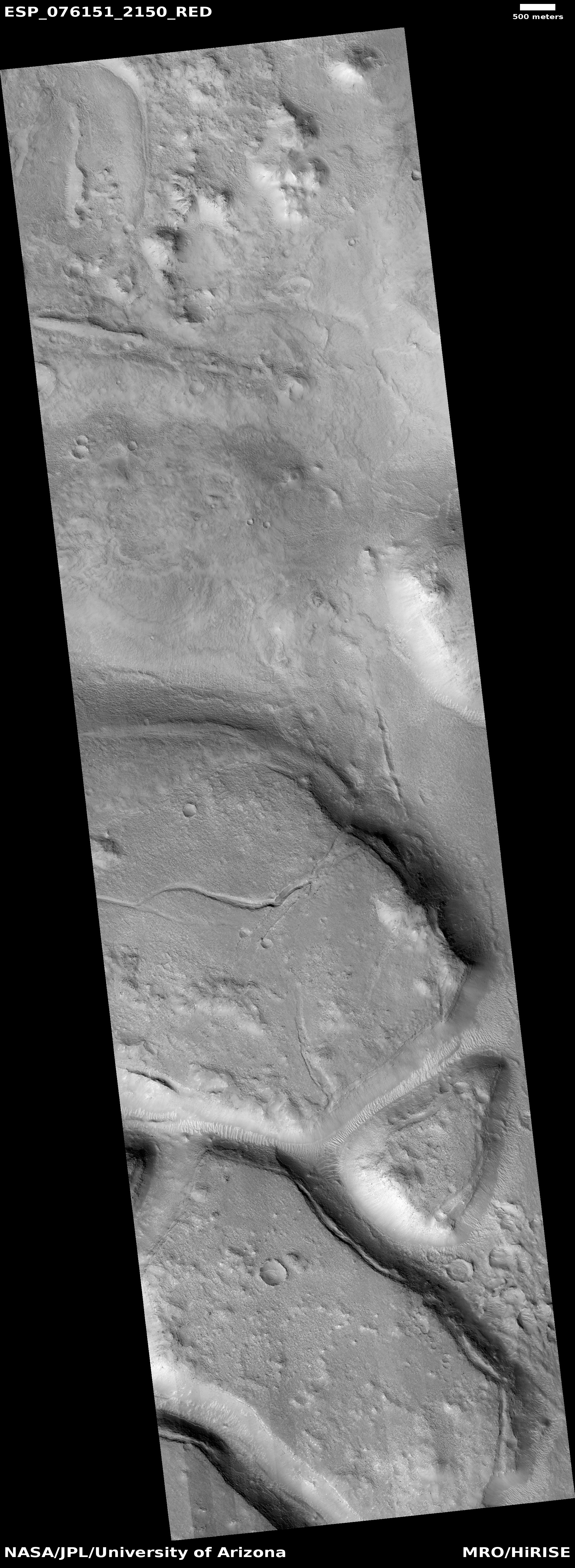
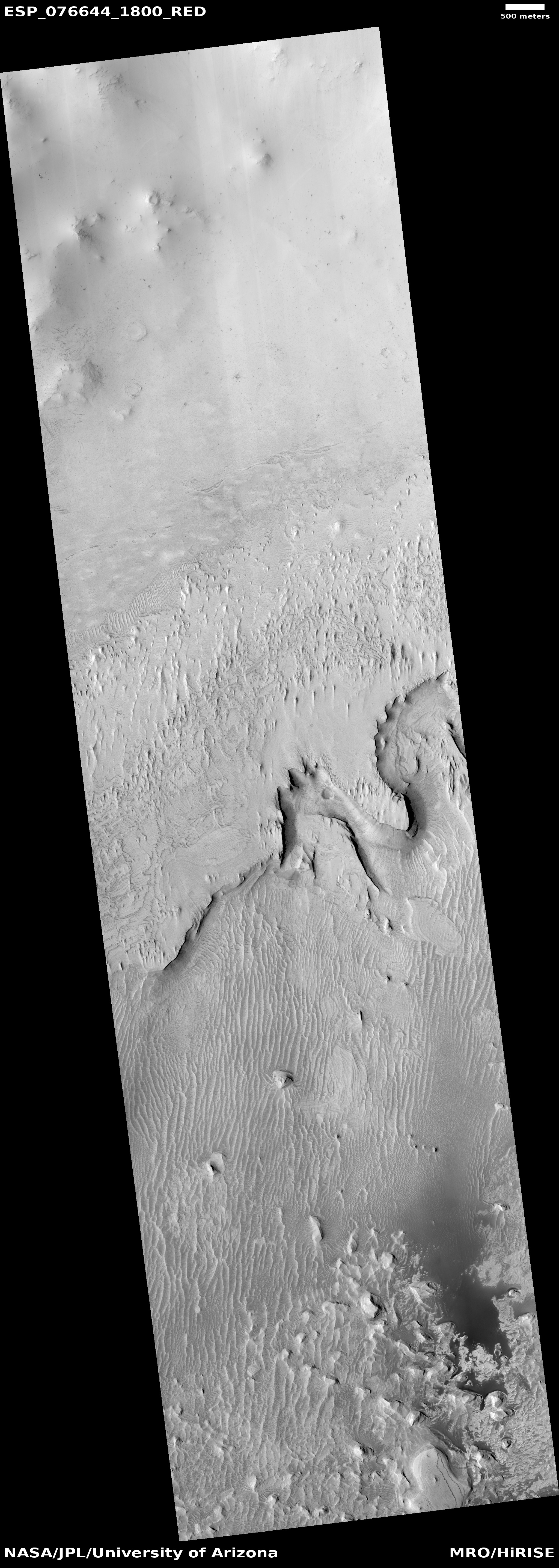
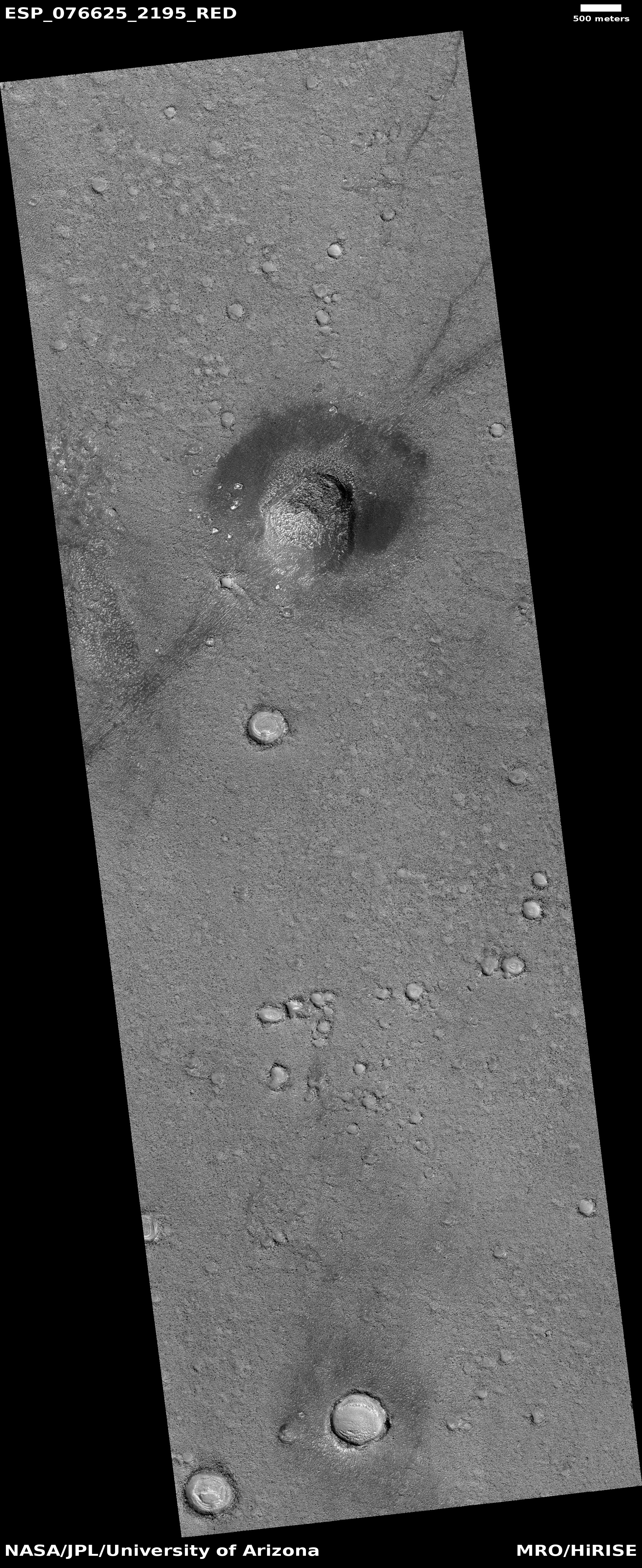
Cool image time! The picture to the right, cropped and reduced to post here, was taken on November 30, 2022 by the high resolution camera on Mars Reconnaissance Orbiter (MRO). It shows a bulbous hill in the icy northern lowland plains of Mars. That it is icy here is indicated by the glacier features that appear to fill the small crater near the bottom of the picture.

You can get a better sense of stark alien nature of this terrain by looking at an MRO context camera image of the same area, taken on April 1, 2008. The subject hill is the first hill on the image’s west side, going from the top. This is a flat plain interspersed with crater splats, mounds of a variety of sizes, and a puzzling meandering dark line that suggests a crack from which material is oozing.

The geology to be studied here might be endless but for tourists the views will be astounding in their alienness.
» Read more

2 comments

A Martian glacier waterfall?

A Martian glacier waterfall?
Click for original image.

Cool image time! The photo to the right, cropped, reduced, and sharpened to post here, was taken on October 25, 2022 by the high resolution camera on Mars Reconnaissance Orbiter (MRO). It shows a small meandering canyon that appears to drain into a larger side canyon, all part of a region of chaos terrain dubbed Galaxias Chaos in the Martian northern mid-latitudes.

Though the latitude is 35 degrees north, where we should see lots of evidence of glacial features, especially because this is chaos terrain — terrain unique to Mars — that generally appears formed by such processes, I find few outright obvious glacial features in this cropped portion or in the full image.
» Read more

2 comments

The barren and icy northern lowland plains of Mars

The barren and icy northern lowland plains of Mars
Click for original image.

Cool image time! The picture to the right, cropped and sharpened to post here, was taken on January 2, 2023 by the high resolution camera on Mars Reconnaissance Orbiter (MRO). Taken to fill a gap in the camera’s planned image schedule in order to maintain its temperature, the location was in this sense picked not for any particular scientific research project, but because the camera team decided they might find something interesting at this spot.

What they found is a vast flat plain of polygons, a feature found frequently on the surface of Mars and thought to be formed from processes similar to the drying that creates similar polygon cracks in dried mud here on Earth. In this case, the cracks are almost certainly in ice. As Colin Dundas of the U.S. Geological Surveyโ€™s Astrogeology Science Center in Arizona explained to me previously,
» Read more

0 comments

A Russian Mars airplane?

According to Russia’s state run press, a team of engineers at the Moscow Aviation Institute (MAI), working in partnership with engineers from India, are developing a fixed-wing robotic airplane for use on Mars.

The work on the Marsoplane began in April 2022 after the funding request was approved by the Russian Science Fund. Karpovich believes that the team of scientists will be able to successfully test the technology demonstrator by the end of next year. “By the end of 2024, the Russian side will have to publish ten articles, build and successfully test the technology demonstrator,” she said. [emphasis mine]

It would be nice if this project succeeded but do not get your hopes up. Note the emphasis on the number of papers published. This indicates the goal of this project is not actually building this airplane, but to maintain the careers of its engineers here on Earth. In fact, the whole article has this feel, which by the way is consistent with almost all Russian space projects for the past two decades. Lots of talk, some engineering tests, but nothing real ever gets built that actually flies.

2 comments

Layers upon layers on Mars

Layers on Mars
Click for original image.

Today’s cool image once again illustrates that the geology of Mars will almost certainly center on a study of layers, as increasingly the orbital and rover images are telling us that the red planet is covered with innumerable layers, one after another, each created by another cycle, some seasonal, some global, and some related to climate and the planet’s fluctuating rotation tilt as well as its orbit around the Sun. And some might also be random volcanic events, unrelated to the cycles.

The picture to the right, rotated, cropped, reduced, and sharpened to post here, was taken on October 10, 2022 by the high resolution camera on Mars Reconnaissance Orbiter (MRO). Labeled by the science team “Layering in western Arabia Terra”, this section only shows a small amount of the layering visible in the full image. From east to west the ground rises in a series of terraces, each representing a different layer of distinct geology.
» Read more

0 comments

Perseverance snaps picture of its scout Ingenuity

Ingenuity sitting ahead of Perseverance, on the delta
Click for original image.

Overview map
Click for interactive map.

The panorama above, cropped, enhanced, and annotated to post here, was taken by left navigation camera on the Mars rover Perseverance on February 27, 2023, looking ahead at its future path on the delta that flowed into Jezero Crater sometime into the past. The arrow points at Ingenuity, now sitting ahead of the rover after completing its 46th flight sometime this weekend.

On the overview map to the right, Perservance’s present location is indicated by the blue dot. The green dot marks Ingenuity’s position, and the yellow lines indicate the approximate area viewed by the panorama above. The red dotted line indicates Perseverance planned future route, though it is likely the science team will make many side trips along the way. The bigger dots are points of special interest, where the scientists hope to drill for core samples.

The ridge on the right is the rim of Belva Crater. The higher mountain behind it is likely the rim of Jezero Crater itself, about four miles away. The helicopter sits about 250 feet away.

Unlike the rocky terrain where Curiosity is presently traveling in the foothills of Mount Sharp in Gale Crater, the terrain here in Jezero Crater appears much more benign, almost like a sand desert of dunes. This is not sand, nor are the hills dunes, but wind erosion and dust appear to have smoothed and hidden the geology more than in Gale Crater.

3 comments

Drilling success for Curiosity in the marker layer?

Curiosity's view ahead, February 25, 2023
Click for full panorama.

The fifth drill hole in the marker band
Click for original image.

It appears from the most recent image sent back from Curiosity today of its February 25, 2023 attempt to drill into the marker layer on Mount Sharp — the fifth such attempt — the rover finally succeeded in getting deep enough to collect sufficient sample material for analysis.

That image is to the right, cropped, reduced, and sharpened to post here. Note that it is not yet confirmed from the science team that this drill attempt was deep enough. What makes this particular drilling attempt intriguing is how the many thin layers of the marker layer responded to the stress of the drill. The top layer cracked like a plate and separated from the adjacent lower layer during drilling. It apparently was hard enough to retain most of its structure, and rather than crumble the drill stresses caused a large section to break away and lift off.

The panorama above, cropped and reduced to post here, was taken the same day from this location, produced from 37 photos taken by the rover’s right navigation camera. The cropped section above looks forward at what I previously labeled “a Martian hill of pillows.” The overview map below shows the context of this panorama.
» Read more

2 comments

Meandering ridges in Greg Crater

Meandering ridges in Greg Crater
Click for original image.

Cool image time! The picture to the right, cropped, reduced, and sharpened to post here, was taken on November 29, 2022 by the high resolution camera on Mars Reconnaissance Orbiter (MRO). It shows what the scientists label “curved ridges.”

These might be inverted channels, the beds on which either water or ice flowed, compacting it down so that it became very resistant to erosion, and thus remains when the surrounding terrain was worn away. However, none of them seem to follow any grade. A more likely explanation is that these are ancient moraines, the debris pile pushed ahead of a glacier and then left behind when the glacier goes away.

The location is the reason I favor this explanation.
» Read more

0 comments

Ingenuity completes 45th flight; Perservance races to keep up

Overview map
Click for interactive map.

On February 22, 2023, the Mars helicopter Ingenuity completed its 45th flight on Mars, flying 1,627 feet in 2 minutes and 24 seconds. This was 13 feet farther than planned, and 5 seconds longer, the extra distance likely because the helicopter needed to find a good landing spot.

The green dot on the map to the right indicates Ingenuity’s new position. The blue dot marks Perseverance’s position. The rover has been moving fast, quickly climbing up onto the delta behind Ingenuity only days after it has completed each recent flight. It appears the Perseverance science team wishes to reach the top of the delta as fast as possible, where it can then begin drilling for more core samples.

It is becoming increasing clear the limitations of Perseverance. It was designed to obtain these core samples for return to Earth, but in the process many of the geological tools and sensors that Curiosity carries were eliminated. The result is the Perseverance can’t actually find out as much about the geology in Jezero Crater as Curiosity can. This doesn’t mean it can’t do any geological work, because it certainly can, but all of the analysis of drill samples that Curiosity does is beyond Perservance’s capabilities. It basically can only do contact science and close inspection. The analysis of its drilled samples must wait until the samples are returned to Earth, about a decade from now.

0 comments

Soft Martian buttes

Soft Martian buttes
Click for original image.

Cool image time! The picture to the right, rotated, cropped, reduced, and sharpened to post here, was taken on January 1, 2023 by the high resolution camera on Mars Reconnaissance Orbiter to fill a gap in its shooting schedule so that the scientists could maintain the camera at its proper temperature.

In other words, the picture was not taken as part of any particular research project. Its target was in a sense chosen almost at random, though the science team always tries to find something of interest in such situations. In this case I think they succeeded, as these soft terraced buttes illustrate well the alien nature of Mars. The ground is barren, with absolutely no evidence of any life, and it appears that the buttes have been softened and eroded by eons of wind action. You can see evidence of this by the handful of dust devil tracks that cross the buttes.

There is more.
» Read more

0 comments

MAVEN experiences problem with attitude control system

The Mars orbiter MAVEN has had to shut down its inertial measurement unit (IMU), used to tell the spacecraft its orientation in space and pointing direction, after it experienced a problem and caused the spacecraft to enter safe mode temporarily.

The IMU had been powered up in preparation for a minor maneuver targeted to reduce eclipse durations in 2027. On Feb.17, MAVEN exited safe mode and is currently operating in all stellar mode, a mode that does not rely on IMU measurements such that the IMU can be powered off to conserve its lifetime. The maneuver will be waived as the team evaluates the path forward. Relay activities and nominal science operations are scheduled to resume on Feb. 23.

“Relay activities” is NASA’s vague way of describing MAVEN’s job as a communications satellite for the rovers on the surface of Mars. Losing this satellite would hamper those operations somewhat, though there are several other orbiters available to pick up the task, with Mars Odyssey presently tasked to able to handle most communications relays.

0 comments

Cliffs inside 285-mile-wide Schiaparelli Crater on Mars

Cliffs inside Schiaparelli Crater
Click for original image.

Cool image time! The picture to the right, rotated, cropped, reduced, and sharpened to post here, was taken on December 2, 2022 by the high resolution camera on Mars Reconnaissance Orbiter (MRO), and was labeled by the science team as showing “dramatic cliffs and swirls in mound-skirting unit.”

I estimate the tallest point of this cliff butte to be somewhere between 500 and 800 feet high. And while the cliff is what first attracts the eye, one mustn’t ignore the vast amounts of dust and sand that cover everything here. The small teardrop-shaped buttes on the upper plateau suggest the prevailing wind direction there is from the north to the south. However, the north-south orientation of the ripple dunes on the floor below suggests that the prevailing wind direction below the cliff is east-west. Explaining how the topography could so quickly change the prevailing wind direction is beyond my skill.

The swirls mentioned by the scientists can be seen at the top of the cliff (on the left) and just below its base, in areas where there appears to be less dust. Those swirls reveal the many geological layers here.
» Read more

1 comment

China’s continued silence about Zhurong suggests Mars rover is dead

Zhurong's ground-penetrating radar data
The data from Zhurong’s ground-penetrating radar instrument.

Overview map
Zhurong’s final location is somewhere in the blue circle.

China’s continued silence about Zhurong — which should have come out of hibernation sometime in late December-early January — suggests the Mars rover did not survive the Martian winter, which this year was also lengthened near the end by some additional dust storms.

Zhurong went into hibernation in May 2022, at the start of winter, with plans to awaken in December. Like the helicopter Ingenuity and the lander InSight, it depends on solar power, and had to contend with a very relatively severe winter dust season this Martian year.

Even though the Chinese press has loudly touted Tianwen-1’s first two years in Mars orbit, it has made little or no mention of Zhurong, a silence that is deafening.

The silence is also foolish, because China has nothing to be ashamed of concerning Zhurong. The mission was only supposed to operate for 90 days. Instead it lasted more than a year, traveling much farther than planned. Most important, the data from its radar instrument (shown above) showed that, at this location at 25 degrees north latitude, there is no underground ice to a depth of 260 feet. That data confirmed that the Martian equatorial regions below 30 degrees latitude are very dry, with any underground ice existing rarely if at all. The icy regions above 30 degrees latitude do not appear to extend much farther south than that latitude.

0 comments

Splashed lava from a Martian impact

Splashed lava from a Martian impact
Click for original image.

Almost always it is impossible to understand a high resolution image from Mars Reconnaissance Orbiter (MRO) unless you also take a wider view. Today’s cool image to the right, rotated, cropped, reduced, and sharpened to post here, is a perfect example.

Taken on January 6, 2023, it shows what the science team labeled as a “rocky deposit on crater floor.” To my eye however none of this appeared tremendously rocky. Instead, what I saw was a curved and layered flow feature whose ancient age was suggested by the many later craters scattered across its surface.

Still, its origin was unclear. It isn’t ice, not only because of its apparent resistance from disturbance from those later crater impacts but because it is located at about 20 degrees north latitude, in the dry equatorial regions of Mars. If lava, what is its source? As I noted, a wider look was necessary to answer that question.
» Read more

0 comments

For the 4th time Curiosity’s drill fails to penetrate marker layer

Failed drillhole by Curiosity in marker layer
Click for original image.

For the fourth time this past weekend Curiosity’s drill was unable to penetrate the hard rock of what scientists have labeled “the marker layer”, a distinct feature seen at approximately the same elevation at many places on the flanks of Mount Sharp on Mars.

The image to the right, cropped and reduced to post here, shows that the drill was once again only able to drill a eighth to a quarter inch, not enough to gather samples for testing.

This was our fourth attempt to drill this marker band, and we gave it our best shot from both a geology and engineering perspective. Unfortunately these rocks do not want to cooperate โ€“ theyโ€™re hard and they weather into resistant and recessive beds which make them very challenging to drill. So the team made the difficult decision to get back on the road, without a drill sample from this location

» Read more

6 comments

Ingenuity completes 43rd flight on Mars, the longest in almost a year

Overview map
Click for interactive map.

The Mars helicopter Ingenuity today successfully completed its 43rd flight on Mars, traveling 1,280 feet for 2 minutes and 26 seconds.

The green dot on the map to the right marks Ingenuity’s position before the flight, with the green lines marking the approximate direction and distance flown. The Perseverance/Ingenuity team has not yet updated its interactive map, so the precise landing spot is not yet available.

This flight was the helicopter’s longest since April 2021, just before the onset of the long six-month-long Martian winter. At that time Ingenuity completed its 28th flight, traveling 1,371 feet. Since then engineers struggled to keep Ingenuity alive during the dark winter, a task made more difficult due to an unexpected higher winter dust storm season.

Winter however is over, the helicopter is now fully charging with no problem, and has new flight software that allows it to go higher and over rougher terrain. In fact, like the last flight, Ingenuity flew farther and longer than planned, as it had been programmed to go 1,235 feet for 2 minutes and 17 seconds. That extra 45 feet and 9 seconds were likely used by the helicopter to locate a safe landing spot.

For perspective, Ingenuity’s total mission was originally planned to last only 30 days, and complete about a half dozen test flights merely to prove the concept of flight on Mars was possible. It has now lasted two years, completed 43 flights, and traveled almost five and a half miles. An amazing engineering achievement by JPL’s engineering team.

4 comments

The endless volcanic ash of Mars’ Medusae Fossae Formation

The endless volcanic ash of Mars' Medusae Fossae Formation
Click for original image.

Cool image time! The picture to the right, cropped, reduced, and enhanced to post here, was taken on January 6, 2023 by the high resolution camera on Mars Reconnaissance Orbiter (MRO), and shows a small but typical area of the Medusae Fossae Formation, what is thought to be the largest volcanic ash deposit on Mars.

The picture itself was a “terrain sample,” taken by the MRO science team not as part of any specific research but to fill a gap in the camera’s schedule so as to maintain its temperature. The terrain itself looks like a field of sand that someone had run a fine comb across. In this case, the comb was the winds of Mars, prevailing from the southeast to the northwest. The crescent-like divots in the picture’s lower right are probably caused by some hard underground feature that the winds cannot blow away. Instead, it blows around, like water in rapids flowing around a rock, and takes the ash with it as it does so.
» Read more

1 comment

“What the heck?!” swirls on Mars


Click for original image.

Time for another “What the heck?!” image on Mars. The picture to the right, cropped to post here, was taken on January 6, 2023 by the high resolution camera on Mars Reconnaissance Orbiter (MRO). It is what the science team calls a “terrain sample,” which means it wasn’t taken as part of any specific scientific investigation and requested by a scientist. Instead, it was taken to fill a gap in MRO’s schedule. In order to maintain the camera’s proper temperature it is necessary for it to take regular pictures, and sometimes if there is a gap between requested images the science team picks something almost at random to fill the gap.

Sometimes the picture results in something relatively uninteresting. More often they try to pick something intriguing but not yet of interest to any particular researcher. With today’s cool image they certainly found something intriguing, so much so that I haven’t the faintest idea what is going on here.

Clearly, the tan swirls lie on the higher topology, and could be dust covered. The darker hollows in between could be darker because they are so, or because they are in shadow.
» Read more

0 comments

Perseverance’s depot of core samples, ready for pickup

Mosaic of Perseverance's core sample depot
Click for original image.


Overview map
Click for interactive map.

The Perseverance science team yesterday released the annotated mosaic above, cropped to post here, showing the scattered depot of core samples the rover deposited on the floor of Jezero Crater for later pickup some time next decade for return to Earth.

The overview map to the right shows the context. The blue dot marks Perseverance’s position when it took the picture, on January 31, 2023. The green dot marks Ingenuity’s location at that time. The yellow lines indicate the approximate area covered by the mosaic. The green outline indicates the area of the depot.

Eight of those tubes are filled with rock and regolith (broken rock and dust), while one is an atmospheric sample and one is a โ€œwitnessโ€ tube. The rover photographed the depot using the Mastcam-Z camera on the top of its mast, or โ€œhead,โ€ on Jan. 31, 2023. The color has been adjusted to show the Martian surface approximately as it would look to the human eye.

The location of each tube was carefully mapped because it is possible wind will cover them with dust in the decade-plus before pickup. This mosaic will also act as a guide for the future Mars helicopters that will arrive to grab the core samples and bring them to an ascent spacecraft that will bring them back to Earth.

2 comments

A glacial river on Mars

A glacial river on Mars
Click for full image.

Cool image time! The picture to the right, cropped, reduced, and sharpened to post here, was taken on November 1, 2022 by the high resolution camera on Mars Reconnaissance Orbiter (MRO). It shows a wonderful example of a glacier-filled canyon on Mars, the ice apparently flowing both along and around mesas as it carves its way downhill.

I think the downhill grade here is to the north, but this could be wrong for the two side canyons on the main canyon’s north side.

Not only is the material in the canyon likely ice, covered with a protective layer of trapped dust and ash that makes the glacier surface look so smooth, the mesa tops are likely impregnated with ice as well. The mesas however have little dust, so the plateaus have a mottled stippled look likely caused by sublimation of that underground ice.

The location of these canyons explains the presence of ice.
» Read more

0 comments
1 32 33 34 35 36 128